December 11 , 2025.
Vanuatu , Ambae :
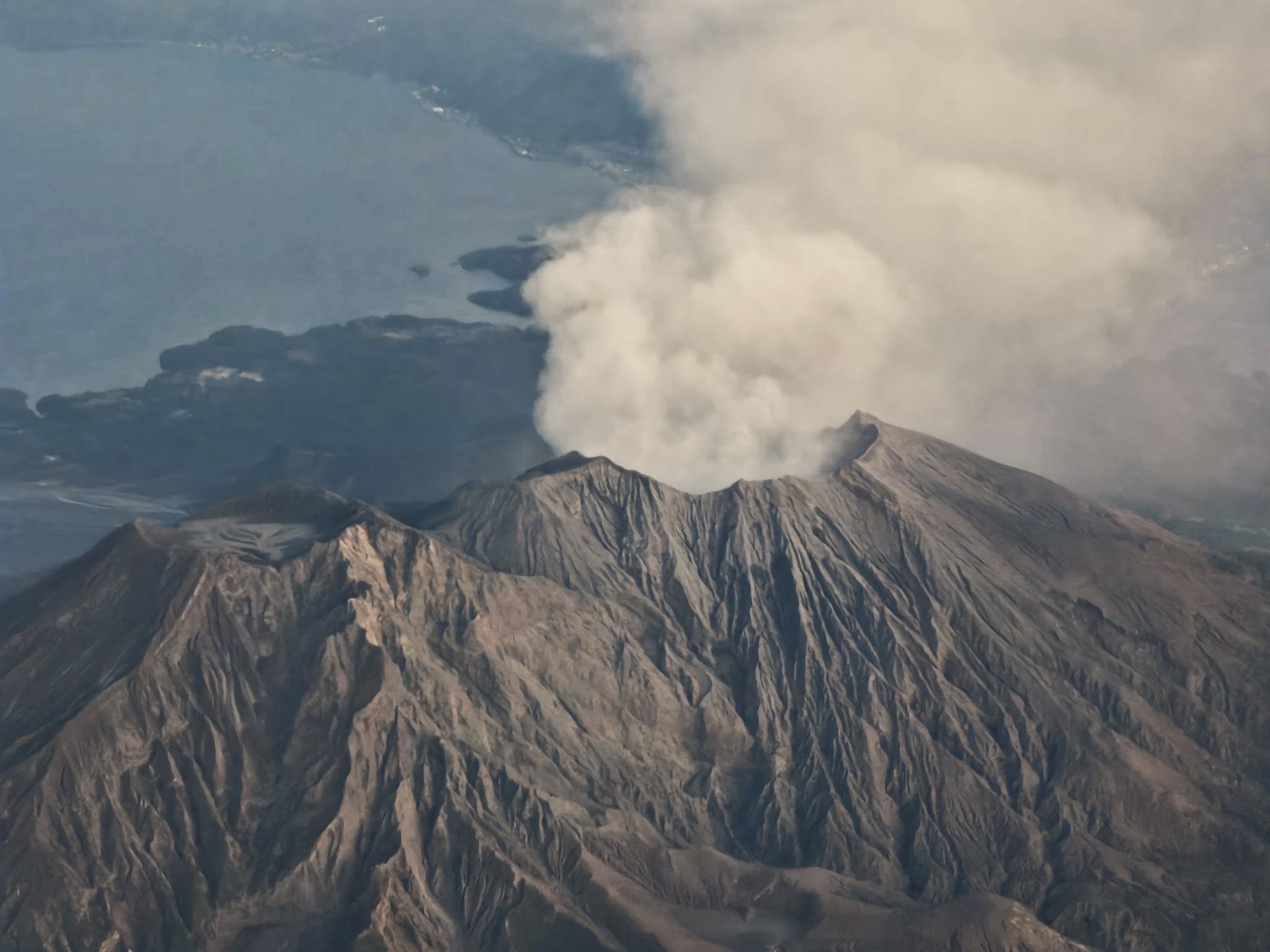
The Vanuatu Meteorology and Geohazards Department (VMGD) reported eruptive activity at Ambae during the last week of November and the first week of December based on seismic signals, satellite data, and webcam images. Steam, gas, and ash plumes were visible in satellite and webcam observations during 24-30 November and 1-5 December. A low-level thermal anomaly was also detected in satellite images during 30 November and 1-2 December. Ashfall was reported in surrounding communities downwind in late November and during 1-7 December. A webcam image from 8 December showed a plume that may have contained ash rising from the crater. According to the Wellington Volcanic Ash Advisory Center (VAAC) low-level ash plumes rose 1.8-2.4 km (6,000-8,000 ft) a.s.l. and drifted NW during 3-5 December, then rose as high as 3.7 km (12,000 ft) a.s.l. and drifted E during 7-8 December. The Alert Level remained at 2 (on a scale of 0-5), and the public was warned to stay outside of Danger Zone A, defined as a 2-km radius around the active vents in Lake Voui, and to stay away from drainages during heavy rains.
The island of Ambae, also known as Aoba, is a massive 2,500 km3 basaltic shield that is the most voluminous volcano of the New Hebrides archipelago. A pronounced NE-SW-trending rift zone with numerous scoria cones gives the 16 x 38 km island an elongated form. A broad pyroclastic cone containing three crater lakes (Manaro Ngoru, Voui, and Manaro Lakua) is located at the summit within the youngest of at least two nested calderas, the largest of which is 6 km in diameter. That large central edifice is also called Manaro Voui or Lombenben volcano. Post-caldera explosive eruptions formed the summit craters about 360 years ago. A tuff cone was constructed within Lake Voui (or Vui) about 60 years later. The latest known flank eruption, about 300 years ago, destroyed the population of the Nduindui area near the western coast.
Sources: Vanuatu Meteorology and Geohazards Department (VMGD), Wellington Volcanic Ash Advisory Center (VAAC) , GVP.
Photo : Vanuatu Air Taxi.
Japan , Sakurajima :
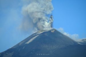
The Japan Meteorological Agency (JMA) reported ongoing eruptive activity at Minamidake Crater (Aira Caldera’s Sakurajima volcano) during 2-8 December with 11 eruptive events and nine explosions. Ash plumes rose as high as 2.2 km above the crater rim and large blocks were ejected as far as 700 m from the vent. Nightly crater incandescence was visible in webcam images. Sulfur dioxide emissions were characterized as high, averaging 2,300 tons per day on 5 December. Daily eruptive events produced ash plumes that rose 1-2.2 km above the crater rim and drifted NE and SE. Explosions at 11h07, at 20h46, at 22h12, and at 23h38 on 4 December, at 06h54 and at 22h29 on 5 December, at 02h13 on 6 December, and at 20h53 and at 18h40 on 8 December generated ash plumes that rose 600-1,700 m above the crater rim and drifted E and SE. The Alert Level remained at 3 (on a 5-level scale), and the public was warned to be cautious within 2 km of both the Minimadake and Showa craters.
The Aira caldera in the northern half of Kagoshima Bay contains the post-caldera Sakurajima volcano, one of Japan’s most active. Eruption of the voluminous Ito pyroclastic flow accompanied formation of the 17 x 23 km caldera about 22,000 years ago. The smaller Wakamiko caldera was formed during the early Holocene in the NE corner of the caldera, along with several post-caldera cones. The construction of Sakurajima began about 13,000 years ago on the southern rim and built an island that was joined to the Osumi Peninsula during the major explosive and effusive eruption of 1914. Activity at the Kitadake summit cone ended about 4,850 years ago, after which eruptions took place at Minamidake. Frequent eruptions since the 8th century have deposited ash on the city of Kagoshima, located across Kagoshima Bay only 8 km from the summit. The largest recorded eruption took place during 1471-76.
Sources: Japan Meteorological Agency (JMA), GVP.
Photo : via Vulcaniya / FB.
Philippines , Mayon :
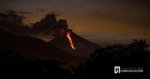
The Philippine Institute of Volcanology and Seismology (PHIVOLCS) reported increased seismic activity at Mayon and new lava at the summit in December. Photos of the summit dome on 8 and 10 December revealed that dark lava spines had been recently extruded. The seismic network detected an increase in rockfalls from an average of three events per day in 2025 to an average of 16 events per day in December, coincident with the extrusion. The Alert Level remained at 1 (on a 0-5 scale); the public was warned to stay out of the 6-km-radius Permanent Danger Zone (PDZ) and pilots were advised to avoid flying close to the summit.
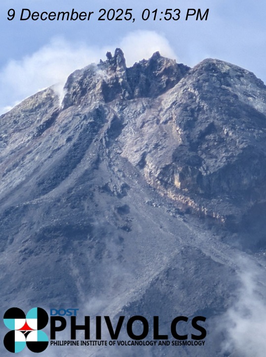
Close-up photographs of the Mayon Volcano summit taken on 8 to 10 December 2025 reveal new spines of dark lava that have been extruded from the summit lava dome. These changes were observed the past week and signal the presence of new and shallow magma within the edifice. The extrusion of new lava led to the increase of rockfall from the 2025 average of 3 events/day to 16 events/day in December 2025.
DOST-PHIVOLCS reminds the public that Alert Level 1 prevails over Mayon and entry into the 6-kilometer PDZ must be strictly prohibited due to increased chances of volcanic hazards with this development.
Sources: Philippine Institute of Volcanology and Seismology (PHIVOLCS) , GVP.
Photo : Phivolcs
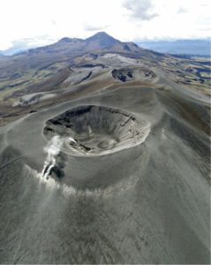
Indonesia , Ruang :
Special Report: Mount Ruang activity level downgraded from Alert Level II (Waspada) to Normal (Level I).
Mount Ruang is located in the Sitaro Regency, North Sulawesi. This active stratovolcano rises to an altitude of 725 meters. Following major eruptions on April 17 and 30, 2024, white plumes of low to moderate intensity are still escaping from the main crater, rising to a height of approximately 10 to 50 meters above the summit. These eruptions damaged the RUA3 station (located 1.5 km from the active crater) on Mount Ruang Island. Repairs were completed on July 3, 2025, and the station has been operational again since July 4, 2025.
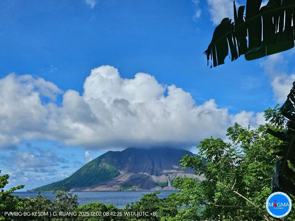
Following the eruptions of April 17 and 30, 2024, Mount Ruang’s activity decreased. From September to December 10, 2025, the height of the smoke plume visually diminished, reaching an altitude of 10 to 50 meters above the summit. The crater smoke was white, of moderate intensity, and of low pressure.
Mount Ruang’s volcanic seismicity is generally low and dominated by tectonic earthquakes, likely influenced by the subduction of North Sulawesi and the double subduction zone in the Molucca Sea. Seismic activity at Mount Ruang over the past three months indicates that it is primarily due to distant tectonic earthquakes, with the number of deep volcanic earthquakes (DVAs) ranging from 0 to 3 per day.
Following visual and instrumental monitoring, the volcanic activity level of Mount Ruang has been lowered from level II (WASPADA) to level I (NORMAL) effective December 10, 2025 at 10:00 a.m. Central Indonesian Time (WITA).
Source et photo : PVMBG.
Colombia , Purace / Los Coconucos volcanic chain :
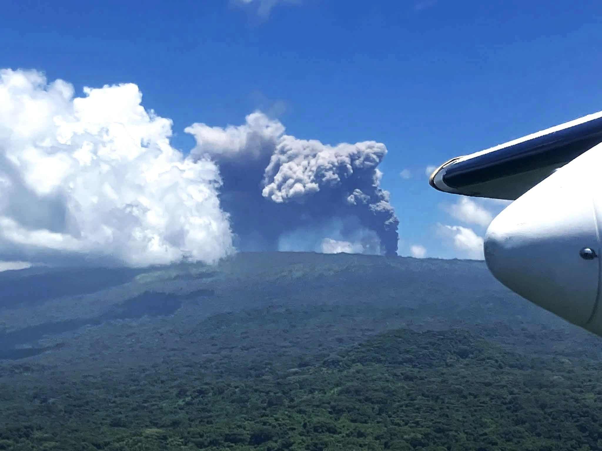
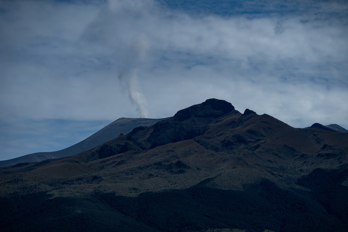
The Servicio Geologico Colombiano (SGC) reported continuing eruptive activity at Puracé during 2-9 December. Seismicity was characterized by tremor and long-period signals indicating fluid movement, periods of continuous tremor, and earthquakes indicating rock fracturing located at depths of 1-3 km. Daily gas-and-ash emissions rose 100-900 m above the summit and drifted downwind. On 3 December a temperature increase within the crater was identified in satellite data. During 2-3 December minor ashfall was reported in areas to the SE including Cristales and Agua Hirviendo. Ashfall on 3 December was reported in the Cristales area and Casa de Cabildo of Puracé (N), in Río Negro and Paletará council (16 km SW), in the Agua Hirviendo hot springs (11 km WNW), and in San Juan (NE). The Alert Level remained at Orange (the second highest level on a four-color scale) and the public was warned to stay away from the crater.
Since the publication of yesterday’s special bulletin and up to the publication of this document, earthquakes associated with fluid movements within the volcanic edifice have been recorded. These include long-period (LP) earthquakes, tremor pulses (TR), and continuous tremor. This seismicity has been located primarily beneath the Puracé volcano crater and is related to the internal dynamics of gases and their emission into the atmosphere. In addition, low-magnitude seismic signals associated with rock fracturing have been recorded within a 1.5 km radius of the Puracé volcano crater, at depths of less than 3 km.
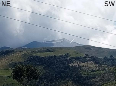
Some of these seismic signals were accompanied by ash emissions that dispersed preferentially towards the Northwest, following the wind direction, with columns reaching heights of up to 700 m. In total, seven ash emissions were recorded, for which alerts were issued to the Civil Aviation Authority. Among the highlights was the appearance of new degassing points; the photo shows a photograph of the Puracé volcano, taken by a resident of the village of Alto Anambío (municipality of Puracé), where one of these is clearly visible on the southwest flank.
Sources : Servicio Geológico Colombiano (SGC) , GVP.
Photos : SGC.