November 20 , 2025.
Indonesia , Semeru :
The activity level of Mount Semeru volcano in East Java was raised from Level III (SIAGA) to Level IV (AWAS) on November 19, 2025.
On Wednesday, November 19, 2025, at 2:13 PM (Western Indonesian Time), an eruption occurred at Mount Semeru in East Java. This eruption consisted of pyroclastic flows whose extent is unknown due to cloud cover over Mount Semeru. These pyroclastic flows resulted from a series of eruptions, not a single event. As of the date of this report, the pyroclastic flows are ongoing, with a maximum amplitude of 37 mm.
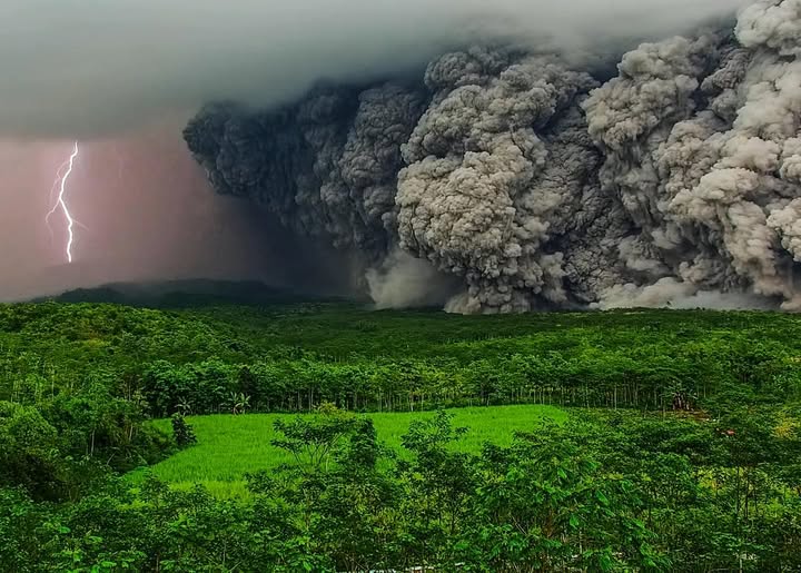
The activity at Mount Semeru indicates that eruptions and lava flows are still occurring, but are rarely visible to the naked eye due to weather conditions. During this period, the number of recorded earthquakes indicates that seismic activity at Mount Semeru remains high, including eruptive, avalanche, and harmonic tremor earthquakes. There has been an increase in avalanche earthquakes, correlating with visual observations that indicate an intensification of incandescent lava flows toward Besuk Kobokan. The recorded earthquakes demonstrate a continued supply of material from the subsurface of Mount Semeru, as well as the ejection of material onto the surface by eruptions and projections. Relative velocity values (dv/v) have been trending downward since mid-October 2025, indicating an increase in pressure near the volcano’s surface. Monitoring of deformations during this period shows relative stability, indicating the absence of an increase in the internal pressure of the volcano.
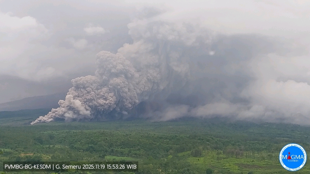
Following analysis and assessment, effective November 19, 2025, at 5:00 PM (Jakarta time), the activity level of Mount Semeru has been raised from Level III (SIAGA) to Level IV (Awas). The public, visitors, and tourists are strongly advised to refrain from all activities in the southeastern sector along the Besuk Kobokan River, within a 20 km radius of the summit (epicenter of the eruption). Beyond this distance, activities are prohibited within 500 meters of the banks of the Besuk Kobokan River. Finally, due to the risk of ejected rocks, activities are prohibited within an 8 km radius of the crater/summit of Mount Semeru.
VOLCANO OBSERVATORY NOTICE FOR AVIATION – VONA
Issued : November 19 , 20251
Volcano : Semeru (263300)
Current Aviation Colour Code : ORANGE
Previous Aviation Colour Code : orange
Source : Semeru Volcano Observatory
Notice Number : 2025SMR3311
Volcano Location : S 08 deg 06 min 29 sec E 112 deg 55 min 12 sec
Area : East java, Indonesia
Summit Elevation : 11763 FT (3676 M)
Volcanic Activity Summary :
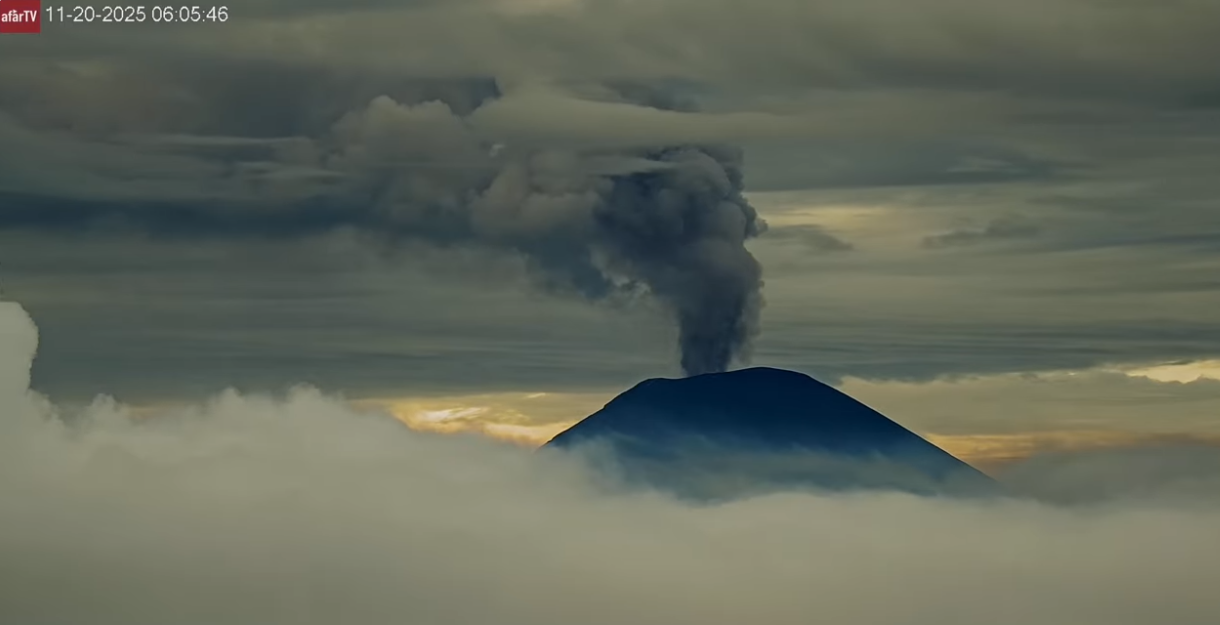
Eruption with volcanic ash cloud at 08h49 UTC (15h49 local).
Volcanic Cloud Height :
Best estimate of ash-cloud top is around 18163 FT (5676 M) above sea level or 6400 FT (2000 M) above summit. May be higher than what can be observed clearly. Source of height data: ground observer.
Other Volcanic Cloud Information :
Ash cloud moving from north to northwest. Volcanic ash is observed to be gray. The intensity of volcanic ash is observed to be thick.
Remarks :
Eruption recorded on seismogram with maximum amplitude 38 mm and maximum duration 1000 second.
Source : PVMBG
Photos : Afar TV.
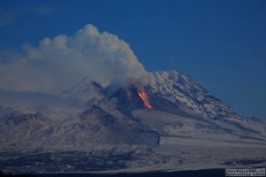
Japan , Sakurajima :
The Japan Meteorological Agency (JMA) reported ongoing eruptive activity at Minamidake Crater (Aira Caldera’s Sakurajima volcano) during 10-17 November. Nightly crater incandescence was visible in webcam images. An eruptive event at 17h33 on 10 November produced an ash plume that rose 1 km above the crater rim and drifted S. Sulfur dioxide emissions were characterized as slightly high, averaging 1,800 tons per day on 11 November. An explosion at 00h57 on 16 November generated an ash plume that rose 4.4 km above the crater rim and ejected large blocks 800-1,200 m above the vent. At 02h28 an explosion produced an ash plume that rose 3.7 km above the summit and drifted NE, and ejected blocks as far as 1.4 km above the vent. Emissions became continuous, with ash plumes rising 500-1,300 m above the summit and drifting E and N, until 03h50 when they were below the detection threshold.
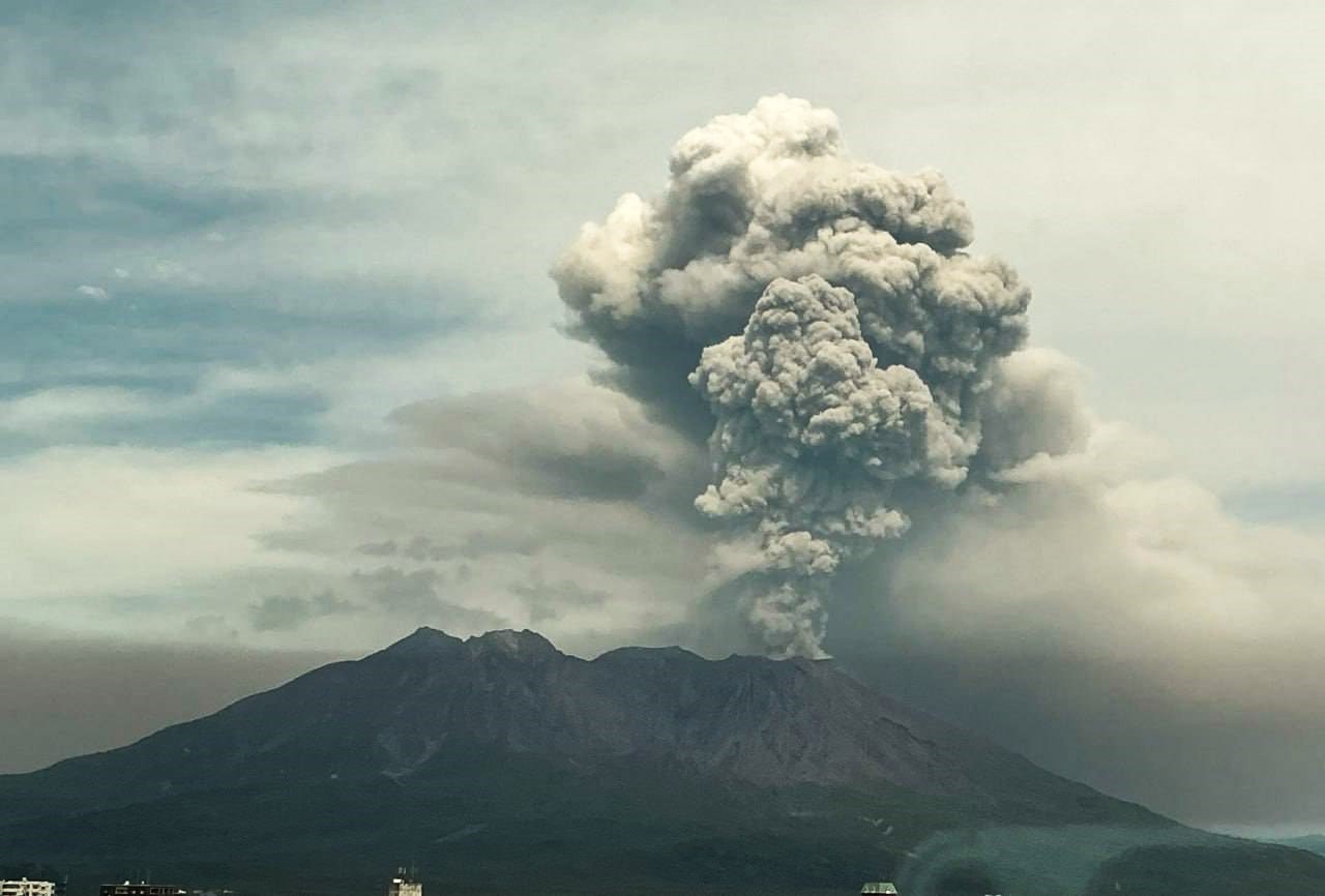
A notable amount of ashfall from the explosions was reported in Kagoshima City. Explosions at 04h34 and at 08h50 generated ash plumes that rose 1.7 and 2.5 km above the summit, respectively, and ejected blocks 300-900 m above the vent. According to news reports, about 30 flights in and out of Kagoshima Airport were canceled due to the ashfall. The fifth explosion during the week, at 05h54 on 17 November, ejected blocks 500-700 m above the vent and produced an ash plume that rose 2.4 km above the crater rim and drifted SE. Gas-and-ash plumes from eruptive events at 09h30 on 16 November and at 07h02, at 07h30, at 13h40, at 19h11, and at 19h36 on 17 November produced ash plumes that rose 1.1-1.4 km above the crater rim and drifted NE, E, and SE. The Alert Level remained at 3 (on a 5-level scale), and the public was warned to be cautious within 2 km of both the Minimadake and Showa craters.
Sources: Japan Meteorological Agency (JMA), Reuters, GVP.
Photo : Alex Tor via FB
Indonesia , Kelimutu :
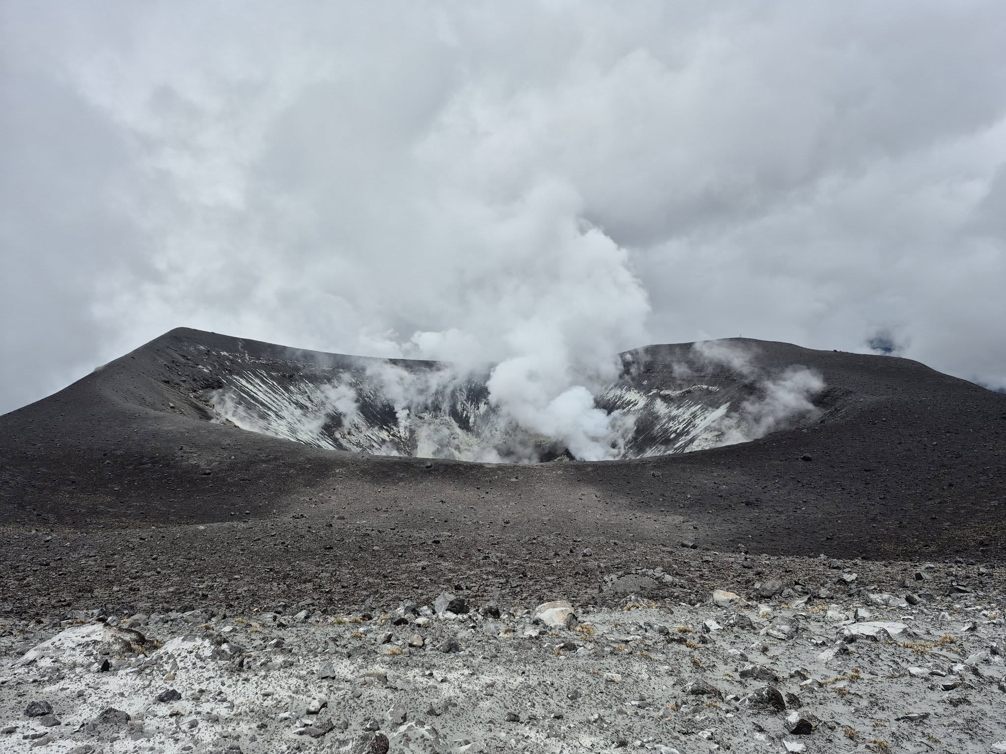
The Pusat Vulkanologi dan Mitigasi Bencana Geologi (PVMBG) reported another significant increase in the lake water temperature at Kelimutu’s Crater II (Tiwu Koofai Nuwamuri). The water temperature rose from 30.9 degrees Celsius (C) on 23 October, to 31.5 degrees C on 7 November, and then to 32.6 degrees C on 15 November. A minor sulfur odor accompanied the temperature increase along with the appearance of gas-and-steam on the lake’s surface. The color of the lake water had not changed, remaining light blue. There was no significant change in seismicity. The Alert Level remained at 1 (on a scale of 1-4) and the public was advised to not approach the crater rim and to wear a mask due to the sulfur odor.
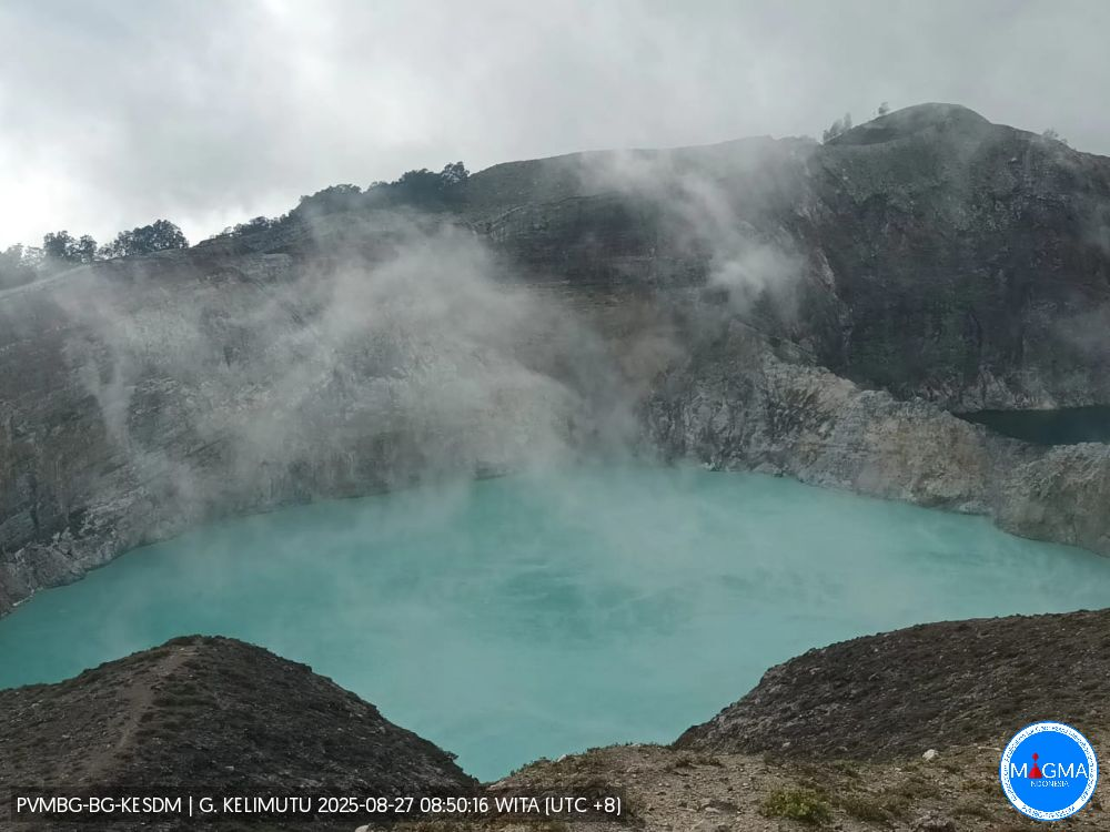
Kelimutu is a small, but well-known, Indonesian compound volcano in central Flores Island with three summit crater lakes of varying colors. The western lake, Tiwi Ata Mbupu (Lake of Old People) is commonly blue. Tiwu Nua Muri Kooh Tai (Lake of Young Men and Maidens) and Tiwu Ata Polo (Bewitched, or Enchanted Lake), which share a common crater wall, are commonly colored green and red, respectively, although lake colors periodically vary. Active upwelling, probably fed by subaqueous fumaroles, occurs at the two eastern lakes. The scenic lakes are a popular tourist destination and have been the source of minor phreatic eruptions in historical time. The summit is elongated 2 km in a WNW-ESE direction; the older cones of Kelido (3 km N) and Kelibara (2 km S).
Sources: Pusat Vulkanologi dan Mitigasi Bencana Geologi (PVMBG, also known as CVGHM), GVP.
Photo : Magma Indonésie .
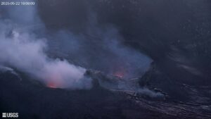
Colombia , Puracé – Los Coconucos volcanic chain :
Popayán, November 18, 2025, 2:00 PM
Regarding the monitoring of activity at the Puracé volcano – Los Coconucos volcanic chain – the Colombian Geological Survey (SGC), an agency under the Ministry of Mines and Energy, reports the following:
During the week of November 11-18, 2025, a continuous volcanic tremor signal continued to be recorded. This tremor is associated with the intensification of degassing in the Puracé volcano crater, observed since the end of September.
Earthquakes related to fluid movement showed an increase in the number of events and the energy released, primarily located beneath the western flank of the crater, at depths of less than 1 km. Compared to observations from previous weeks, fracture seismicity remained stable, both in number and seismic energy released. The events occurred primarily between the Puracé, Piocollo, and Curiquinga volcanoes, at depths of 1 to 3 km, with a maximum magnitude of 1.3. Sulfur dioxide (SO₂) emissions detected by satellite and field instruments remained within the range of levels recorded in previous weeks. Furthermore, the slow deformation process continues between the Puracé, Piocollo, and Curiquinga volcanoes, as demonstrated by the Curiquinga eruption on January 20, 2025.
Images captured by satellite sensors and visible and infrared webcams showed continued degassing processes within the crater of Mount Purace, forming a gas column that reached a maximum height of 1,740 meters measured from the summit. Thermal anomalies were also observed inside the crater and in the fumarole field on its outer rim.
It is worth noting the appearance of a gas emission from a fissure inside the crater of Mount Curiquinga, which began this morning. This emission is characterized by its white color and a height not exceeding 100 meters. This fissure formed during the ash emission episodes of March 29, 2022, and January 20, 2025, after which no gas emissions were detected at the surface of this crater.
In conclusion, the observed variations at the Puracé volcano – part of the Los Coconucos volcanic chain – indicate that the system continues to evolve and that monitoring parameters remain above their reference values. Therefore, the public is advised to refrain from climbing to the upper reaches of the volcanic chain. During a yellow alert, phenomena such as sporadic ash emissions (minor eruptions with limited range and effects, the dispersion of which depends on wind direction), incandescence, small explosions in the crater, low-energy thermal anomalies, noise, felt seismic tremors, odors, elemental sulfur precipitation near the crater and in hot springs and fumaroles, as well as degassing in areas other than the crater, may occur. Other possible phenomena include the formation of fissures and the occurrence of minor lahars.
The alert level for volcanic activity remains at yellow alert: Active volcano with changes in the basic behavior of monitored parameters and other manifestations.
Source et photo : SGC.
Philippines , Taal :
The Philippine Institute of Volcanology and Seismology (PHIVOLCS) reported eruptive activity at Taal during 12-18 November. The seismic network recorded 10-20 daily volcanic earthquakes along with periods of volcanic tremor on 12 and 16 November. One minor phreatic event occurred on 12 November and lasted for three minutes; voluminous emissions rose 2.8 km above the crater rim and drifted NE. Daily gas-and-steam emissions with variable densities rose 400-900 m above the crater rim and drifted SW during the rest of the week.
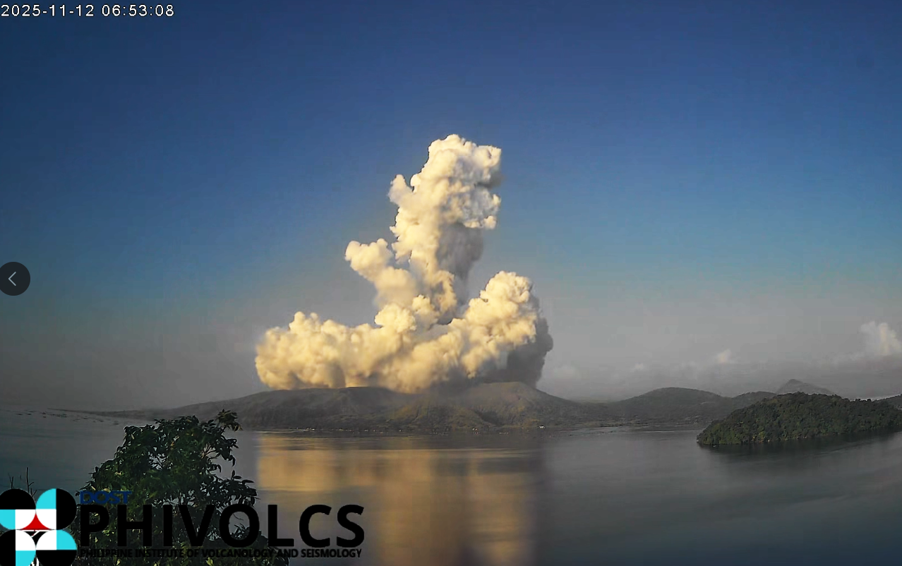
. Sulfur dioxide emissions decreased during the week, averaging 1,095 tonnes per day (t/d) on 12 November, 339 t/d on 14 November, and 72 t/d on 17 November. The Alert Level remained at 1 (on a scale of 0-5); PHIVOLCS reminded the public that the entire Taal Volcano Island (TVI) was a Permanent Danger Zone (PDZ) and recommended that the Main Crater and areas along the Daang Kastila fissure should remain prohibited. Pilots were warned to avoid flying over TVI.
Source et photo : Philippine Institute of Volcanology and Seismology (PHIVOLCS) , GVP.