July 13 , 2025.
Indonesia , Dukono :
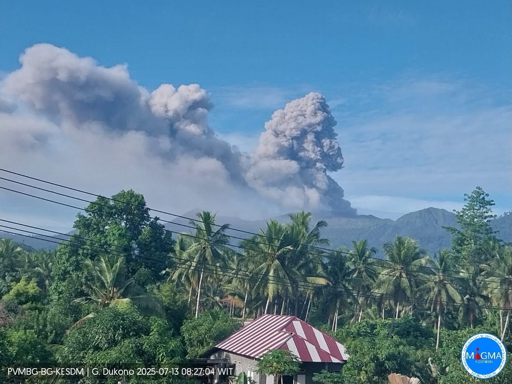
Mount Dukono erupted on Sunday, July 13, 2025, at 8:17 a.m. (local time). An ash column was observed about 1,200 m above the summit (about 2,287 m above sea level). The ash column was white to gray in color, with strong intensity moving eastward. At the time of writing, the eruption was still ongoing.

Seismicity Observations:
136 eruption earthquakes with amplitudes ranging from 6 to 34 mm and durations ranging from 39.68 to 174.27 seconds.
One felt earthquake with an amplitude of 34 mm on the MMI II scale, with no observed magnitude, and a duration of 89.02 seconds.
Three distant tectonic earthquakes with amplitudes ranging from 6 to 20 mm, magnitudes ranging from 15.74 to 22.84 seconds, and durations ranging from 82.88 to 84.42 seconds.
One continuous tremor with an amplitude ranging from 1 to 6 mm, with a principal value of 2 mm.
Recommendations
(1) Residents of the vicinity of Mount Dukono and visitors/tourists are advised to avoid all activity, climbing, or approaching the Malupang Warirang Crater within a 4 km radius. (2) Since volcanic ash eruptions occur periodically, and the distribution of ash depends on wind direction and speed, so the area where the ash lands is not constant, people around Mount Dukono are advised to always wear masks/mouth and nose coverings to avoid the threat of volcanic ash to the respiratory system.
Source et photo : Magma Indonésie .
Indonesia , Papandayan :
THE PHENOMENON OF BLUE FLAMES ON THE WALLS OF THE NEW CRATER OF PAPANDAYAN VOLCANO, JULY 12, 2025.
At Papandayan Volcano, located in Garut Regency, West Java Province, on July 12, 2025, at 7:00 PM WIB, blue flames were observed on the walls of the new crater. The appearance of blue flames may be caused by an increase in the temperature of the solfatara. This increase in temperature, coupled with the presence of oxidized sulfur, gives rise to a blue light. Seismicity showed an increase in the number of shallow volcanic earthquakes during the last two weeks of June 2025. This blue flame phenomenon also occurred in March 2023.
Papandayan seismicity during the period July 1–12 (until 18:00 WIB) showed:
4 emission earthquakes,
2 low-frequency earthquakes,
29 shallow volcanic earthquakes,
13 deep volcanic earthquakes,
7 local tectonic earthquakes,
18 distant tectonic earthquakes
.
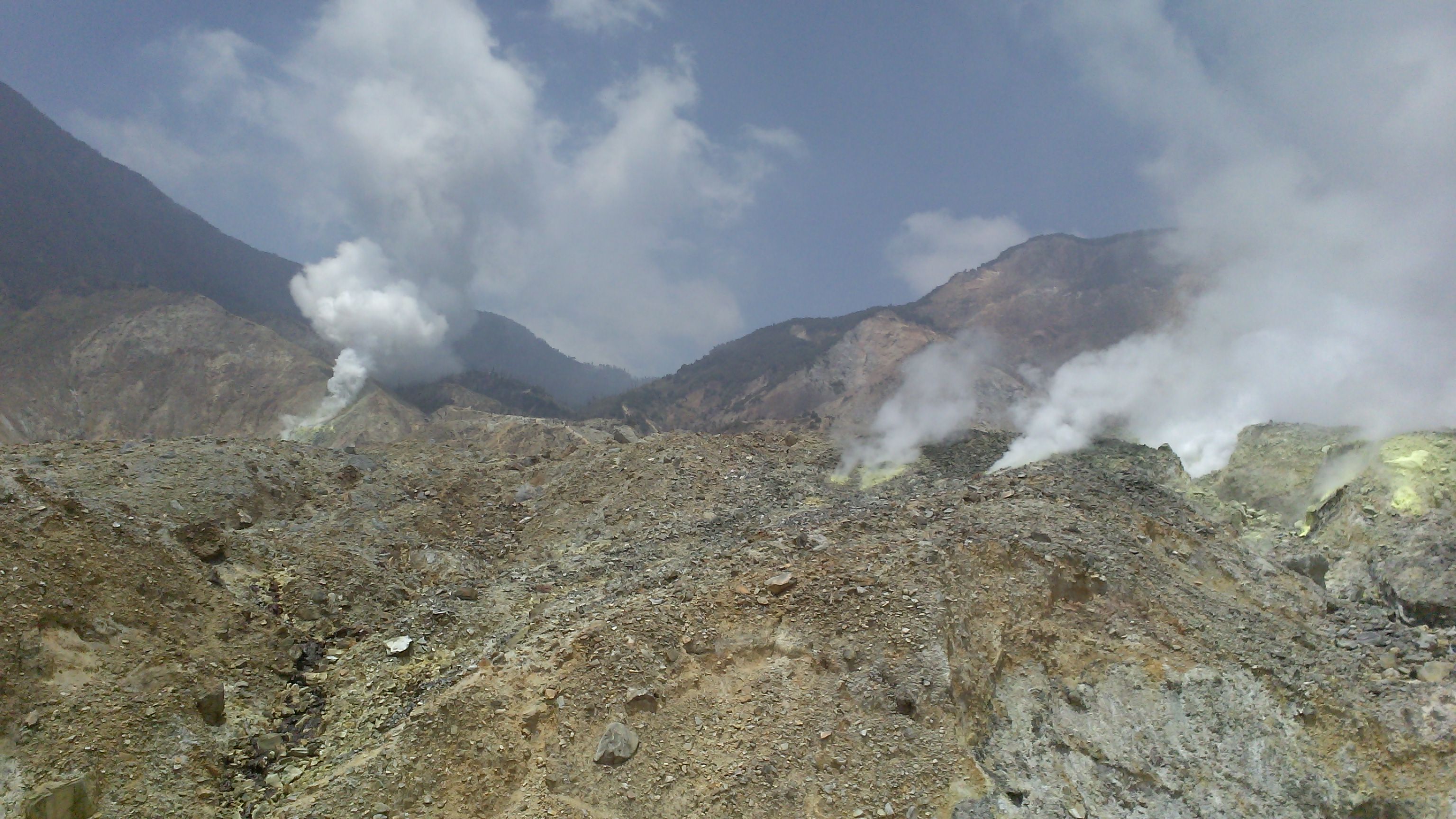
Thin to thick white smoke was observed from the walls of Kawah Baru and Kawah Mas, rising from a height of 5 to 30 meters. Visually, the smoke from Kawah Baru on July 12, 2025, at 9:40 PM WIB (field verification results) showed thick smoke, observed from the walls of Kawah Baru, rising from a height of 15 to 30 meters, with the wind blowing westward. Based on current visual and instrumental observation data, the activity level of G. Papandayan remains at Level I (Normal), with the following recommendations:
Communities living around Mount Papandayan and visitors, tourists, and mountaineers should refrain from activities and sleeping within the active crater opening area of the Mount Papandayan complex, particularly within the Kawah Baru, Kawah Emas, Kawah Nangklak, and Kawah Manuk/Balagadama craters, within a radius of 500 meters. Be vigilant for potentially increasing toxic gas concentrations and sudden phreatic eruptions.
Source : PVMBG
Photo : G Vitton .
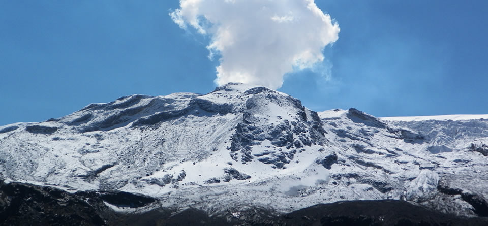
Colombia , Nevado del Ruiz :
Manizales, July 8, 2025, 5:10 p.m.
Regarding the monitoring of the activity of the Nevado del Ruiz volcano, the Colombian Geological Survey (SGC), an entity attached to the Ministry of Mines and Energy, reports that:
From July 1 to 7, 2025, the volcano continued to exhibit unstable behavior. Compared to the previous week, the main variations in the monitored parameters were:
– Seismic signals related to fluid dynamics in volcanic conduits recorded an increase in the number of events and a decrease in the seismic energy released. The energy levels of these signals were generally low to occasionally moderate. The cameras (conventional or thermographic) used to monitor the volcano confirmed pulsatile ash emissions associated with these signals. However, the decrease observed in recent weeks in the confirmation of this phenomenon, as well as in the variations in the apparent temperature of the ejected materials, is not only due to a decrease in seismic signals related to this surface phenomenon, but also to the persistence of cloudy atmospheric conditions in the region.
– Seismic activity associated with rock fracturing processes within the volcanic edifice maintained similar levels in terms of the number of recorded earthquakes and the increase in released seismic energy. The seismic events were located mainly in the Arenas crater and on the northeast, northwest, and south flanks of the volcano, at distances of up to 10 km from the crater. The depth of the earthquakes ranged from less than 1 km to 6 km from the volcanic summit. The highest magnitude of the week was 1.6, corresponding to the earthquake recorded on July 4 at 3:55 p.m., located 10 km northwest of the crater, at a depth of 6 km. – The emission of water vapor and gases, mainly sulfur dioxide (SO2), into the atmosphere from the Arenas crater was variable. Estimated values of the flux associated with SO2 degassing showed values similar to those recorded the previous week.
Satellite monitoring, currently underway to assess this parameter, continues to show SO2 releases.
– The height of the gas, ash, and water vapor column remained below 1,000 m, measured above the volcano’s summit. It should be noted, however, that this estimate was influenced by the area’s high cloud cover. The plume dispersion direction showed a predominant trend toward the west-northwest, northwest, and west-southwest flanks of the volcano.
– During monitoring of thermal anomalies at the floor of Arenas Crater, no reports were received from satellite monitoring platforms, as detection was limited by the area’s high atmospheric cloud cover.
Source : SGC.
Photo : Milton H Arias.
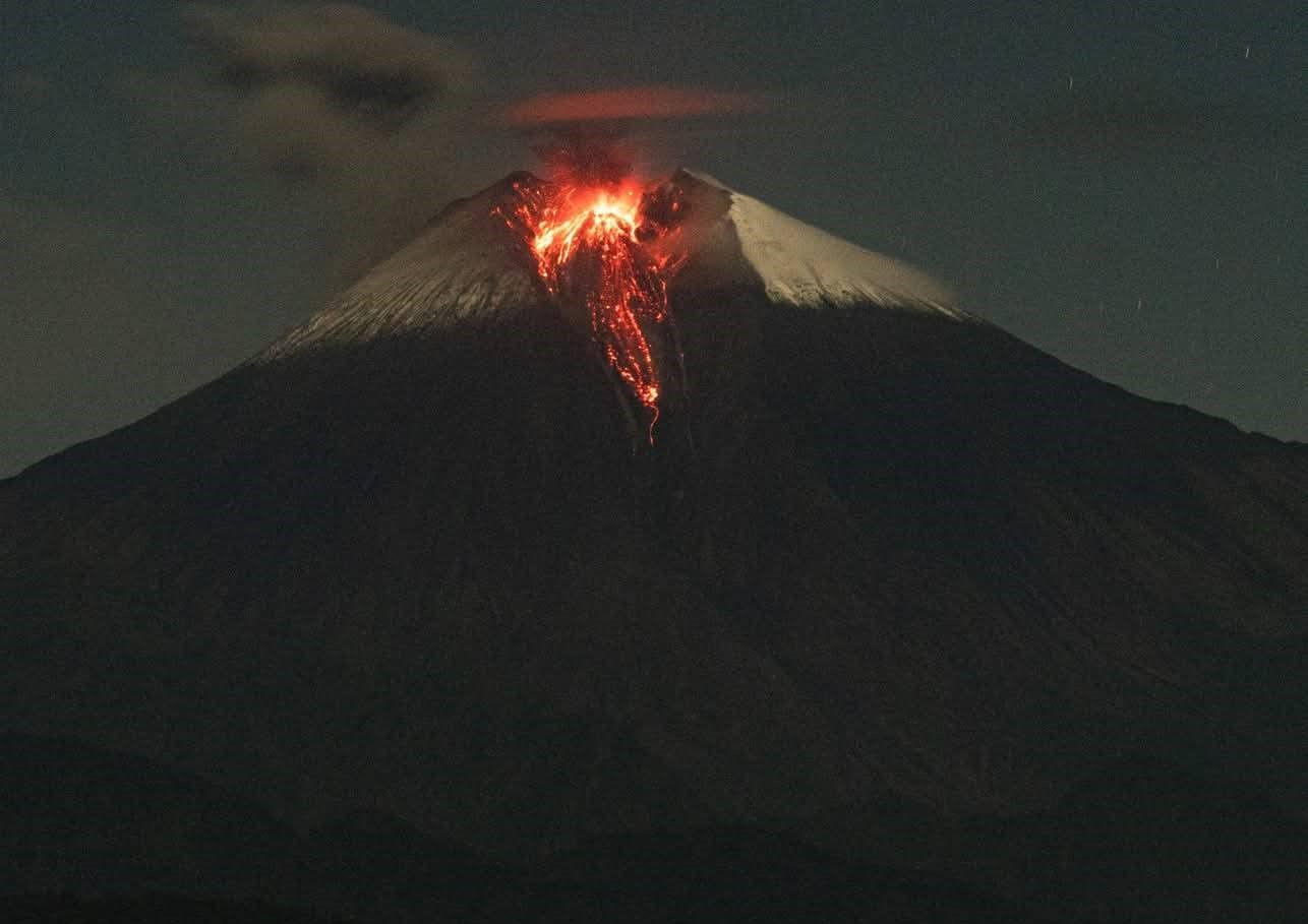
Ecuador , Sangay :
DAILY STATUS REPORT OF SANGAY VOLCANO, Saturday, July 12, 2025.
Information Geophysical Institute – EPN.
Surface Activity Level: High, Surface Trend: No Change
Internal Activity Level: Moderate, Internal Trend: No Change
Seismicity: From July 11, 2025, 11:00 a.m. to July 12, 2025, 11:00 a.m.:
Seismicity:
Below is the count of seismic events recorded at the reference station.
Explosion (EXP): 76
Rainfall/Lahars:
This morning, light rain was recorded in the volcanic area, but it did not generate mudflows or debris flows. **Heavy rains could remobilize accumulated material, generating mudflows and debris flows that would cascade down the sides of the volcano and flow into adjacent rivers.**
Emission Columns/Ash:
Due to adverse weather conditions in the volcanic area, it was not possible to observe any gas and/or ash emissions via the surveillance camera network. However, last night, using the GOES-19 satellite system, a gas plume was detected in a west-southwest direction 1,200 meters above the crater. Meanwhile, the Washington-based VAAC agency issued four reports of ash plumes rising in a west-southwest direction 1,200 meters above the crater.
Gas:
The MOUNTS satellite system did not detect levels of sulfur dioxide (SO2).
Observation:
From yesterday afternoon until the closing of this report, the volcano remained completely cloudy.
Alert Level: Yellow
Source : IGEPN
Photo : Cristopher Cárdenas , 12/06/2025
Guatemala , Santiaguito :
Activity
The Santa María-Santiaguito Volcanic Complex Observatory reports volcanic activity at the Caliente Dome. Faint, white to blue, degassing fumaroles composed of water vapor and other magmatic gases have been observed up to 500 meters above the dome, moving southwest. Incandescence was observed at the Caliente Dome in the early morning hours, and weak explosions produced gray ash columns 700 meters above.

This activity could cause ash fallout in communities west of the volcanic complex, such as Loma Linda and the surrounding area. Activity remains elevated, leaving the potential for generating long-distance density pyroclastic flows to the southwest, south, and southeast.
Source : Insivumeh .
Photo : Annie Winson , earthobservatory.sg