June 14 , 2025.
Alaska , Spurr :
Unrest continues at Mount Spurr. The level of activity is still above background, but lower than observed in early 2025. This decrease in activity suggests that the magma intrusion beneath Mount Spurr has stalled. The likelihood of an eruption has declined since March, but fluctuations in unrest are not uncommon, and explosive eruptions like those in 1953 and 1992 are still possible. Should unrest escalate towards an eruption, we expect increases in seismic activity, gas emissions, surface deformation, and surface heating.
During the past week, 44 earthquakes were located, all smaller than magnitude 1. The number of located earthquakes this week is about the same as last week, and both are lower than other recent weeks. However, they are within the variability observed from week to week during this entire period of unrest. AVO conducted a flight to Mount Spurr on Thursday, June 12, to measure gas emissions and make observations, finding that gas compositions and emission rates were broadly unchanged from those measured during the previous gas flight on May 23. Minor sulfur dioxide emissions were detected in satellite data several days this week. Ground deformation at Mount Spurr has stopped over the past two months, which is further evidence that the magma intrusion has paused.
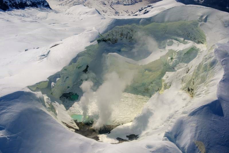
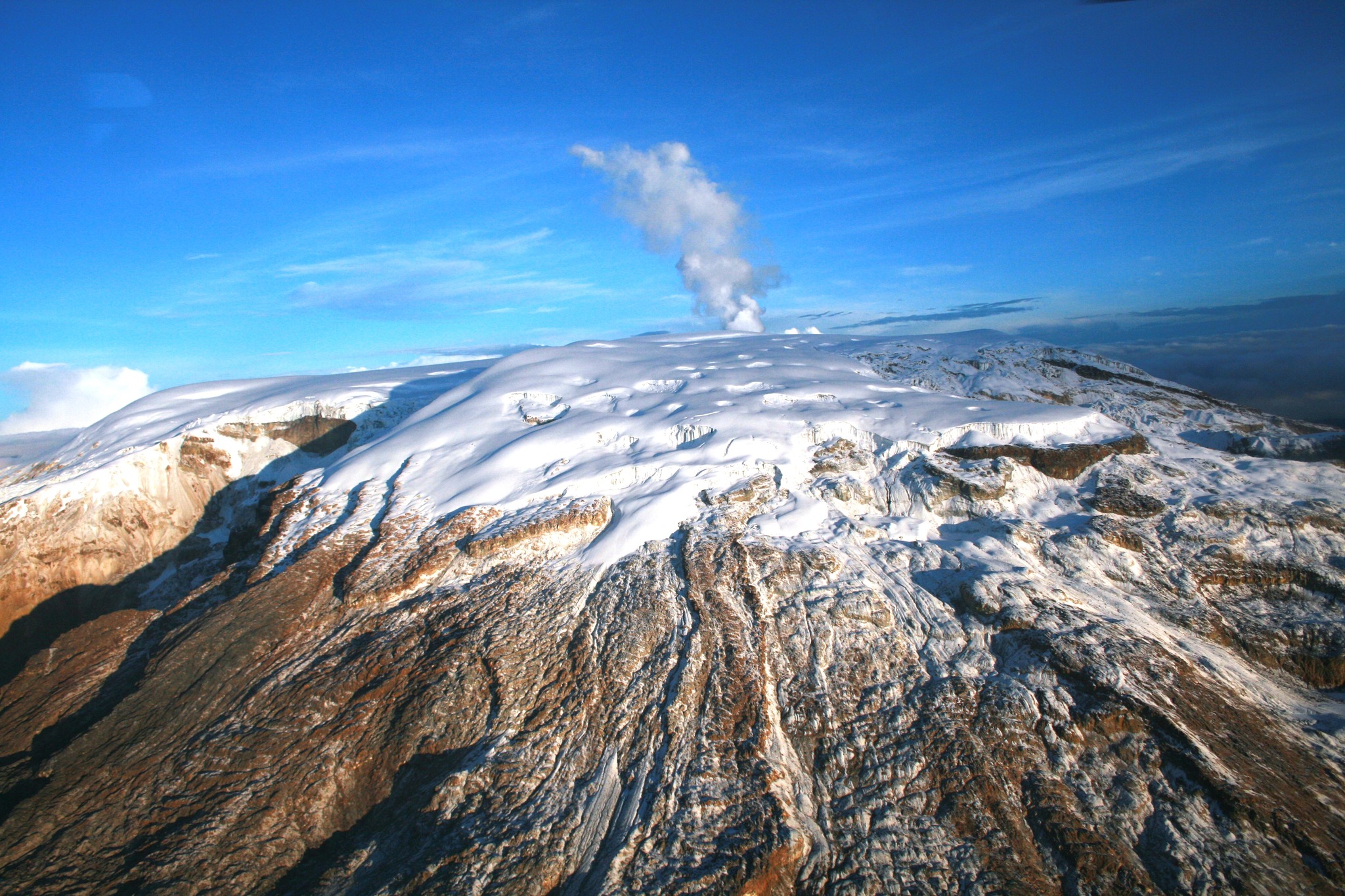
Mount Spurr summit from the north during a gas and photo survey on June 11, 2025. Sulfur has stained the snow yellow within the summit crater. Fumaroles are producing a light steam plume from the north shore of the crater lake. Most of the lake’s surface is ice covered.
Views of the summit from local web cameras and in high-resolution satellite data showed a vapor plume when viewing conditions were clear. No significant surface changes were observed at Mount Spurr over the past week.
AVO continues to closely monitor activity at Mount Spurr for signals indicating the volcano is moving closer to an eruption using local seismic, infrasound, and GNSS (GPS) stations, web cameras, airborne and satellite gas measurements, regional infrasound, lightning networks, and satellite images.
Source : AVO
Photo : Loewen, Matt/ AVO/USGS.
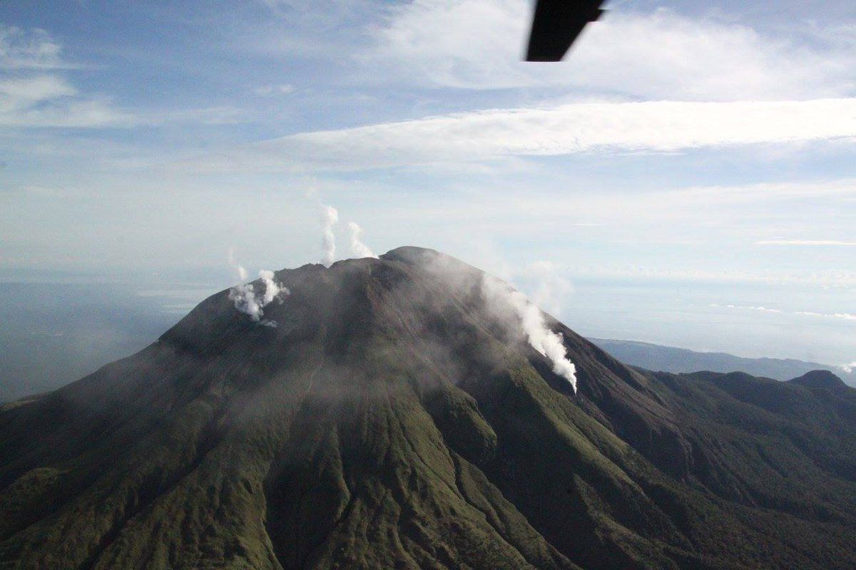
Philippines , Bulusan :
Bulusan Volcano Advisory , Issued: 02:00 PM, June 13, 2025
Recent visual observations and ongoing monitoring by the Provincial Disaster Risk Reduction and Management Office (PDRRMO)—Emergency Operation Center (EOC) have shown degassing vent activity in the southern and southeastern sectors of the volcano, specifically near Brgy. Mapaso in the Municipality of Irosin and Brgy. San Roque in the Municipality of Bulusan since June 12, 2025
In view of this, all Local Disaster Risk Reduction and Management Offices (LDRRMOs) within the vicinity of Bulusan Volcano are to implement appropriate local measures and promptly disseminate information to the public to ensure preparedness and effective response, especially in areas vulnerable to volcanic hazards such as pyroclastic density currents, rockfall, ashfall and others associated risks.
The public in LGUs near Bulusan Volcano is hereby advised to remain vigilant, as Alert Level 1 remains in effect and the risk of phreatic eruptions persists. In case of heightened volcanic activity, residents in these areas are reminded to keep essential items ready, such as face masks, clean hand towels or cloths, drinking water, and emergency supplies.
Source : RADEN D. DIMAANO, C.E., PGDH-PDRRMO
Photo : Phivolcs.
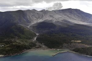
Indonesia , Ibu :
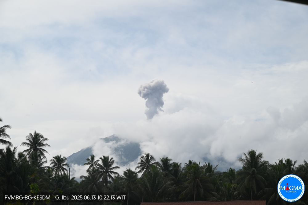
An eruption of Mount Ibu occurred on Friday, June 13, 2025, at 10:22 WIT. The observed ash column was ± 400 m above the summit (± 1725 m above sea level). The ash column was gray and of strong intensity, oriented towards the southwest. This eruption was recorded by a seismograph with a maximum amplitude of 28 mm and a duration of 63 seconds.
VOLCANO OBSERVATORY NOTICE FOR AVIATION – VONA
Issued : June 13 , 2025
Volcano : Ibu (268030)
Current Aviation Colour Code : ORANGE
Previous Aviation Colour Code : orange
Source : Ibu Volcano Observatory
Notice Number : 2025IBU841
Volcano Location : N 01 deg 29 min 17 sec E 127 deg 37 min 48 sec
Area : North Maluku, Indonesia
Summit Elevation : 4240 FT (1325 M)
Volcanic Activity Summary :
Eruption with volcanic ash cloud at 01h22 UTC (10h22 local).
Volcanic Cloud Height :
Best estimate of ash-cloud top is around 5520 FT (1725 M) above sea level or 1280 FT (400 M) above summit. May be higher than what can be observed clearly. Source of height data: ground observer.
Other Volcanic Cloud Information :
Ash cloud moving to southwest. Volcanic ash is observed to be gray. The intensity of volcanic ash is observed to be thick.
Remarks :
Eruption recorded on seismogram with maximum amplitude 28 mm and maximum duration 63 second.
Source et photo : Magma Indonésie .
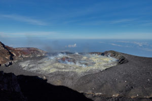
Colombia , Nevado del Ruiz :
Manizales, June 10, 2025, 7:15 p.m.
Regarding the monitoring of the activity of the Nevado del Ruiz volcano, the Colombian Geological Survey (SGC), an entity affiliated with the Ministry of Mines and Energy, reports that:
From June 3 to 9, 2025, the volcano continued to exhibit unstable behavior. Compared to the previous week, the main variations in the monitored parameters were:
– Seismic activity associated with rock fracturing processes within the volcanic edifice increased, both in the number of recorded events and in the seismic energy released. Most of the seismic events were located in the Arenas crater and in the west-southwest sector, less than 6 km from the crater, and, to a lesser extent, in the north-northwest, northeast, and east-southeast sectors of the volcano. The depth of the earthquakes ranged from 2 km to 6 km, measured from the volcanic summit. The strongest earthquake of the week was recorded on June 5 at 8:58 a.m., with a magnitude of 2.2, 5 km west-southwest of the crater, at a depth of 5 km. This earthquake occurred during a slight seismic intensification recorded in the aforementioned sector between June 5 and 6. Furthermore, the seismic intensification observed in the Arenas crater on June 4, with a maximum magnitude of 1.6, is noteworthy.
– The number of recorded seismic signal events related to fluid dynamics in volcanic conduits generally decreased, with the exception of long-duration signals, which increased. Although the energy levels of the seismic signals were predominantly low, moderate to high values were observed on June 6. Cameras (conventional or thermographic) used to monitor the volcano confirmed some pulsatile ash emissions associated with the seismic signals, despite persistent cloudy skies in the region. Water vapor and gas emissions, primarily sulfur dioxide (SO₂), into the atmosphere from the Arenas crater were variable and increased compared to previous weeks. This increase was mainly observed from June 4 onward. Satellite monitoring, carried out to complement the assessment of this parameter, also revealed significant SO₂ emissions.
– The vertical height of the gas and water vapor column remained below 400 m. In terms of dispersion, the maximum altitude reached was 1,800 m during the pulsatile ash emission recorded on June 5 at 3:30 p.m. The direction of ash column dispersion showed a predominant trend toward the west-northwest flank of the volcano, with occasional variations toward the northwest and west-southwest.
– No reports were received from satellite monitoring platforms during the thermal anomaly surveys at the floor of Arenas Crater, as detection was limited by the atmospheric conditions of heavy cloud cover in the area.
The status of volcanic activity remains at yellow alert: active volcano with changes in the baseline behavior of monitored parameters and other manifestations.
Source et photo : SGC.
Mexico , Popocatepetl :
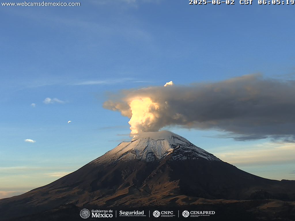
June 13, 11:00 a.m. (June 13, 5:00 p.m. GMT), Activity in the last 24 hours
68 low-intensity exhalations were detected, accompanied by water vapor, other volcanic gases, and occasionally small amounts of ash. 107 minutes of low-amplitude tremor were also recorded (71 of which were high-frequency and 36 harmonic).
Visibility was poor this morning at the time of writing.
The Popocatépetl volcano fire alert is at Yellow Phase 2.
The expected scenarios for this phase are as follows:
A few minor to moderate explosions
Occurrence of tremors of varying amplitude
Light to moderate ashfall in surrounding towns and some more distant towns
Expulsion of incandescent fragments within a 12-kilometer exclusion radius
Lahars descending into ravines are expected due to ash accumulation on the slopes and their interaction with the precipitation expected in the coming weeks
Possibility of pyroclastic flows not reaching towns
Source et photo : Cenapred .