March 20 , 2025.
Hawaii , Kilauea :
HAWAIIAN VOLCANO OBSERVATORY STATUS REPORT , U.S. Geological Survey
Wednesday, March 19, 2025, 6:02 AM HST (Wednesday, March 19, 2025, 16:02 UTC)
19°25’16 » N 155°17’13 » W,
Summit Elevation 4091 ft (1247 m)
Current Volcano Alert Level: WATCH
Current Aviation Color Code: ORANGE
Activity Summary:
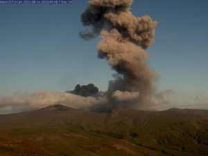
Episode 14 of the ongoing Halemaʻumaʻu eruption has not started yet, but six small, short-lived lava flows have erupted between midnight and 6:00 a.m. HST.
Small, short-lived, sluggish lava flows began overflowing the south vent just before midnight. The first flow was active from 23:58 p.m. HST March 18 to 00:02 a.m. HST March 19 and the second from 00:56 to 1:03 a.m. HST. These were followed by a third tongue of lava from the south vent from 1:57 to 2:01 a.m. HST and a fourth from 3:36 to 3:46 a.m. HST. The fifth and sixth sluggish lobes erupted from 4:20 a.m. to 4:28 a.m. HST and 5:04 to 5:14 a.m. HST. None of the flows lasted more than 10 minutes nor went more than about 50 feet (15 meters) from the south vent. Occasional spatter bursts could be seen in the north vent on the V1 camera throughout the night and becoming more frequent in the early morning hours. The small overflows from the south vent and observed spattering in the north vent show that magma is very near the surface in both vents.

Later in the morning on March 19, the northern eruptive vent joined its southern counterpart in effusing a lava flow onto the western floor of Halemaʻumaʻu crater at the summit of Kīlauea. Here, both vents and lava flows are seen from above on the western crater rim.
Tilt has remained relatively flat through each of these events though they are marked by very small spikes in tremor. Inflationary tilt remains stalled since yesterday evening and has recovered only 11.5 microradians in the last week of the 13 microradian deflationary loss during episode 13. Seismic tremor remains near background levels except for the small increases associated with the short-lived lava flows.
The continuous eruption of lava accompanied by fountaining that would mark episode 14 has not yet begun but is likely to start in the next 24 hours. If this episode follows the pattern of prior episodes preceded by short-lived flows in the current eruption, continuous eruption of lava should begin within 12 hours after the onset of the small flows or by noon today. The onset of fountains would be expected within a few hours after that.
Wednesday, March 19, 2025, 11:20 AM HST (Wednesday, March 19, 2025, 21:20 UTC).
Activity Summary:
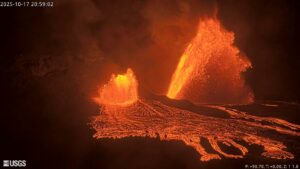
Episode 14 of the ongoing Halema’uma’u eruption of Kīlauea volcano began continuous lava effusion from the north vent at 9:26 a.m. HST March 19 in Hawai’i Volcanoes National Park. Precursory activity of seven small, short-lived lava flows erupted between midnight and 6:00 a.m. HST. Continuous eruptions of lava began at the north vent at 9:26 a.m. HST followed by lava overflowing the south vent at about 9:50 a.m. HST. Low dome fountaining is intermittently present as gas rich magma starts to mix with the degassed magma. High fountains should begin within the next several hours.
Each episode of Halemaʻumaʻu lava fountaining since December 23, 2024, has continued for 13 hours to 8 days and episodes have been separated by pauses in eruptive activity lasting less than 24 hours to 12 days.
Kīlauea’s current eruption in Halemaʻumaʻu crater within Kaluapele (the summit caldera) began on December 23, 2024. There have been 13 episodes of lava fountaining separated by pauses in activity. Episode 13 ended at 3:13 p.m. HST on March 11. All eruptive activity remains within Hawai’i Volcanoes National Park. No significant activity has been noted along Kīlauea’s East Rift Zone or Southwest Rift Zone.
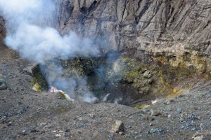
At the summit of Kīlauea on March 19, 2025, the onset of draining at the northern eruptive vent within Halemaʻumaʻu crater included intense gas jetting, spraying small droplets of lava vertically.
Summit Observations:
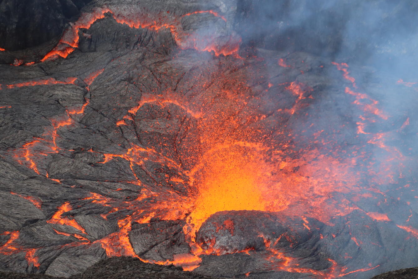
Small, degassed lava flows began erupting continuously from both vents within Halemaʻumaʻu crater beginning at 9:26 a.m. HST from the north vent and 9:50 a.m. HST from the south vent. The occasional spatter bursts in both cones slowly waned throughout the morning after 7:00 a.m. HST, but activity in both cones picked back up around 9:20 a.m. HST just prior to the start of continuous eruption. The south vent flows shut off around 10:35 a.m. HST. Cyclic low dome fountains have been alternating with short drainbacks every 5-10 minutes with the interval decreasing over time. Maximum dome fountains are 30 feet high (10 meters) and are occurring within a 200 foot by 150 foot (65 by 45 meters) lava pond that drops about 5-10 feet (2-3 meters) during each drainback event within the north cone. Fountain heights are expected to grow within the next several hours as gas-rich magma increases as the denser, degassed lava is erupted from the vent.
The rate of summit inflationary tilt has plateaued over the past 24 hours. The Uēkahuna (UWD) tiltmeter has recorded just over 11 microradians of inflationary tilt since the end of episode 13. The UWD tiltmeter had to be reset Friday March 15 creating a small offset in the data. Seismic tremor decreased significantly at the end of episode 13 but remains above background.
An SO2 emission rate of 1,200 t/d was measured on March 18, which is a typical rate for eruption pauses. As the eruption continues gas emissions are expected to increase dramatically as well as the production tephra such as pumice and Pele’s hair that can be transport long distances downwind from the vents.
Source : HVO
Photos : USGS / M. Zoeller. USGS / M. Patrick.
Italy / Sicily , Etna :
Etna Activity Report, March 19, 2025, 11:38 PM (22:38 UTC).
The National Institute of Geophysics and Volcanology, Osservatorio Etneo, reports that starting at 9:25 PM UTC, Strombolian activity is observed from several vents in the Southeast Crater. The forecast model indicates that any eruption clouds would disperse in an east-southeast direction.
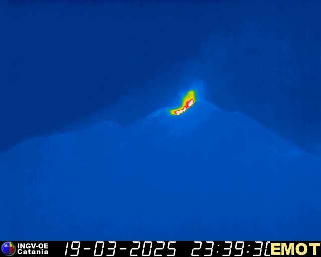
From a seismic perspective, since 19:30 UTC, the average amplitude of volcanic tremor has shown a sudden increase and has currently reached almost the high range. The centroid of the tremor sources is located in the Southeast Crater area at an altitude of approximately 2,900 m above sea level. Infrasound activity appears weak, but with a modest increasing trend. The few localized infrasound events, all of low amplitude, are located in the Southeast Crater.
Ground deformation monitoring networks do not show any significant variations.
Further updates will be provided shortly.
Source : INGV.
Photo : INGV
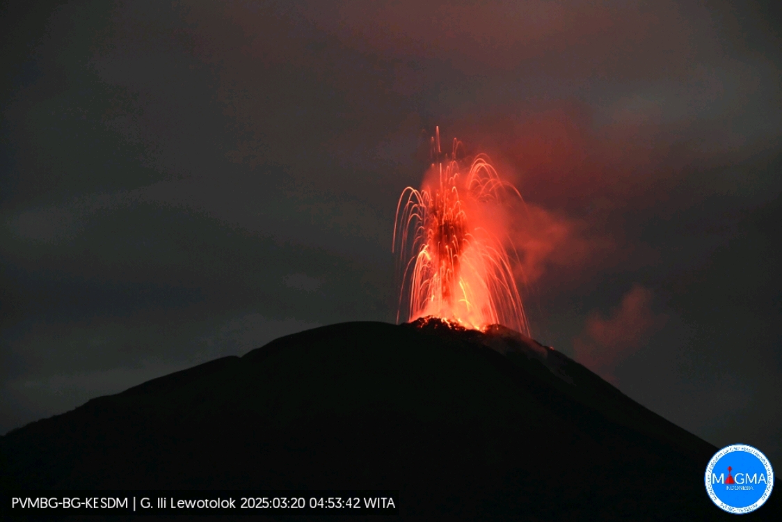
Indonesia , Ili Lewotolok :
An eruption of Mount Ili Lewotolok occurred on Thursday, March 20, 2025, at 04:54 WITA with an observed ash column height of ± 700 m above the peak (± 2123 m above sea level). The ash column was observed to be gray to black in color, with a thick intensity, oriented toward the east. This eruption was recorded on a seismograph with a maximum amplitude of 6.4 mm and a duration of 44 seconds.
The Pusat Vulkanologi dan Mitigasi Bencana Geologi (PVMBG) reported that an eruption at Lewotolok was ongoing during 12-18 March. Daily white steam-and-gas plumes rose as high as 500 m above the summit and drifted in multiple directions. At 07h00 on 14 March a white-and-gray ash plume rose about 400 m above the summit and drifted NW. At 15h15 and 15h59 on 15 March gray ash plumes rose 500 and 600 m above the summit and drifted NW and NE, respectively. Seismicity significantly increased during 16-17 March. The Alert Level remained at 2 (on a scale of 1-4) and the public was warned to stay 2 km away from the vent and 2.5 km away on the S, SE, and W flanks.
VOLCANO OBSERVATORY NOTICE FOR AVIATION – VONA
Issued : March 20 , 2025
Volcano : Ili Lewotolok (264230)
Current Aviation Colour Code : ORANGE
Previous Aviation Colour Code : orange
Source : Ili Lewotolok Volcano Observatory
Notice Number : 2025LEW011
Volcano Location : S 08 deg 16 min 19 sec E 123 deg 30 min 18 sec
Area : East Nusa Tenggara, Indonesia
Summit Elevation : 4554 FT (1423 M)
Volcanic Activity Summary :
Eruption with volcanic ash cloud at 20h54 UTC (04h54 local).
Volcanic Cloud Height :
Best estimate of ash-cloud top is around 6794 FT (2123 M) above sea level or 2240 FT (700 M) above summit. May be higher than what can be observed clearly. Source of height data: ground observer.
Other Volcanic Cloud Information :
Ash cloud moving to east. Volcanic ash is observed to be gray to dark. The intensity of volcanic ash is observed to be thick.
Remarks :
Eruption recorded on seismogram with maximum amplitude 6,4 mm and maximum duration 44 second.
Sources : Magma Indonésie. GVP.
Photo : Magma Indonésie.
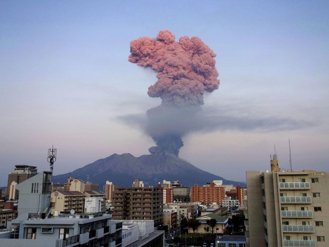
Japan , Sakurajima :
The Japan Meteorological Agency (JMA) reported ongoing eruptive activity at Minamidake Crater (Aira Caldera’s Sakurajima volcano) during 10-17 March. Nightly crater incandescence was visible in webcam images during 10-14 March. An explosion at 1706 on 11 March generated an ash plume that rose 600 m straight up above the crater rim and merged into weather clouds. The explosion ejected large blocks 600-900 m from the vent. An eruptive event at 2027 on 13 March generated an ash plume that rose 1.2 km above the crater rim and drifted SW. An eruptive event at 1757 on 16 March generated an ash plume that rose 2.2 km above the crater rim. The Alert Level remained at 3 (on a 5-level scale), and the public was warned to stay 1 km away from both the Minimadake and Showa craters.
The Aira caldera in the northern half of Kagoshima Bay contains the post-caldera Sakurajima volcano, one of Japan’s most active. Eruption of the voluminous Ito pyroclastic flow accompanied formation of the 17 x 23 km caldera about 22,000 years ago. The smaller Wakamiko caldera was formed during the early Holocene in the NE corner of the caldera, along with several post-caldera cones. The construction of Sakurajima began about 13,000 years ago on the southern rim and built an island that was joined to the Osumi Peninsula during the major explosive and effusive eruption of 1914. Activity at the Kitadake summit cone ended about 4,850 years ago, after which eruptions took place at Minamidake. Frequent eruptions since the 8th century have deposited ash on the city of Kagoshima, located across Kagoshima Bay only 8 km from the summit. The largest recorded eruption took place during 1471-76.
Sources: Japan Meteorological Agency (JMA) , GVP.
Photo : Deniss García Mendoza
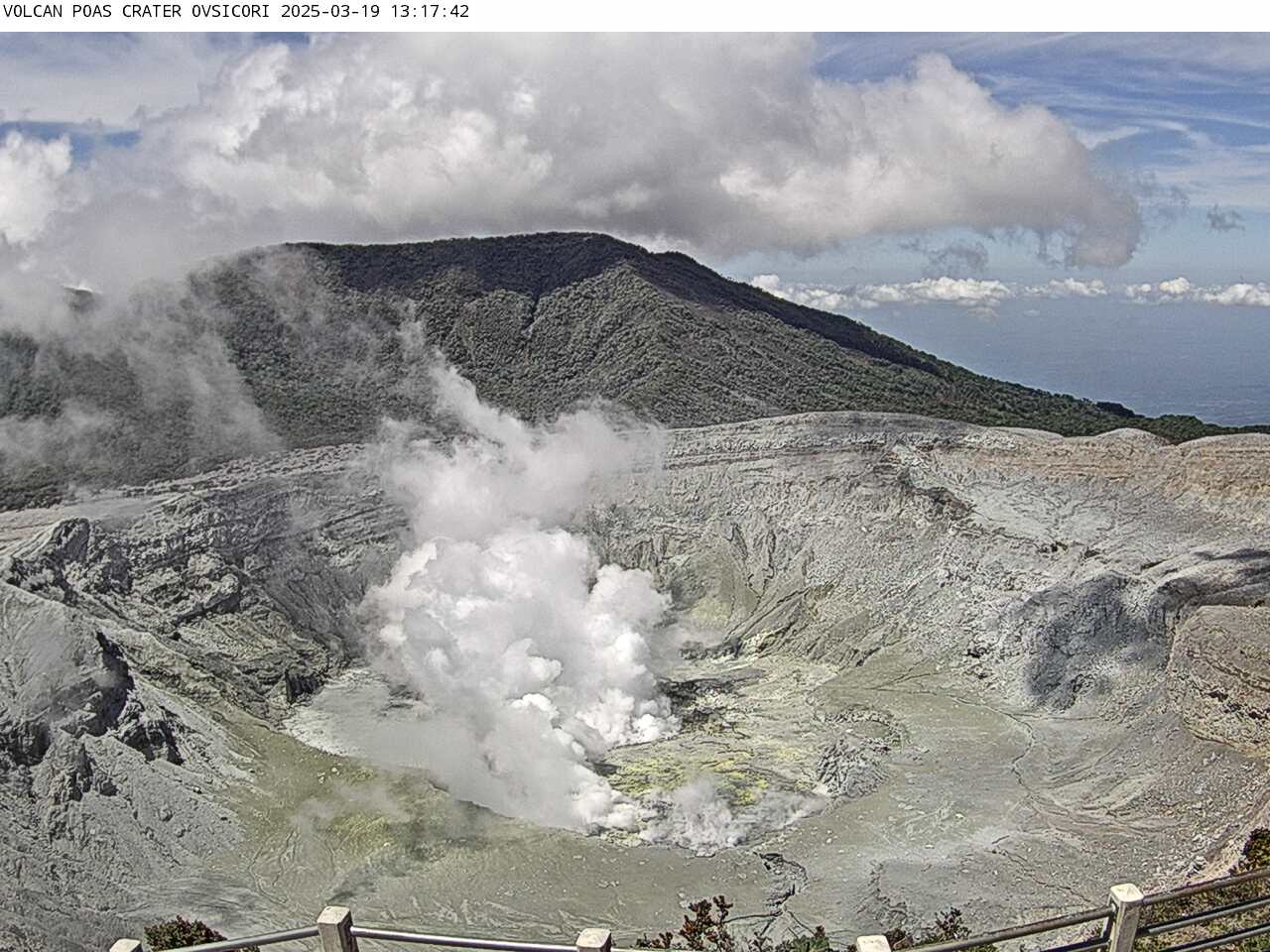
Costa Rica , Poas :
OVSICORI-UNA Statement on the Poás Volcano, Updated March 19, 2025.
OVSICORI-UNA observes:
● Increased number of seismic events in the past 24 hours.
● Increased tremor amplitude.
● Vertical deformation of crustal uplift.
● Composition and gas fluxes related to surface magma.
● Lower lake level.
● Hydrothermal system ineffective at capturing volatile substances and heat from magma.
These observations indicate an increased likelihood of eruptions that could impact visitor areas in the Poás Volcano National Park (rock bombs or falls, ash, and gas), as well as communities surrounding the Poás Volcano (ash, gas) in the coming days and weeks.
The volcano’s activity level is at CAUTION level 3 out of 4.
Seismic and Acoustic Activity
We have observed an increase in the number of high-frequency earthquakes, reaching 200 events in the last 24 hours. Prior to the January 5th eruption, an increase in this type of event was observed. However, today, the number of events is double that of January. The amplitude of the tremor has been variable in recent days, with a general upward trend.
Hyperacid Lake
From March 2017 to the present, the chemistry of the hyperacid lake has been characterized by relatively low sulfate-to-chloride ratios (between 0.6 and 1) compared to the period September 2005 – March 2017, when record values of up to 6.2 were reached. This suggests that the lake’s hyperacid waters have become saturated-supersaturated with soluble sulfur (sulfate) and chlorine (chloride) species and with solid sulfate mineral phases such as gypsum (CaSO4*2H2O). Thus, the hydrothermal lake system, with these chemical conditions and a reduced volume due to the heat input from magmatic fluids and phreatic eruptions, has lost the ability to effectively dissolve and trap magmatic gases and thermal energy.
Hyperacid Lake Level
A rise in the lake level was observed due to the eruptions of March 9, which connected the two residual lakes. In addition, the rainfall of March 16 raised the lake level.
However, despite these two phenomena, the levels of both lakes are rapidly decreasing (3 m in 3 weeks). Following the current trend, rough projections suggest a complete drying of the residual lakes probably by mid-April.
Source et photo : Ovsicori .