04 Mars 2025 .
Alaska / Aleutian Islands , Atka :
AVO/USGS Volcanic Activity Notice
Current Volcano Alert Level: NORMAL
Previous Volcano Alert Level: ADVISORY
Current Aviation Color Code: GREEN
Previous Aviation Color Code: YELLOW
Issued: Monday, March 3, 2025, 2:52 PM AKST
Source: Alaska Volcano Observatory
Notice Number: 2025/A142
Location: N 52 deg 19 min W 174 deg 8 min
Elevation: 5030 ft (1533 m)
Area: Aleutians
Volcanic Activity Summary:
There has been no further explosive activity detected at the Atka volcanic complex since the small explosive event at 4:26 UTC on February 21 (7:26 pm on 2/20/25 AKST). Since then, seismicity has remained low. Thus, the Aviation Color Code and Alert Level are being reduced to GREEN/NORMAL.
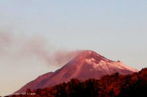
Debris mantling the upper slopes of Korovin’s active south crater. View is to the north-northwest.
Further analysis of geophysical data confirms the source of the explosion as the summit lake region of Korovin Volcano. Satellite data from February 25, 2025 shows no evidence of hot material or ash at the surface. Our interpretation is that this was a gas-driven explosion, caused by overpressure of the subsurface cap beneath the lake. This type of singular explosion is common at Korovin Volcano. Minor amounts of ash were possibly erupted in the immediate vicinity of the summit crater but have not been confirmed. Additional explosions may occur in the near future, but are unlikely.
Local seismic and infrasound sensors, and web cameras are used to monitor the Atka volcanic complex. The local sensor network is supplemented with regional infrasound and lightning networks, and satellite data.
Remarks:
The Atka volcanic complex forms the northern part of Atka Island, located about 16 km north of the community of Atka and 1,761 km southwest of Anchorage. The Atka volcanic complex includes a possible older caldera and several younger vents, including Korovin Volcano, Mount Kliuchef, and Sarichef Volcano. Korovin Volcano, a 1553-m-high (5030 ft) stratovolcano, has been the site of most historical volcanic activity, and has a small, roiling crater lake that occasionally produces energetic steam emissions. Korovin has erupted several times in the past 200 years, including 1973, 1987, and 1998, and has likely had small ash emissions as recently as 2005. Typical recent Korovin eruptions produce minor amounts of ash and occasional but small lava flows. Reports of the height of the ash plume produced by the 1998 eruption ranged as high as 10,600 m (35,000 feet) above sea level. Mount Kliuchef is composed of a series of five vents aligned northeast–southwest. The two main summit vents of Kliuchef appear relatively young and the easternmost was probably the source of an 1812 eruption that is sometimes attributed to Sarichef.
Source : AVO
Photo : McGimsey, R. G. / Alaska Volcano Observatory / U.S. Geological Survey ( 2004)
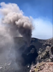
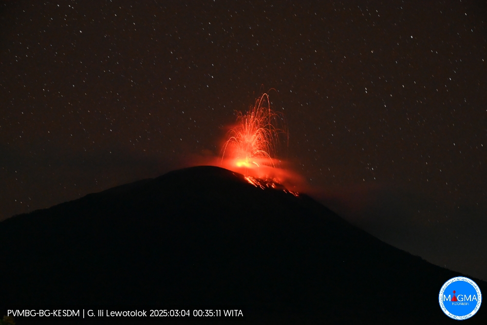
Indonesia , Ili Lewotolok :
An eruption of Mount Ili Lewotolok occurred on Tuesday, March 4, 2025 at 00:35 WITA. No images of the eruption were observed. This eruption was recorded on a seismograph with a maximum amplitude of 9.7 mm and a duration of 73 seconds.
Seismicity observation
42 Eruption earthquakes with an amplitude of 7 to 10.9 mm and a duration of 23 to 212 seconds.
1 avalanche earthquake with an amplitude of 1.5 mm and a duration of 251 seconds.
100 Emission earthquake with an amplitude of 1 to 10.1 mm and a duration of 18 to 60 seconds.
1 harmonic tremor with an amplitude of 1.4 mm and an earthquake duration of 178 seconds.
1 shallow volcanic earthquake with an amplitude of 1.1 mm and a duration of 6.5 seconds.
3 Deep volcanic earthquakes with an amplitude of 2.2 to 14 mm, and an earthquake duration of 11 to 14 seconds.
2 Distant tectonic earthquakes with amplitude 1.4-2 mm, and earthquake duration 143-178 seconds.
Recommendation
At activity level II (alert), it is recommended:
The community around Mount Ili Lewotolok and visitors/climbers/tourists should not enter or conduct activities within a 2 km radius of the activity center of Mount Ili Lewotolok, and the community of Lamatokan village and Jontona village should always be aware of the potential threat of avalanche/landslide/lahar hazard from the eastern part of the peak/crater of Mount Ili Lewotolok.
Source et Photo : Magma Indonésie .
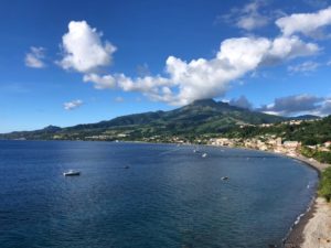
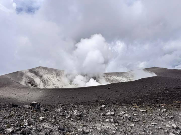
Colombia , Puracé :
Volcanic activity continues in the crater of the volcano with the emission of gases and vapors, as well as fumaroles. According to the Colombian Geological Survey, these are typical low-energy events, so the yellow alert is maintained.
Recently, a group of officials from the Colombian Geological Survey (SGC), the National Risk Management Unit (UNGRD) and the Government of Cauca reached the crater of the Puracé volcano, where an increase in seismic activity was recorded in early February 2025.
According to the most recent analysis of the volcano’s behavior by the SGC, the current records in the Coconucos range, where the Puracé volcano is located, are typical of low-energy events. For this reason, the volcano remains on yellow alert.
“Direct vision allowed us to compare the information from our monitoring with data from communities in the area of influence. The records of gas emissions, volcano temperatures, seismic activity and fractures allow us to technically conclude that a change in vigilance is not necessary soon,” said Julio Fierro Morales, director of the Colombian Geological Survey.
During the visit, it was evident that volcanic activity continues in the crater of the Puracé volcano, where emissions of gas and vapors were observed, as well as fumaroles; normal elements in the yellow alert state.
“Although we are on yellow alert, this is an active volcanic chain. Therefore, our obligation is to prepare for events that may occur. For this, we are implementing the National Plan for Preparedness and Response to the Activity of the Puracé Volcano,” said Carlos Carillo, director of the UNGRD.
Source : Elespectador com.
Photos : Carlos Carillo via Wulkany swiatia / FB
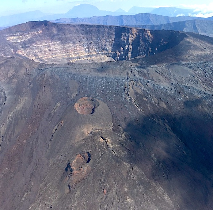
La Réunion , Piton de la Fournaise :
Foreword
The observatory and its network of stations were particularly impacted by the passage of Cyclone Garance over the island on February 28, 2025 (red alert throughout the territory of Reunion from February 27, 7 p.m. to March 1, 10 a.m., including a purple alert on February 28 from 9 a.m. to 12 p.m.).
During the cyclone’s passage over the volcano, the OVPF-IPGP lost contact with a large part of its network.
At noon on February 28, the following were out of service or inaccessible:
– 79% of seismic stations,
– 89% of GNSS stations,
– 90% of inclinometer stations,
– 100% of extensometer stations,
– 75% of geochemistry stations,
– 90% of webcams.
The OVPF-IPGP nevertheless managed to maintain minimal operational monitoring of volcanic activity throughout the cyclone, despite a « degraded mode ». A complete assessment of the damage will be made in the next bulletin, when all the reconnaissances have been made on the volcano and the transmission networks repaired.
Seismicity
In February 2025, the OVPF-IPGP recorded in the Piton de la Fournaise massif in total:
• 13 superficial volcano-tectonic earthquakes (0 to 2.5 km above sea level) under the summit craters;
• 5 deep earthquakes (below sea level);
• 4 long-period earthquakes;
• 273 landslides.
The month of February 2025 was marked by low seismicity under the Piton de la Fournaise with only 13 superficial volcano-tectonic earthquakes and 5 deep earthquakes recorded.
Only 3 superficial volcano-tectonic earthquakes and 2 deep earthquakes could be located respectively under the Dolomieu crater, to the northwest of the Bory crater and under the eastern flank. The others – of lower magnitudes – could not be located.
Numerous (273) landslides in the Dolomieu Crater, at the level of the ramparts of the Enclos Fouqué and at the Cassé de la Rivière de l’Est were also recorded
Summary
Since April 2024, the replenishment of magma and the pressurization of the superficial reservoir have ceased.
In February 2025, seismicity remained low with only 14 superficial volcano-tectonic earthquakes and 5 deep earthquakes recorded. A slight summit deflation and a drop in CO2 concentrations in the soil are still observed.
Source et photo : OVPF/IPGP
Costa Rica , Turrialba :
ERUPTION REPORT – OVSICORI-UNA
Location: N10.02 W83.76
Height of the Massif: 3325mts. (10906 feet)
Date: 03/03/2025 Time: 9:33
Height of the plume (above the crater):
328 feet (100 meters)
Source of observation of the plume:
Eruption recorded by seismographs and webcam.
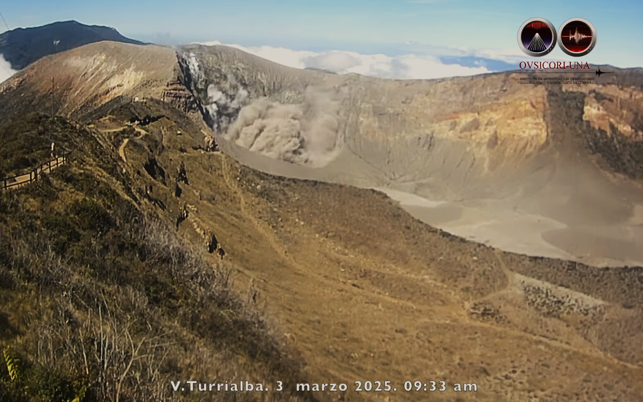
Observed Activity:
Small ash eruption lasting 15 seconds in the West Crater. The eruptive column was about 100 meters high from the crater floor.
The eruptive plume is gray in color. The wind dispersed the plume of ash, gas and aerosols towards the southwest. There are no reports of ash fall at the time of writing. Turrialba has emitted small amounts of ash in recent days and so far.
Activity Level:
Warning
Source : Ovsicori
Photo : Capture d’écran 4 Mars 2025