January 18 , 2025 .
Hawaii , Kilauea :
Friday, January 17, 2025, 8:55 AM HST (Friday, January 17, 2025, 18:55 UTC)
19°25’16 » N 155°17’13 » W,
Summit Elevation 4091 ft (1247 m)
Current Volcano Alert Level: WATCH
Current Aviation Color Code: ORANGE
Activity Summary:
The summit eruption at Kīlauea volcano that began on December 23 entered its fourth eruptive episode on January 15 and continues this morning. All eruptive activity remains confined within Kaluapele (the summit caldera), although persistent fountaining coupled with Kona winds has resulted in Pele’s hair reported in some public areas within the National Park and in nearby communities. No unusual activity has been noted along Kīlauea’s East Rift Zone or Southwest Rift Zone.
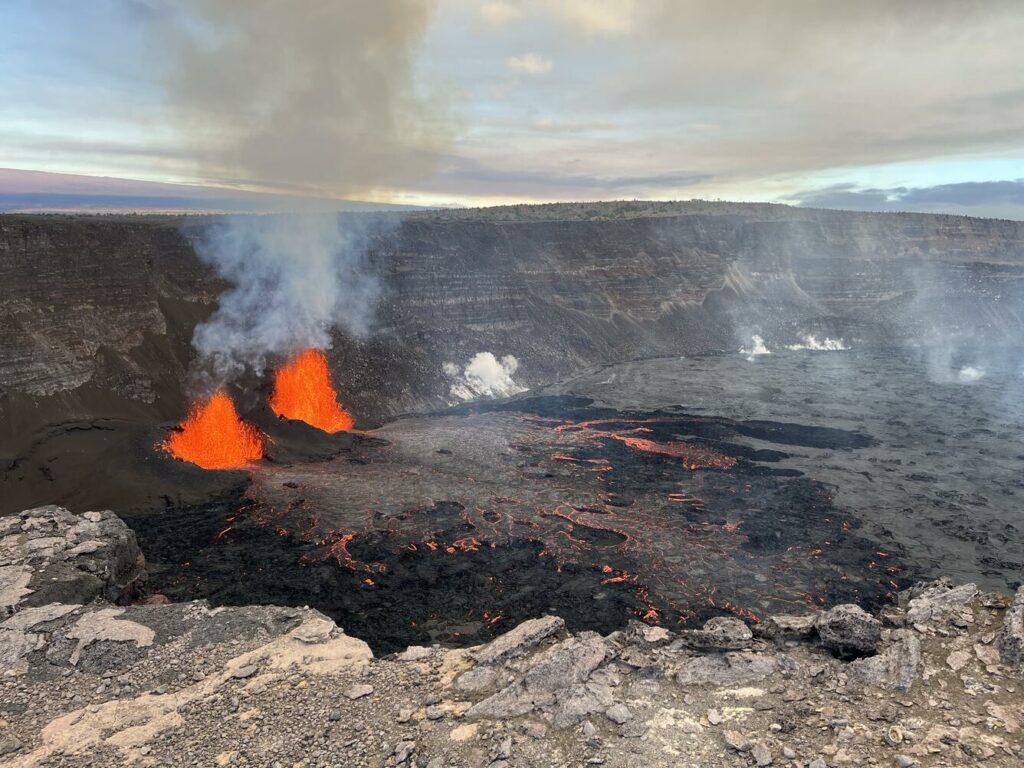
View of the Kīlauea summit eruption in Hawaiʻi Volcanoes National Park, from the south rim of the caldera. The caldera wall behind the erupting vents is approximately 210 meters (690 feet) tall. This morning, USGS Hawaiian Volcano Observatory field crews reported lava fountain heights of 50 meters (160 feet) and 40 m (140 feet) from north and south vents, respectively. At about 8:25 a.m. this morning, field crews reported that parts of the south vent collapsed, with an associated reduction of about half in south vent lava fountain height. Lava flow activity has remained confined to the southwest crater floor area near the active vents.
Summit Eruption Observations:
The summit eruption at Kīlauea volcano that began on December 23 entered its fourth eruptive episode (Episode 4) the morning of January 15, and continues. Activity is concentrated at two lava fountains in southwest Kaluapele that have each built up a cone and have associated lava flows. As of this morning, both cones are 30 to 35 meters tall (100 to 115 feet), and field crews report that the current fountaining is generally the height of the cones, with occasional fountaining to 40 to 45 meters (130 to 150 feet). There have been lava ooze-outs overnight on the crater floor in areas that covered by lava during earlier episodes of the current eruption. Over the past 24 hours, persistent lava fountaining, coupled with Kona wind conditions, has resulted in Pele’s hair falling on nearby communities, along with tephra fall at Uekahuna Overlook and within the closed area of the National Park. There have been reports of Pele’s hair near Uekahuna Overlook, the Kīlauea Visitor’s Center, the Volcano Golf Course subdivision, Volcano Village, and Ohia Estates; other areas and communities may also be affected .
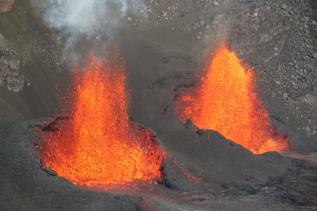
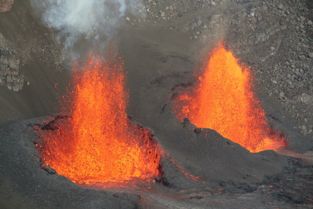
This zoom view of the two active lava fountains within Halema‘uma‘u at the summit of Kīlauea was captured by USGS Hawaiian Volcano Observatory geologists during an observational visit to the southern crater rim on the morning of January 16, 2025. The geologists measured the northern (right) and southern (left) fountains to be consistently 165 feet (50 meters) and 130 feet (40 meters) tall, respectively, with both having built spatter cones that stood about 100 feet (30 meters) tall by that point.
Summit Instrumental Observations:
Seismic tremor remains elevated during this period of lava fountaining but has remained constant over the past 24 hours. Seismicity in the summit region remains low, with only 1 small earthquake (below M2.0) detected in the past 24 hours. Summit tiltmeters continue to record deflation, which started soon after the start of Episode 4. The most recently measured sulfur dioxide (SO2) emission rate was approximately 560 tonnes per day Monday, January 14, before the start of Episode 4. Current Kona wind conditions are not favorable for obtaining accurate SO2 emission rate measurements. Emissions during the current fountaining are likely to be on the order 10,000 tonnes per day or more; the resulting hazard will be affected by wind conditions
Rift Zone Observations:
Seismicity remains low in both the East Rift Zone and Southwest Rift Zone, with counts of shallow earthquakes at background levels. The ESC tiltmeter in the upper East Rift Zone has recorded minor inflation since the start of Episode 4 at the summit. Deformation rates remain low in the middle and lower East Rift Zone and in the Southwest Rift Zone, as recorded by GPS instruments and tiltmeters.
Source : HVO
Photo : USGS / K. Lynn , USGS / M. Zoeller.
Indonesia , Merapi :
MOUNT MERAPI ACTIVITY REPORT, January 10-16, 2025 .
OBSERVATION RESULT
Visual
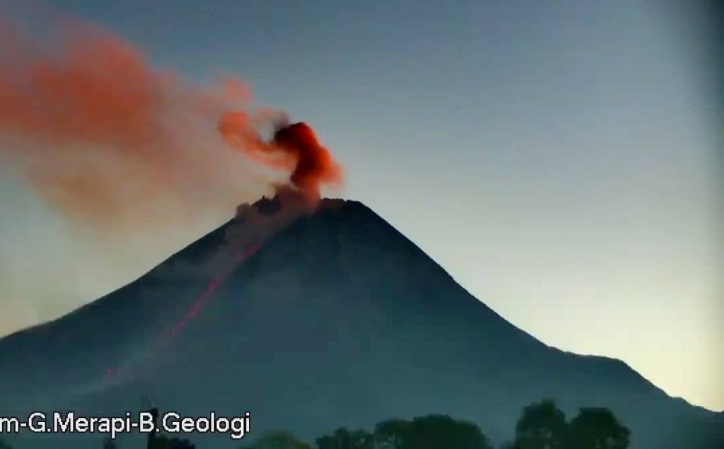
The weather around Mount Merapi is generally sunny in the morning and night, while during the day and evening it is hazy. White smoke, thin to thick, low to moderate pressure, and 400 m high was observed from Mount Merapi Observation Post Kaliurang on January 14, 2025 at 05:06 . This week, lava avalanches were observed 29 times in the southwest (upstream of the Bebeng River) up to a maximum distance of 1,900 m, 12 times upstream of the Krasak River up to a maximum distance of 1,900 m, and 13 times in the west (upstream of the Sat/Putih River) up to a maximum distance of 1,700 m. m. The morphology of the southwest dome was observed to have changed due to lava flow activity. For the central dome, no significant morphological changes were observed. According to the analysis of aerial photos dated January 4, 2025, the volume of the southwest dome was measured at 3,505,900 m3. The central dome, on the other hand, measures 2,360,700 m3.
Seismicity
This week, the seismicity of Mount Merapi recorded:
728 Multiphase Earthquakes (MP),
968 Avalanche Earthquakes (RF)
15 Tectonic Earthquakes (TT).
The intensity of earthquakes this week was lower than last week.
Deformation
The deformation of Mount Merapi monitored using EDM and GPS this week showed no significant changes.
Rainfall and Lahars
This week, it rained at Mount Merapi observation post with the highest rainfall intensity of 61 mm/hour for 85 minutes at Kaliurang post on 15 January 2025 and there was a report of an increase in the discharge of the Trising and Krasak rivers.
Conclusion
Based on the results of visual and instrumental observations, it is concluded that:
The volcanic activity of Mount Merapi is still quite high in the form of effusive eruptions. The activity status is defined at the « SIAGA » level.
Source : BPPTKG
Photo : Frekom ( archive)
Iceland , Grjótárvatn :
Earthquakes continue to be recorded at great depths near Grjótárvatn. M3.2 earthquake recorded yesterday morning
Update 17. January 14:00 UTC
Nearly 100 earthquakes above M1.0 recorded in January
M3.2 earthquake recorded yesterday, the largest in the area since activity increased in August 2024
Magma intrusion at depth considered the most likely cause of seismic activity
No indications that magma is moving towards the surface
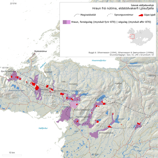
Ljósofjall volcanic system, modern lava and scoria formations. // Ljósufjöll volcanic system, Holocene lava flows and scoria deposits.
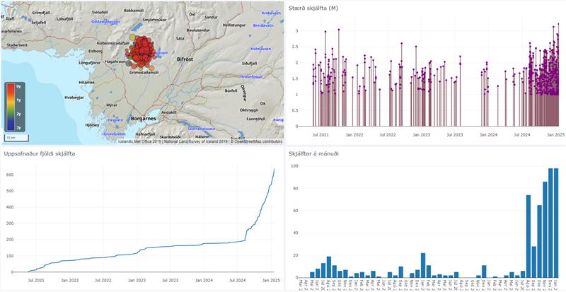
Seismic activity continues to increase near Grjótárvatn. So far in January, nearly 100 earthquakes above M1.0 have been recorded. This is comparable to the total number of earthquakes in December 2024, which was the highest monthly count ever recorded in the area.
Yesterday morning, on January 16, an M3.2 earthquake was detected. No reports have been received by the Icelandic Meteorological Office indicating that the earthquake was felt in inhabited areas, though residents in nearby regions may have noticed it. This was the largest earthquake recorded in the area since activity began increasing in August 2024; previously, an M3.1 earthquake was recorded on December 18, 2024.
Composite image from the IMO’s earthquake visualization tool, showing activity near Grjótárvatn from July 2021 to January 2025. The upper left map shows earthquake locations. The upper right graph displays earthquake magnitudes. The lower left graph shows the cumulative number of earthquakes, while the lower right graph illustrates the monthly earthquake count.
On January 2, a tremor episode lasting about an hour was recorded. Since then, one additional tremor episode occurred on January 10, also lasting just over an hour.
News about this activity was published on January 9 reviewing the activity, highlighting that the earthquakes exhibit an unusually high b-value. This is often associated with earthquakes in volcanic areas and indicates a relatively high proportion of small earthquakes. The most likely explanation for this seismic activity is believed to be magma intrusion at depth rather than tectonic movements. However, current monitoring data show no indications that magma is moving towards the surface.
The Icelandic Meteorological Office continues to monitor the activity closely and is working on a new monitoring plan for the area. This includes plans to increase the number of instruments to improve surveillance and gain a clearer understanding of the development and causes of the activity.
Source et photos : IMO
Indonesia , Ibu :
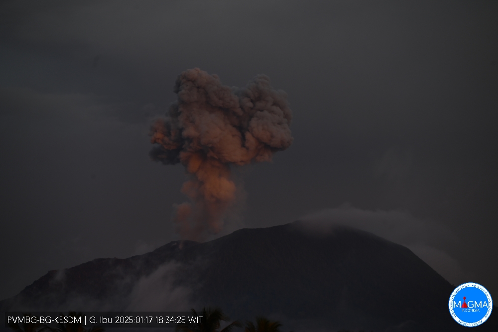
An eruption of Mount Ibu occurred on Friday, 17 January 2025, at 18:33 WIT with an observed ash column height of ± 600 m above the peak (± 1925 m above sea level). The ash column was observed to be grey in colour with a thick intensity, oriented towards the West. This eruption was recorded on a seismograph with a maximum amplitude of 28 mm and a duration of 72 seconds.
The explosions follow one after the other.
VOLCANO OBSERVATORY NOTICE FOR AVIATION – VONA
Issued : January 17 , 2025
Volcano : Ibu (268030)
Current Aviation Colour Code : ORANGE
Previous Aviation Colour Code : orange
Source : Ibu Volcano Observatory
Notice Number : 2025IBU088
Volcano Location : N 01 deg 29 min 17 sec E 127 deg 37 min 48 sec
Area : North Maluku, Indonesia
Summit Elevation : 4240 FT (1325 M)
Volcanic Activity Summary :
Eruption with volcanic ash cloud at 09h33 UTC (18h33 local).
Volcanic Cloud Height :
Best estimate of ash-cloud top is around 6160 FT (1925 M) above sea level or 1920 FT (600 M) above summit. May be higher than what can be observed clearly. Source of height data: ground observer.
Other Volcanic Cloud Information :
Ash cloud moving to west. Volcanic ash is observed to be gray. The intensity of volcanic ash is observed to be thick.
Remarks :
Eruption recorded on seismogram with maximum amplitude 28 mm and maximum duration 72 second.
Source et photo : Magma Indonésie.
Nicaragua , Telica :
Telica Volcano Records 126 Explosions; Low-Intensity Activity, INETER Reports
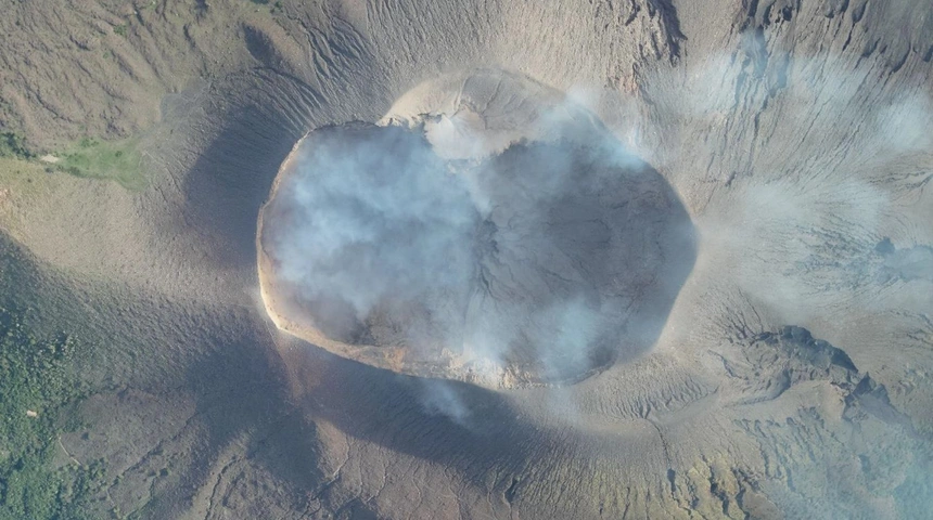
The Telica Volcano is experiencing low-intensity activity, with 126 explosions reported since Saturday. An inter-agency team used drones equipped with thermal sensors to monitor the crater and concluded that no increase in activity was expected.
The Nicaraguan Institute of Territorial Studies (INETER) reported a total of 126 explosions at the Telica Volcano since last Saturday. This information was revealed on Wednesday by Rosario Murillo, who presented a report based on the results of monitoring carried out by an inter-agency team.
This work team was made up of technicians from the Telica Municipal Risk Management Unit, specialists in unmanned means from Civil Defense, personnel from the Ministry of Health (MINSA), INETER and the National System for Prevention, Mitigation and Attention to Disasters (SINAPRED).
According to preliminary results, volcanic activity is characterized by constant incandescence in the main crater and the expulsion of ash and rock blocks, which have been limited to a radius of about one kilometer southwest of the crater. No signs of major changes have been observed in the internal structure of the volcano, indicating the absence of more complex events.
Rosario Murillo also explained that the drones used in the surveillance have high-range thermographic sensors and high-resolution thermal and digital cameras. During the flights, temperatures of up to 500ºC were recorded in the main crater, an incandescence that has remained constant since December 2015.
« An incandescence is also observed in the main crater with temperatures of around 500 degrees Celsius; this incandescence has been maintained since December of last year until today. Preliminarily, it is also observed that there are no relevant changes in the volcanic structure, which » « This could be an indication that there is no more complex or higher risk activity, » concluded Rosario Murillo.
Source et photo : 100% Noticias.

