February 27 , 2024.
Kamchatka , Sheveluch :
VOLCANO OBSERVATORY NOTICE FOR AVIATION (VONA)
Issued: February 27 , 2024
Volcano: Sheveluch (CAVW #300270)
Current aviation colour code: ORANGE
Previous aviation colour code: orange
Source: KVERT
Notice Number: 2024-10
Volcano Location: N 56 deg 38 min E 161 deg 18 min
Area: Kamchatka, Russia
Summit Elevation: 3283 m (10768.24 ft), the dome elevation ~2500 m (8200 ft)
Volcanic Activity Summary:
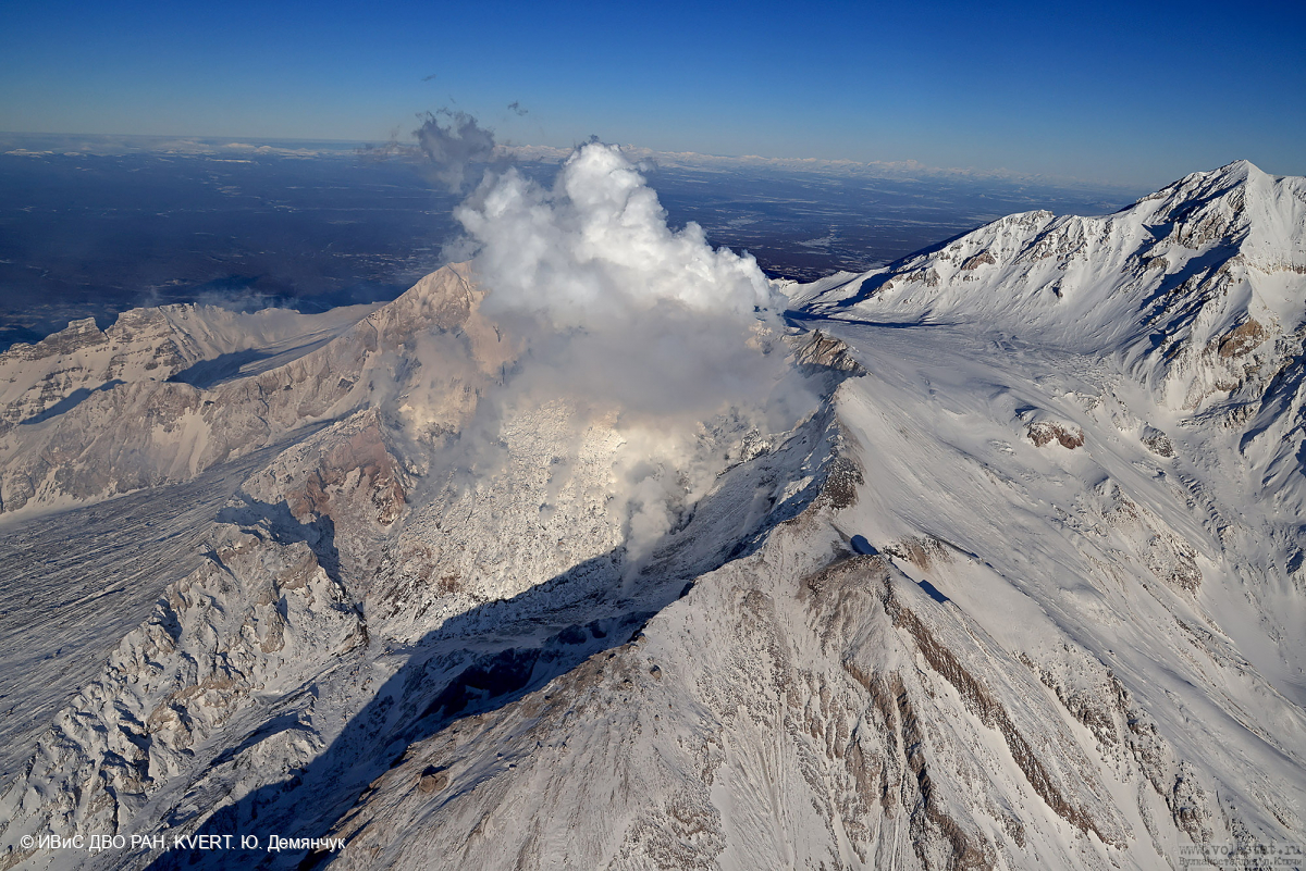
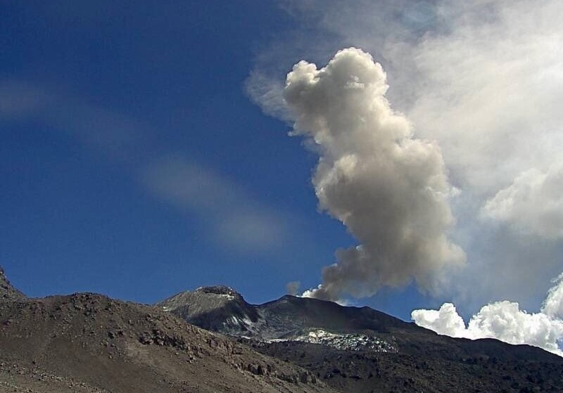
Video and satellite data by KVERT shows a strong wind lifts ash from the southern slopes of Sheveluch volcano, and a plume of resuspended ash is extending about 96 km to the eastsouth-east of the volcano.
An extrusive-effusive eruption of the volcano continues. A danger of ash explosions up to 6 km (19,700 ft) a.s.l. remains. Ongoing activity could affect low-flying aircraft.
Volcanic cloud height:
2500-3000 m (8200-9840 ft) AMSL Time and method of ash plume/cloud height determination: 20240227/0235Z – Video data
Other volcanic cloud information:
Distance of ash plume/cloud of the volcano: 96 km (60 mi)
Direction of drift of ash plume/cloud of the volcano: ESE / azimuth 113 deg
Time and method of ash plume/cloud determination: 20240227/0210Z – Himawari-9 14m15
Source : Kvert
Photo : Yu. Demyanchuk. IVS FEB RAS, KVERT
Indonesia , Semeru :
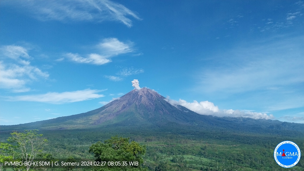
Semeru exhibited an eruption on Monday, February 26, 2024 at 11:12 p.m. WIB with the height of the ash column observed at ± 700 m above the summit (± 4,376 m above sea level). The ash column was observed to be white to gray in color with thick intensity, oriented towards the West. This eruption was recorded on a seismograph with a maximum amplitude of 22 mm and a duration of 101 seconds.
VOLCANO OBSERVATORY NOTICE FOR AVIATION – VONA
Issued : February 26 , 2024
Volcano : Semeru (263300)
Current Aviation Colour Code : ORANGE
Previous Aviation Colour Code : orange
Source : Semeru Volcano Observatory
Notice Number : 2024SMR142
Volcano Location : S 08 deg 06 min 29 sec E 112 deg 55 min 12 sec
Area : East java, Indonesia
Summit Elevation : 11763 FT (3676 M)
Volcanic Activity Summary :
Eruption with volcanic ash cloud at 23h12 UTC (06h12 local).
Volcanic Cloud Height :
Best estimate of ash-cloud top is around 14003 FT (4376 M) above sea level or 2240 FT (700 M) above summit. May be higher than what can be observed clearly. Source of height data: ground observer.
Other Volcanic Cloud Information :
Ash cloud moving to southwest. Volcanic ash is observed to be gray. The intensity of volcanic ash is observed to be thick.
Remarks :
Eruption recorded on seismogram with maximum amplitude 22 mm and maximum duration 101 second.
Source et photo : Magma Indonésie .
Peru , Sabancaya :
Analysis period: from February 19, 2024 to February 25, 2024, Arequipa, February 26, 2024
Alert level: ORANGE
The Geophysical Institute of Peru (IGP) reports that the eruptive activity of the Sabancaya volcano remains at moderate levels, that is, with the recording of an average of 30 daily explosions, with columns of ash and of gas up to 1800 m altitude above the summit of the volcano. Consequently, the volcanic alert level remains at the ORANGE level
The IGP recorded and analyzed the occurrence of 253 earthquakes of volcanic origin, associated with the circulation of magmatic fluids inside the Sabancaya volcano, as well as earthquakes linked to the fracturing of rocks. An average of 30 explosions were recorded daily.
Columns of ash and gas have been observed at an altitude of up to 1800 m above the summit of the volcano. The predominant direction of these emissions was towards the North, South, North-West, South-East and South-West sectors of the volcano over a distance of less than 10 KM.
We continue to record a slight inflation process in the northern sector (around the Hualca Hualca volcano).
Satellite recordings identified the presence of 10 thermal anomalies, with a maximum value of 11 MW, associated with the presence of a lava body on the surface of the volcano crater.
Moderate emissions (749 tonnes/day) of sulfur dioxide (SO2) were observed.
RECOMMENDATIONS
• Keep the volcano alert level in orange.
• Do not approach within a radius of less than 12 km from the crater.
Source : Cenvul
Photo : Ingemmet
Guatemala , Santiaguito :
Weather conditions: partly cloudy
Wind: North-East
Precipitation: 0.0 mm.
Activity:
The Observatory reports activity on the Caliente dome, with moderate and continuous degassing in the southwest, west and south directions. There were 3 to 7 explosions per hour. Moderate explosions raise columns of water vapor and ash to heights of up to 3,400 m (10,498 ft) and cause short-distance pyroclastic flows mainly down the eastern and southeastern flanks. .
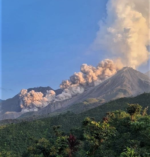
Detachment of boulders from the dome and the edges of the lava flow occasionally continues. Heavy avalanches and audible sounds of volcanic activity are possible. Activity remains at a high level, so there remains the possibility that with explosions or under the effect of gravity, part of the accumulated materials collapse and pyroclastic flows over long distances are generated towards the South. West, South, South-East and East.
Source : Insivumeh.
Photo : Edgar Cabrera / CONRED
Alaska , Great Sitkin :
Satellite radar data through February 24, 2024 show that slow eruption of lava in the summit crater of Great Sitkin Volcano continues. Seismicity was low over the past day with a few earthquakes observed. No activity was observed in cloudy satellite and webcam images over the past day.
The current lava flow began erupting in July 2021. No explosive events have occurred since a single event in May 2021.
Local seismic and infrasound sensors and web cameras are used to monitor Great Sitkin along with regional infrasound and lightning networks and satellite data.
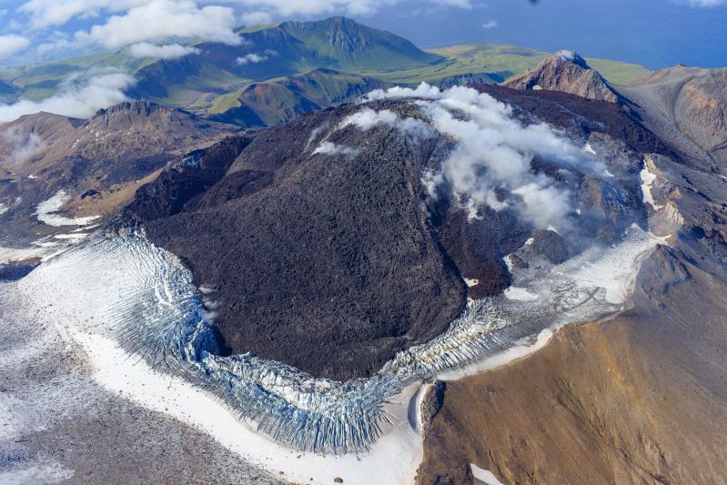
The Great Sitkin volcano forms much of the northern side of Great Sitkin Island. A younger parasitic volcano capped by a small, 0.8 x 1.2 km ice-filled summit caldera was constructed within a large late-Pleistocene or early Holocene scarp formed by massive edifice failure that truncated an ancestral volcano and produced a submarine debris avalanche. Deposits from this and an older debris avalanche from a source to the south cover a broad area of the ocean floor north of the volcano. The summit lies along the eastern rim of the younger collapse scarp. Deposits from an earlier caldera-forming eruption of unknown age cover the flanks of the island to a depth up to 6 m. The small younger caldera was partially filled by lava domes emplaced in 1945 and 1974, and five small older flank lava domes, two of which lie on the coastline, were constructed along northwest- and NNW-trending lines. Hot springs, mud pots, and fumaroles occur near the head of Big Fox Creek, south of the volcano. Historical eruptions have been recorded since the late-19th century.
Sources : AVO , GVP.
Photo : Loewen, Matt / Alaska Volcano Observatory / U.S. Geological Survey.