December 02 , 2021.
Italy , Stromboli :
Weekly bulletin from November 22, 2021 to November 28, 2021 (issue date November 30, 2021)
SUMMARY STATUS OF THE ACTIVITY
In view of the monitoring data, it is highlighted:
1) VOLCANOLOGICAL REMARKS:
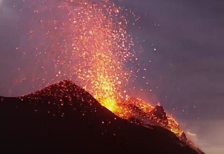
During this period, normal strombolian-type explosive activity was observed with splash activity and lava flow originating from the North crater area. The total hourly frequency of explosions fluctuated between medium and medium-high values (10-20 events / h). The intensity of the explosions varied from low to high in the North crater area and from low to medium in the Center-South crater area.
2) SEISMOLOGY:
The seismological parameters monitored do not show any significant changes, with the exception of the occurrence of the lava overflow of 25/11.
3) DEFORMATIONS:
The island’s soil deformation monitoring networks have shown no significant changes over the past week.
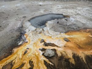
4) GEOCHEMISTRY: The flow of SO2 is at an average level. The CO2 flux values recorded at Pizzo Sopra La Fossa are at high levels.
The value of the isotopic ratio of Helium dissolved in the thermal aquifer of Stromboli has further increased compared to the previous sampling in October. The ratios are at high values.
5) SATELLITE OBSERVATIONS:
The thermal activity observed by satellite showed moderate anomalies only in correspondence with the effusive event of November 26.
VOLCANOLOGICAL OBSERVATIONS
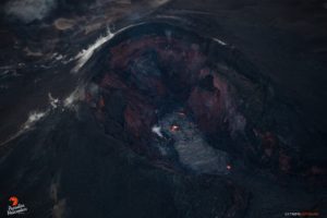
During the observation period, the eruptive activity of Stromboli was characterized by the analysis of the images recorded by the surveillance cameras of the INGV-OE (altitude 190m, Punta Corvi, altitude 400m and Pizzo). The explosive activity was mainly produced by 5 (five) eruptive chimneys located in the North crater area and 4 (four) eruptive chimneys located in the Center-South crater area. All the vents are located inside the depression which occupies the terrace of the crater.
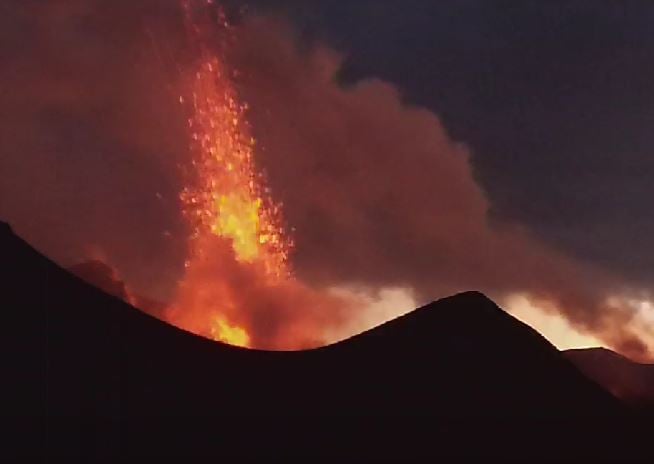
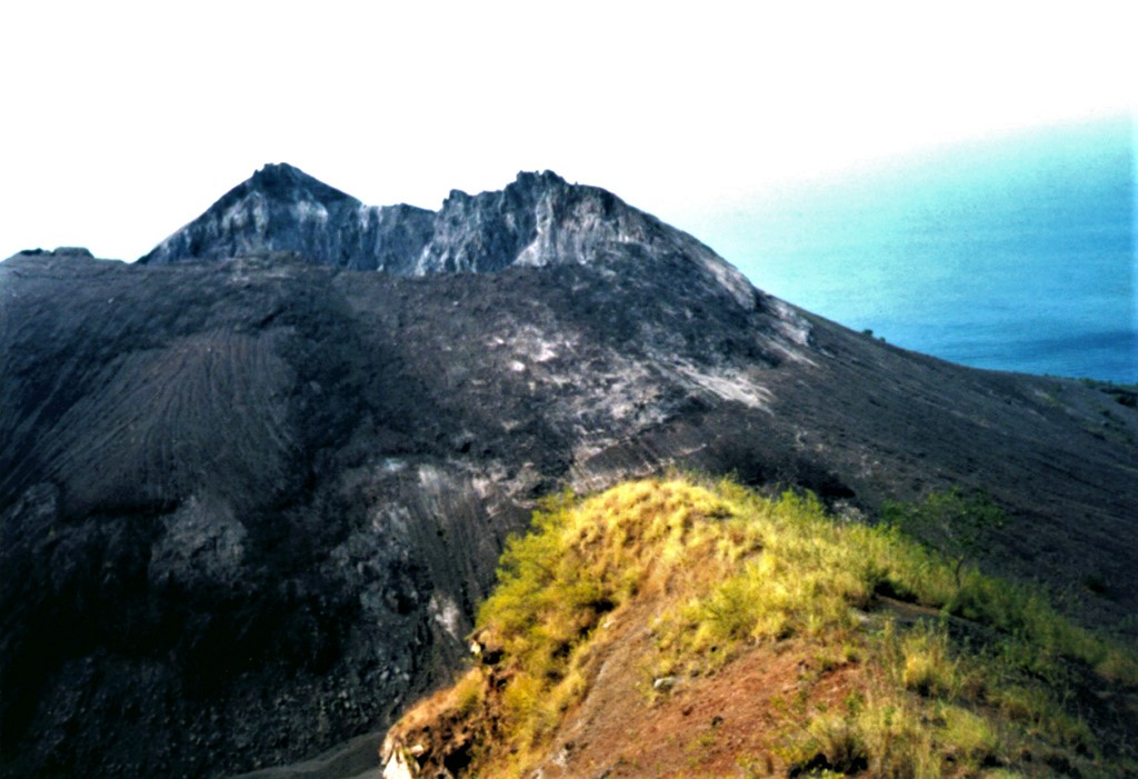
In the period from November 25 to 27, a modest lava flow from the northern area of the crater terrace was observed.
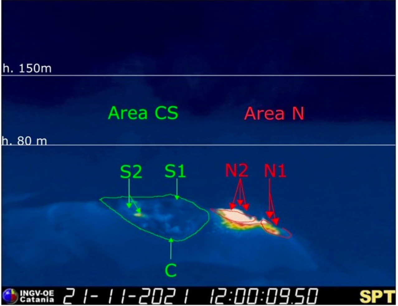
The crater terrace seen by the thermal camera placed on Pizzo above the Fossa with the delimitation of the zones of the crater Center-South Zone and North Zone (ZONE N, ZONE C-S respectively). Abbreviations and arrows indicate the names and locations of active vents, the area above the crater terrace is divided into three height ranges relating to the intensity of the explosions.
Sector N1, with two emission points, located in the area of the North crater produced explosions of mainly medium-low intensity (sometimes the products of the explosions exceeded 80 m in height) emitting coarse materials (lapilli and bombs) . Sector N2, with three emission points, exhibited explosive activity of varying intensity from low (less than 80 m in height) to high (products exceeded 150 m in height) emitting coarse materials with splashing activity intense pulses. The average frequency of explosions varied from 6 to 17 events / h.
In the Center-South zone, sectors S1 and C did not show significant explosive activity, while the two vents located in sector S2 produced explosions, even simultaneously, of medium-low intensity (sometimes the explosive products exceeded 80 m in height) emitting coarse materials. The frequency of the explosions varied from 4 to 8 events / h.
Description of the effusive event for the period 25-27 November 2021
The morning of November 25 from 06:51 UTC begins an intense rolling of lava blocks which branch off from the hornito of sector N2 of the area of the North crater overlooking the Sciara del Fuoco. In the following hours, an increasing number of erupting products show a lava flow which reaches the upper zone of the Sciara before tilting and producing blocks which roll along the Sciara reaching for a small minimum part the coastline (. The effusion rate of the lava flow was discontinuous, alternating longer emission time intervals such as the night of November 25-26 when many boulders reached the shoreline. On the evening of November 27, the lava flow showed blocks that broke away from the flow as it cooled.
Source : INGV.
Photos : Webcam.
Spain / La Palma , Cumbre Vieja :
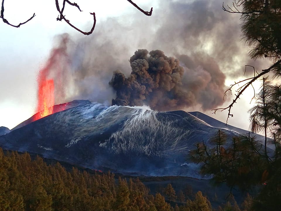
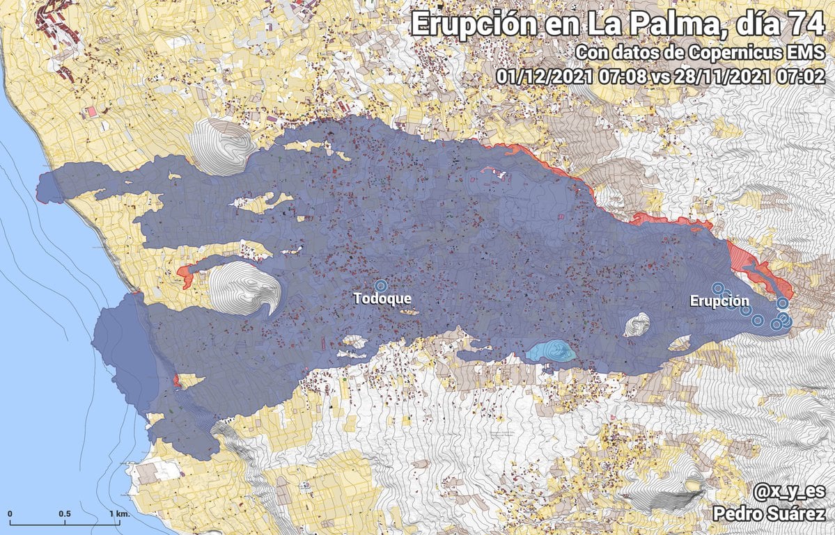
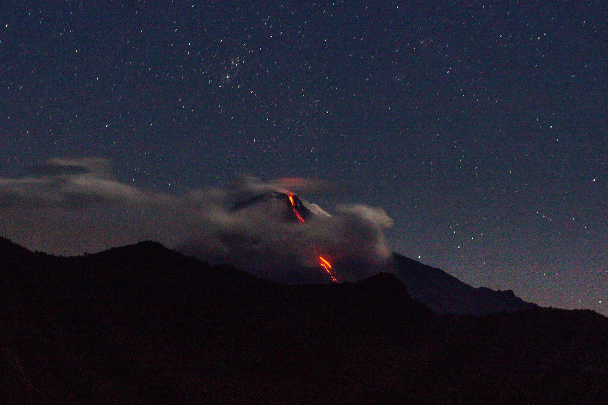
01 December 2021, 09:00 UTC. Eruptive activity continues on La Palma.
Since the last declaration, a total of 341 earthquakes have been located in the area affected by the volcanic reactivation on the island of La Palma, 12 of which were felt by the population.
Seismicity continues below the central area of Cumbre Vieja in the same areas of the previous days, 334 of these earthquakes are located at depths of 8-17 km and the rest (7) at depths of 20 km.
The maximum recorded magnitude is 4.8 (mbLg) corresponding to yesterday’s earthquake at 13:04 UTC, with a depth of 37 km and an intensity IV (EMS98).
The amplitude of the tremor signal was maintained at average levels with intensifying pulses.
The island’s network of permanent GNSS stations does not show a clear trend in the deformation of the stations closest to the eruptive centers.
In the rest of the stations, the slight deflation possibly linked to the deep seismicity has stabilized, except in LP01 which continues to record it.
In view of the image calibrated at 08:45 UTC, a vapor column height of 5200 m is estimated, with an ash cloud of 3500 m, which has a South-South-West dispersal direction.
The height of the cone is measured by obtaining a value of 1,127 m at sea level.
The strong seismicity recorded in recent days on the island of La Palma will continue in the coming days, according to information provided on Wednesday by María José Blanco, director of the National Geographic Institute of the Canary Islands (IGN), after the daily meeting of experts in the volcanic emergency plan for the Canary Islands (Prevolca). As she clarified, earthquakes, which will affect the same areas and be located at an intermediate depth, can exceed magnitude 5.

Here is the most relevant data from the eruption follow-up:
– In the emitting foci of the main cone, the activity was sparse and intermittent, with a predominance of fumarolic activity. The small landslides that occur inside the crater of this cone, provide blocks that are transported by the flows.
– The eruptive activity continues to be concentrated mainly on the northwest flank, where the accumulation of pyroclasts has led to the formation of a pyroclast cone with strombolian and effusive activity which emits lava flows which do not occupy no new land.
– Most of the energy flows through the North Zone and the Central Zone on old flows.
– Weather conditions will favor the operation of La Palma airport.
– Currently, the air quality is reasonably good in Los Llanos de Aridane and Tazacorte and good in the rest of the areas.
– Seismicity at intermediate depths has increased over the past 24 hours and has been located in the same areas. The number of earthquakes at depths greater than 20 km has also increased. The maximum magnitude was 4.8 from an event recorded yesterday at 1:04 p.m. at a depth of 37 kilometers.
Sources : IGN es , El Pais .
Photos : Enrique Moreno , I love the world .
Indonesia / Island of Lomblen , Iliwerung :
A submarine eruption at Iliwerung was observed during 28-29 November, prompting PVMBG to raise the Alert Level to 2 (on a scale of 0-4). Residents reported seeing the sea surface, 30 m from the shore to the S, bubbling up to heights of less than 1 m beginning at 21h52 on 28 November; the activity lasted about an hour. Eruptive activity at the sea surface was again observed at 05h17 on 29 November. An observer described bubbling water and a plume rising about 100 m a few hours later, at 08h29, though they noted that the activity was about 1 km S of the Hobal submarine vent (about 3 km E of the summit), the site of multiple eruptions since 1973. PVMBG warned residents to stay away from the coastline and the water nearest to the activity.
A lava dome, formed during the first historical eruption of Iliwerung volcano in 1870, occupies the summit crater of the volcano, seen here in 1979 from the rim of Ado Wajung crater. Iliwerung forms one of the south-facing peninsulas on Lembata (formerly Lomblen) Island, and has a series of lava domes and craters along N-S and NW-SE lines. Many of these vents, including submarine vents offshore, have erupted in historical time.
Constructed on the southern rim of the Lerek caldera, Iliwerung forms a prominent south-facing peninsula on Lembata (formerly Lomblen) Island. Craters and lava domes have formed along N-S and NW-SE lines on the complex volcano; during historical time vents from the summit to the submarine SE flank have been active. The summit lava dome was formed during an eruption in 1870. In 1948 the Iligripe lava dome grew on the E flank at 120 m elevation. Beginning in 1973-74, when three ephemeral islands were formed, submarine eruptions began on the lower SE flank at a vent named Hobal; several other eruptions took place from this vent before the end of the century.

Four volcanoes are seen in this NASA International Space Station image (with north to the upper left) of Solor (lower left), Adonara (upper left), and Lembata (right) Islands. Ililabalekan volcano on SW Lembata (formerly Lomblen) Island is the only one of these without historical eruptions, although fumaroles are found near its summit. A satellitic cone was constructed on the SE flank of the steep-sided volcano, and four craters, one of which contains a lava dome and two small explosion pits, occur at the summit of Mount Labalekan.
The volcano is cleared then covered with fog. Smoke from the crater is not observed
Tectonic activity.
– 1 earthquake felt
– 8 distant tectonic earthquakes
It is recommended that the community at this time avoid activities around the beach in the area of the vent location and avoid sea navigation around the area, to anticipate potential changes / elevation of the area. sea level
Sources : GVP , PVMBG.
Photos : Volcanological Survey of Indonesia. NASA .
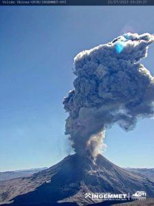
Ecuador , Sangay :
01 December 2021. Since 6:56 pm TL, the SAGA seismic station has recorded a tremor signal probably linked to the eruptive activity of Sangay. The signal amplitude of 1,200 events is low compared to the most active pulses of the current eruptive period of the volcano. Therefore, there is a low probability of ash fall in the areas surrounding the volcano. The IG-EPN continues to monitor the event and will notify in a timely manner if any changes in the seismic signals are detected.
December 02, 2021. Since 4:00 p.m. yesterday, the SAGA seismic station located to the southwest of the Sangay volcano has recorded a swarm of earthquakes of very similar shape and characteristics. The number of such earthquakes has increased steadily from 32 events per hour to 60 events per hour at the time of publication of this report.
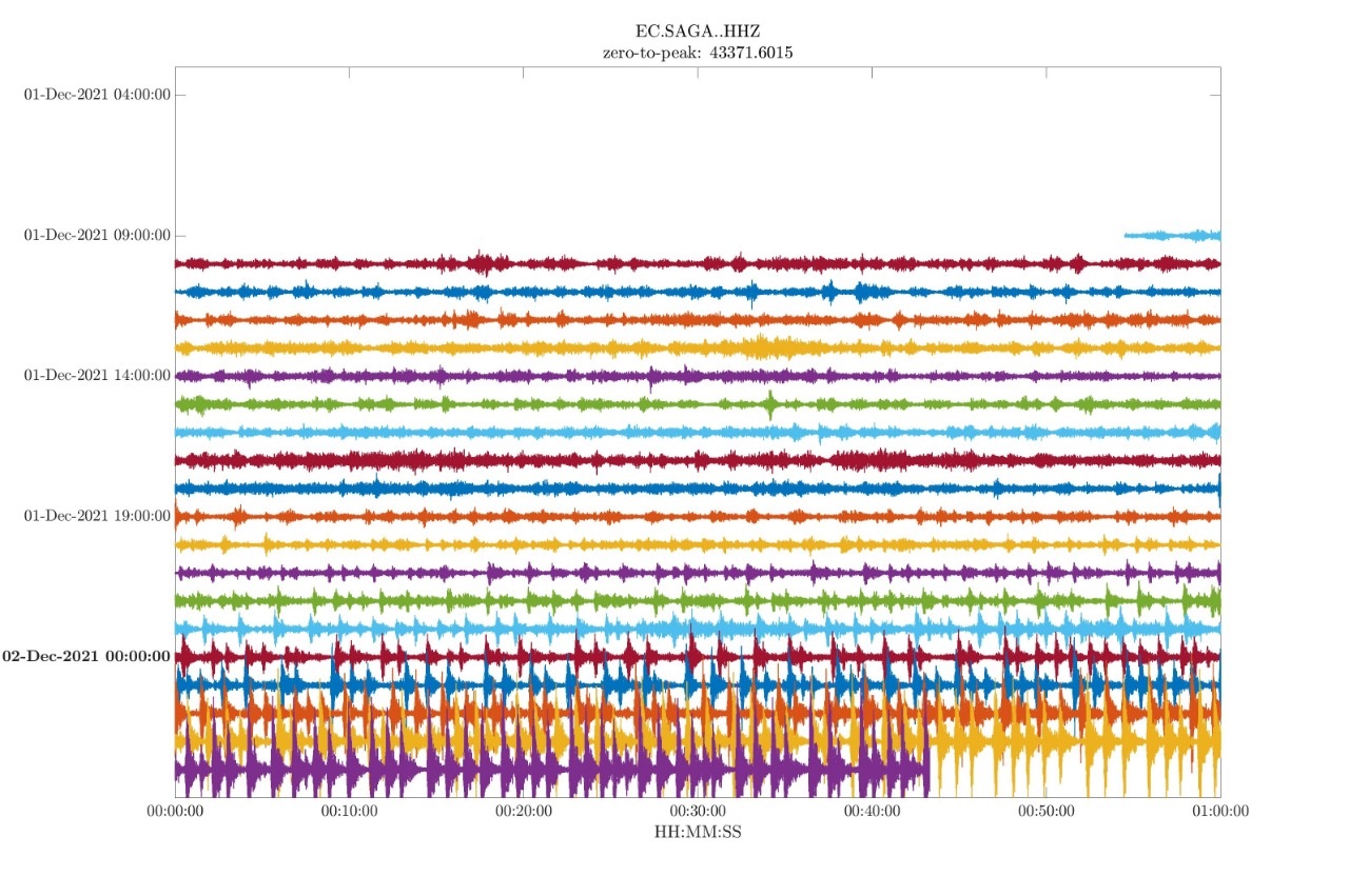
It has also been observed that these events are gaining in amplitude and in the last few hours they have already been large enough to be recorded at regional stations such as PUYO and BULB (Tungurahua). This type of activity is not frequent on the Sangay volcano, but it has been observed on other volcanoes such as Tungurahua. In these cases, these signals were preferentially associated with the presence of effusive phases during which the appearance and growth of a volcanic dome could occur. For the moment, no surface activity is observed on the satellite images.
Source : IGEPN.
Photo : TopMotor Storee.
La Réunion , Piton de la Fournaise :
Seismicity
In November 2021, the OVPF recorded in the Piton de la Fournaise massif a total of:
• 113 superficial volcano-tectonic earthquakes (0 to 2.5 km above sea level) below the summit craters;
• 12 deep earthquakes (below sea level);
• 250 collapses (in the Dolomieu Crater, the ramparts of the Enclos Fouqué and Piton de Crac , and the East River).
Volcano-tectonic activity under the Piton de la Fournaise in November 2021 was marked by a seismic crisis on November 17 between 6:12 p.m. (T.U., 10:12 p.m. local time) and 6:26 p.m. (UT, 10:26 p.m. local time), under the summit area. A total of 42 superficial volcano-tectonic earthquakes located under the northern edge of the Dolomieu crater were recorded during this crisis. No rapid deformation of the ground surface was recorded during this crisis, which means that the magma did not leave the shallow magmatic reservoir.
Following this seismic crisis, an increase in seismicity under the summit area was recorded from November 22, with an average of 6 earthquakes per day.
Deformation
The inflation (swelling) of the building, which began in April 2021, continued after the intrusion of October 18, 2021 and throughout November 2021.
This inflation showed a pressurization of the superficial magmatic reservoir located around 1.5-2 km deep.

Ground displacements (expressed in speed) recorded on the GPS stations inside and around the Enclos Fouqué in November 2021. The horizontal displacements are represented in vector form and the vertical displacements are indicated by the numerical values. in colour. The ellipse represents the measurement error (© OVPF-IPGP).
CO2 concentration in the soil
Following the eruption of December 2020, a continuous increase in CO2 emissions from the soil was recorded at the level of the distal sites (Plaine des Cafres sectors) but also proximal (Gîte du volcan ).
At remote sites, a trend reversal (decrease in CO2 emissions) occurred on February 12, 2021, witnessing a possible transfer of magma to more superficial crustal levels.
Source and graph : OVPF.
Read the full article : https://www.ipgp.fr/sites/default/files/ovpf_20211201_bullmensu.pdf
Photo : IPR