January 18 , 2020 .
Philippines , Taal :
ERUPTION UPDATE FOR TAAL VOLCANO ALERT LEVEL 4 (HAZARDOUS ERUPTION IMMINENT) 17 JANUARY 2020 05:00 PM
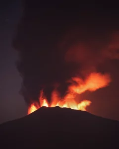
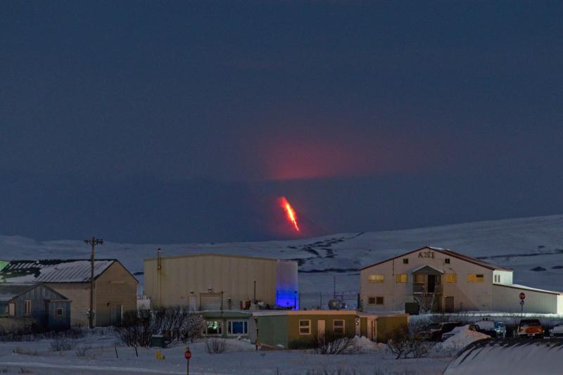
Since 8:00 AM this morning, Taal Volcano’s activity has been generally characterized by weak emission of steam-laden plumes 800 meters high from the Main Crater that drifted to the general southwest. A total of five (5) discrete weak explosions were recorded by the Taal Volcano Network.
The Philippine Seismic Network plotted a total of six hundred fifty-three (653) volcanic earthquakes since 1:00 PM, January 12, 2020. One hundred seventy-four (174) of these were felt with intensities ranging from Intensity I to V. Since 5:00 AM to 4:00 PM today, there were nineteen (19) volcanic earthquakes plotted. This signifies continuous magmatic intrusion beneath the Taal edifice, which may lead to further eruptive activity.
https://www.facebook.com/raffytima/videos/10157249117992758/
TAAL VOLCANO BULLETIN 18 January 2020 8:00 A.M.
Activity in the Main Crater in the past 24 hours has been characterized by steady steam emission and infrequent weak explosions that generated white to dirty white ash plumes 50 to 600 meters tall and dispersed ash southwest of the Main Crater.
Sulfur dioxide (SO2) emission was measured at an average of 360 tonnes/day yesterday, consistent with weak plume activity at the Main Crater.
https://www.facebook.com/mahar.lagmay/videos/10156879837938354/
The Philippine Seismic Network plotted a total of six hundred sixty-six (666) volcanic earthquakes since 1:00 PM, January 12, 2020. One hundred seventy-four (174) of these registered at magnitudes M1.2 – M4.1 and were felt at Intensities I – V. Since 5:00 AM on January 17, 2020 until 5:00 AM today, there were thirty-two (32) volcanic earthquakes plotted, registered at magnitudes M1.5 -M3.3. The Taal Volcano Network recorded eight hundred seventy-six (876) volcanic earthquakes including six (6) tremor events and twenty (20) low-frequency earthquakes. Such intense seismic activity likely signifies continuous magmatic intrusion beneath the Taal edifice, which may lead to further eruptive activity.
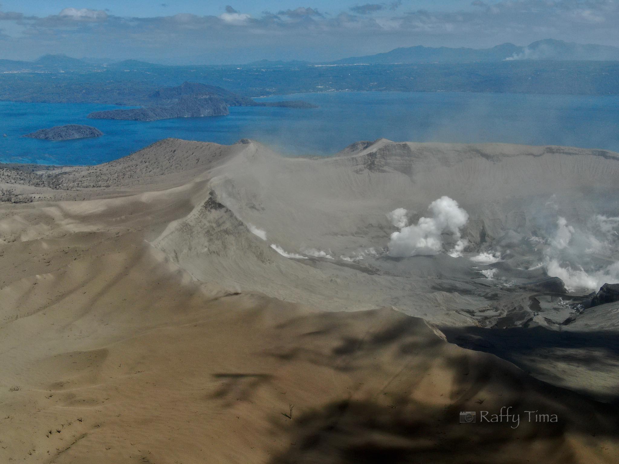
Alert Level 4 still remains in effect over Taal Volcano. This means that hazardous explosive eruption is possible within hours to days. DOST-PHIVOLCS strongly reiterates total evacuation of Taal Volcano Island and high-risk areas as identified in the hazard maps within the 14-km radius from Taal Main Crater and along the Pansipit River Valley where fissuring has been observed. Residents around Taal Volcano are advised to guard against the effects of heavy and prolonged ashfall. Civil aviation authorities must advise pilots to avoid the airspace around Taal Volcano as airborne ash and ballistic fragments from the eruption column pose hazards to aircraft.
DOST-PHIVOLCS is continually monitoring the eruption and will update all stakeholders of further developments.
Source : Phivolcs.
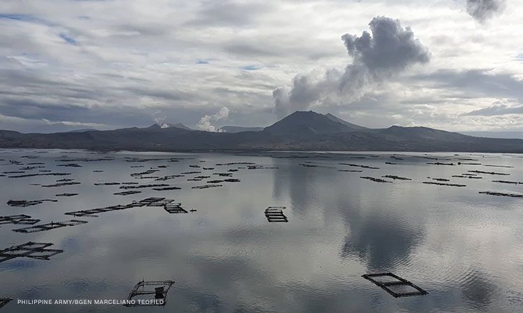
Photos : Raffy Tima , CNNPH / Marceliano Teofilo .
Videos : Raffy Tima , Mahar Lagmay .
Italy , Campi Flegrei :
Weekly bulletin from 07/01/2020 to 14/01/2020. (Updated January 14, 2020 at 12:00 p.m. local time).
SUMMARY OF ACTIVITY:
In light of the monitoring data:
1) Seismology: During the last week, in the Flegrei Campi, 9 earthquakes of small amplitude were recorded (Mdmax = 0.9).
2) Deformation: The average value of the uplift of approximately 0.7 cm / month since July 2017 in the zone of maximum deformation showed an increase between the end of November and the beginning of December, then returned to the usual average values after the swarm of the December 6. The uplift recorded at the RITE GPS station is approximately 59 cm since January 2011.
3) Geochemistry: The flow of CO2 from the ground measured last week did not show any significant change compared to the previous period, which confirms the persistence of the long-term trend. Last week, the temperature of the main fumarole of Pisciarelli showed an average value of around 114 ° C.
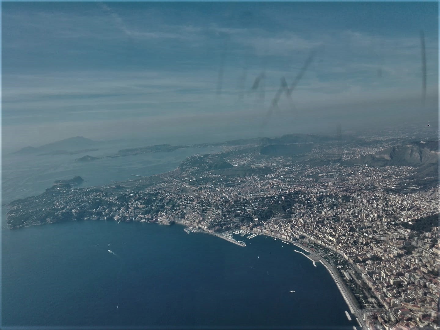
The photograph above shows the Phlegraean Fields taken from an airliner. In the distance the island of Ischia (photograph by Maddalena De Lucia).
Deformation:
The average value of the lifting speed in the maximum deformation zone of approximately 7 mm / month (8.5 cm / year ± 0.5 cm) recorded in July 2017, showed an increase in the weeks between the end of November and early December and then returned to the usual average values after the December 6 swarm. A time series analysis showed that the area was affected by a maximum lift of about 1 cm in the weeks between late November and early December. Further details are provided in the December 2019 Monthly Bulletin. The survey recorded at the RITE GPS station has been approximately 59 cm since January 2011, of which approximately 10 cm since January 2019.
Source : INGV.
Lire l’article : http://www.ov.ingv.it/ov/bollettini-campi-flegrei/Bollettino_Flegrei_2020_01_14.pdf
Photo : Maddalena De Lucia .
Alaska , Shishaldin :
54°45’19 » N 163°58’16 » W,
Summit Elevation 9373 ft (2857 m)
Current Volcano Alert Level: WATCH
Current Aviation Color Code: ORANGE
No notable eruptive activity occurred at Shishaldin Volcano over the past week, though a weak steam plume was occasionally visible in web camera views. The last significant eruptive activity occurred on Tuesday, January 7, when sustained explosive activity generated an ash plume that drifted over 200 km to the east-northeast, depositing trace ash fall on Cold Bay and King Cove and causing several flight cancellations. AVO raised the Aviation Color Code to RED and Alert Level to WARNING in response to that activity and lowering it back to ORANGE/WATCH that evening after the activity stopped. The volcano has remained relatively quiet since then and seismicity was low for most of the week. The level of seismicity has begun to climb over the past day, however, suggesting that the volcano could be building toward another episode of eruptive activity. Elevated surface temperatures were seen in satellite images over the past week, but also seemed slightly higher over the past day.
Thus far, the 2019 eruption has produced lava flows, pyroclastic flows, and lahars (mudflows). There has also been minor ash fallout on nearby communities, though ash emissions for most of the current eruption have been restricted to the flanks of the volcano and altitudes of less than 15,000 ft asl. As shown by the January 7 event, more powerful explosions could occur with little warning and produce higher ash clouds that may pose a hazard to aircraft.
Shishaldin is monitored by local seismic and infrasound sensors, satellite data, web cameras, a telemetered geodetic and tilt network, and distant infrasound and lightning networks.

Shishaldin volcano, located near the center of Unimak Island in the eastern Aleutian Islands, is a spectacular symmetric cone with a base diameter of approximately 16 km (10 mi). A 200-m-wide (660 ft) funnel-shaped summit crater typically emits a steam plume and occasional small amounts of ash. Shishaldin is one of the most active volcanoes in the Aleutian volcanic arc, with at least 54 episodes of unrest including over 24 confirmed eruptions since 1775. Most eruptions are relatively small, although the April-May 1999 event generated an ash column that reached 45,000 ft above sea level.
Source : AVO.
Photo : Merculief, Aaron , Loewen, Matt .
Mexico , Popocatepetl :
January 17, 10:00 a.m. (January 17, 4:00 p.m. GMT)
According to the monitoring systems of the Popocatepetl volcano, 155 exhalations and 296 minutes of tremors were identified, which were accompanied by emissions of volcanic gases and ash.
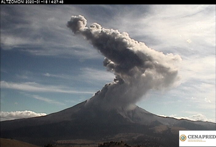
From this morning until the time of this report, we observed the continuous emission of volcanic gases and intermittent ash, which the wind disperses to the northwest.
CENAPRED urges NOT to APPROACH the volcano and especially the crater, because of the danger of falling ballistic fragments, and in case of heavy rain, to stay far from the bottom of the ravines because of the danger of mudslides and debris .
The Popocatépetl volcanic signaling light is in YELLOW PHASE 2.
Source : Cenapred .