September 02 , 2024.
Iceland : Reykjanes Peninsula :
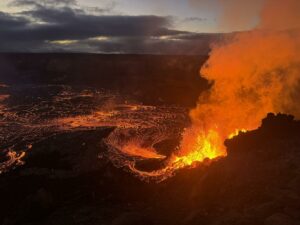
Samples of rapidly cooled lava were collected on the second and third days of the eruption, which began near Sundhnúksgígi on 22 August, and on the fourth day a sample of freshly fallen igneous rock was obtained. The samples were all collected from the area north of Stóra-Skógfell and the basaltic glass was chemically analysed at the Institute of Earth Sciences. Rockologically, the samples are very similar to previous samples from Sundhnúksgíga eruptions since December 2023 and contain vesicle-root glass with plagioclase, olivine and agite diols. The samples of rapidly cooled lava contain many microcrystals, but the igneous rock is crystalline.
The MgO concentration in the samples is between 5 and 7% or similar to previous eruptions at Sundhnúksgíga since December 2023. This suggests that magma of similar chemical composition has been accumulating in the magma reservoir beneath Svartsengi since late April. There is reason to believe that magma production and magma accumulation deep beneath the peninsula is moving towards a more stable state with less variation in composition, as was the case at Reykjaneseld in previous centuries.
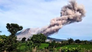
Eruption pollution hits Vogar
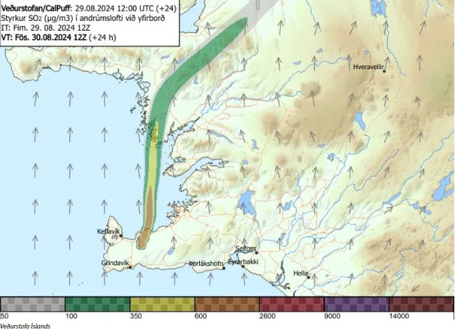
Pollution from the eruption at the Sundhnúks crater series is moving from the south across Vogar to Vatnsleysuströnd today. Residents should not engage in physical activity or strenuous outdoor work.
The wind is blowing dust and smoke from the volcanic eruption over Vatnsleysuströnd today. Some residents may experience eye and respiratory irritation.
Air quality is now poor in many parts of the southwest corner, due to pollution from the volcanic eruption at Sundhnúksgíga.
On the air quality meters of the Environmental Agency, the air quality is worst around the Vogur, where the levels of particulate matter are considered unhealthy.
People are also advised not to exercise or do hard work outdoors, and people with lung or heart disease should also avoid the outdoors.
« There was some pollution in the capital area this morning, and it’s still there, but it’s decreasing. The wind direction is changing to more of a southerly direction, so the plume is moving to the north. That means values are rising now in Vogar, and the forecast indicates that the pollution will lie over there more or less throughout the day », says Þorsteinn Jóhannsson, expert in air quality at the Environment Agency.
« These are such values that you can go from house to house and to school and work, but we do not recommend, for example, holding football practice or going out for a run in these conditions. And youngest children should be kept inside », says Þorsteinn.
Sources : Jardvis.hi.is/is , RUV .
Photos : Jakob Vegerfors ( 08/2024) , IMO.
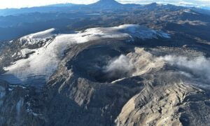
United-States , Yellowstone :
Sunday, September 1, 2024, 6:33 AM MDT (Sunday, September 1, 2024, 12:33 UTC)
44°25’48 » N 110°40’12 » W,
Summit Elevation 9203 ft (2805 m)
Current Volcano Alert Level: NORMAL
Current Aviation Color Code: GREEN
Summary
Since the hydrothermal explosion at Black Diamond Pool in Biscuit Basin on July 23, a number of minor water eruptions have occurred from the pool. Yellowstone Caldera activity remains at background levels, with about 40 located earthquakes in August (maximum = M2.0). Deformation measurements indicate a pause in subsidence (which has been ongoing since 2015) due to seasonal changes in snowmelt and groundwater conditions.
Recent Work and News
After the hydrothermal explosion at Black Diamond Pool in Biscuit Basin on July 23, several temporary sensors, including seismometers, temperature probes, and cameras, were established to monitor changes. Those data indicate the occurrence of several smaller events, possibly related to surges of water from the pool that moved rocks around the pool’s periphery and mostly occurring at night. No other thermal features in the region have shown significant changes, and Biscuit Basin remains closed to visitors.
Steamboat Geyser did not erupt during August, but frequent minor activity suggests that an eruption is likely in the coming days to weeks.
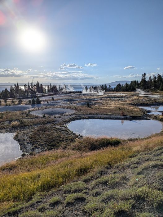
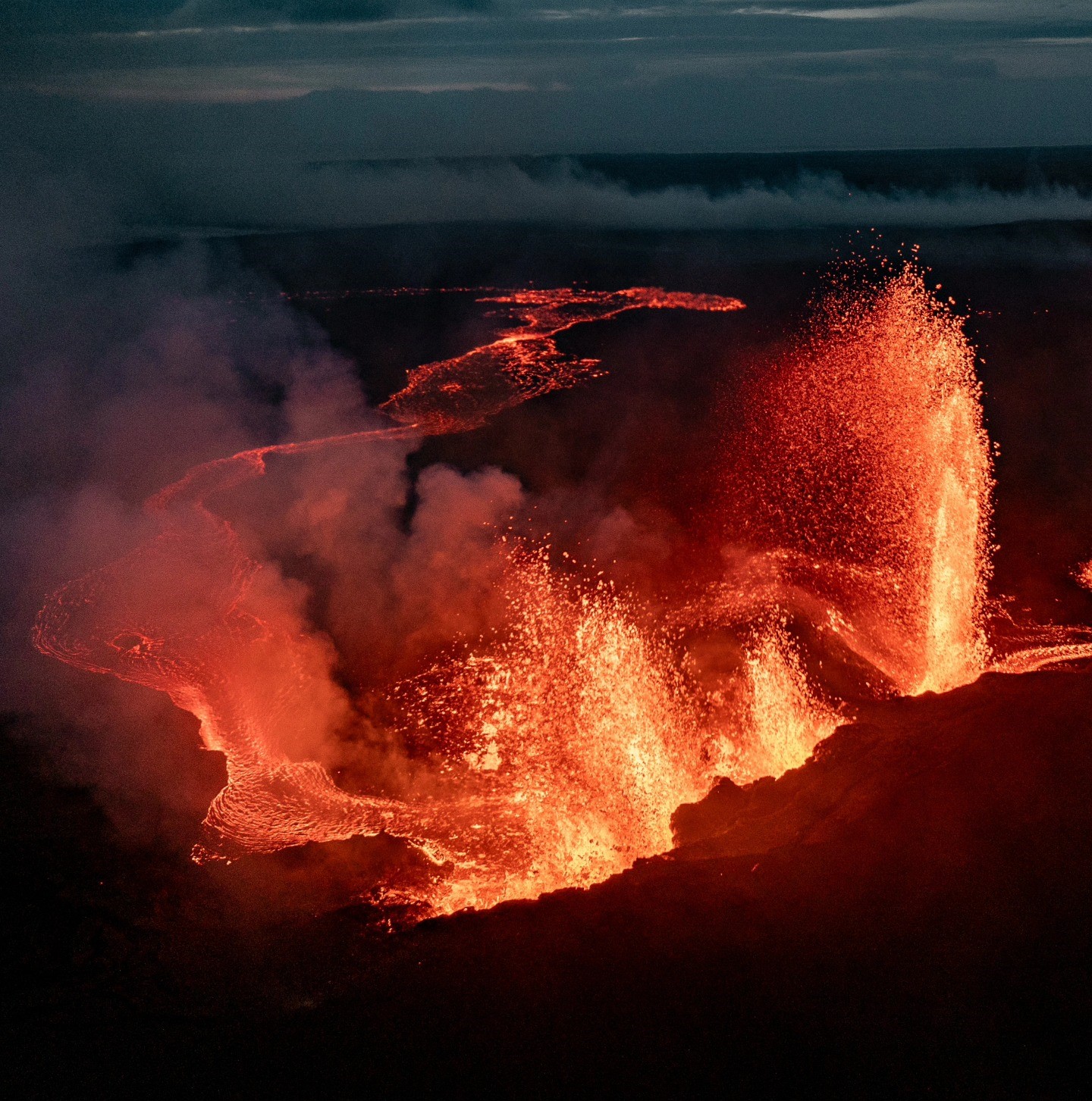
Sunrise over West Thumb Geyser Basin.
Yellowstone Volcano Observatory scientists were busy in August. Field work included geologic studies of glacial, hydrothermal, and volcanic deposits, maintenance of permanent seismic stations, deployment and maintenance of temporary seismic nodes and other geophysical equipment around Black Diamond Pool, recovery of 16 semipermanent GPS stations that were set up earlier in the spring/summer, and microgravity measurements throughout Yellowstone National Park. Additional work is planned in September, when geologists will conduct maintenance on the continuous gas sensor near Mud Volcano, collect water and gas samples from various sites around Yellowstone National Park, continue studies of glacial, hydrothermal, and volcanic processes, and perform additional maintenance on seismic and GPS stations.
Seismicity
During August 2024, the University of Utah Seismograph Stations, responsible for the operation and analysis of the Yellowstone Seismic Network, located about 40 earthquakes in the Yellowstone National Park region. The largest event of the month was a micro earthquake of magnitude 2.0 located about 22 miles south of Silver Gate, Montana, on August 11 at 3:12 PM MDT.
There were no swarms identified during the month of August.
Yellowstone earthquake activity is currently at background levels.
Ground Deformation
Since June, continuous GPS stations in Yellowstone Caldera and near Norris Geyser Basin have recorded a small amount (less than 1 cm, or a fraction of an inch) of uplift. This deformation occurs every summer and is caused by seasonal changes related to snowmelt and groundwater conditions throughout the region. Since 2015, Yellowstone Caldera has been subsiding at a rate of about 3 cm (1.2 in) per year, interrupted each summer by a seasonal summertime pause or slight uplift.
Source : YVO
Photo : Mike Poland, (28 août 2024.)
Ecuador , Reventador :
DAILY REPORT ON THE STATE OF THE REVENTADOR VOLCANO, Saturday, August 31, 2024.
Information Geophysical Institute – EPN.
Surface Activity Level: High, Surface Trend: No changes
Internal Activity Level: Moderate, Internal Trend: No changes
From August 30, 2024, 11:00 a.m. to August 31, 2024, 11:00 a.m.:
Seismicity:
Below is the count of seismic events recorded at the reference station
Explosion (EXP): 56
Precipitation / Lahars:
No rain has been recorded in the area of the volcano. **In the event of heavy rain, it could remobilize the accumulated materials and generate mud and debris flows that would descend the sides of the volcano and flow into the rivers downstream.**
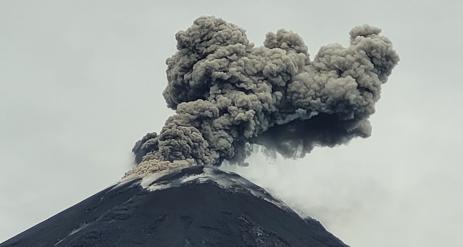
Emissions/ash column:
Due to transmission problems, it was not possible to observe the emissions through the surveillance camera system. On the other hand, thanks to the GOES-16 satellite system, an emission of gas and ash was recorded at a height of 800 meters above the crater level in a northwest direction. For its part, the VAAC agency in Washington published three emission reports with heights of 700 meters above the crater level in the north and northwest directions. In addition, reports from external observers indicate that this morning, an ash emission was observed at a height of less than 1,000 meters in a northwest direction.
Other monitoring parameters:
The FIRMS satellite system recorded 3 thermal anomalies, the MIROVA-MODIS system recorded 2 thermal anomalies and the MIROVA-VIIRS satellite system recorded 2 thermal anomalies, in the last 24 hours.
Observation:
Thanks to satellite monitoring, until the closing of this report, the volcanic sector remains partially clear.
Alert level: Orange
Source et Photo : IGEPN.
Kamchatka , Sheveluch :
VOLCANO OBSERVATORY NOTICE FOR AVIATION (VONA)
Issued: September 02 , 2024
Volcano: Sheveluch (CAVW #300270)
Current aviation colour code: ORANGE
Previous aviation colour code: orange
Source: KVERT
Notice Number: 2024-66
Volcano Location: N 56 deg 38 min E 161 deg 18 min
Area: Kamchatka, Russia
Summit Elevation: 3283 m (10768.24 ft), the dome elevation ~2500 m (8200 ft)
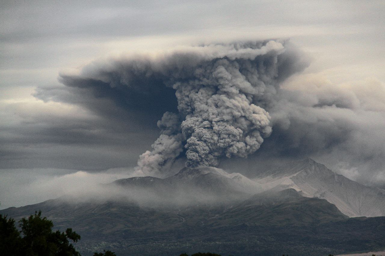
Volcanic Activity Summary:
Satellite data by KVERT showed an ash plume extending for 65 km to the north-east of the volcano.
An extrusive eruption of Sheveluch volcano continues. The danger of ash explosions up to 10 km (32,800 ft) a.s.l. remains. Ongoing activity could affect international and low-flying aircraft.
Volcanic cloud height:
3500-4000 m (11480-13120 ft) AMSL Time and method of ash plume/cloud height determination: 20240902/0140Z – Himawari-9 14m15
Other volcanic cloud information:
Distance of ash plume/cloud of the volcano: 65 km (40 mi)
Direction of drift of ash plume/cloud of the volcano: NE / azimuth 56 deg
Time and method of ash plume/cloud determination: 20240902/0140Z – Himawari-9 14m15
Source : Kvert
Photo : Viktor Frolov ( 18/08/2024)
Philippines , Mayon :
LAHAR ADVISORY FOR MAYON VOLCANO UNDER TROPICAL DEPRESSION “ENTENG”. 01 September 2024 , 11:40 PM
Based on the Tropical Cyclone Bulletin #4 issued at 8:00 PM today by the Philippine Atmospheric Geophysical and Astronomical Services Administration (PAGASA), Tropical Depression “ENTENG” is expected to maintain its strength and bring heavy to intense rains over Bicol Region and Eastern Visayas tonight until tomorrow evening (2 September). These rains could generate volcanic sediment flows or lahars, muddy streamflows or muddy run-off in rivers and drainage areas of Mayon Volcano.
.
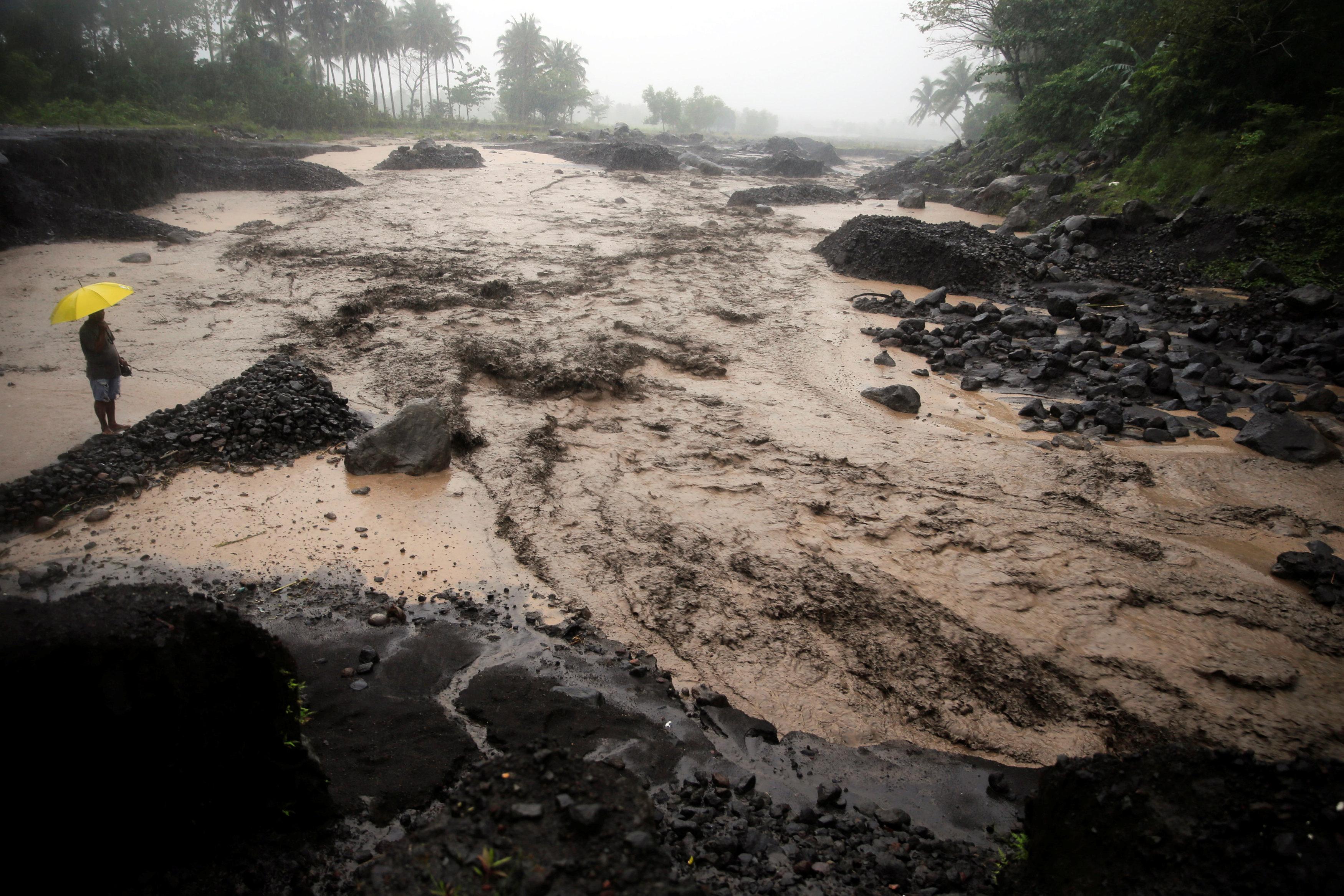
DOST-PHIVOLCS thus strongly recommends increased vigilance and readiness of communities in pre- determined zones of lahar and related hazards on this volcano. Prolonged and heavy rainfall may generate non-eruption lahars along river/stream channels draining the Mayon edifice. Potential lahars and sediment-laden streamflows may occur along the Miisi, Binaan, Anoling, Quirangay, Maninila, Masarawag, Muladbucad, Nasisi, Mabinit, Matan-ag, Bonga, Buyuan, Basud, and Bulawan Channels in Albay Province. Mayon lahars can threaten communities along the middle and lower slopes and downstream of these channels with inundation, burial and wash out.
DOST-PHIVOLCS strongly advises the communities and local government units of the above identified areas of risk to continually monitor the tropical depression conditions and take pre-emptive response measures for their safety from “ENTENG.”
Source : DOST-PHIVOLCS
Photo : Auteur inconnu