August 29 , 2024.
Alaska , Katmai :
AVO reports that wind is picking up ash from the 1912 Novarupta-Katmai eruption and carrying it to the southeast. The resuspension occurs during times of high winds and dry, snow-free conditions in the Katmai area.
Strong northwesterly winds in the vicinity of Katmai and the Valley of Ten Thousand Smokes have picked up loose volcanic ash erupted during the 1912 Novarupta-Katmai eruption and are carrying it to the southeast. The National Weather Service has issued a SIGMET for this low-level event and suggests that the maximum cloud height is 5,000 ft (1.5 km) above sea level.
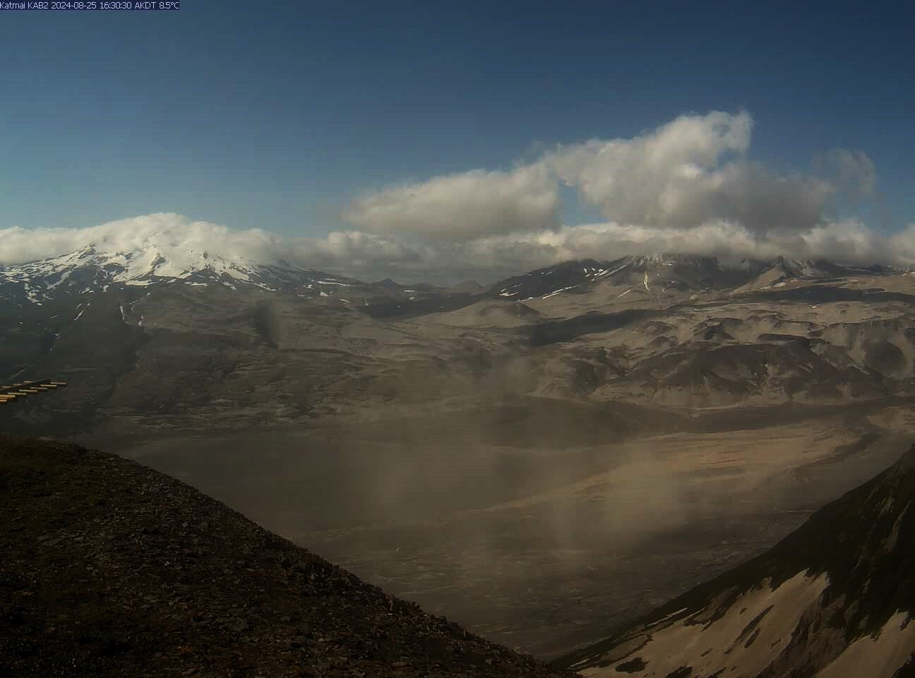
Image from AVO webcam KAB2 on August 25 at 4:30 pm AKDT shows the resuspended ash as puffs of brownish haze.
This phenomenon is not the result of recent volcanic activity and occurs during times of high winds and dry snow-free conditions in the Katmai area and other young volcanic areas of Alaska. No eruption is in progress. Trident Volcano remains at color code YELLOW due to elevated earthquake activity, while other volcanoes of the Katmai area (Snowy, Griggs, Katmai, Novarupta, Mageik, Martin) remain at color code GREEN. Resuspended volcanic ash should be considered hazardous and could be damaging to aircraft and health.
Source et photo : AVO
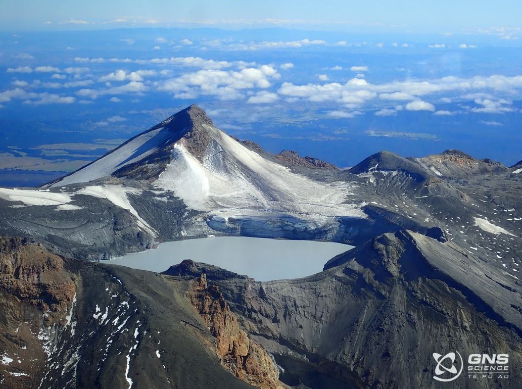
New Zealand , Ruapehu :
Minor volcanic unrest continues at Mt Ruapehu as lake cools. Volcanic Alert Level remains at 1.
Published: Thu Aug 29 2024 10:00 AM
Over the last six months at Ruapehu, Te Wai ā-moe (Crater Lake) has slowly cooled from 31 °C to 11 °C. Our volcanic gas monitoring continues to measure low-moderate volcanic gas emissions. The Volcanic Alert Level remains at 1 and the Aviation Colour Code at Green.
Te Wai ā-moe (Crater Lake) temperature continues to slowly decline. Currently the lake temperature is around 11 ºC, down from a peak of 31 ºC on 14 February. The current temperature is one of the coldest recorded in the lake since we started measurements in the 1950s (Figure 1). The amount of sulphur dioxide (SO2) volcanic gas passing through the lake has also declined with the lake temperature. The daily average gas flux from our scanDOAS (Differential Optical Absorption Spectrometry) sensors has fallen from approximately 2 kg/s (172 tonnes per day) in February to about 1 kg/s (86 tonnes per day) this week. The lake water level has been variable, due to rain and/or snow, but is usually around overflow.
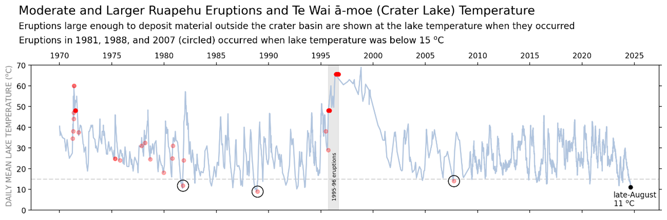
Fig. 1. Temperature of Te Wai ā-moe with moderate-to-large eruptions shown by red dots. When many eruptions occurred close together the dots overlap and appear more intense (black circles highlight eruptions when the lake temperature was below 15 ºC).
The rate of heat input into the lake has also fallen from around 200-250 MW in February to around 50 MW’s now. The cooling of Te Wai ā-moe, together with declining gas flux, is consistent with cooling of the hydrothermal system beneath the lake.
The unusual volcanic earthquakes initially identified in March continued through to June. The occurrence of these uncommon style of small volcanic earthquakes beneath Ruapehu has now ceased. Volcanic tremor levels, generated by fluid and gas flow in the hydrothermal system, have remained low all year.
The temperature of Te Wai ā-moe fluctuates due to semi-regular heating cycles (Figure 1). Research on the eruptive history of Ruapehu has shown that the probability of an eruption increases when the lake is significantly warmer or colder than the median temperature. However, eruptions have been significantly more frequent when the lake was hot rather than cold. Since 1970, 115 eruptions large enough to impact the summit area have occurred, with only three taking place when the lake is cooler than 15 ºC (Figure 1).
Our recent observations are consistent with ongoing, low-level volcanic unrest at Ruapehu. Low lake temperatures and limited gas emissions indicate that the hydrothermal system is partially sealed, restricting heat and gas flow to the surface. We expect a new heating cycle to begin over the coming weeks based on past temperature trends.
Because the hydrothermal system is partially sealed, any new gas and heat flow strong enough to rupture the seal may lead to a small eruption. This has occurred on three previous occasions (1981, 1988, 2007; Fig. 1). However, in the majority of cases, a new heating cycle begins without an eruption. Thus, a sudden eruption at Mt Ruapehu remains very unlikely.
Monitoring indicators remain consistent with a low level of volcanic activity. As a result, the Volcanic Alert Level remains at 1. The Aviation Colour Code remains Green.
Source : Geonet / Paul Jarvis / Duty Volcanologist.
Photos : Geonet , GNS Science ( 2022)
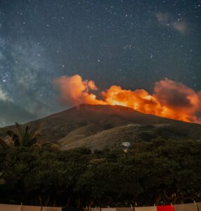
Colombia , Nevado del Ruiz :
Manizales, August 27, 2024, 7:20 p.m.
From the monitoring of the activity of the Nevado del Ruiz volcano, the Colombian Geological Survey (SGC), an entity attached to the Ministry of Mines and Energy, reports that:
During the week of August 20 to 26, 2024, the volcano continued with unstable behavior. The main variations in the monitored parameters, compared to the previous week, were:
– Seismicity related to the activity of fluids inside volcanic conduits increased in the number of earthquakes recorded and in the seismic energy released. The seismic signals presented variable energy levels with values ranging from low to moderate.
During the week, the increase in long-period signals was notable. Thanks to the cameras used to monitor the volcano, it was possible to confirm several ash emissions and changes in the temperature of the emitted material, both phenomena being associated with some of these seismic events.

– Seismic activity associated with the fracturing of rocks inside the volcanic edifice decreased in the number of recorded earthquakes and increased in the seismic energy released.
The earthquakes were located mainly in the Southeast and East-Northeast sectors of the volcano, at distances less than 3 km from the crater, and in the Arenas crater. To a lesser extent and in a scattered manner, some earthquakes were also located in the North-Northwest, West, Southwest, Northeast and Southeast sectors, at distances of up to 11 km from the crater. The depths of the events varied between less than 1 km and 7 km from the summit of the volcano. The highest magnitude of the week was 1.5, corresponding to the earthquake recorded on August 21 at 01:59, located 2 km southeast of the crater, at a depth of 4 km.
– The emission of water vapor and gas into the atmosphere from the Arenas crater continues. Sulfur dioxide (SO₂) degassing rates were similar to those reported the previous week. The maximum height of the gas column was 900 m vertically and 1,300 m in dispersion. These values were measured at the summit of the volcano on August 24, during the ash emission recorded at 18:17 . The direction of dispersion of the gas column was variable with a preferential trend towards the West-Northwest of the volcano.
– When monitoring thermal anomalies at the bottom of the Arenas crater, from satellite monitoring platforms, their detection continues to be limited by the atmospheric conditions prevailing in the area. However, during the week, low energy level anomalies were detected.
Source : SGC
Photo : SGC ( archive 2023)
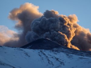
Japan , Sakurajima :
JMA reported ongoing eruptive activity at Minamidake Crater (Aira Caldera’s Sakurajima volcano) during 19-26 August. Nighttime crater incandescence was visible in webcam images. Eruptive events at 09h01 and 09h26 on 21 August produced ash plumes that rose 1-1.4 km above the crater rim and drifted N. An explosion at 14h57 on 21 August generated an ash plume that rose as high as 2.7 km and drifted N and ejected large blocks 800-1,200 m from the crater rim. Sulfur dioxide emissions were somewhat high that day, averaging 1,800 tons per day. The Alert Level remained at 3 (on a 5-level scale), and the public was warned to stay 1 km away from both craters.
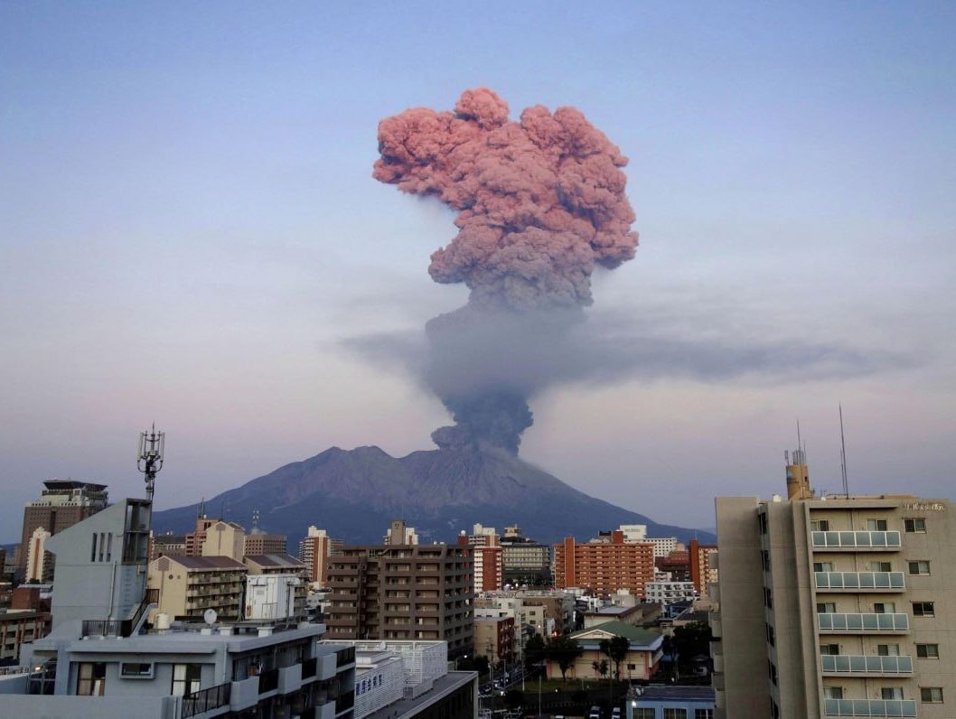
The Aira caldera in the northern half of Kagoshima Bay contains the post-caldera Sakurajima volcano, one of Japan’s most active. Eruption of the voluminous Ito pyroclastic flow accompanied formation of the 17 x 23 km caldera about 22,000 years ago. The smaller Wakamiko caldera was formed during the early Holocene in the NE corner of the caldera, along with several post-caldera cones. The construction of Sakurajima began about 13,000 years ago on the southern rim and built an island that was joined to the Osumi Peninsula during the major explosive and effusive eruption of 1914. Activity at the Kitadake summit cone ended about 4,850 years ago, after which eruptions took place at Minamidake. Frequent eruptions since the 8th century have deposited ash on the city of Kagoshima, located across Kagoshima Bay only 8 km from the summit. The largest recorded eruption took place during 1471-76.
Sources : Agence météorologique japonaise (JMA) , GVP.
Photo : Deniss García Mendoza ( 03 /2023).
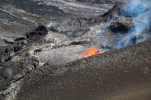
Hawaii , Kilauea :
Wednesday, August 28, 2024, 9:05 AM HST (Wednesday, August 28, 2024, 19:05 UTC)
19°25’16 » N 155°17’13 » W,
Summit Elevation 4091 ft (1247 m)
Current Volcano Alert Level: ADVISORY
Current Aviation Color Code: YELLOW
Activity Summary:
Kīlauea is not erupting. Earthquake activity remains elevated in Kīlauea’s upper East Rift Zone (UERZ), but has decreased over the past day. Changes in the character and location of unrest can occur quickly, as can the potential for eruption, but there are no signs of imminent eruption at this time. There are no significant changes in activity in the lower East Rift Zone and Southwest Rift Zone.
Summit Observations:
Approximately 24 earthquakes were detected beneath Kaluapele (Kīlauea’s summit caldera) over the past 24 hours at depths of 1–3 km (0.6–1.9 mi) below the ground surface, most with magnitudes of less than M2.0. Rates of deformation at the summit remained relatively low, with inflationary tilt at summit tiltmeters over the past day. An overall gradual inflationary trend continues to be seen on GPS instruments around the summit region. The most recent measurement of the summit’s SO2 emission rate was approximately 75 tonnes per day on August 20, 2024.
Rift Zone Observations:
Over the past 24 hours, there have been approximately 28 earthquakes beneath Kīlauea’s UERZ region, extending from Puhimau Crater southeast to Maunaulu. Most earthquakes have been smaller than M2.0. Events have remained at depths of 1–3 km (0.6–1.8 miles) beneath the surface. Currently, deformation remains stable and level over the past 24 hours.
Activity in the middle East Rift Zone (MERZ) remains low. There were no significant changes in the POC tiltmeter over the past day. GPS instruments continue to record inflation in the region.
Measurements from continuous gas monitoring stations downwind of Puʻuʻōʻō in the middle East Rift Zone—the site of 1983–2018 eruptive activity—remain below detection limits for SO2, indicating that SO2 emissions from this area are negligible.
At this time, there is no evidence of elevated seismicity or ground deformation beneath the lower East Rift Zone, and Southwest Rift Zone activity remains low. Current activity is restricted to the summit and upper East Rift Zone region.
Source : HVO
Photo : USGS / M. Patrick.