February 18 2022.
Archipelago of Vanuatu , Ambae :
Last update on the activity of the Ambae volcano, February 18, 2022 at 2:08 p.m.:
The activity of the Ambae volcano continues at a state of major unrest, compatible with Volcanic Alert Level 2. The Ambae volcano continues to emit plumes of steam, gas and volcanic ash. New observations and analyzes suggest that the cone of the volcano inside Lake Voui continues to accumulate and that stronger explosions could propel ash emissions higher. With this current volcanic activity, it is worth remembering that eruptions can occur at any level of unrest with little or no warning.
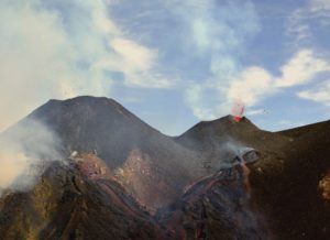
Eruption column above the Manaro crater in Lake Voui, Ambae volcano, February 16.
Areas and villages near the volcano, especially those exposed to wind directions, can continue to expect volcanic gas and/or ash impacts.
The danger zone (danger zone A) remains 2 km around the volcanic vents and inside the area of the overflowing streams. Additionally, the remaining volcanic ash at the top and around the island (deposited during the 2017/2018 eruption) can be remobilized by precipitation. Villages near streams (dangerous flow areas) can expect changes in stream behavior and higher than normal flows during heavy rainfall events (CURRENTLY IN THIS SEASON)
Residents of Ambae Island should be aware of dangerous water flows when approaching these streams during heavy rains.
The Department of Meteorology and Geohazards will continue to monitor this volcanic activity closely. More information will be provided if needed.
Source : Geohazard.
Photo : Nixon Tambean
Philippines , Taal :
TAAL VOLCANO BULLETIN 18 February 2022 8:00 AM
In the past 24-hour period, the Taal Volcano Network recorded seventeen (17) volcanic earthquakes, including thirteen (13) volcanic tremor events having durations of one (1) to two (2) minutes, three (3) low-frequency volcanic earthquakes, and one (1) high-frequency volcanic earthquake. Activity at the Main Crater was dominated by upwelling of hot volcanic fluids in its lake which generated plumes 1500 meters tall that drifted southwest. Sulfur dioxide (SO2) emission averaged 2,456 tonnes/day on 16 February 2022. Based on ground deformation parameters from electronic tilt, continuous GPS and InSAR monitoring, Taal Volcano Island and the Taal region has begun deflating in October 2021.
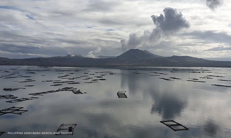
Alert Level 2 (Increased Unrest) prevails over Taal Volcano. DOST-PHIVOLCS reminds the public that at Alert Level 2, sudden steam- or gas-driven explosions, volcanic earthquakes, minor ashfall, and lethal accumulations or expulsions of volcanic gas can occur and threaten areas within and around TVI. DOST-PHIVOLCS strongly recommends that entry into Taal Volcano Island, Taal’s Permanent Danger Zone or PDZ must be strictly prohibited, especially the vicinities of the Main Crater and the Daang Kastila fissure, and extended stays on Taal Lake.
Source : Phivolcs.
Photo : CNNPH , marcello Teofilo .
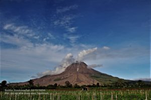
Indonesia , Ibu :
VOLCANO OBSERVATORY NOTICE FOR AVIATION – VONA
Issued : February 18 , 2022.
Volcano : Ibu (268030)
Current Aviation Colour Code : ORANGE
Previous Aviation Colour Code : orange
Source : Ibu Volcano Observatory
Notice Number : 2022IBU06
Volcano Location : N 01 deg 29 min 17 sec E 127 deg 37 min 48 sec
Area : North Maluku, Indonesia
Summit Elevation : 4240 FT (1325 M)
Volcanic Activity Summary :
Eruption with volcanic ash cloud at 00h56 UTC (09h56 local).
Volcanic Cloud Height :
Best estimate of ash-cloud top is around 6800 FT (2125 M) above sea level, may be higher than what can be observed clearly. Source of height data: ground observer.
Other Volcanic Cloud Information :
Ash-cloud moving to southwest.
Remarks :
Eruption and ash emission is continuing.
The volcano was clearly visible until it was covered by fog. Smoke from the crater is white / gray with moderate to high intensity, about 200-800 meters above the summit. The weather is sunny to rainy, the wind is light to strong in the East and North-West. An eruption occurred at a height of 200-800 meters above the summit, the eruption ash column was white / gray. There was an avalanche, but visually the distance and direction of the slide was not observed.
Seismicity linked to eruptions, avalanches, smoke emissions from the crater and magma activity. It was recorded:
– 68 earthquakes of eruptions/explosions
– 32 avalanche earthquakes
– 23 emission earthquakes
– 25 shallow volcanic earthquakes
Sources : Magma Indonésie , PVMBG.
Photo : Martin Rietze .
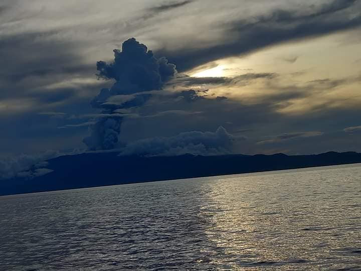
Democratic Republic of Congo , Nyiragongo :
A small lava lake finally formed inside the crater of the Nyiragongo volcano, around 9 months after the last eruption on May 22, 2021.
This information is reported by MONUSCO experts after an overflight on Tuesday, February 15.
In addition, the OVG says it notes a drop in seismicity in the volcano area.
In a recent periodic bulletin, the Volcanological Observatory of Goma (OVG) specifies that following monitoring from February 7 to 14, the finding is that about 5 low-intensity earthquakes are recorded each day in the Nyiragongo area compared to previous weeks.
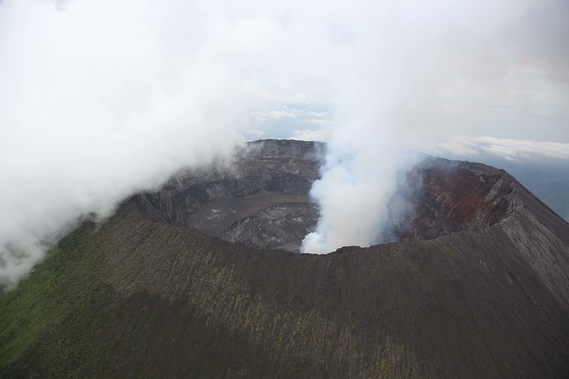
For his part, the MONUSCO volcanologist expert, Dario Tedesco, after an observation flight above Mount Nyiragongo, indicates that, « for the first time since its eruption in May 2021, the formation of a small lava lake inside the crater ».
In his report, Dario Tedesco specifies that the current state of the Nyiragongo volcano is normalizing as after the 2002 eruption.
Small collapses of the old internal terraces are, according to him, at the origin of the dust or volcanic ash which is released into the atmosphere. He calls on the inhabitants, in particular of Goma, to follow the hygiene procedures enacted.
In addition, on February 13 and 14, the OVG reported, other earthquakes in the region, of magnitude 2.2; 4.7 and 4.9. These tremors were felt by the inhabitants of Goma, for the first, those of Uvira, Bujumbura, Watalinga and Uganda, for the others.
Source : Radiookapi.net
Photo : MONUSCO / Abel Kavanagh
Hawaii , Kilauea :
19°25’16 » N 155°17’13 » W,
Summit Elevation 4091 ft (1247 m)
Current Volcano Alert Level: WATCH
Current Aviation Color Code: ORANGE
Activity Summary:
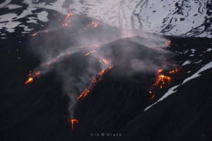
The summit eruption of Kīlauea Volcano resumed approximately 2:30 am HST within the western part of Halemaʻumaʻu. All recent lava activity has been confined to the crater, and there are no indications of activity migrating elsewhere on Kīlauea.
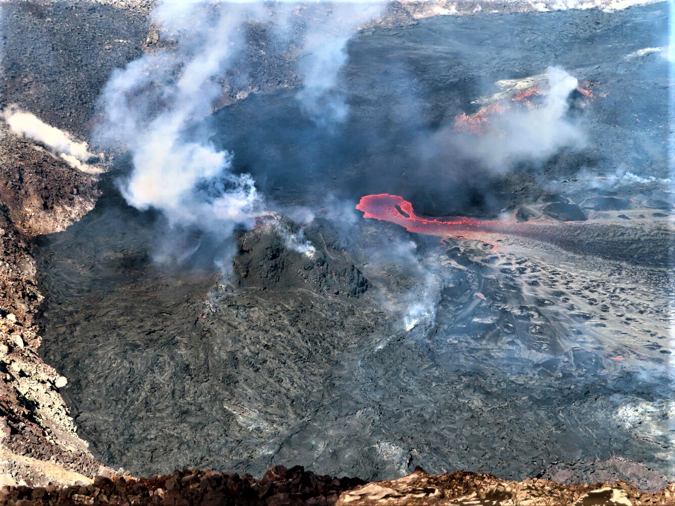
Halemaʻumaʻu Lava Lake Observations:
Effusion of lava resumed at approximately 2:30 am HST and continues this morning. This has resulted in an increase in the lava surface level to pre-pause levels with minor short overflows of the active western lava lake. This resumption corresponds with an inflationary signal that started at approximately 5:00 pm HST on February 16. The active lava lake is now approximately 89 meters (292 feet) deep relative to when lava emerged on September 29, 2021. Measurements on January 25, 2022, indicated that the total lava volume effused since the beginning of the eruption was approximately 45 million cubic meters (12.0 billion gallons) at that time.
Summit Observations:
Summit tiltmeters indicated that Kīlauea summit was entering a period of increased inflation beginning approximately 5:00 pm HST on February 16. This reached its maximum tilt at approximately 3:00 am (February 17) with about 2.9 microradians of change and has since started a very slow deflationary trend. Seismic data shows that the volcanic tremor signal started to increase around the time that the eruption resumed activity at approximately 2:20 to 2:30 am HAST this morning. Earthquake activity at the summit remains below background level. A sulfur dioxide (SO2) emission rate of approximately ~2800 tonnes per day (t/d) was measured yesterday, February 14.
Source : HVO
Photo : USGS / J.M. Chang.