June 26 , 2024.
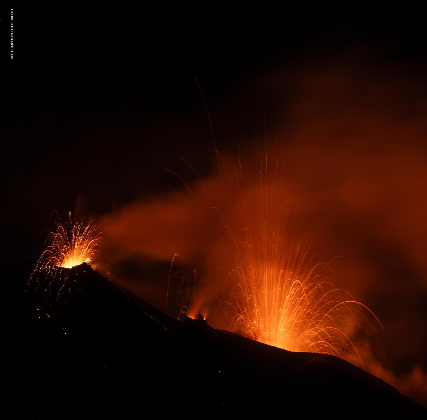
Italy , Stromboli :
WEEKLY BULLETIN, from June 17, 2024 to June 23, 2024. (issue date June 25, 2024)
SUMMARY STATEMENT OF ACTIVITY
In light of the monitoring data, it appears:
1) VOLCANOLOGICAL OBSERVATIONS: During this period, normal Strombolian activity was observed with splashing activity and lava overflow from the North N1 zone. The total hourly frequency varied between medium (14 events/h) and high values (20 events/h). The intensity of the explosions was mainly low and medium in the North and South Central crater areas.
2) SISMOLOGY: The seismological parameters monitored do not show significant variations, with the exception of the increase in the amplitude of the earthquake from 06/19. We also note the occurrence of two earthquakes of local magnitude greater than or equal to 1.0 on 06/21.
3) GROUND DEFORMATIONS: Continuous signals from ground deformation monitoring networks did not show significant variations
4) GEOCHEMISTRY: The SO2 flow is at an average level
The CO2 flux in the summit zone is at average values.
The C/S ratio in the plume is at average values.
There are no updates to the helium isotope ratio in the thermal aquifer.
CO2 flow in Mofeta in the San Bartolo area: stable at high values.
CO2 flux in Scari: stable values at medium-high levels.
5) SATELLITE OBSERVATIONS: Thermal activity observed by satellite was generally at a moderate level.
VOLCANOLOGICAL OBSERVATIONS
In the observed period, the eruptive activity of Stromboli was characterized through the analysis of images recorded by the INGV-OE surveillance cameras located at Pizzo (SPT), at altitude 190 m (SCT-SCV) and at Point dei Corvi (SPCT). . The explosive activity was mainly produced by three eruptive vents located in the northern area of the crater and by two vents located in the central southern area.
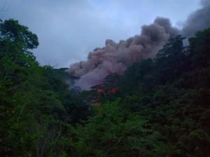
A lava overflow was observed on June 23, 2024 from the northern area of the crater
Observations of explosive activity captured by surveillance cameras
In the area of the North crater (N), with two vents located in sector N1 and one in sector N2, explosive activity was observed mainly of low intensity (less than 80 m height) to medium (less than 150 m height). ). Furthermore, projection activity was observed, sometimes intense in sector N1, this activity being the origin of the lava overflow of June 23. The products emitted in the eruption were mainly coarse materials (bombs and lapilli). The average frequency of explosions varied between 6 and 14 events/h.
In the South-Central (CS) zone, sectors C and S1 showed no activity, while in sector S2 the explosions varied in intensity from low (less than 80 m in height) to high (more than 150 m height) emitting fine materials mixed with coarse materials. The average frequency of explosions varied between 5 and 8 events/h.
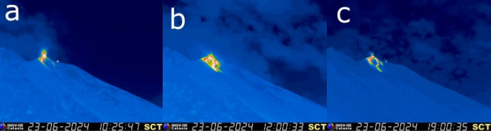
Lava overflow of June 23, 2024
On June 23 from 10:25 UTC, after intense projection activity from sector N1, a lava overflow began. Multiple flows propagated from N1 then converged in the incision dug by the pyroclastic flow of October 9, 2022, and were placed along the Sciara del Fuoco. After a few hours, the energy of the event decreased and the overflow cooled around 19 UTC.
In a press release published today, Civil Protection determined the move to orange alert for the Stromboli volcano.
This decision was adopted in light of the evaluations that emerged during the meeting with the Competence Centers and the Department of Civil Protection of the Sicilian Region.
Source : INGV
Photos : Stromboli stati d’animo / Sebastiano Cannavo , INGV.
Kamchatka , Karymsky :
VOLCANO OBSERVATORY NOTICE FOR AVIATION (VONA)
Issued: June 26 , 2024.
Volcano: Karymsky (CAVW #300130)
Current aviation colour code: ORANGE
Previous aviation colour code: orange
Source: KVERT
Notice Number: 2024-31
Volcano Location: N 54 deg 2 min E 159 deg 26 min
Area: Kamchatka, Russia
Summit Elevation: 1486 m (4874.08 ft)
Volcanic Activity Summary:
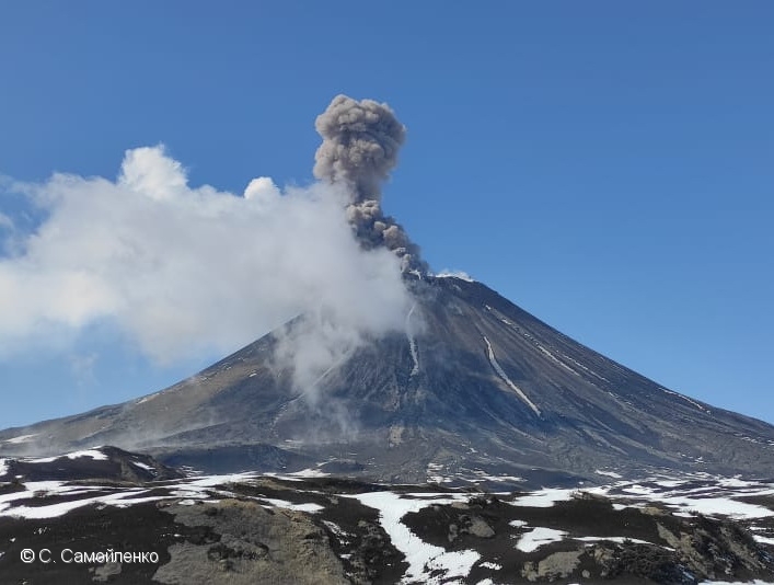
The explosive activity of the Karymsky volcano continues. Satellite data by KVERT showed explosions sent ash 4.5-5 km a.s.l. from the volcano, and an ash cloud 15×20 km in size is drifting for 23 km to the west-northwest of the volcano.
A moderate explosive activity of the volcano continues. Ash explosions up to 10 km (32,800 ft) a.s.l. could occur at any time. Ongoing activity could affect international and low-flying aircraft.
Volcanic cloud height:
4500-5000 m (14760-16400 ft) AMSL Time and method of ash plume/cloud height determination: 20240626/0230Z – Himawari-9 14m15
Other volcanic cloud information:
Distance of ash plume/cloud of the volcano: 23 km (14 mi)
Direction of drift of ash plume/cloud of the volcano: WNW / azimuth 288 deg
Time and method of ash plume/cloud determination: 20240626/0230Z – Himawari-9 14m15
Start time of explosion and how determined: 20240626/0030Z – Satellite data
Source : Kvert
Photo : S. Samoylenko ( Archive).
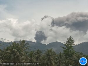
Indonesia , Lewotobi Laki-laki :
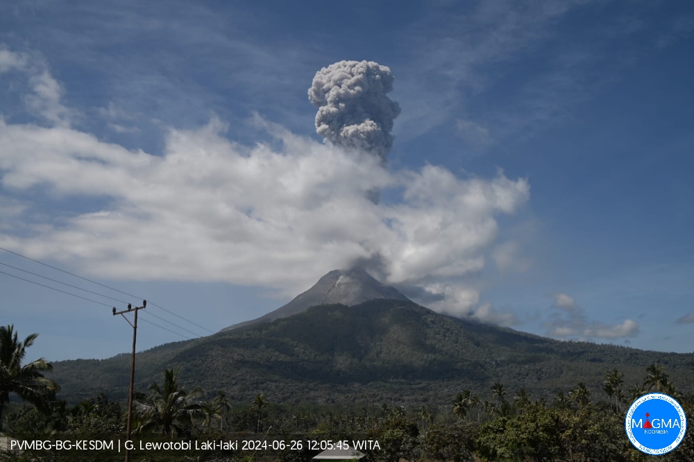
An eruption of Mount Lewotobi Laki Laki occurred on Wednesday June 26, 2024 at 11:45 WITA with the height of the ash column observed at ±1000 m above the summit (±2584 m above sea level) . The ash column was observed to be gray with thick intensity, oriented to the West and Northwest. This eruption was recorded on a seismograph with a maximum amplitude of 47.3 mm and a duration of 732 seconds.
VOLCANO OBSERVATORY NOTICE FOR AVIATION – VONA
Issued : June 26 , 2024
Volcano : Lewotobi Laki-laki (264180)
Current Aviation Colour Code : ORANGE
Previous Aviation Colour Code : orange
Source : Lewotobi Laki-laki Volcano Observatory
Notice Number : 2024LWK120
Volcano Location : S 08 deg 32 min 20 sec E 122 deg 46 min 06 sec
Area : East Nusa Tenggara, Indonesia
Summit Elevation : 5069 FT (1584 M)
Volcanic Activity Summary :
Eruption with volcanic ash cloud at 03h45 UTC (11h45 local).
Volcanic Cloud Height :
Best estimate of ash-cloud top is around 8269 FT (2584 M) above sea level or 3200 FT (1000 M) above summit. May be higher than what can be observed clearly. Source of height data: ground observer.
Other Volcanic Cloud Information :
Ash cloud moving from west to northwest. Volcanic ash is observed to be gray. The intensity of volcanic ash is observed to be thick.
Remarks :
Eruption recorded on seismogram with maximum amplitude 47.3 mm and maximum duration 732 second.
Source et photo : Magma Indonésie.
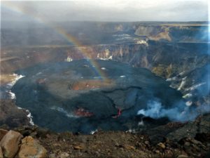
Chile , Villarica :
Special Report on Volcanic Activity (REAV), Auracania region, Villarica volcano, June 25, 2024, 07:00 local time (mainland Chile).
The National Service of Geology and Mines of Chile (Sernageomin) publishes the following PRELIMINARY information, obtained using the monitoring equipment of the National Volcanic Monitoring Network (RNVV), processed and analyzed at the Southern Andean Volcanological Observatory ( Ovdas):
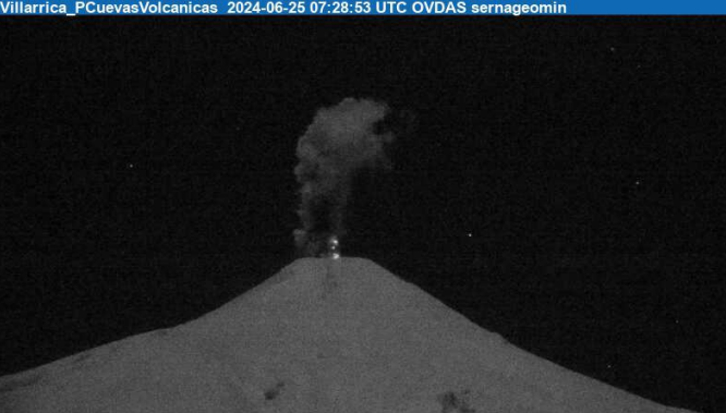
On Tuesday June 25, 2024, at 04:28 local time (07:28 UTC), monitoring stations installed near the Villarica volcano recorded an explosion with the expulsion of incandescent particulate materials and a column of gas, with a maximum height of 700 m above from the level of the crater, and a preferential dispersion direction in the West direction.
OBSERVATIONS:
This event had low seismic efficiency. No noticeable seismicity was recorded, only a background tremor. Monitoring parameters remain stable.
The technical volcanic alert remains at the Yellow level.
Source et photo : Sernageomin.
Colombie , Chiles / Cerro Negro :
San Juan de Pasto, June 25, 2024, 5:50 p.m.
Weekly Activity Bulletin: Chiles Volcanic Complex and Cerro Negro (CVCCN)
Regarding the monitoring of the activity of the CHILES AND CERRO NEGRO VOLCANOES, the COLOMBIAN GEOLOGICAL SERVICE (SGC), an entity attached to the MINISTRY OF MINES AND ENERGY, reports that:
During the week evaluated, between June 18 and 24, 2024 and compared to previous weeks, a considerable increase was recorded both in the frequency of earthquakes and in the energy released. The predominance of seismicity associated with rock fracture within the volcanic system and the recording of seismicity linked to fluid dynamics within the volcanic system are maintained. Some of them have very low dominant frequencies.
Fracture earthquakes were preferentially located in two sources. The first at the summit of the Chiles volcano and in the collapse zone existing to the north of it, at distances less than 2.5 km, with depths between 2 and 5 km compared to the reference height (4 700 m above sea level) and with a maximum magnitude of 3.6.
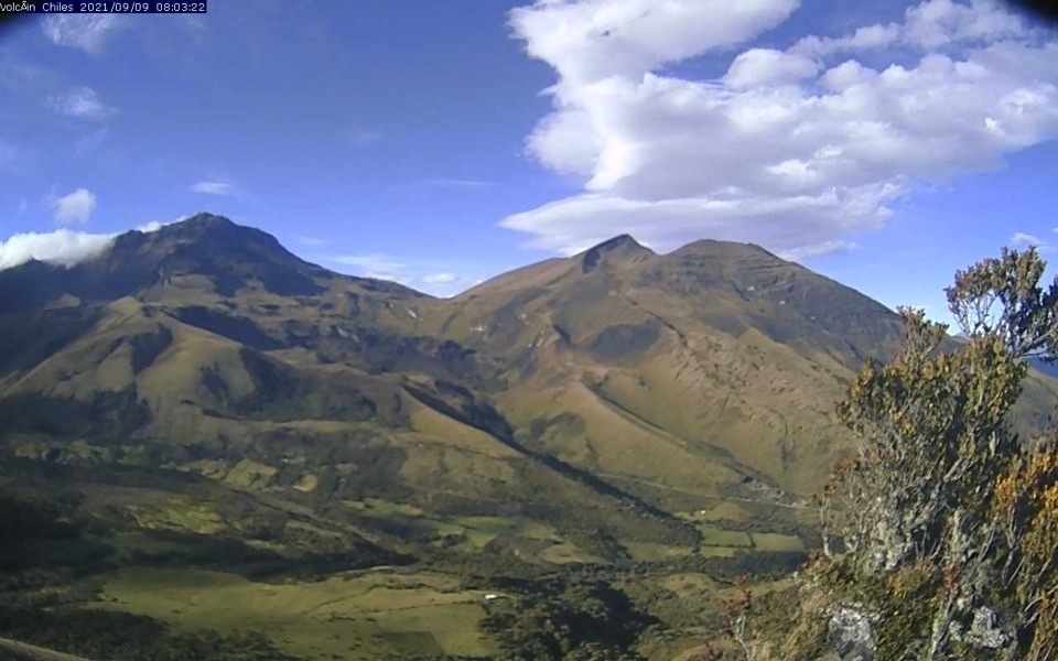
The second source was located southwest of the summit of Chiles Volcano, at distances less than 4.0 km, with depths between 6 and 8 km and a maximum magnitude of 1.5. The event recorded on June 24 at 5:12 p.m. is highlighted, with a magnitude of 3.6, reported as felt by residents of the municipality of Cumbal.
Volcanic deformation processes recorded by sensors installed on the ground and by remote satellite sensors continue. The evolution of CVCCN activity is the result of
internal processes derived from the complex interaction between the magmatic system, the hydrothermal system and the geological faults of the area. Therefore, the probability of the occurrence of energetic earthquakes that can be felt by residents in the region of influence of the CVCCN persists.
Volcanic activity remains in a YELLOW ALERT state: active volcano with changes in the behavior of the base level of monitored parameters and other manifestations.
Source et photo : SGC