May 14 , 2024.
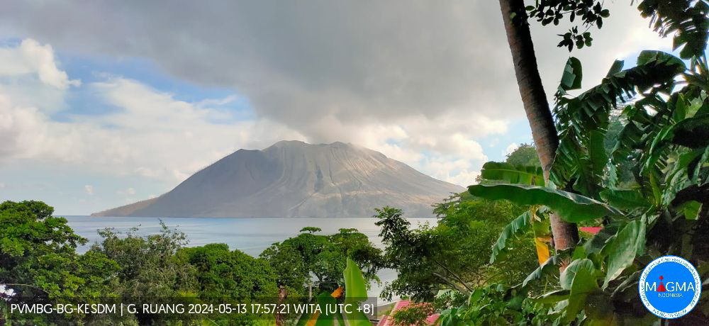
Indonesia , Ruang :
Decrease in G. Ruang activity level from level IV (AWAS) to level III (SIAGA).
Ruang Volcano is a stratovolcano type volcano and has a maximum height of 725 m above sea level (asl) while forming an island distinct from the other islands. Geographically, G. Ruang is located at the coordinate position 2° 18′ 14.19″ N and 125° 21′ 58.38″ E and administratively, it is in Tagulandang District, Sitaro Islands Regency, Province from North Sulawesi. Ruang Volcano was observed visually and instrumentally from the Volcano Observation Post (PGA) located in Tulusan Village, Tagulandang District, Sitaro Islands Regency, North Sulawesi Province.
The latest developments in G. Ruang’s activity until May 13, 2024 are as follows:
After the explosive eruption on April 17, 2024, eruptive activity decreased. On April 22, 2024 at 09:00 WITA, the activity level of G. Ruang was lowered from level IV (AWAS) to level III (SIAGA).
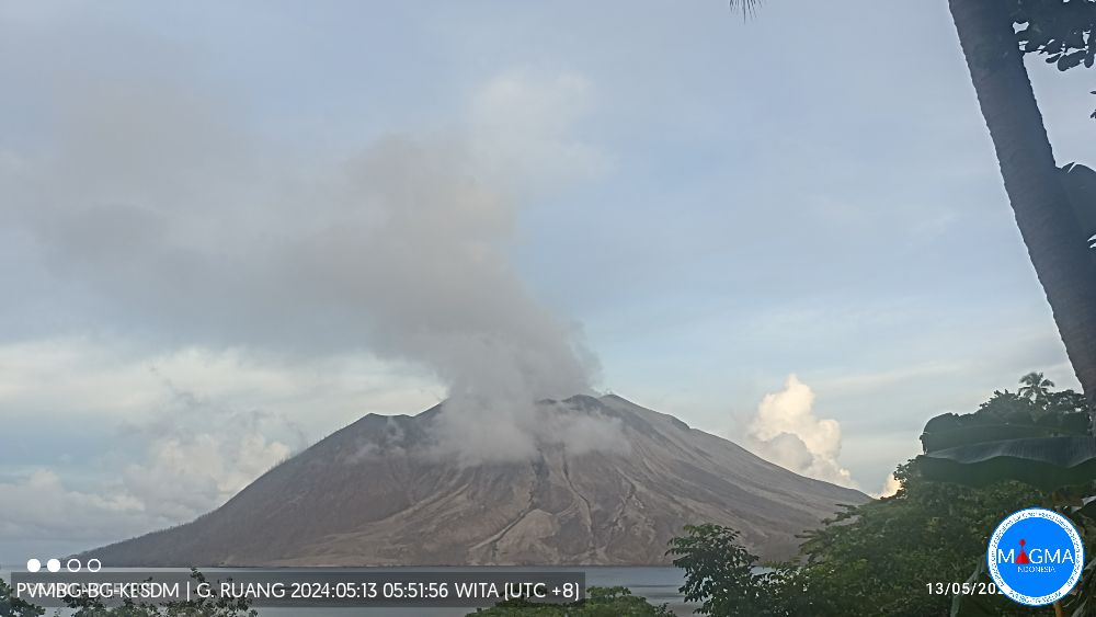
The earthquakes from April 29, 2024 until 24:00 WITA recorded via the RAPS station were: 15 avalanche earthquakes, 237 shallow volcanic earthquakes, 425 deep volcanic earthquakes, 15 local tectonic earthquakes and 6 distant tectonic earthquakes. Smoke from the crater was observed up to 200 to 1,000 m above the summit with a thick white color. At 17:02 WITA, a weak eruption was observed with smoke coming from the crater up to 1,000 m above the summit.
On April 30, 2024 at 01:15 WITA, an eruption occurred, starting as an earthquake felt as far away as Tagulandang Island, with a gray, medium-to-thick eruption column tilted toward the north . The height of the eruptive column reached 2,000 m above the summit. The activity level of G. Ruang was increased from level III (SIAGA) to level IV (AWAS) at 01:30 WITA, with a recommended danger distance within 6 km. At 09:00 WITA, the recommended danger distance was extended to 7 km.
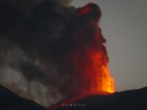
On April 30, 2024 at 02:32 WITA, there was another eruption followed by a roar. The height of the eruptive column was not observed due to darkness. It was reported that stone showers occurred at the Ruang PGA post in P. Tagulandang. The eruption lasted until 04:30 WITA. G. Ruang’s seismic monitoring equipment (RAPS) was damaged. At 08:35 WITA, an eruption was observed accompanied by a flow of hot clouds which reached the sea in the northeast sector of the island. The eruptive column measured ± 5,000 m in height from the summit, gray to black in color, thick in intensity leaning towards the East and South.
The eruptions of April 17, 2024 and April 30, 2024 damaged the RUA3 (1.5 km from the active crater) and RAPS (2.7 km from the active crater) stations located on the island of G. Ruang. On May 3, 2024, new monitoring equipment was installed on Ruang Island (RUA4) at a distance of 2 km from the active crater. This RUA4 station allows you to calculate current seismic activity.
Visual observations for the period May 1 to 12, 2024.
The smoke from the crater was observed to be white with thick intensity, low pressure, and a height of 100 to 400 m above the crater summit. However, the height is starting to show a stable trend. On May 13, 2024, smoke from the crater was observed to be white, with thick intensity, low pressure, and a height of 200–300 m above the crater summit.
The number of deep volcanic earthquakes and shallow volcanic earthquakes for the period May 1-12, 2024 (after the April 30, 2024 eruption) tends to decrease. Continuous tremors were still recorded, with the dominant amplitude decreasing in the range of 2 to 4 mm.
Seismicity from May 13, 2024 until 06:00 WITA recorded 1 emission earthquake, 1 distant tectonic earthquake and continuous tremors with a dominant amplitude of 2 mm.
The current potential danger comes in the form of eruptions which produce ejections of incandescent material and exposure to volcanic ash which depends on wind direction and speed and lahars if heavy rain falls on Mount Ruang.
Based on the results of visual and instrumental monitoring, the volcanic activity of Mount Ruang is still high and is set at level III (SIAGA).
Source et photo : PVMBG
Iceland , Reykjanes Peninsula :
The land is rising in Svartsengi at the same speed as before. A strong solar storm affected measurements this weekend
Updated May 13, 2024 at 11:35 a.m.
Increased likelihood of another magma flow and eruption in the coming days
Most Likely to Erupt: Sundhnúks Crater Series
Eruption warning may be very short
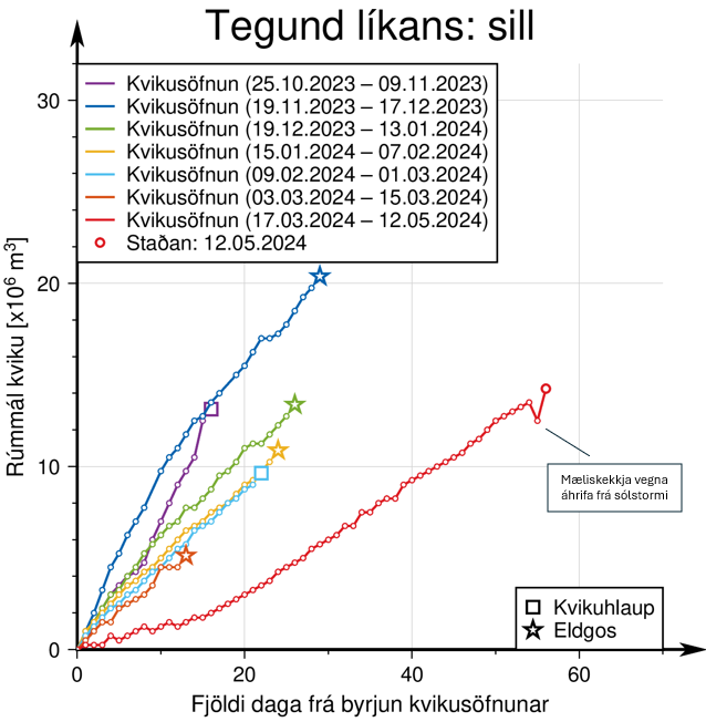
The land rises in Svartsengi with the same speed as before. Since March 16, when the last eruption began, the earth has risen almost 20 cm at the Svartsengi GPS station. Magma accumulation therefore continues and there is an increased risk of a new magma flow as well as an eruption.
During previous magma flows and eruptions, approximately 8 to 13 million cubic meters were added to the magma chamber beneath Svartsengi between events before magma flowed from the magma chamber into the Sundhnúks crater series. Now, the amount of magma added since March 16 has reached the upper limit.

Seismic activity is quite similar from one day to the next. Over the past week, around 50 to 80 earthquakes have been recorded per day, most of them in the areas between Stóra-Skógfell and Hagafell on the one hand and south of Þorbjarna on the other. Most earthquakes are less than 1.0 in magnitude, but occasional earthquakes close to 2.0 have been recorded. Signs of new magma flow would be the same as before, small local earthquakes in and around the magma tunnel, acceleration of deformation and pressure changes in boreholes in the area.
The National Weather Service’s 24-hour surveillance closely monitors activity. New fissures could open in the area between Stóra-Scógfell and Hagafell, and lava flows could become comparable to the initial phase of the last volcanic eruptions in the region. This could happen at very short notice, or even without notice.
A solar storm affected GPS measurements
Earth mass measurements are based on calculating changes in the time it takes for the signal to arrive from satellites orbiting the Earth to GPS meters on the ground. If the time it takes for the signal to travel between orbit and the counter decreases, it means the earth has risen.
Over the weekend, one of the most powerful magnetic storms in recent years occurred when solar winds the size of sunspots hit Earth. The last magnetic storm this powerful occurred on October 30, 2003.
Powerful solar winds send charged particles into the Earth’s magnetic field, affecting the transmission of signals between ground-based GPS instruments and satellites. This interference affects signal travel time and makes it appear as if magma buildup has been reduced. This is not the case since the new point calculated this morning is in a « normal » place compared to previous measurements. (See graph above).
Disruptions from solar storms do not affect the Met Office’s ability to warn of impending magma flows or eruptions.
Source : Vedur is.
Photos : RÚV – Webcam à Orbirn , Vedur.is
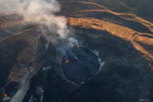
Ecuador / Galapagos , Fernandina :
DAILY REPORT ON THE ACTIVITY OF THE FERNANDINA VOLCANO. Quito, Monday May 13, 2024.
From May 12, 2024 11:00:00 to May 13, 2024 11:00:00
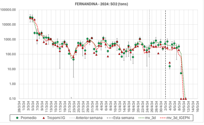
Quantity of sulfur dioxide measured since the end of January 2024 on the Fernandina volcano
Activity level:
Surface: Bottom; Surface trend: Descending
Internal: Low; Internal trend: Descending
Gas:
Since May 8, satellites have not detected any sulfur dioxide (SO2) emissions from Fernandina, so it is assumed that the eruption is nearing its end.
Other monitoring parameters:
Over the past 24 hours, the FIRMS satellite system recorded 39 thermal anomalies.
Observation:
Thanks to GOES-16 satellite images, remaining thermal anomalies are still observed on the volcano.
Source : IGEPN
Photos : IGEPN , Wanderlist Vacations .
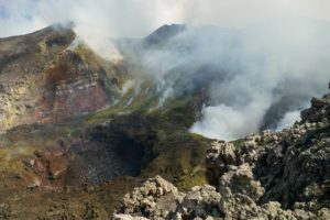
Indonesia , Ili Lewotolok :
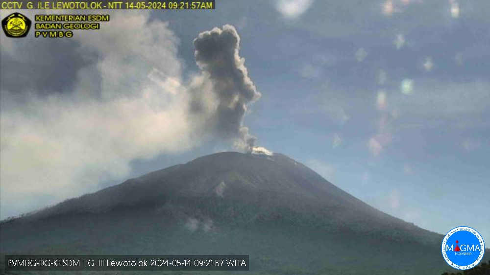
An eruption of Mount Ili Lewotolok occurred on Tuesday, May 14, 2024 at 09:12 WITA with the height of the ash column observed at ± 800 m above the summit (± 2223 m above sea level). The ash column was observed to be white, gray to black with thick intensity, oriented towards the South-West. At the time of writing, the eruption was still ongoing.
VOLCANO OBSERVATORY NOTICE FOR AVIATION – VONA
Issued : May 14 , 2024
Volcano : Ili Lewotolok (264230)
Current Aviation Colour Code : ORANGE
Previous Aviation Colour Code : orange
Source : Ili Lewotolok Volcano Observatory
Notice Number : 2024LEW004
Volcano Location : S 08 deg 16 min 19 sec E 123 deg 30 min 18 sec
Area : East Nusa Tenggara, Indonesia
Summit Elevation : 4554 FT (1423 M)
Volcanic Activity Summary :
Eruption with volcanic ash cloud at 01h12 UTC (09h12 local).
Volcanic Cloud Height :
Best estimate of ash-cloud top is around 7114 FT (2223 M) above sea level or 2560 FT (800 M) above summit. May be higher than what can be observed clearly. Source of height data: ground observer.
Other Volcanic Cloud Information :
Ash cloud moving to southwest. Volcanic ash is observed to be white to dark. The intensity of volcanic ash is observed to be thick.
Remarks :
Eruption and ash emission is continuing. Eruption recorded on seismogram with maximum amplitude 34.5 mm.
Source et photo : Magma Indonésie.
Guatemala , Santiaguito :
START OF THE LAHARES SEASON ON THE SANTIAGUITO VOLCANO
Guatemala, May 11, 2024, 11:00 a.m. (local time)
14 °44’ 33 ̋ North latitude:
91°34’13 ̋West longitude
Altitude: 2500 meters
In continuation of the monthly climate forecasts and outlook of the Department of Meteorological Research and Services, which indicate that between May 6 and 13, the rainy season can be formally established in the Bocacosta area, as well as rain records during The first day of this month, at the Santa María-Santiaguito Volcanic Complex Observatory, the Volcanology section reports on the start of the lahar season on the Santiaguito volcano.
When rain falls several days in a row on the deposits of volcanic material, it mixes with the water producing a flow of debris which transports mud, blocks of rock from a few centimeters to several meters in diameter, trunks and tree branches and almost anything he can find in his path.
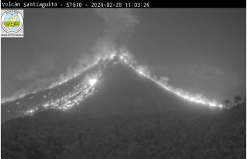
During the night and early in the morning, an incandescence is recorded on the dome of the dome and on the sides, caused by the descent of avalanches with high temperature blocks
The high level of volcanic activity on the Caliente dome, described in the special volcanological bulletin BESAN-004-2024 and in the daily volcanological bulletins, has caused the accumulation of volcanic material (ash, lapilli and boulders) on the southern flanks -West, South and South-East of the dome, as well as on the plain or “beach” located between the Caliente dome and the wall of the Santa María volcano. Thus, the upper parts of the Zanjón Seco, San Isidro and Cabello de Ángel canals are filled with materials likely to be washed away by rains in the form of lahars. These channels flow into the Tambor and Nimá I rivers, which in turn flow into the Samalá river, which allows lahars to travel from the area of El Palmar, Quetzaltenango, to the surroundings of San Sebastián, Retalhuleu.
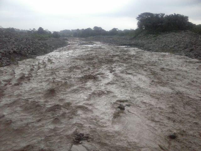
The first lahars of the season are expected to be particularly large and descend in the form of hot mudflows and abundant boulders, accompanied by water vapor and sulfur odors. These flows make it impossible to cross the canals and the materials they leave behind prevent the passage of vehicles and people for hours or days after the event, potentially leaving communities incommunicado by blocking passage through their waterways. usual transit or evacuation.
Source et photos : Insivumeh