March 30 , 2024.
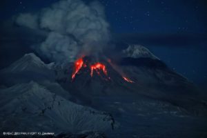
Ecuador / Galapagos Islands , Fernandina :
DAILY REPORT ON THE ACTIVITY OF THE FERNANDINA VOLCANO. Quito, Friday March 29, 2024.
From March 28, 2024 11:00:00 to March 29, 2024 11:00:00
Activity level:
Surface: Moderate; Surface trend: No changes
Internal: Moderate; Internal trend: No changes
Gas:
The Mounts satellite system reported 1,295.9 tonnes of sulfur dioxide (SO2) on 03/28/2024 measured at 1:56 p.m. TL.
Other monitoring parameters:
The FIRMS satellite system recorded 30 thermal anomalies, the MIROVA-MODIS satellite system recorded 3 high and 1 moderate thermal anomalies, and the MIROVA-VIIRS system recorded 2 high and 2 moderate thermal anomalies in the last 24 hours.
Observation:
Yesterday afternoon, at the time of writing this report, thanks to the GOES-16 satellite system, slight thermal anomalies were recorded.
Source : IGEPN
Photo : Javier Tenempaguay via Sherine France.
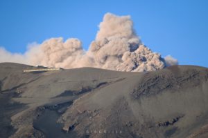
Italy / Sicily , Etna :
Press release on the activity of ETNA, March 29, 2024, 09:34 (08:34 UTC).
The National Institute of Geophysics and Volcanology, Osservatorio Etneo, communicates that the INGV-OE surveillance camera network shows the usual degassing of the summit craters, in particular the Bocca Nuova and Southeast craters. No signs of continued eruptive activity are observed.
The trend in the average amplitude of the volcanic tremor reflects what has been observed in recent days, that is to say a fluctuating trend, mainly in the average values, to which are sometimes added high values.
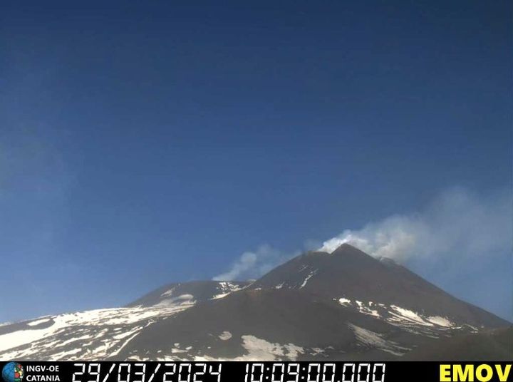
When recording the 5.8 magnitude earthquake with its epicenter on the Greek coast, a sudden increase in average amplitude was observed. The location of the centroid of tremor sources remains stable in the Southeast crater area at an altitude of approximately 2900 m above sea level.
The low infrasound activity linked to the degassing processes of Bocca Nuova continues.
Analysis of data from tilt, deformation and GNSS networks does not currently show significant ground deformations.
Further updates will be communicated shortly.
Source et photo : INGV.
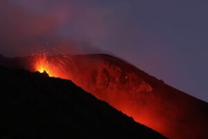
Aleutian Islands , Atka :
A small explosion occurred at the summit of Korovin volcano, one of the volcanoes in the Atka volcanic complex, on Wednesday March 27 at 19:36 AKDT (03:36 UTC March 28). It was detected in local infrasound and seismic data and was followed by a few minutes of elevated seismic tremor. Since then, seismic activity has continued to be above background. Satellite and web-camera views have been mostly obscured by clouds since the explosion, but a few clearer looks suggest that it did not produce significant ash.
View of the southwest flank of Korovin volcano. Photo from station 19AAJRS016, lower « Big Pink » ridge line.
AVO increased the Aviation Color Code to YELLOW and the Volcano Alert Level to ADVISORY Wednesday following the explosion. AVO continues to carefully monitor for signs of additional unrest that could lead to an eruption. The Atka volcanic complex is monitored by local seismic and infrasound sensors and webcam, satellite data, and regional lightning detection instruments.
Source : AVO
Photo : Schaefer, Janet / / courtesy of the AVO/ADGGS.
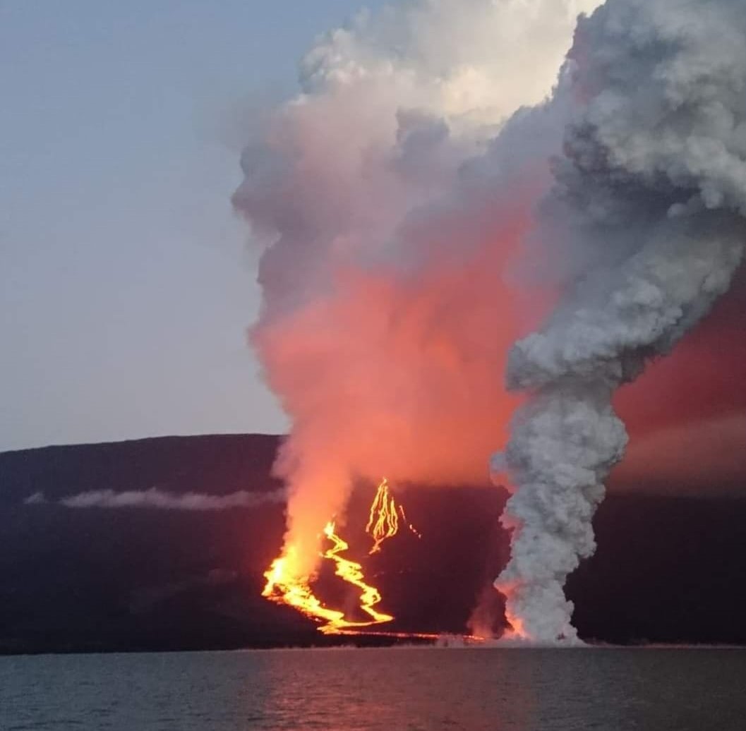
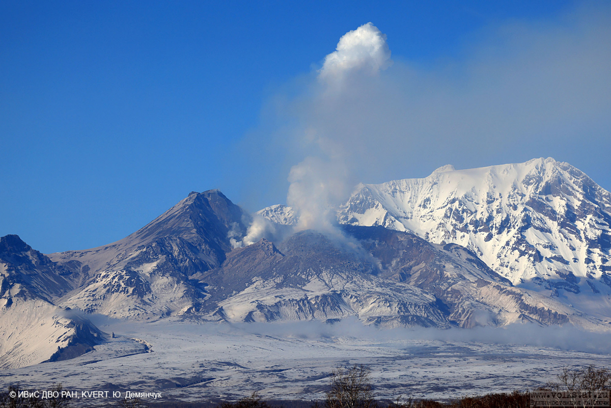
Kamchatka , Sheveluch :
VOLCANO OBSERVATORY NOTICE FOR AVIATION (VONA)
Issued: March 30 , 2024.
Volcano: Sheveluch (CAVW #300270)
Current aviation colour code: ORANGE
Previous aviation colour code: orange
Source: KVERT
Notice Number: 2024-16
Volcano Location: N 56 deg 38 min E 161 deg 18 min
Area: Kamchatka, Russia
Summit Elevation: 3283 m (10768.24 ft), the dome elevation ~2500 m (8200 ft)
Volcanic Activity Summary:
Video and satellite data by KVERT shows a strong wind lifts ash from the southern slopes of Sheveluch volcano, and a plume of resuspended ash is extending about 65 km to the eastsouth-east of the volcano.
An extrusive-effusive eruption of the volcano continues. A danger of ash explosions up to 6 km (19,700 ft) a.s.l. remains. Ongoing activity could affect low-flying aircraft.
Volcanic cloud height:
2000-2500 m (6560-8200 ft) AMSL Time and method of ash plume/cloud height determination: 20240330/0210Z – Video data
Other volcanic cloud information:
Distance of ash plume/cloud of the volcano: 65 km (40 mi)
Direction of drift of ash plume/cloud of the volcano: E / azimuth 99 deg
Time and method of ash plume/cloud determination: 20240330/0130Z – Himawari-9 14m15
Remarks: resuspended ash
Source : Kvert
Photo : Yu. Demyanchuk, IVS FEB RAS, KVERT
Colombia , Chiles / Cerro Negro :
Weekly Activity Bulletin: Chiles Volcanic Complex and Cerro Negro (CVCCN)
Regarding the monitoring of the activity of the CHILES AND CERRO NEGRO VOLCANOES, the MINISTRY OF MINES AND ENERGY, through the COLOMBIAN GEOLOGICAL SERVICE (SGC), reports that:
During the week of March 19-25, 2024, there was a slight increase in the frequency of earthquakes and a decrease in the energy released compared to the previous week.
The predominant seismicity continues to be linked to the fracture of the rocks of the volcanic edifice, although there remains the presence of earthquakes associated with the movement of fluids inside these volcanoes, some of them with contents of very low frequency.

The fracture earthquakes were located in two groups: the first in the South-Southeast quadrant of the Chiles volcano, at distances less than 7 km, with depths between 2 and 8 km from its summit (4,700 m altitude) and a maximum magnitude of 1.7. The other group of earthquakes was located at the summit of the Chiles volcano, with depths less than 6 km compared to its summit (4,700 m above sea level) and magnitudes less than 0.5.
Volcanic deformation processes recorded by sensors installed on the ground and by remote satellite sensors continue. The evolution of activity in the CVCCN is the result of internal processes derived from the complex interaction between the magmatic system, the hydrothermal system and the geological faults of the area. Thus, the probability of the occurrence of energetic earthquakes that could be felt by residents of the CVCCN zone of influence persists.
Volcanic activity remains in a YELLOW ALERT state: Active volcano with changes in the behavior of the base level of monitored parameters and other manifestations.
Source : SGC
Photo : IGEPN
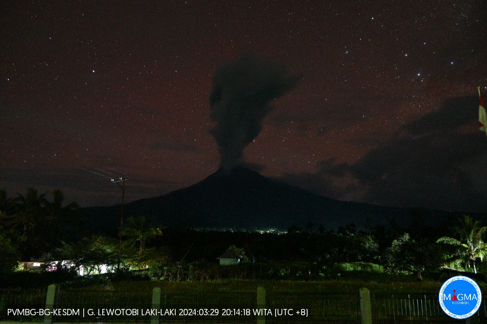
Indonesia , Lewotobi Laki Laki :
An eruption of Mount Lewotobi Laki occurred on Friday March 29, 2024 at 8:07 p.m. WITA with the height of the ash column observed at ±500 m above the summit (±2084 m above sea level). The ash column was observed to be white to gray in color with moderate to thick intensity, oriented towards the South and South-West. This eruption was recorded on a seismograph with a maximum amplitude of 7.4 mm and a duration of 372 seconds.
Observation of seismicity
2 eruption/explosion earthquakes with an amplitude of 4.4 to 7.4 mm and an earthquake duration of 104 to 332 seconds.
1 Avalanche earthquake with an amplitude of 7.4 mm and an earthquake duration of 72 seconds.
1 Harmonic tremor with an amplitude of 2.9 mm and an earthquake duration of 82 seconds.
1 Non-harmonic tremor with an amplitude of 1.4 mm and an earthquake lasting 207 seconds.
2 low-frequency earthquakes with an amplitude of 2.9 mm and an earthquake duration of 27 to 35 seconds.
1 hybrid/multi-phase earthquake with an amplitude of 2.9 mm, earthquake duration of 15 seconds.
3 Shallow volcanic earthquakes with an amplitude of 1.4 to 7.4 mm and an earthquake duration of 11 to 15 seconds.
7 deep volcanic earthquakes with an amplitude of 2.2 to 29.6 mm, and an earthquake duration of 9 to 19 seconds.
2 local tectonic earthquakes with an amplitude of 2.2 to 4.4 mm, duration of the earthquake 21 to 23 seconds.
5 distant tectonic earthquakes with an amplitude of 2.2 to 32.5 mm, and duration of the earthquake 29 to 88 seconds.
RECOMMENDATION
1. Communities around Mount Lewotobi Laki Laki and visitors/tourists do not carry out any activities within a radius of 2 km from the center of the eruption of Mount Lewotobi and in the sector of 3 km in the North-North-East direction and 5 km in the direction of the North East sector.
2. The public should remain calm and follow the instructions of the regional government and not believe rumors whose origin is unclear.
Source et photo : Magma Indonésie.