March 13 , 2024.
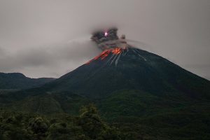
Italy , Stromboli :
WEEKLY NEWSLETTER. from March 4, 2024 to March 10, 2024. (issue date March 12, 2024)
SUMMARY STATEMENT OF ACTIVITY
In light of the monitoring data, it appears:
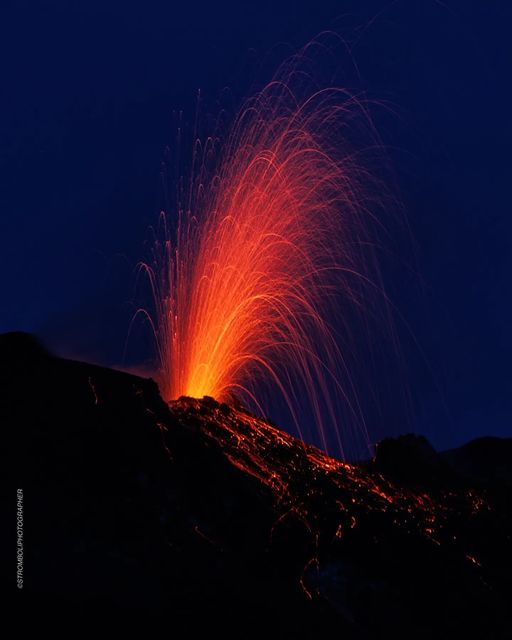
1) VOLCANOLOGICAL OBSERVATIONS: Normal Strombolian activity was observed during this period. The total hourly frequency was established at average values (9-14 events/h). The intensity of the explosions was low to medium in the North Crater area and low to high in the South-Central area.
2) SISMOLOGY: The monitored seismological parameters do not show significant variations.
3) GROUND DEFORMATIONS: The island’s ground deformation monitoring networks showed no significant changes to report for the period under review.
4) GEOCHEMISTRY: Mid-level SO2 flux.
There are no updates for the CO2 flux in the summit area.
C/S ratio in the plume: there are no updates.
Helium Isotope Ratio in Thermal Aquifer: There are no updates.
CO2 flow in Scari: remains at average values.
VOLCANOLOGICAL OBSERVATIONS
During the observed period, the eruptive activity of Stromboli was characterized through the analysis of images recorded by the INGV-OE surveillance cameras located at Pizzo (SPT), at 190 m altitude (SCT-SCV) and at Point dei Corvi. (SPCT). The explosive activity was mainly produced by 2 eruptive chimneys located in the northern zone of the crater and by 2 chimneys located in the South Central zone.
Due to the interruption of the video signal that occurred from 7:16 p.m. UTC on March 4 to 9:34 a.m. UTC on March 7, analysis of eruptive activity during this period was not carried out.
Observations of explosive activity captured by surveillance cameras
In the area of the North crater, with a mouth located in sector N1 and a mouth located in sector N2, explosive activity was observed mainly of low intensity (less than 80 m in height) in sector N2 and of intensity low and medium (less than 150 m height) up to sector N1. The products emitted in the eruption were mainly coarse materials (bombs and lapilli). The average frequency of explosions was variable, between 3 and 5 events/h.
In the South-Central (CS) zone, sectors C and S1 did not show significant activity. S2 explosions ranged in intensity from low (less than 80 m high) to high (more than 150 m high) with fine material sometimes mixed with coarse material. The average frequency of explosions varied between 5 and 10 events/h
Source : INGV.
Photo : Stromboli stati d’animo / Sebastiano Cannavo.
Russia / Kuril Islands , Ebeko :
VOLCANO OBSERVATORY NOTICE FOR AVIATION (VONA)
Issued: March 12 , 2024
Volcano: Ebeko (CAVW #290380)
Current aviation colour code: ORANGE
Previous aviation colour code: orange
Source: KVERT
Notice Number: 2024-12
Volcano Location: N 50 deg 41 min E 156 deg 0 min
Area: Northern Kuriles, Russia
Summit Elevation: 1156 m (3791.68 ft)
Volcanic Activity Summary:
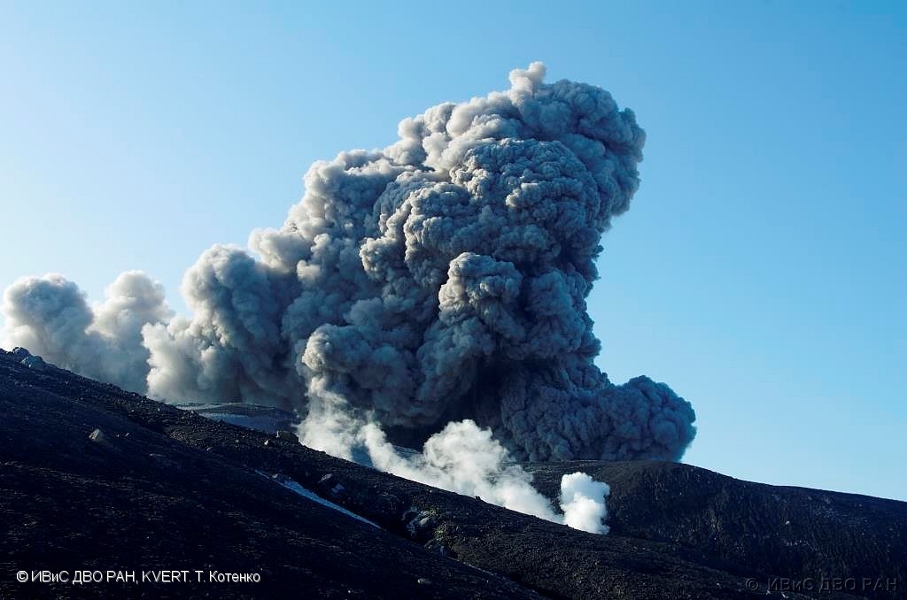
A moderate explosive eruption of the volcano continues. According to visual data from Severo-Kurilsk, explosions sent ash up to 2.5 km a.s.l., and ash cloud drifted to the north of the volcano.
A moderate explosive eruption of the volcano continues. Ash explosions up to 6 km (19,700 ft) a.s.l. could occur at any time. Ongoing activity could affect low-flying aircraft and airport of Severo-Kurilsk.
Volcanic cloud height:
2500 m (8200 ft) AMSL Time and method of ash plume/cloud height determination: 20240312/2108Z – Visual data
Other volcanic cloud information:
Distance of ash plume/cloud of the volcano: 10 km (6 mi)
Direction of drift of ash plume/cloud of the volcano: S
Time and method of ash plume/cloud determination: 20240312/2108Z – Visual data
Source : Kvert
Photo : T Totenko , ivs feb ras , kvert ( archive).
Colombia , Chiles / Cerro Negro :
Weekly activity bulletin of the Chiles and Cerro Negro Volcanic Complex (CVCCN)
Regarding the monitoring of the activity of the CHILES AND CERRO NEGRO VOLCANOES, the MINISTRY OF MINES AND ENERGY, through the COLOMBIAN GEOLOGICAL SERVICE (SGC), reports that:
During the week of March 5-11, 2024, at fluctuating levels, seismicity showed a decrease in both the number of events and the energy released. The predominance of earthquakes associated with the fracture of rocks inside the volcanic edifice remains, followed by seismicity linked to the movement of fluids. The earthquakes were located mainly to the south of the Chiles volcano, at distances of up to 4 km, with depths less than 7.0 km from its summit (4,700 m). The maximum magnitude recorded was 2.2 corresponding to an earthquake that occurred on March 9 at 3:41 a.m. No felt earthquakes were reported.
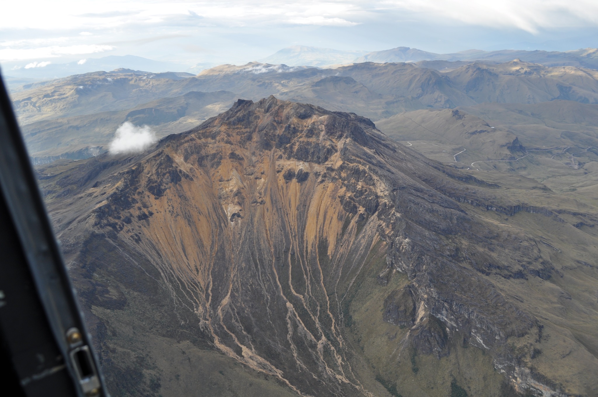
Surface deformation processes persist in the volcanic zone according to sensors installed on the ground and thanks to the processing of information from remote satellite sensors.
The evolution of activity in the CVCCN is the result of internal processes derived from the complex interaction between the magmatic system, the hydrothermal system and the geological faults of the area. Thus, the probability of the occurrence of energetic earthquakes that can be felt by residents of the CVCCN zone of influence continues.
Volcanic activity remains on YELLOW ALERT Status: Active volcano with changes in baseline behavior of monitored parameters and other manifestations
Source et photo : SGC
Hawaii , Kilauea :
Tuesday, March 12, 2024, 8:58 AM HST (Tuesday, March 12, 2024, 18:58 UTC)
19°25’16 » N 155°17’13 » W,
Summit Elevation 4091 ft (1247 m)
Current Volcano Alert Level: ADVISORY
Current Aviation Color Code: YELLOW
Activity Summary:
Kīlauea volcano is not erupting. Due to continued low rates of seismicity, HVO will issue weekly Kīlauea updates on Tuesdays until further notice. Additional messages will be issued as needed.
Summit Observations:
Low levels of seismicity beneath the summit continues. Earthquakes are dispersed widely from the summit to the southwest. There were 40 earthquakes recorded around the summit over the past week. Depths beneath the summit are 0.5-5 miles (1–8 km) below the surface, and magnitudes are typically below M2.0.
Ground deformation remains low with tiltmeters near Uēkahuna and Sand Hill showing only modest changes over the past week.
Sulfur dioxide (SO2) gas emission rates have remained low since October 2023. An SO2 emission rate of approximately 85 tonnes per day was recorded on March 1.
Rift Zone Observations:
Seismicity in Kīlauea’s upper East Rift Zone and Southwest Rift Zone remain low. No unusual activity has been noted along the middle and lower sections of Kīlauea’s East Rift Zone. We continue to closely monitor both rift zones.
Source : HVO
Photo : USGS / K. Mulliken.
Mexico , Popocatepetl :
March 12, 11:00 a.m. (March 12, 5:00 p.m. GMT). Activity from the last 24 hours
43 low-intensity exhalations were detected and 1,294 minutes of high-frequency, low-amplitude tremors were identified. Both volcanic events were accompanied by water vapor, other gases and ash.
Cenacom (National Center for Communications and Civil Protection Operations) reported yesterday a light ash fall in the municipalities of the capital Puebla, San Pedro Cholula, San Andrés Cholula, Cuautlancingo, Amozoc, San Nicolás de los Ranchos, Calpan, Huejotzingo, Domingo Arenas, Tlaltenango, San Martín Texmelucan and Santiago Miahuatlán, in the state of Puebla as well as in the state of Tlaxcala. Today it was reported that operations at Puebla’s Hermanos Serdán International Airport were suspended as of 7 a.m. . Cleaning work was carried out on the runway, taxiing and platforms.
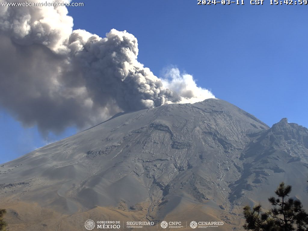
During this morning and at the time of this report, an emission of volcanic gases and ash is observed, with dispersion towards the North-East (NE).
The Popocatépetl volcanic warning fire is in yellow phase 2.
The scenarios planned for this phase are:
A few small to moderate explosions
Appearance of tremors of variable amplitude.
Source : Cenapred.