February 18 , 2024.
Indonesia , Marapi :
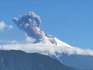
Mount Marapi erupted on Friday, February 16, 2024 at 11:18 WIB. The height of the eruptive column was not observed. The eruption was recorded on a seismograph with a maximum amplitude of 30.2 mm and a duration of 43 seconds.
SEISMICITY OBSERVATIONS:
52 earthquakes. emissions with an amplitude of 2 to 6.3 mm and duration of the earthquake from 43 to 184 seconds.
2 low-frequency earthquakes with an amplitude of 2.4 to 3.3 mm and an earthquake duration of 17 seconds.
2 Shallow volcanic earthquakes with an amplitude of 1.4 to 2.3 mm and an earthquake duration of 7 to 8 seconds.
1 Distant tectonic earthquake with an amplitude of 4.7 mm, and the earthquake lasted 77 seconds.
1 Continuous tremor with an amplitude of 0.5 to 3 mm, dominant value of 1 mm.
Recommendation
1. Communities around Mount Marapi and climbers/visitors/tourists should not enter and conduct activities within a 4.5 km radius of the eruption center (Verbeek crater) of Mount Marapi.
2. Communities living around the valleys/streams/river banks that originate at the top of Mount Marapi should always be aware of the potential threat of lahars that may occur, especially during the rainy season.
Source : Magma Indonésie.
Photo : Dody.bukittinggi
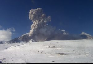
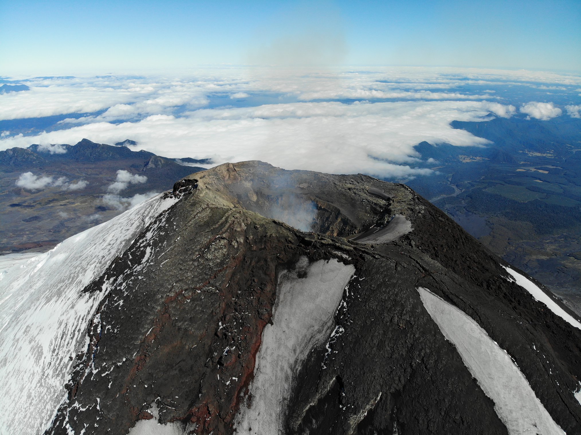
Chile , Villarica :
Special Report on Volcanic Activity (REAV), La Araucanía and Los Ríos regions, Villarrica volcano, February 17, 2024, 03:00 local time (mainland Chile)
The National Geology and Mining Service of Chile (Sernageomin) announces the following PRELIMINARY information, obtained through the monitoring equipment of the National Volcanic Monitoring Network (RNVV), processed and analyzed at the Southern Andean Volcano Observatory (Ovdas):
On Saturday February 17, 2024, at 02:28 local time (05:28 UTC), monitoring stations installed near the Villarrica volcano recorded an earthquake associated with fluid dynamics inside the volcanic system (long-period type).
The characteristics of this earthquake after its analysis are as follows:
ORIGINAL TIME: 02:28 local time (05:28 UTC)
REDUCED TRAVEL: 85.1 (cm*cm)
ACOUSTIC SIGNAL: 2.6 Pascals (Pa) reduced to 1 km
Observation :
The unfavorable weather conditions in the area made it impossible to observe surface activity. At the time of this report, the monitoring parameters do not show any variations.
The technical volcanic alert is maintained at YELLOW level.
Source : Sernageomin
Photo : Take a Way ( 2020).
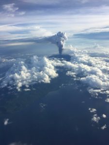
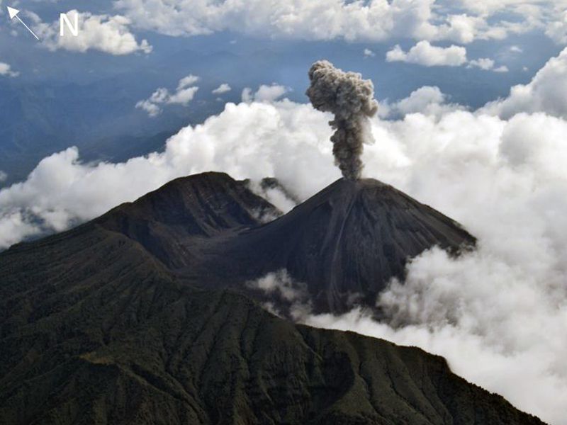
Ecuador , Reventador :
DAILY REPORT ON THE STATE OF THE REVENTADOR VOLCANO, Saturday February 17, 2024.
Information Geophysical Institute – EPN.
Surface activity level: Moderate, Surface trend: No changes
Internal activity level: Moderate, Internal trend: No changes
Seismicity: From February 16, 2024, 11:00 a.m. to February 17, 2024, 11:00 a.m.:
The following table shows the number of seismic events from the reference station in the last 24 hours.
Explosion (EXP) 41
Long Period (LP) 12
Transmitting tremor (TREMI) 11
Precipitation/Lahars:
Rain was recorded in the volcano area, generating small flows of mud and debris. In the event of heavy rains, these could remobilize the accumulated materials, generating mud and debris flows which would descend the sides of the volcano and flow into adjacent rivers.
Emissions/ash column:
Since yesterday afternoon, at the time of writing this report, thanks to the surveillance camera system, due to the climatic conditions of the area, it has not been possible to record gas or ash emissions.
Observation:
In the afternoon and evening from yesterday until this morning, according to the surveillance camera system and GOES – 16, the volcano remained partly to completely cloudy.
Alert level: Orange.
Source : IGEPN.
Photo : f-Naranjo , GVP.
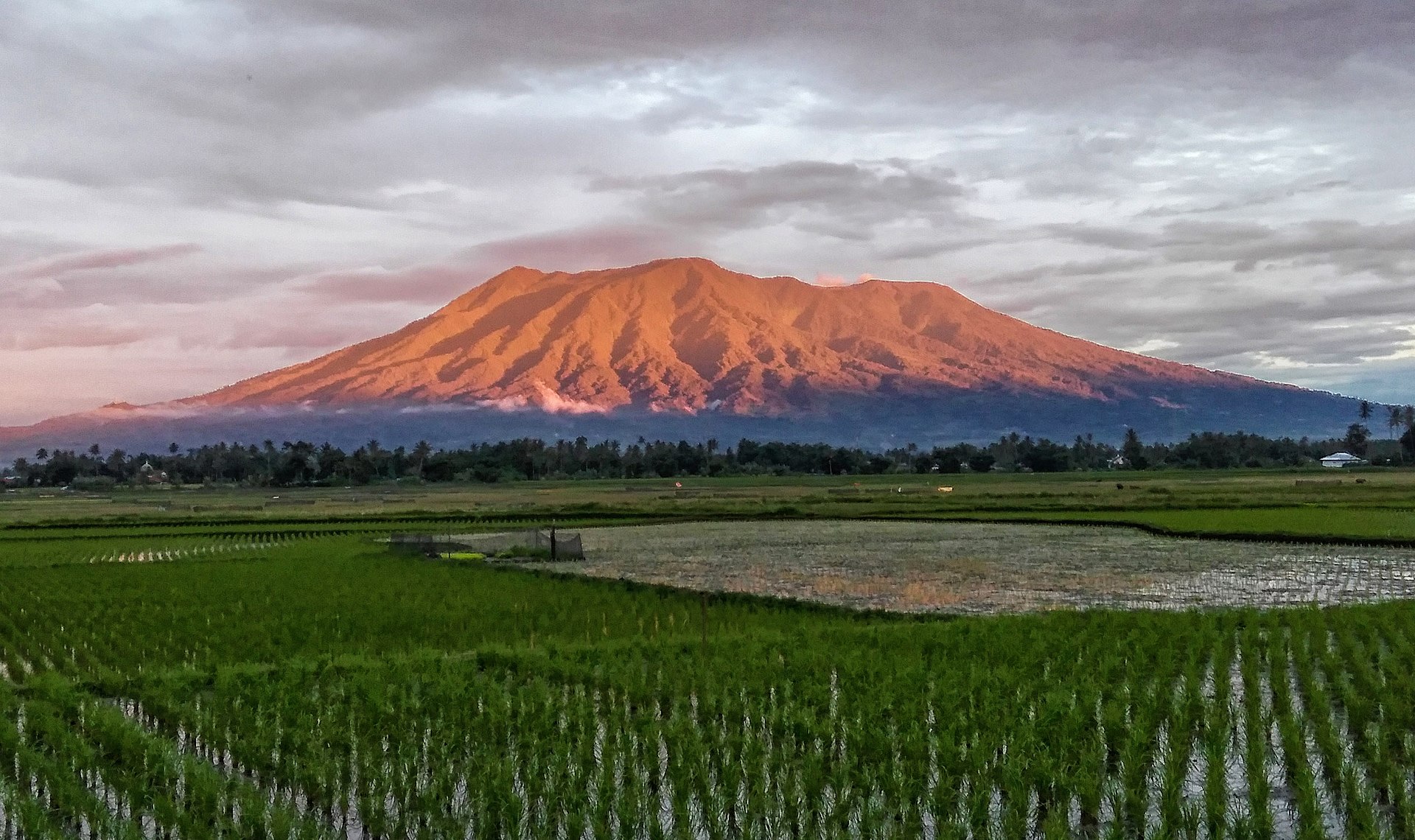
Alaska , Shishaldin :
AVO/USGS Volcanic Activity Notice
Current Volcano Alert Level: ADVISORY
Previous Volcano Alert Level: WATCH
Current Aviation Color Code: YELLOW
Previous Aviation Color Code: ORANGE
Issued: Saturday, February 17, 2024, 11:26 AM AKST
Source: Alaska Volcano Observatory
Notice Number: 2024/A176
Location: N 54 deg 45 min W 163 deg 58 min
Elevation: 9373 ft (2857 m)
Area: Aleutians
Volcanic Activity Summary:
Shishaldin Volcano is not showing any signs of ongoing ash emissions or eruptive activity. Seismicity remains elevated with ongoing volcanic earthquakes, but there is no indication of explosive activity or the presence of lava in the crater. The current activity is consistent with continued volcanic unrest but not an active eruption, and AVO is lowering the Aviation Color Code to YELLOW and Volcano Alert Level to ADVISORY.

The last significant eruptive activity was in November 2023.
Shishaldin Volcano is monitored by local seismic and infrasound sensors, web cameras, and a telemetered geodetic network. In addition to the local monitoring network, AVO uses nearby geophysical networks, regional infrasound and lighting data, and satellite images to monitor the volcano.
Remarks:
Shishaldin Volcano, located near the center of Unimak Island in the eastern Aleutian Islands, is a spectacular symmetric cone with a base diameter of approximately 10 miles (16 km). A 660 ft. (200 m) wide funnel-shaped summit crater typically emits a steam plume and occasional small amounts of ash. Shishaldin is one of the most active volcanoes in the Aleutian volcanic arc, with at least 54 episodes of unrest including over 26 confirmed eruptions since 1824. Most eruptions are relatively small, although the April-May 1999 event generated an ash column that reached 45,000 ft. (14 km) above sea level.
Source : AVO
Photo : Nick Enloe. ( archive)
Hawaii , Kilauea :
Saturday, February 17, 2024, 9:05 AM HST (Saturday, February 17, 2024, 19:05 UTC)
19°25’16 » N 155°17’13 » W,
Summit Elevation 4091 ft (1247 m)
Current Volcano Alert Level: ADVISORY
Current Aviation Color Code: YELLOW
Activity Summary:
Kīlauea volcano is not erupting. Low to moderate rates of seismicity at the summit and along the Koaʻe fault system southwest of the summit continues following an intrusion of magma into the area at the end of January.
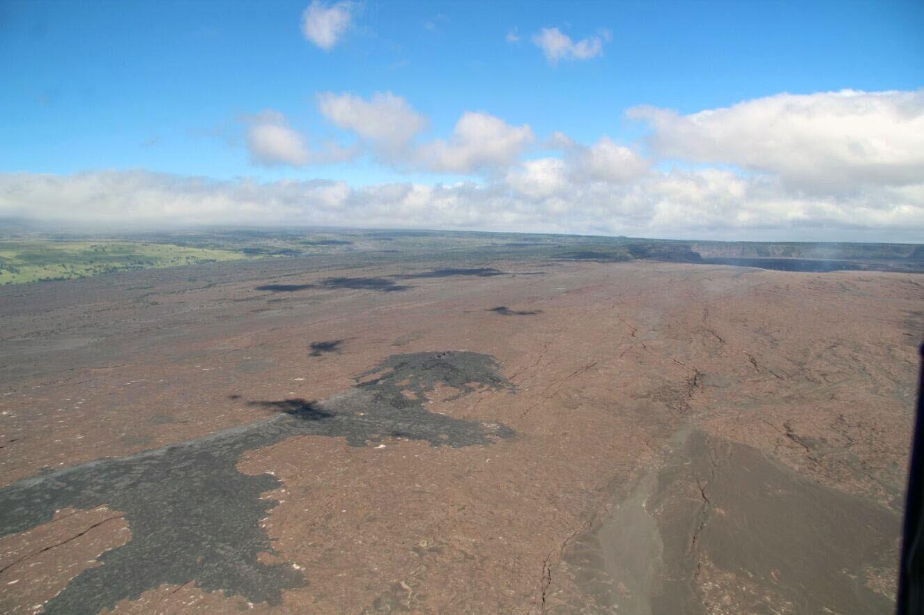
On February 6, 2024, HVO geologists conducted an overflight of the Koa‘e fault system, south of Kīlauea caldera, and the Southwest Rift Zone to assess cracks observed by ground crews in the area over the weekend. This view shows lava flows from the 1971 Southwest Rift Zone eruption; Kīlauea caldera is visible to the northeast.
Summit Observations:
Seismicity beneath the summit and extending 5-7 miles (8-11 km) southwest of the caldera under the Koaʻe fault zone continues. Earthquakes are dispersed widely from the summit to the southwest. There were approximately 6 earthquakes recorded across this region over the past 24 hours. Depths remain consistent at 1–5 km (0.6-3 mi) below the surface, and magnitudes are typically below M2.0.
Ground deformation remains low with tiltmeters near Sand Hill and Uēkahuna bluff recording slight inflationary tilt over the past 24 hours, as part of an ongoing a DI event.
Sulfur dioxide (SO2) gas emission rates have remained low since October 2023. An SO2 emission rate of approximately 100 tonnes per day was recorded on February 16.
Source : HVO
Photo : USGS / H. Winslow.