March 15 , 2022 .
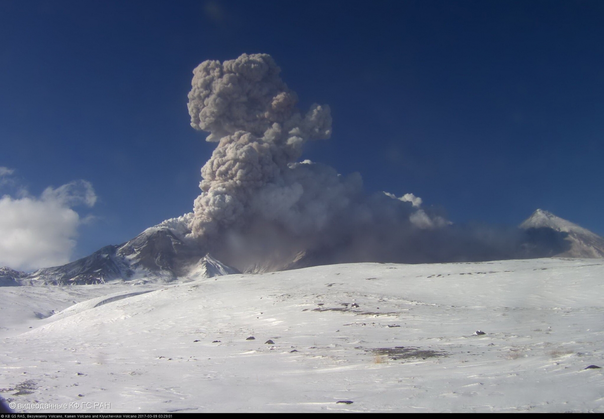
Kamchatka , Bezymianny :
VOLCANO OBSERVATORY NOTICE FOR AVIATION (VONA)
Issued: March 14 , 2022
Volcano: Bezymianny (CAVW #300250)
Current aviation colour code: ORANGE
Previous aviation colour code: yellow
Source: KVERT
Notice Number: 2022-16
Volcano Location: N 55 deg 58 min E 160 deg 35 min
Area: Kamchatka, Russia
Summit Elevation: 2882 m (9452.96 ft)
Volcanic Activity Summary:
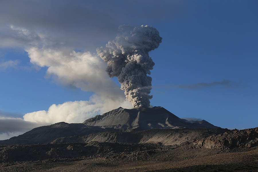
The activity of the volcano is gradually increasing. Probably, a new block of lava is squeezed out on the lava dome of the volcano, this is accompanied by the collapse of small avalanches. According to Tokyo VAAC and KVERT, a small ash cloud was formed at 1510 UTC on 14 March. An explosive volcanic eruption is possible with the removal of ash up to 15 km above sea level, the formation of pyroclastic flows and the spread of an ash cloud hundreds of kilometers from the volcano during next several days. KVERT continues to monitor the volcano.
The extrusive eruption of the volcano continues. Ash explosions up to 10-15 km (32,800-49,200 ft) a.s.l. could occur during next several days. Ongoing activity could affect international and low-flying aircraft.
Volcanic cloud height:
5000 m (16400 ft) AMSL Time and method of ash plume/cloud height determination: 20220314/1510Z – Himawari-8
Other volcanic cloud information:
Distance of ash plume/cloud of the volcano: 60 km (37 mi)
Direction of drift of ash plume/cloud of the volcano: W / azimuth 272 deg
Time and method of ash plume/cloud determination: 20220314/1700Z – Himawari-8
Start time of explosion and how determined: 20220314/1510Z – Satellite data
Source : Kvert.
Photo : videodata KB GS RAS , mars 2017
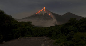
Peru , Sabancaya :
Analysis period: from March 07, 2022 to March 13, 2022, Arequipa, March 14, 2022.
Alert level: ORANGE
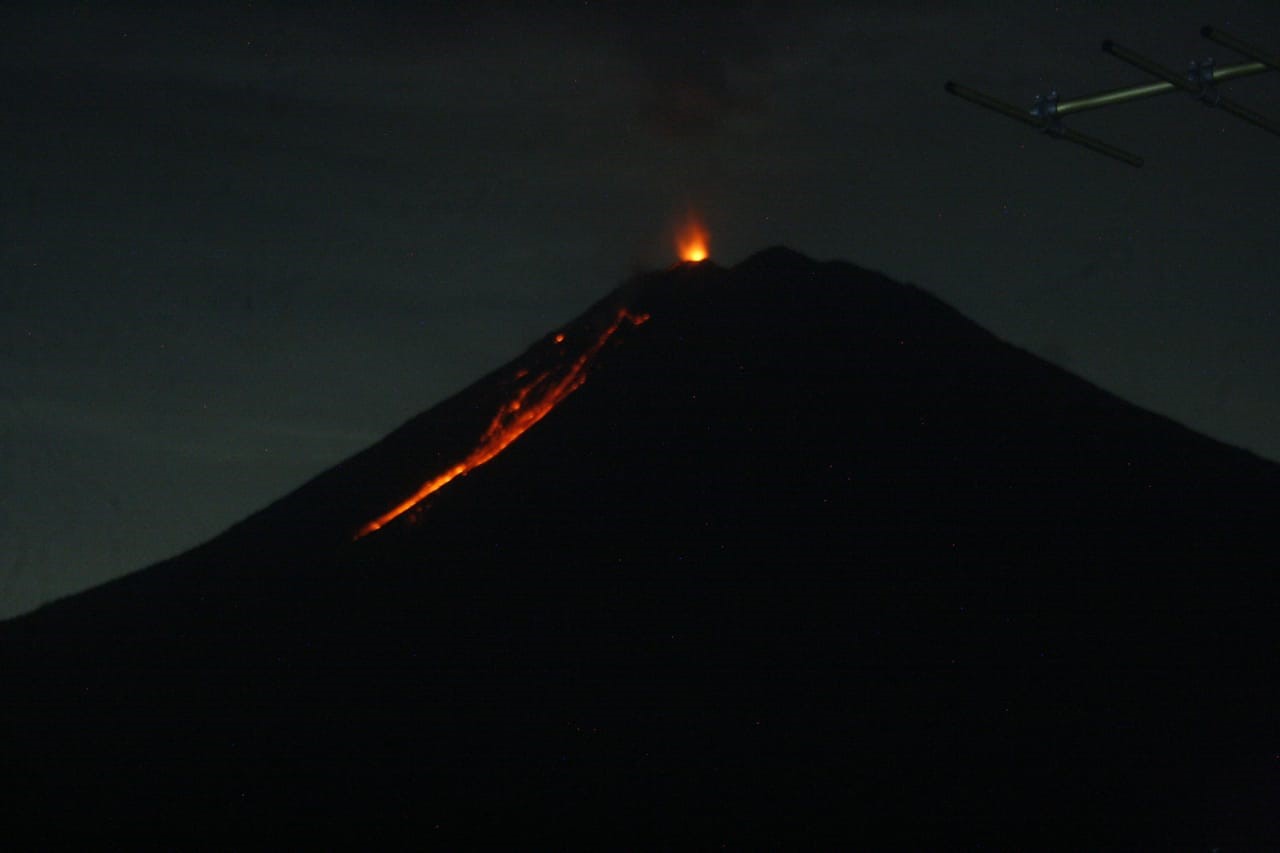
The Geophysical Institute of Peru (IGP) reports that the eruptive activity of the Sabancaya volcano remains at moderate levels, that is to say with the recording of an average of 29 daily explosions, with columns of ash and of gas up to 2.0 km altitude above the summit of the volcano and their subsequent dispersion. Therefore, for the following days, no significant change is expected in eruptive activity.
The IGP recorded and analyzed the occurrence of 139 earthquakes of volcanic origin, associated with the circulation of magmatic fluids inside the Sabancaya volcano. An average of 29 explosions was recorded daily. During this period, Volcano-Tectonic (VT) type earthquakes associated with rock fracturing were located mainly in the northeast and northwest of Sabancaya and presented magnitudes of M 2.4.
Monitoring the deformation of the volcanic structure using GNSS techniques (processed with fast orbits) does not show any significant anomalies. However, in general, an inflation process was observed in the northern sector (surroundings of the Hualca Hualca volcano). Visual surveillance identified columns of gas and ash up to 2.0 km above the summit of the volcano, which were scattered towards the western and northwest sectors of Sabancaya. Satellite recordings have identified the presence of 4 thermal anomalies, with a maximum value of 20 MW, associated with the presence of a lava body on the surface of the volcano’s crater.
RECOMMENDATIONS
• Keep the volcanic alert level orange.
• Do not approach within a radius of less than 12 km from the crater.
Source : CENVUL
Photo : Photovolcanica.
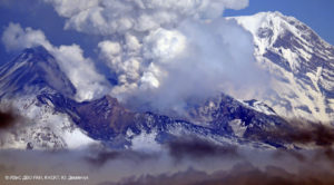
Indonesia , Semeru :
VOLCANO OBSERVATORY NOTICE FOR AVIATION – VONA
Issued : March 14 , 2022 .
Volcano : Semeru (263300)
Current Aviation Colour Code : ORANGE
Previous Aviation Colour Code : orange
Source : Semeru Volcano Observatory
Notice Number : 2022SMR61
Volcano Location : S 08 deg 06 min 29 sec E 112 deg 55 min 12 sec
Area : East java, Indonesia
Summit Elevation : 11763 FT (3676 M)
Volcanic Activity Summary :
Eruption with volcanic ash cloud at 22h10 UTC (05h10 local). Eruption and ash emission is continuing.
Volcanic Cloud Height :
Best estimate of ash-cloud top is around 26086 FT (8152 M) above sea level, may be higher than what can be observed clearly. Source of height data: ground observer.
Other Volcanic Cloud Information :
Ash-cloud moving to west.
The volcano was clearly visible until it was covered in fog. Smoke from the crater was not observed. The weather is sunny to rainy, the wind is weak in the South, South-West and West. The air temperature is around 22-30°C. An eruption was observed with an eruption column of 500-1000 m above the summit, gray-white in color, oriented towards the West and the South-West.
Earthquakes are related to magma and tectonic activity. It was recorded:
– 52 earthquakes of eruptions/explosions
– 3 emission earthquakes
– 2 deep volcanic earthquakes
– 5 distant tectonic earthquakes
Sources : Magma Indonésie , PVMBG.
Photo : PVMBG.
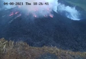
Hawaii , Kilauea :
19°25’16 » N 155°17’13 » W,
Summit Elevation 4091 ft (1247 m)
Current Volcano Alert Level: WATCH
Current Aviation Color Code: ORANGE
Activity Summary:
The summit eruption of Kīlauea Volcano, within Halemaʻumaʻu crater, continued over the past 24 hr. All recent activity has been confined to the smaller active lake within the crater, and there are no indications of activity migrating elsewhere on Kīlauea.
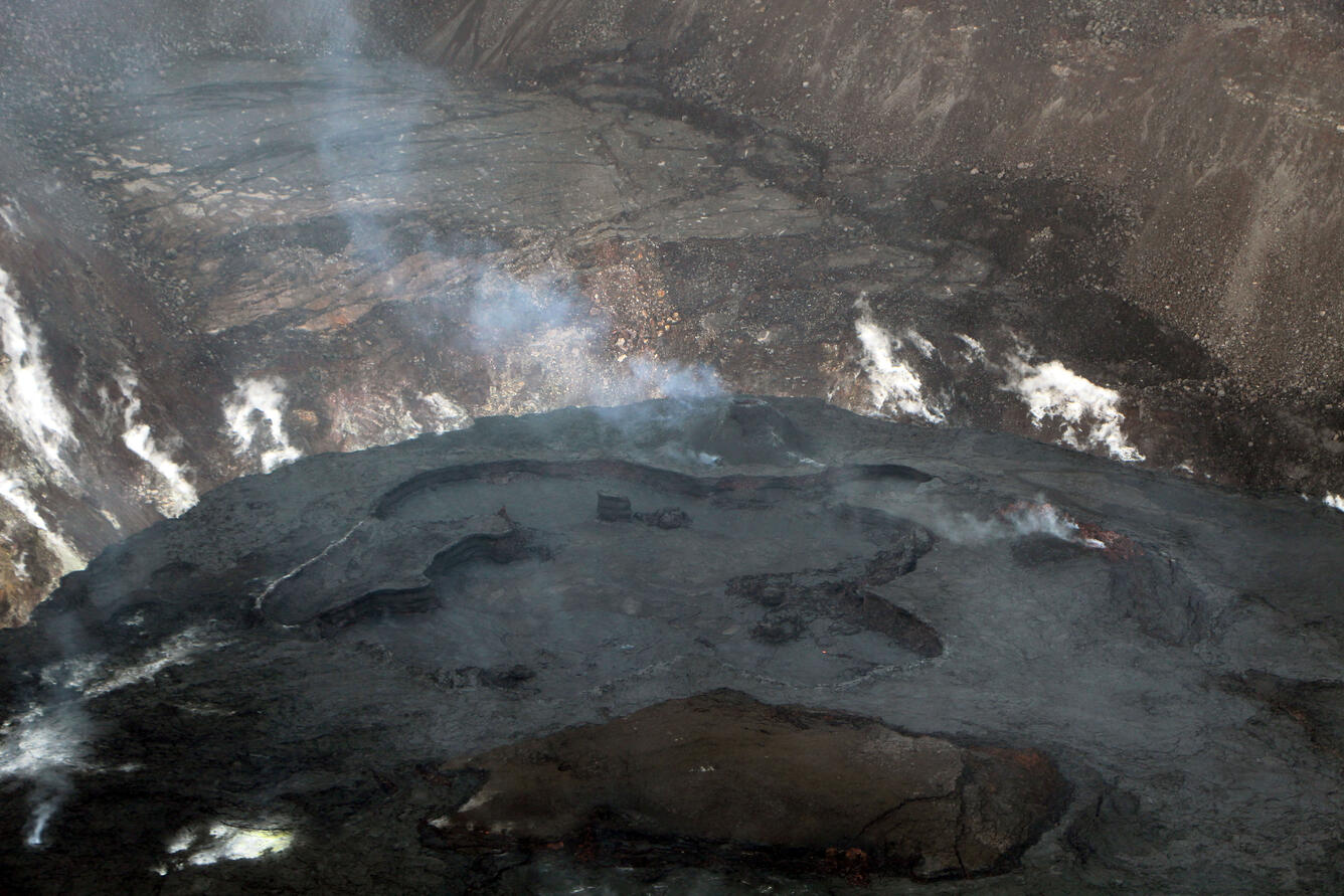
Halemaʻumaʻu Lava Lake Observations:
Eruption of lava from the western vent into the active lava lake surface (approximately 2.5% of Halemaʻumaʻu crater floor) continued through yesterday. The active western lava lake surface of Halema‘uma‘u crater has remained at a steady elevation over the past 24 hours, corresponding with continued slightly inflationary tilt for the past day. Minor and slow crustal overturning occurred on the northwest side of the crater floor edge throughout the day and also began on the southeast side of the crater floor edge, lasting for several hours yesterday afternoon.
Summit Observations:
Summit tilt yesterday continued a slightly inflationary trend through yesterday. Seismic data shows that the volcanic tremor is still elevated this morning and earthquake activity at the summit remains below background levels. A sulfur dioxide (SO2) emission rate of approximately 1900 tonnes per day (t/d) was measured on March 10.
Source : HVO
Photo : USGS / D. Downs.
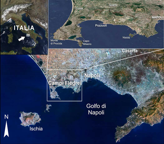
Italy , Campi Flegrei :
“Calderas are volcanic depressions formed by the collapse of rocks from the roof of the magma chamber which is emptied during huge eruptions”, explains Lucia Pappalardo, researcher at INGV and co-author of the study. They often manifest phases of “turmoil” (i.e. “imbalance”), with frequent earthquakes, uplift of the ground (called “bradyseism”) and considerable flow of gas and heat. However, as this activity is due to the complex interactions between the magma and the hydrothermal system stored under the volcano, it is always difficult to identify the source and to predict the evolution of these manifestations.
The study which has just been published has shown that the variations in the composition of fumarolic gases measured during the last decades at the level of the caldera of the Phlegraean Fields come from the depressurization and the crystallization of two main magmatic sources: a deep, located between 16 and 12 km below ground level, which fueled the bradyseismic crisis of 1982-84 by transferring a large volume of magma (3 km3) to the second source located about 8 km deep. The latter, on the other hand, fed fumarolic gases during the crisis which began in 2000 and which is currently still ongoing…/…
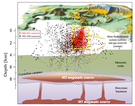
“Our study shows how gases released by rising magma in deep areas of the volcano’s feeder system accumulate at the base of the overlying hydrothermal system, located about 3 km deep, which is heated and pressurized, deforming and fracturing the most superficial crustal rocks and thus giving rise to phenomena of ground uplift and earthquakes generally observed in the region”.
Researchers examined the tiny magma droplets trapped in crystals of volcanic products emitted during Phlegrean eruptions over the past 15,000 years, reconstructing the architecture of the deep magma system in the Phlegraean Fields.
« Thanks to thermodynamic models, it has been possible to reproduce the scenarios of deep magmatic degassing which, in recent decades, have controlled the variations in the chemical composition and flow of fumarolic gases measured at Solfatara », adds Gianmarco Buono , INGV volcanologist and co-author of the research.
The study also suggests that the information obtained by combining petrological and geochemical data is essential for reconstructing the dynamics of magma transfer even when it affects hotter and therefore « silent » parts of the deep crust from a point of view. seismic, and can therefore have important implications for the definition of the best monitoring strategies.
During the month of February 2022 in the Campi Flegrei region, 246 earthquakes were recorded with a maximum magnitude = 2.2±0.3. Ground deformation monitoring networks confirm a radial lift geometry centered in the Pozzuoli region with an average velocity of about 13±2 mm/month. The lift recorded at the Rione Terra GPS station (RITE) since November 2005 is around 92 cm including around 58 cm from January 2016. The ground CO2 flux in the Solfatara region is confirmed at around 3000t / j, values comparable to those found in the plume of active volcanoes with persistent degassing.
Source : INGV.
Photos : INGV.