March 29 , 2018.
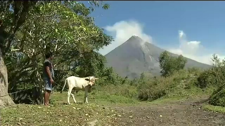
Ambae , Vanuatu :
The New Zealand Defence Force has conducted aerial surveys of two volcanoes in the Pacific that are showing signs of renewed activity.
The survey, requested by GNS Science, included Monowai, an underwater volcano north of New Zealand, and the Manaro Voui (Ambae) volcano in Vanuatu, Air Commodore Andrew Clark, the Air Component Commander, said.
“Imagery taken by a Royal New Zealand Air Force P-3K2 Orion aircraft will help authorities assess recent volcanic activity, especially of Manaro Voui volcano,” Air Commodore Clark said.
The eruption of Manaro Voui volcano started last September, prompting Vanuatu authorities to raise the volcanic alert level to 4 – the second-highest alert level – and to order all 11,000 residents of Ambae island to evacuate immediately. The residents returned when the level of volcanic activity subsided in October.
GNS Science said the vigour of Manaro Voui’s eruption increased over the past seven to 10 days, with fresh ash falling and acid rain reported, affecting crops, water supplies and some buildings.
GNS Science and New Zealand’s Ministry of Foreign Affairs and Trade are supporting the Vanuatu Meteorology and Geo-Hazards Department in responding to the eruption.
The Monowai submarine volcano in the northern Kermadec area is also frequently active and GNS Science found evidence of volcanic activity in seismic data in recent weeks.
GNS Science volcanologist Brad Scott said it was extremely important to monitor active volcanoes because their eruption could have huge impacts on the safety and health of residents, the environment and the economic and business sectors.
“With the support of the NZDF, we are able to help Pacific countries monitor and assess the level of ongoing volcanic eruptions and their impacts,” Mr Scott said.
“This helps countries make better decisions in response to volcanic activity and prepare for future events.”
In recent years the NZDF has conducted aerial surveys of volcanoes in Vanuatu, Solomon Islands and Tonga, after requests from these countries.
Together with GNS Science and MFAT, it has also helped Pacific countries develop their capability in responding to volcanic activity.
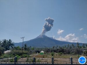
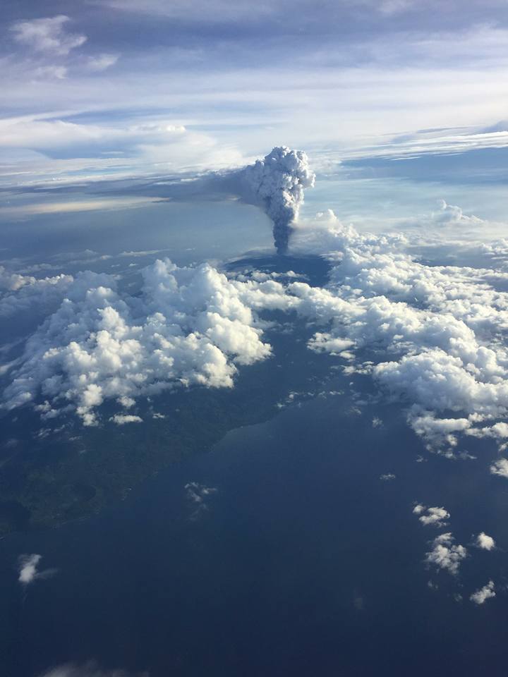
15.4°S, 167.83°E
Elevation 1496 m
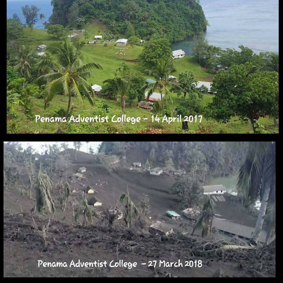
Based on satellite data, webcam observations, and wind model data, the Wellington VAAC reported that during 21-27 March ash plumes from the vent at Ambae’s Lake Voui rose to altitudes of 3-4.6 km (10,000-15,000 ft) a.s.l. and drifted mainly S and SW, but towards the end of the week to the N and W. News articles noted that ashfall had significantly impacted the S and W parts of the island, damaging crops, contaminating water, and collapsing homes, leading to the evacuation of three villages. On 25 March a flight was cancelled. Residents of Santo reportedly witnessed incandescent material being ejected as high as 1 km around 1800 and 2200; residents also noted four more events during the next morning that were also heard in Pentecost and Maewo.
Source : newsie.co.nz. , GVP.
Photo : Penama man
Mocho-Choshuenco , Chili :
Special Report on Volcanic Activity (REAV)
Los Rios area, Mocho-Choshuenco volcano, March 28, 2018, 09:00 local time (mainland Chile)
The National Geological and Mining Service of Chile (SERNAGEOMIN) describes the following preliminary information obtained by the monitoring teams of the National Volcano Monitoring Network (NVRN), processed and analyzed at the Volcanological Observatory of the South Andes (Ovdas):
Today, Wednesday, March 28, at 8:35 am local time (11:35 GMT), the monitoring stations installed on the Mocho-Choshuenco volcano recorded a seism of volcano-tectonic origin.
The characteristics of the earthquake after its analysis are as follows:
TIME OF ORIGIN: 08:35 local time (11:35 GMT)
LATITUDE: 39.928 ° S
LENGTH: 72.018 ° W
DEPTH: 3.6 km
LOCAL AMPLITUDE: 3.1 (ML)
COMMENTS.
At the time of this report, no associated replicas have been saved. It has not been reported as felt by the community.
The volcanic technical alert remains at:
Warning level GREEN
Sernageomin monitors online and informs on a timely basis of possible changes in the country’s volcanic activity.
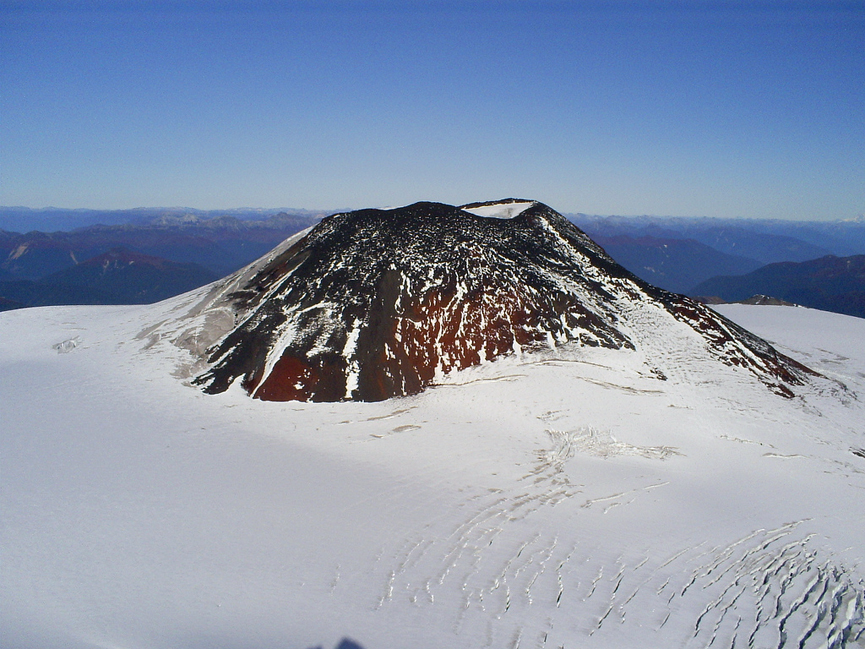
The compound Mocho-Choshuenco volcano is composed of twin glacier-covered stratovolcanoes, located east of Lago Rinihué and SE of Lago Panguipulli and post-dating a 4-km-wide basaltic caldera. The small Choshuenco stratovolcano, constructed on the NW rim of the caldera, is late-glacial in age. A major plinian eruption produced the Neltume Pumice about 10,300 years ago. The larger andesitic-to-dacitic, 2422-m-high El Mocho volcano, constructed within the caldera, is postglacial and has been historically active. Parasitic craters and basaltic scoria cones are located on the flanks of Mocho-Choshuenco, primarily on the NE and SW sides. Two historical eruptions have been reported, one in 1864 and the other in 1937.
Source : Sernageomin, GVP .
Photo : Reserve Naturelle.
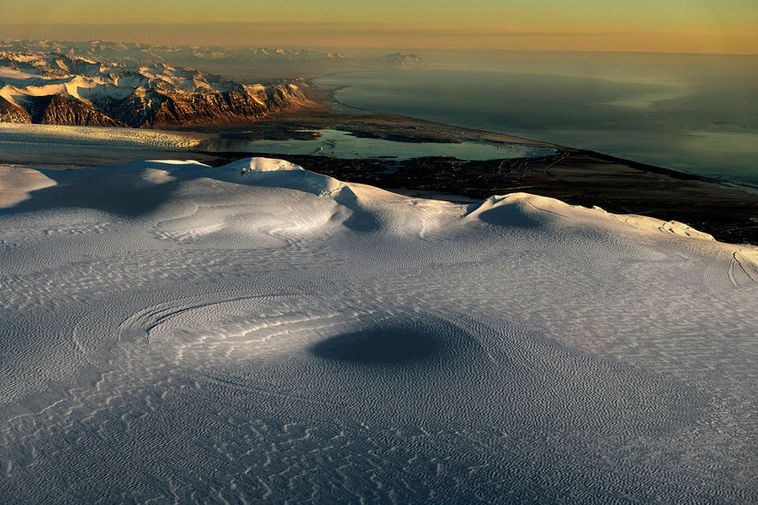
Öræfajökull, Iceland :
Seismic activity in Öræfajökull still going strong.
« Plenty of reason to monitor the course of events carefully. » mbl.is/RAX
Seismic activity in Öræfajökull volcano continues. This month, fourteen earthquakes measuring over 1.2 have been detected.
An uncertainty level was declared in October and has yet not been lifted. Seismic activity has increased steadily since autumn 2016 and in the past few months it’s been stronger than since measurements began four decades ago.
Geophysicist Páll Einarsson says in today’s issue of Morgunblaðið that these earthquakes « are telling us that there’s plenty of reason to monitor the course of events carefully. »
Source : Iceland Monitor.
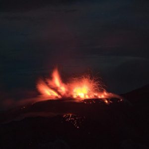
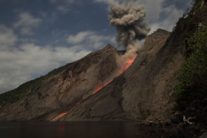
Shinmoedake , Kyushu , Japan :
31.934°N, 130.862°E
Elevation 1700 m
JMA reported that the eruption at Shinmoedake (Shinmoe peak), a stratovolcano of the Kirishimayama volcano group, continued during 19-27 March. Lava effusion possibly stopped on 9 March, though the lava flow on the NW flank continued to advance. A high number of volcanic earthquakes continued to be recorded, in addition to many low-frequency earthquakes with shallow hypocenters. Short-duration volcanic tremor was occasionally recorded.
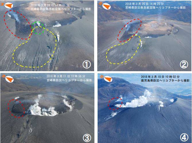
Kirishima Shinmoedake: Last JMA Activity Report, a new vent was observed at the edge of the west side of the crater: In green, the new vent, in yellow the traces of the PF and in red the overflow of the lava slab.
During a field survey on 22 March scientists measured 600 tons/day of sulfur dioxide gas, and noted that the crack on the W flank had grown slightly larger. On 25 March an explosion at 0735 was followed by an ash plume that rose 3.2 km above the crater rim and ejected material as far as 800 m. An event at 0845 generated an ash plume that rose 2.1 km above the crater rim, and a very small pyroclastic flow that traveled 800 m W. Sulfur dioxide emissions were 300 tons/day on 24 March. The Alert Level remained at 3 (on a scale of 1-5).
Source: Japan Meteorological Agency (JMA), GVP.
Mayon , Philippines :
MAYON VOLCANO BULLETIN , 29 March 2018 , 08:00 A.M.
This serves as a notice for the lowering of Mayon Volcano’s status from Alert Level 3 (decreased tendency towards hazardous eruption) to Alert Level 2 (moderate level of unrest).
Mayon’s volcano monitoring network and active observation of day-to-day conditions have recorded a general decline in unrest, as indicated by the following monitored parameters:
1. Volcanic Earthquake Activity: For the past two weeks, seismic activity has waned from a peak of eighty-two (82) to less than ten (10) rockfall events attributed to the collapse of unstable lava flow deposits on the Miisi, Bonga and Basud drainage systems. Low frequency earthquakes associated with magma degassing and short ash plumes were last recorded on 15 March 2018, although lava flow effusion from the crater could be detected until 18 March 2018. The overall decline in seismicity indicates that there is currently no active transport of eruptible magma to the shallow levels of the edifice.
2. Ground Deformation: Since 20 February 2018, medium-term deflation of Mayon’s edifice has been recorded by electronic tilt and Precise Leveling (PL) surveys despite short-term episodes of inflation of its lower and middle slopes. The downtrend in ground deformation follows a period of continuous inflation that began in October-November 2017 and implies that magma recharge from deep to shallower levels of the edifice has decreased. Based on medium-term PL data, nonetheless, the volcano is still inflated relative to January 2010 baselines, most likely due to the presence of remnant magma beneath the edifice.
3. Volcanic Degassing: Magmatic sulfur dioxide or SO2 flux measured for the past two weeks has fluctuated within the range of 500-2000 tonnes/day, which is lower than 700-4500 tonnes/day for the period of eruption from 13 January 2018 to 8 March 2018. The current concentrations of SO2 reflect the diminishing volumes of gas exsolved from unreplenished magma beneath the edifice as well as from cooling lava deposits on the summit and volcanic slopes.
4. Visual Parameters: Since the last observation of lava effusion on 18 March 2018, no new lava has been detected on Mayon’s summit crater. Crater glow, which is incandescence associated with superheated gas emission at the summit vent, has diminished from intense to faint. Gravity-driven lava flow has begun to stabilize, producing less rockfall and infrequent pyroclastic density currents, the last of which occurred on 27 March 2018. The decline in observable surface parameters is consistent with the cessation of magma supply to the shallow levels of the volcanic edifice.
In view thereof, PHIVOLCS-DOST is now lowering the alert status of Mayon from Alert Level 3 to Alert Level 2, signifying the cessation of eruptive activity and the decline to a moderate level of unrest. However, the lowering of the alert status should not be interpreted to mean that the volcano’s unrest has ceased, considering that the edifice is still inflated relative to its baseline level. If there is a resurgence of volcanic unrest based on any one or combination of the above monitoring parameters, the alert status may step up to Alert Level 3 again. On the other hand, if there is a noticeable return to baseline levels of ground deformation and sustained low levels of other parameters, then the Alert Level may further step down. The public is still reminded to avoid entry into the 6-km Permanent Danger Zone or PDZ due to perennial hazards of rockfalls, avalanche, ash puffs and sudden steam-driven or phreatic eruptions at the summit area. Furthermore, people living in valleys and active river channels are cautioned to remain vigilant against sediment-laden streamflows and lahars in the event of prolonged and heavy rainfall. PHIVOLCS-DOST is closely monitoring Mayon Volcano’s activity and any new development will be immediately posted to all concerned.
Source : Phivolcs.