February 10 , 2024.
Iceland , Reykjanes Peninsula :
Updated 9. February at 13:00 UTC
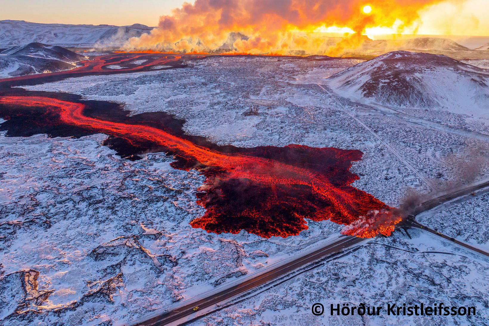
Volcanic tremor has significantly decreased since yesterday (8th of February). The decrease was detected shortly after noon yesterday alongside decreased eruptive activity on the volcanic fissure and activity became more confined in separate craters. Temporary increases of the volcanic tremor were noted last evening, which coincided with increased volcanic activity in the craters. During the night, the activity decreased further and between 7 and 8 this morning, two eruptive craters were active. For the past hours no lava fountaining has been observed on web-cameras but activity within the craters might still be ongoing.
Satellite radar image taken at 14:56 yesterday shows surface subsidence of 10 cm in Svartsengi area, north-west of mt. Þorbjörn, when magma flowed from there towards Sundhnúkur crater row. Model calculations based on these data suggest that about 10 million m3 of magma has flowed from the magma reservoir beneath Svartsengi towards the eruption site at Sundhnúkur crater row.
Seismic activity at the eruptive site has been minor during the past 24 hours. About 40 earthquakes have been detected there, all around or smaller than M1.
Volume estimates of the erupted lava from the start of the eruption at 6:02 until 13:00 yesterday (8th of February) is about 15 million m3, which corresponds to an average extrusion rate of 600 m3/s during the first seven hours (data provided by Icelandic Institute of Natural History and Landmælingar Íslands).
Although the eruption has significantly decreased it is still too early to declare if it has come to an end. IMO maintains a 24-hour watch and keeps a close eye on the area. An updated hazard assessment will be published later today.
No signs of eruptive activity. Updated hazard assessment according to the development
Updated 9. February at 15:30 UTC
No eruptive activity was observed in a drone-flight over the eruptive site carried out at noon today (9 February) by the Special Unit of the National Police Commissioner. This suggests that the eruption is ending. Volcanic tremor is no longer being detected on seismic sensors.
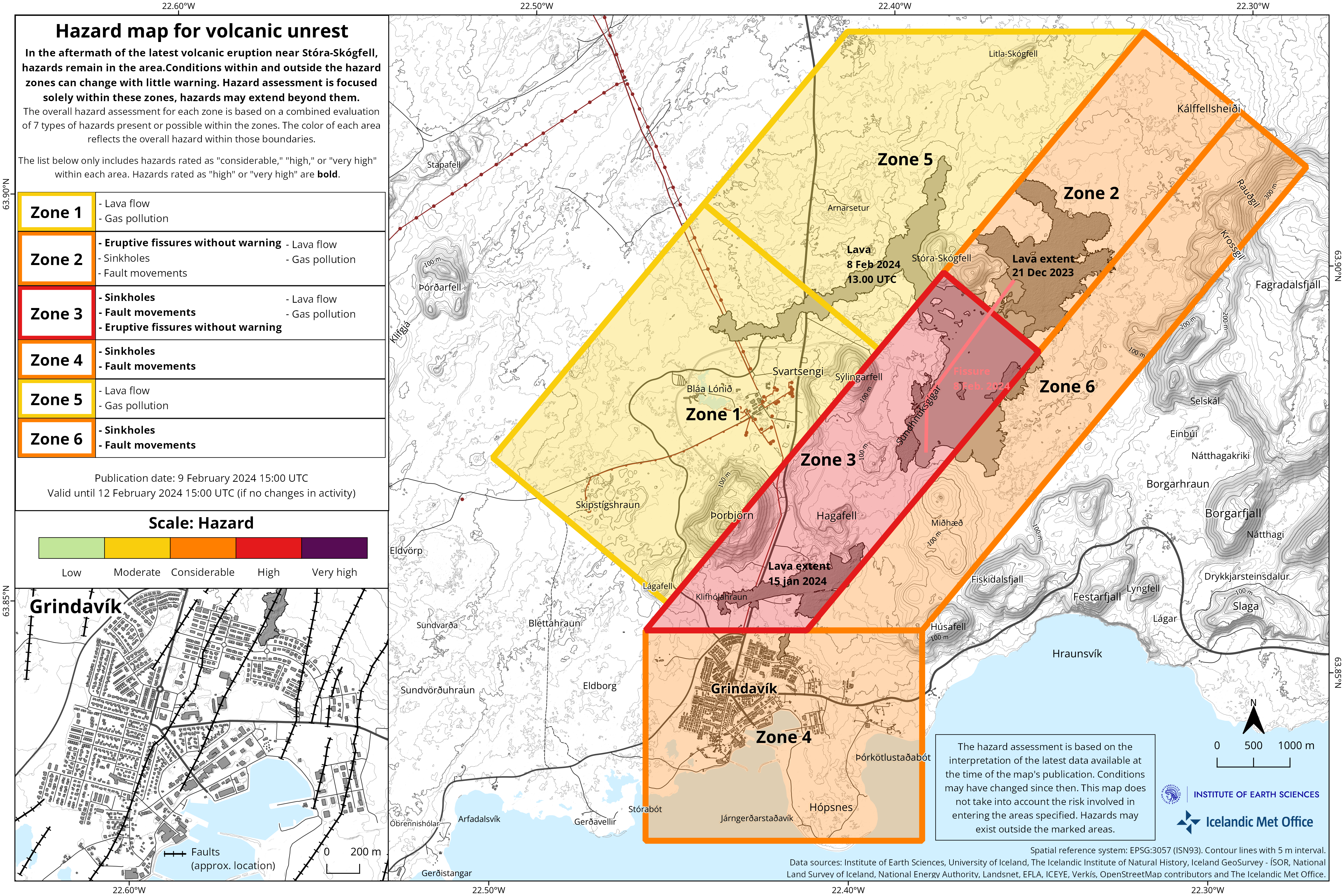
IMO has updated the hazard assessment according to the development of the eruptive activity. Changes have been made to the hazard assessment for some hazards within zones. Hazards due to opening of volcanic fissures has decreased, but hazards due to gas pollution are still considered to be likely by the lava flow front. Hazards due to lava flow is still in place, as lava lobes can burst out from the lava flow front. Hazards due to sinkholes and fault movements are still considered high in Zone 4 (Grindavík).
Source : IMO
Photo : Hörður Kristleifsson
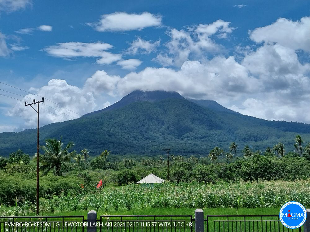
Indonesia , Lewotobi Laki Laki :
An eruption of Mount Lewotobi Laki occurred on Friday, February 9, 2024, at 6:58 p.m. WITA. The height of the eruptive column was observed to be ±500 m above the peak (±2084 m above sea level). The ash column was white to gray in color with moderate to thick intensity, oriented towards the North and Northeast. At the time of writing, the eruption was still ongoing.
SEISMICITY OBSERVATIONS:
13 avalanche earthquakes with an amplitude of 2.9 to 22.2 mm and a duration of 22 to 116 seconds.
6 low-frequency earthquakes with an amplitude of 2.9 to 14 mm and an earthquake duration of 10 to 34 seconds.
3 hybrid/multi-phase earthquakes with an amplitude of 5.1 to 10.5 mm, with an earthquake duration of 8 to 13 seconds.
1 Deep volcanic earthquake with an amplitude of 23.6 mm, and an earthquake duration of 13 seconds.
1 Distant tectonic earthquake with an amplitude of 10.5 mm, and the earthquake lasted 228 seconds.
Recommendation
1. Communities around Mount Lewotobi Laki and visitors/tourists do not carry out any activities within a radius of 4 km around the center of the eruption of Mount Lewotobi Laki and within a sector of 5 km in the North-North direction. East and 6 km in the direction of the North – East sector.
2. The public should remain calm and follow the instructions of the regional government and not believe rumors whose origin is unclear.
Source et photo : Magma Indonésie
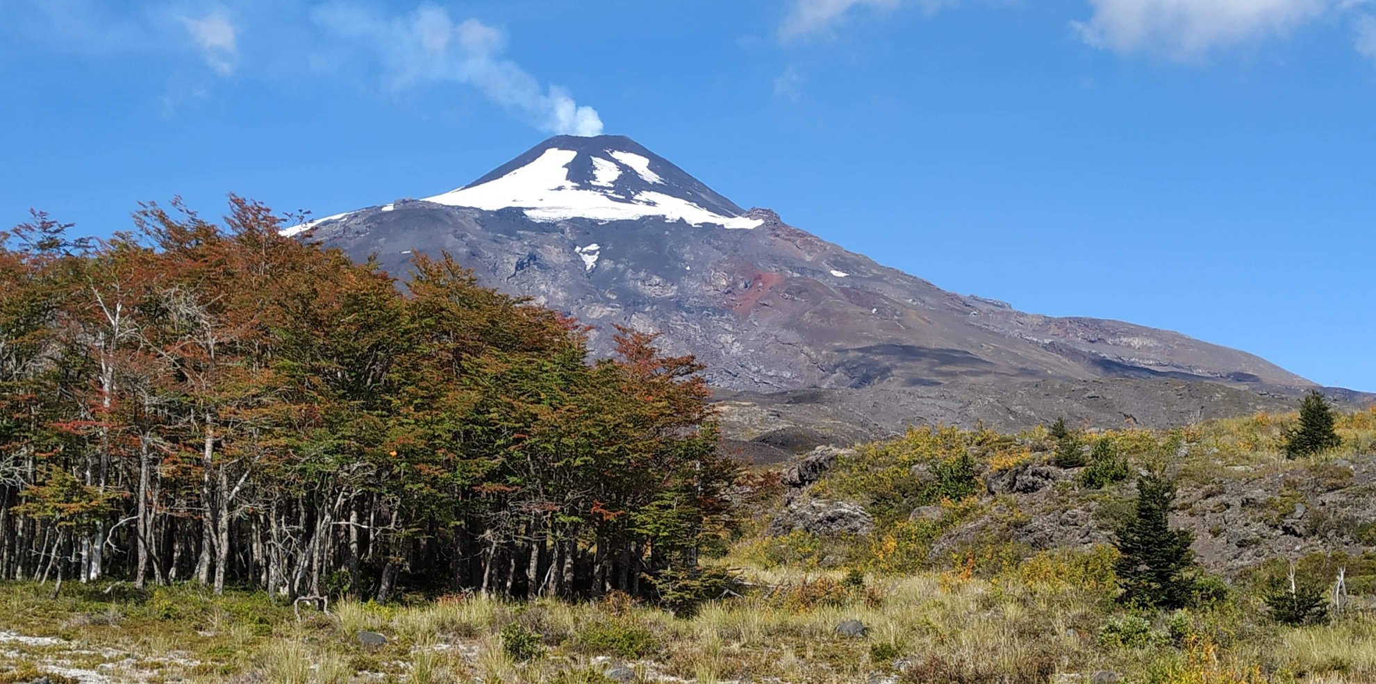
Chile , Villarica :
Special Report on Volcanic Activity (REAV), La Araucanía and Los Ríos regions, Villarrica volcano, February 10, 2024, 02:40 local time (mainland Chile)
The National Geology and Mining Service of Chile (Sernageomin) announces the following PRELIMINARY information, obtained through the monitoring equipment of the National Volcanic Monitoring Network (RNVV), processed and analyzed at the Southern Andean Volcano Observatory (Ovdas):
On Saturday February 10, 2024, at 02:24 local time (05:24 UTC), monitoring stations installed near the Villarrica volcano recorded an earthquake associated with the fracturing of rocks inside the volcanic system (volcano-tectonic type).
The characteristics of this earthquake after its analysis are as follows:
ORIGINAL TIME: 02:24 local time (05:24 UTC)
LATITUDE: 39.436°S
LONGITUDE: 71.873°E
DEPTH: 6.9 km
LOCAL MAGNITUDE: 3.5 (ML)
Observation :
After the event mentioned in this report, other earthquakes of lower magnitude continue to be recorded. This seismicity is not directly correlated with an increase in surface activity.
The technical volcanic alert is maintained at YELLOW level.
Source : Sernageomin.
Photo : Yv’an roue libre.
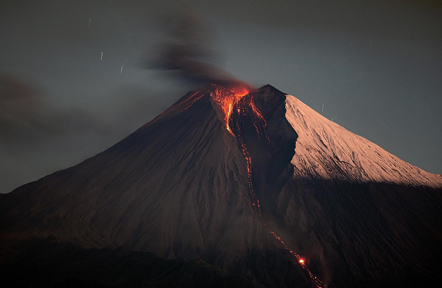
Ecuador , Sangay :
DAILY REPORT ON THE STATE OF THE SANGAY VOLCANO, Friday February 9, 2024.
Information Geophysical Institute – EPN.
Surface activity level: High, Surface trend: Descending
Internal activity level: High, Internal trend: No change
Seismicity: From February 8, 2024, 11:00 a.m. to February 9, 2024, 11:00 a.m.:
The number of seismic events recorded at the reference station over the past 24 hours is shown below. The level of seismic activity of the volcano remains high.
Explosion Event (EXP): 132
Precipitation/Lahars:
No rain was recorded in the volcano area which could generate mud and debris flows.
Emissions/ash column:
Due to the climatic conditions of the area, it was not possible to record gas or ash emissions via the surveillance camera system or the GOES-16 satellite.
Other monitoring parameters:
The FIRMS and MIROVA-VIIRS satellite systems recorded 10 and 1 thermal anomalies respectively over the last 24 hours.
Observation:
Since yesterday afternoon until the time of this report, the volcano has remained completely cloudy. Despite the conditions of the area, episodes of incandescence were recorded with material falling into the southeast ravine up to 1,000 meters below the level of the crater.
Alert level: yellow
Source : IGEPN.
Photo : Eqphos_fotografía
Hawaii , Pāhala :
HAWAIIAN VOLCANO OBSERVATORY INFORMATION STATEMENT
U.S. Geological Survey
Friday, February 9, 2024, 11:04 AM HST (Friday, February 9, 2024, 21:04 UTC)
On Friday, February 9, 10:06 a.m. HST, a magnitude-5.7 earthquake occurred 2 km (1.25 mi) southwest of Pāhala on the Island of Hawaiʻi at a depth of 37 km (23 mi) below sea level. The earthquake had no apparent impact on either Mauna Loa or Kīlauea volcanoes. Numerous aftershocks have been felt and are expected to continue. This earthquake is likely associated with lithospheric flexure caused by the weight of the Hawaiian Islands on the oceanic lithosphere. The USGS Hawaiian Volcano Observatory continues to monitor Hawaiian volcanoes for any changes.
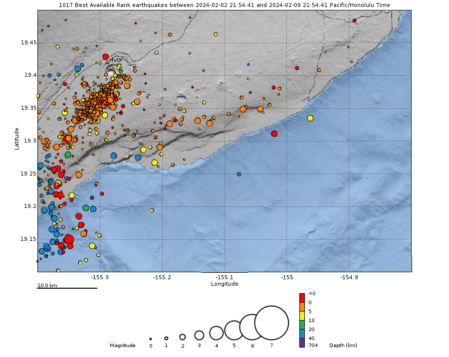
EARTHQUAKE DESCRIPTION
Magnitude: 5.7
Date and Time: February 9, 2024, at 10:06 a.m. HST
Location: 1.25 mi (2 km) SE of Pāhala
Depth: 23 mi (37 km) below sea level
Aftershocks are possible in the coming days to weeks
EARTHQUAKE INTENSITY AND AFFECTED AREA
Potential Damage: No damage to buildings or infrastructure expected based on earthquake intensity
Maximum Intensity, Modified Mercalli Scale (https://www.usgs.gov/natural-hazards/earthquake-hazards/science/modifie…)
Community-reported: VI – strong shaking
Instrument-derived: VII – very strong shaking
Felt Reports: More than 280 within the first hour
Felt Area: Widely felt across the islands of Hawaiʻi and Maui, and parts of O‘ahu
Source et photo : HVO