February 08 , 2024.
Iceland , Reykjanes Peninsula :
Apparemment , une éruption à commencé en Islande .
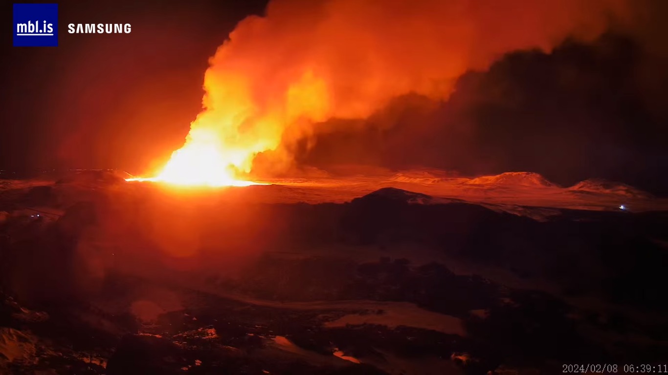
“According to initial reports from the Coast Guard surveillance flight, the eruption took place in the same area as that of December 18. The crack is approximately three kilometers long,” adds the IMO. The institute predicted an imminent eruption in its latest report.
Source : MBL IS , via Michal Geryk / FB. Le Parisien.
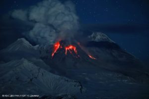
Philippines , Mayon :
PHIVOLCS reported that unrest continued at Mayon during 31 January-6 February. Crater incandescence was visible daily. The seismic network recorded a few volcanic earthquakes and rockfall signals during the week. A phreatic explosion was recorded by the seismic network at 1647 on 4 February and lasted for two minutes and 49 seconds. The explosion produced an ash-and-steam plume that rose 1.2 km above the summit and drifted SW, ejected blocks onto the flanks, and generated pyroclastic density currents that descended the flanks. Booming noises were reported by residents. The Alert Level remained at 2 (on a 0-5 scale). Residents were reminded to stay away from the 6-km-radius Permanent Danger Zone (PDZ) and pilots were advised to avoid flying close to the summit.
SETTINGS
Eruption: 1 phreatic eruption (duration 169 seconds)
Seismicity: 0 volcanic earthquake
Sulfur dioxide flow: 621 tonnes / day (February 2, 2024)
Plume: Moderate emission; northwest drift
Ground deformation: Short-term inflation of the building
Sources : GVP , Phivolcs.
Photo : Gulfnews.
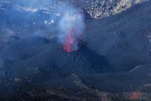
Japan , Suwanosejima :
JMA reported that the eruption at Suwanosejima’s Ontake Crater continued during 29 January-5 February. Crater incandescence was observed in webcam images nightly and rumbling was occasionally heard in Toshima village (3.5 km SSW). A total of three explosions were recorded during the week, ejecting large blocks as far as 300 m from the vent. The first explosion, at 1135 on 29 January, produced an ash plume that rose 1 km above the crater rim and drifted SE. The second explosion was recorded at 0950 on 31 January, though details about emissions were unknown. The third explosion, at 2223 on 31 January, generated an ash plume that rose 500 m and drifted E. The Alert Level remained at 2 (on a 5-level scale) and the public was warned to stay at least 1 km away from the crater.
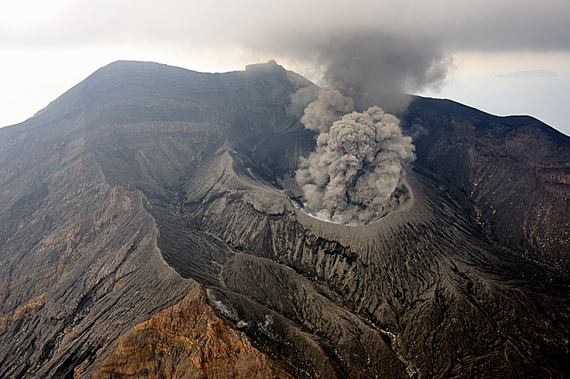
The 8-km-long island of Suwanosejima in the northern Ryukyu Islands consists of an andesitic stratovolcano with two historically active summit craters. The summit is truncated by a large breached crater extending to the sea on the east flank that was formed by edifice collapse. One of Japan’s most frequently active volcanoes, it was in a state of intermittent Strombolian activity from Otake, the NE summit crater, between 1949 and 1996, after which periods of inactivity lengthened. The largest recorded eruption took place in 1813-14, when thick scoria deposits blanketed residential areas, and the SW crater produced two lava flows that reached the western coast. At the end of the eruption the summit of Otake collapsed, forming a large debris avalanche and creating the open Sakuchi caldera, which extends to the eastern coast. The island remained uninhabited for about 70 years after the 1813-1814 eruption. Lava flows reached the eastern coast of the island in 1884. Only about 50 people live on the island.
Sources : Agence météorologique japonaise (JMA) , GVP.
Photo : N. Geshi. Geological Survey of Japan, H.Seo
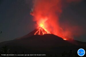
Indonesia , Ibu :
Mount Ibu exhibited an eruption on Thursday, February 8, 2024 at 1:41 p.m. WIT with the height of the ash column observed at ±1000 m above the summit (±2325 m above sea level). The ash column was observed to be gray with thick intensity, oriented towards the East. This eruption was recorded on a seismograph with a maximum amplitude of 28 mm and a duration of 88 seconds.
SEISMICITY OBSERVATIONS
28 eruption/explosion earthquakes with an amplitude of 15 to 28 mm and a duration of 25 to 85 seconds.
107 emission earthquakes with an amplitude of 2 to 14 mm and earthquake duration of 10 to 45 seconds.
138 Shallow volcanic earthquakes with an amplitude of 2 to 14 mm and an earthquake duration of 6 to 12 seconds.
7 deep tectonic earthquakes with an amplitude of 2 to 16 mm, and duration of the earthquake 55 to 95 seconds.
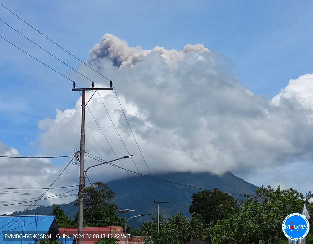
PVMBG reported that Ibu continued to erupt during 17-23 January. White-and-gray ash emissions rose 200-1,500 m above the summit and drifted in multiple directions. An eruptive event at 2200 on 2 February produced a white, gray, and black ash plume that rose as high as 2 km above the summit and drifted mainly SW. Booming noises were heard at the observation post. According to a news article, incandescent material was ejected 600 m above the summit and as far as 1 km to the N, NW, W, and S. The Alert Level remained at 2 (the second highest level on a four-level scale), with the public advised to stay outside of the 2 km hazard zone and 3.5 km away from the N area of the active crater.
Sources : Pusat Vulkanologi et Mitigasi Bencana Geologi (PVMBG, également connu sous le nom de CVGHM), Antara News , GVP.
Photo : Magma Indonésie.
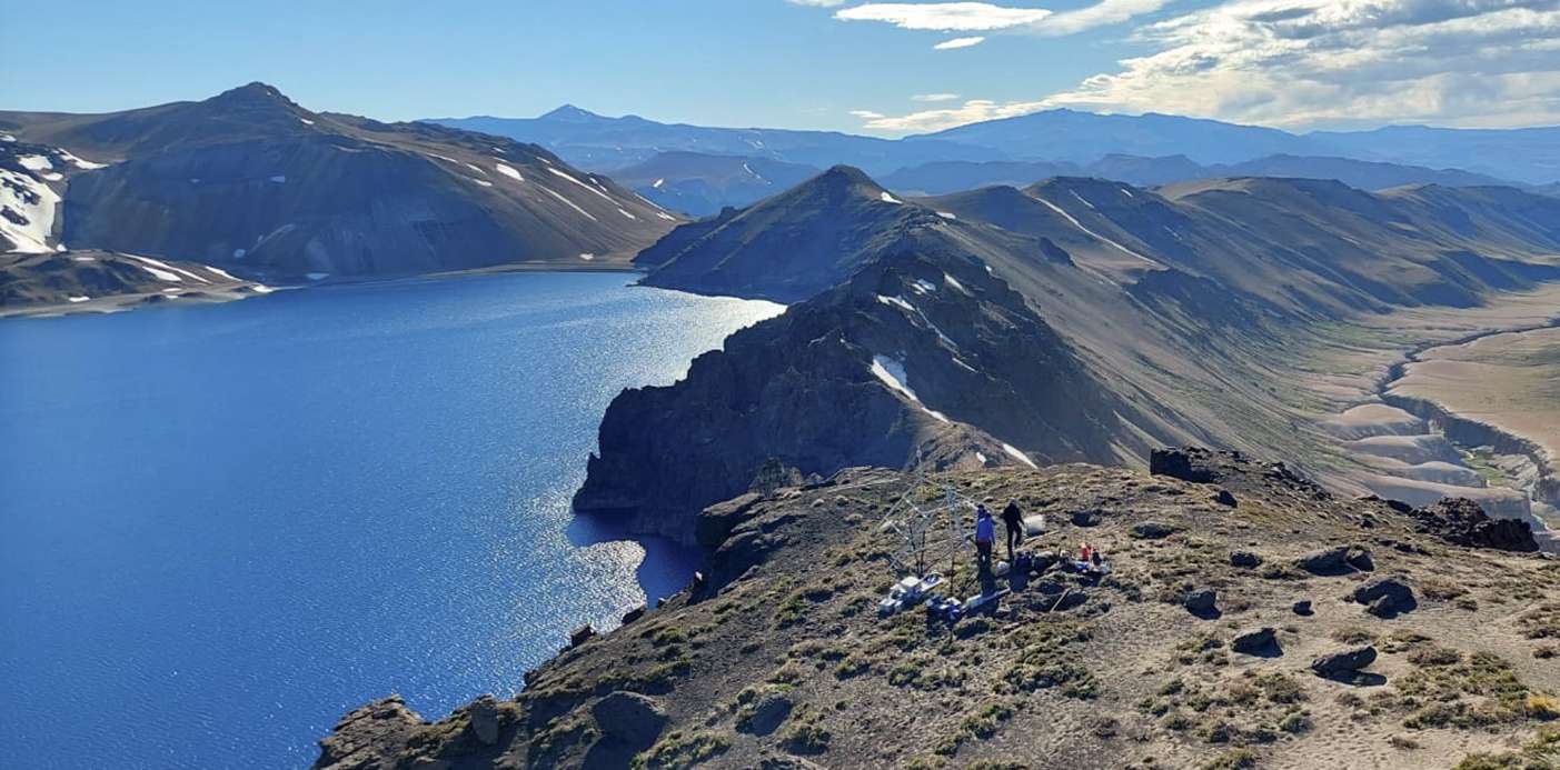
Chile , Laguna del Maule :
Special Report on Volcanic Activity (REAV), Maule region, Laguna del Maule volcanic complex, February 7, 2024, 5:50 p.m. local time (mainland Chile)
The National Geology and Mining Service of Chile (Sernageomin) announces the following PRELIMINARY information, obtained through the monitoring equipment of the National Volcanic Monitoring Network (RNVV), processed and analyzed at the Andes del Sud Volcanological Observatory ( Ovdas):
On Wednesday February 7, 2024 at 5:40 p.m. local time (8:40 p.m. UTC), monitoring stations installed near the Laguna del Maule volcanic complex recorded an earthquake associated with rock fracturing (volcano-tectonic type, VT).
The characteristics of the largest magnitude earthquake recorded so far after its analysis are as follows:
ORIGINAL TIME: 5:40 p.m. local time (8:40 p.m. UTC)
LATITUDE: 36.074°S
LONGUITUDE: 70.465°W
DEPTH: 7.6 km
LOCAL MAGNITUDE: 3.8 (ML)
Comments:
Following the event described, no increase in seismicity was recorded.
The technical volcanic alert remains at the Yellow level.
Source : Sernageomin.
Photo : neuqueninforma.gob.ar
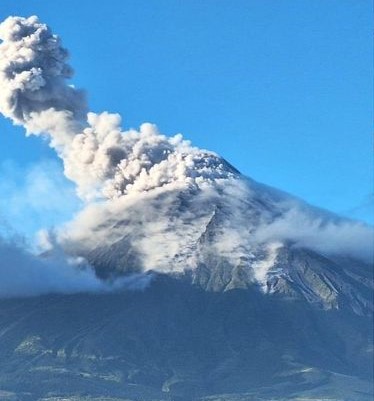
Colombia , Nevado del Ruiz :
Weekly bulletin on the activity of the Nevado del Ruiz volcano
From the monitoring of the activity of the NEVADO DEL RUIZ VOLCANO, the MINISTRY OF MINES AND ENERGY through the COLOMBIAN GEOLOGICAL SERVICE (SGC) reports that:
In the week from January 30 to February 6, 2024, the volcano continued with unstable behavior. Compared to the previous week, the main variations in the parameters monitored were:
– Seismicity associated with fluid dynamics within volcanic conduits showed similar levels in the number of earthquakes recorded and an increase in seismic energy released. The seismic signals were mainly related to pulsatile emissions of ash and gas into the atmosphere and showed low to moderate energy levels. In particular, the duration of some signals of this type was longer than that recorded the previous week. Thanks to cameras used to monitor the volcano and reports from SGC staff or Los Nevados National Natural Park officials, several ash emissions associated with some of these seismic signals have formed. Thermal cameras (FLIR) also captured several changes in the relative temperature of emitted materials related to them.
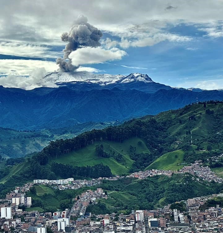
– Seismic activity associated with the fracturing of rocks within the volcanic edifice has maintained similar levels in the number of earthquakes recorded and in the seismic energy released. The earthquakes were located mainly in the Arenas crater and on the northeast, southeast and south-southwest flanks of the volcano, up to approximately 5 km from the crater. The depths of the events varied between less than 1 and 7 km from the volcano summit. The highest magnitude of the week was 1.1, corresponding to the earthquake of February 2 at 6:48 a.m., located approximately 2 km south-southeast of the crater, at 4 km depth. The recording of seismicity linked to the activity of the lava dome (protuberance or mound) located at the bottom of the crater continued. This seismicity had low energy levels and was generally short-lived.
Sulfur dioxide (SO2) outgassing rates were variable and continued at low values. The decreasing trend in this parameter is not only due to volcanic activity but also to the weather conditions of the week (low wind speeds, variable wind direction and cloud cover). The maximum height of the gas or ash column (vertically and dispersed) was 1800 m measured above the summit of the volcano on February 5, associated with the emission of ash at 09:53. The direction of column dispersion was variable and was observed vertically on many occasions. The column of gas and water vapor observed on the afternoon of Sunday February 4 is distinguished by its density and its orange hues caused by solar reflection during sunset.
– When monitoring thermal anomalies at the bottom of Arenas Crater from satellite monitoring platforms, anomalies of moderate energy levels persist.
Source : SGC
Photo : Alex Jimenez Matiz