January 24 , 2024.
Iceland , Grímsvötn :
Conclusion of Grímsvötn Glacial Outburst Flood . Ice cauldron formed south of Grímsfjall
Updated 23 January at 9:00 UTC
Since the glacial flood reached its peak in the river Gígjukvísl approximately a week ago, the water level has been decreasing and is now comparable to what it was before the flood. The seismic tremor measured on the seismometer at Grímsfjall has also declined, with seismic noise now back to normal levels. Since last week Monday, 21 earthquakes have been recorded in Grímsvötn, including two earthquakes exceeding magnitude two.
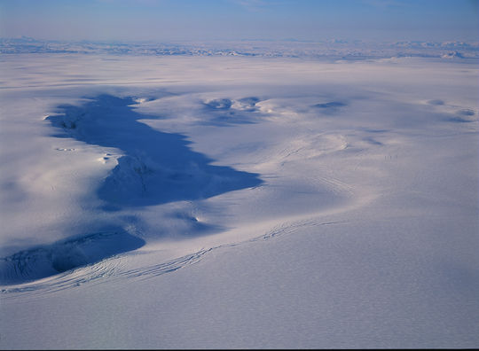
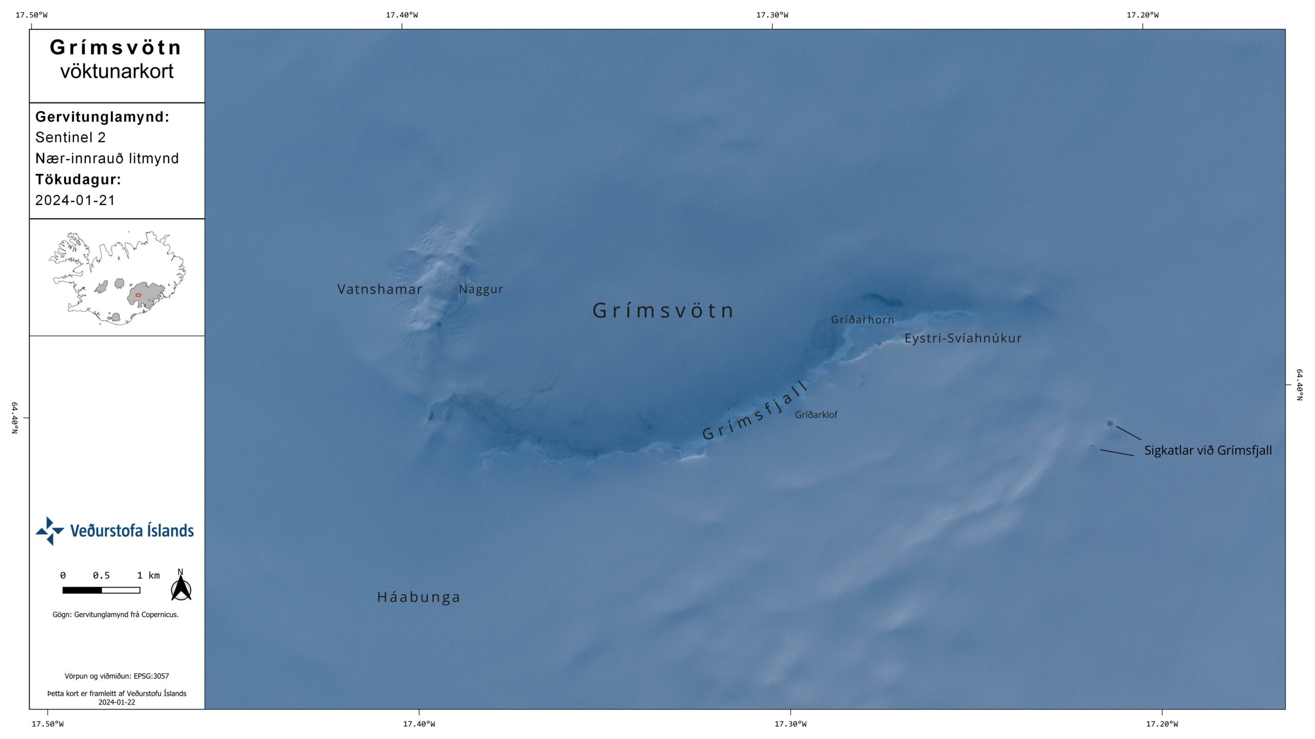
During the glacial flood from Grímsvötn in 2021, an ice cauldron (GV-33), which is crevassed depression on the glacier surface, formed south of Grímsfjall. The cauldron is located near the flood path, where water drains beneath the glacier. Staff of the Icelandic Meteorological Office, who were on a trip to conduct measurements at Vatnajökull last week, identified a depression similar to the 2021 ice cauldron in the same location. Upon closer examination of satellite images from yesterday, January 21, two cauldrons south of Grímsfjall can be observed. One of them is confirmed to be the cauldron that formed in the 2021 flood, but the other may either be a new cauldron that formed during the recent flood or an older cauldron that has re-emerged. The ice cauldrons are near the route east of Grímsfjall, and it is advisable to avoid the cauldrons when traveling along those routes.
The coordinates for the cauldrons’ locations are as follows:
Cauldron GV-33: 64°23.611′, -17°13.017′ (decimal degrees, WGS-84)
New cauldron: 64°23.766′, -17°12.729′ (decimal degrees, WGS-84)
When the recent glacial flood began, the aviation color code for Grímsvötn volcano was elevated to yellow, signifying the heightened potential for an eruption following pressure changes in the system after water drained from the subglacial lake. Now that the glacial flood is over and that there have been no significant changes in short-term seismic activity, the aviation color code will return to green.
Long-term monitoring of seismic activity at Grímsvötn reveals that, in the last five months, the number of earthquakes has been higher than the typical background seismicity. If an eruption were to occur in Grímsvötn, an increase in seismic activity may be expected before the eruption begins, but warning times may be short. Scientists from the Icelandic Meteorological Office and the Institute of Earth Sciences will continue to closely monitor Grímsvötn and provide information if activity increases further.
Source : IMO
Photos : Veðurstofa Íslands/Oddur Sigurðsson , IMO.
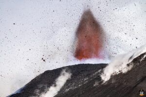
Italy / Sicily , Etna :
WEEKLY BULLETIN, from January 15, 2024 to January 21, 2024 (publication date January 23, 2024)
SUMMARY STATEMENT OF ACTIVITY
In light of the monitoring data, it appears:
1) VOLCANOLOGICAL OBSERVATIONS: Degassing activity at the Bocca Nuova Crater (BN) and the South-East Crater (CSE).
2) SEISMOLOGY: Low seismic activity due to fracturing. Average amplitude of the volcanic tremor at mid-level.
3) INFRASOUND: Low level infrasound activity. Sources located at the Bocca Nuova crater.
4) GROUND DEFORMATIONS: Over the past week, ground deformation monitoring networks have not recorded any significant changes.
5) GEOCHEMISTRY: SO2 flux at medium level
The CO2 fluxes emitted by the ground are at average values.
The partial pressure of CO2 dissolved in groundwater presents values included in seasonal variability.
The helium isotopic ratio is high.
6) SATELLITE OBSERVATIONS: Thermal activity observed by satellite was generally weak.

VOLCANOLOGICAL OBSERVATIONS
The monitoring of Etna’s volcanic activity during the week in question was carried out through the analysis of images from the INGV surveillance camera network, Osservatorio Etneo (INGV-OE). Observations were severely limited due to unfavorable climatic conditions.
Activity at the summit craters showed no change from what was observed the previous week, continuing with degassing activity mainly supported by Bocca Nuova (BN) and Southeast Crater (CSE ).
Source : INGV
Photo : Giuseppe Distefano
Indonesia , Semeru :
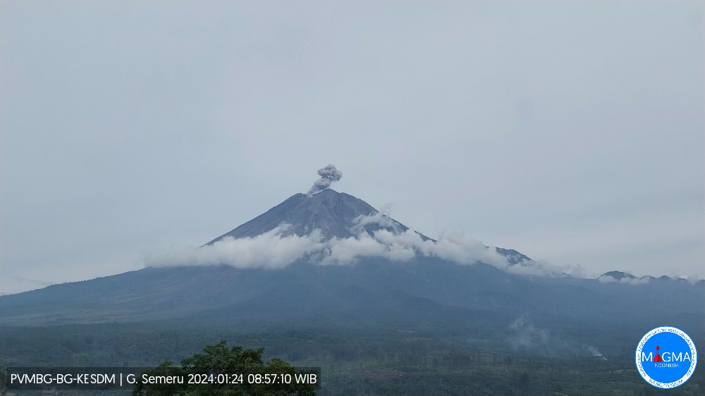
Mount Semeru erupted on Wednesday, January 24, 2024 at 08:55 WIB. The height of the eruptive column was observed to be ± 800 m above the peak (± 4,476 m above sea level). The ash column was observed to be gray with thick intensity, oriented towards the North and Northwest. The eruption was recorded on a seismograph with a maximum amplitude of 23 mm and a duration of 110 seconds.
VOLCANO OBSERVATORY NOTICE FOR AVIATION – VONA
Issued : January 24 , 2024
Volcano : Semeru (263300)
Current Aviation Colour Code : ORANGE
Previous Aviation Colour Code : orange
Source : Semeru Volcano Observatory
Notice Number : 2024SMR043
Volcano Location : S 08 deg 06 min 29 sec E 112 deg 55 min 12 sec
Area : East java, Indonesia
Summit Elevation : 11763 FT (3676 M)
Volcanic Activity Summary :
Eruption with volcanic ash cloud at 01h55 UTC (08h55 local).
Volcanic Cloud Height :
Best estimate of ash-cloud top is around 14323 FT (4476 M) above sea level or 2560 FT (800 M) above summit. May be higher than what can be observed clearly. Source of height data: ground observer.
Other Volcanic Cloud Information :
Ash cloud moving from north to northwest. Volcanic ash is observed to be gray. The intensity of volcanic ash is observed to be thick.
Remarks :
Eruption recorded on seismogram with maximum amplitude 23 mm and maximum duration 110 second.
Source : Magma Indonésie.
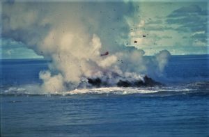
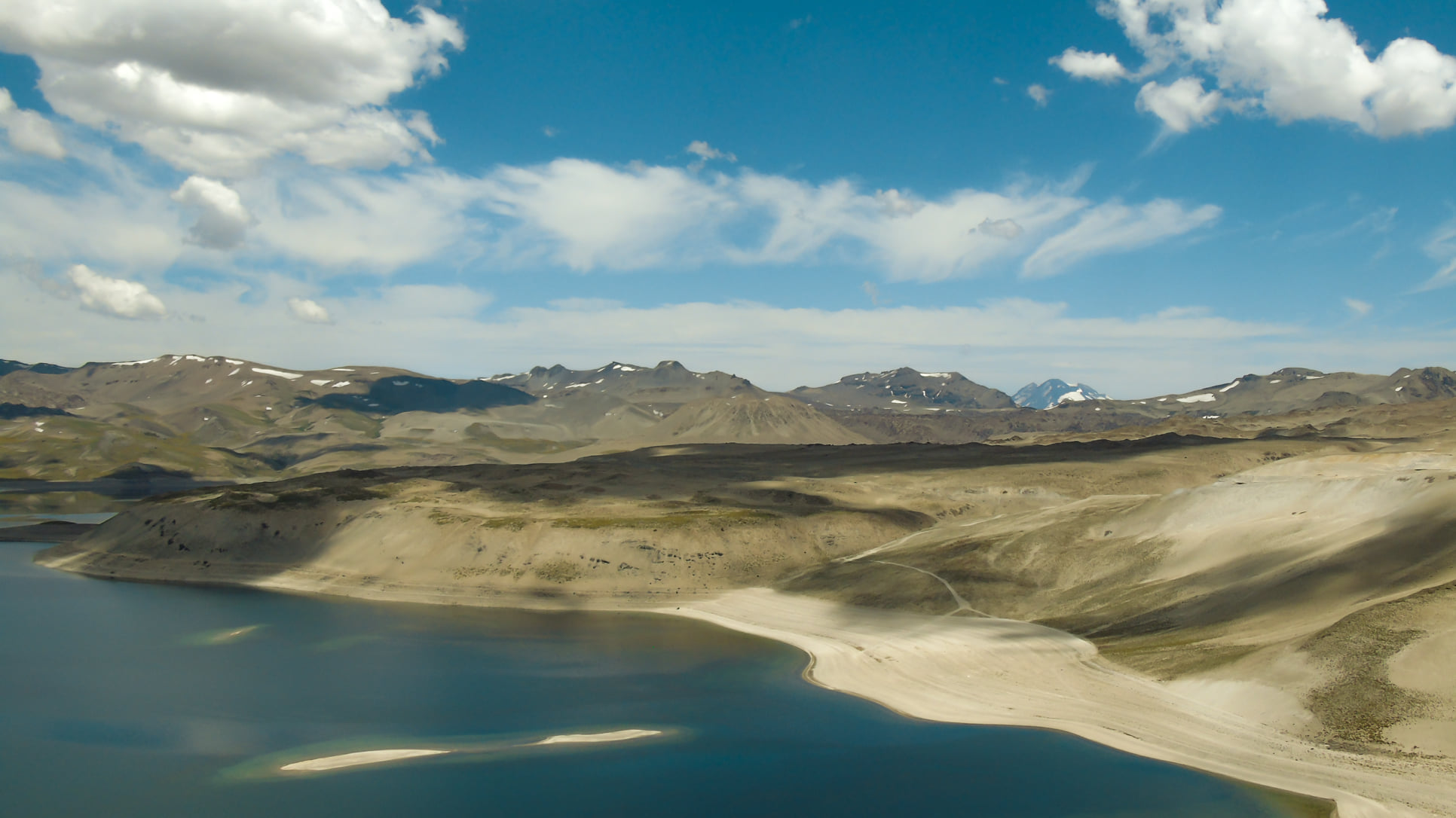
Chile , Laguna del Maule :
Seismology
The seismological activity of the period was characterized by the recording of:
1980 VT type seismic events, associated with the fracturing of rocks (Volcano-Tectonics). The most energetic earthquake had a Local Magnitude (ML) value equal to 3.2, located 7.5 km to the South-South -East of the center of the lagoon, at a depth of 7.1 km compared to the average height of the lagoon.
3 LP type seismic events, associated with fluid dynamics inside the volcanic system (Long Period). The size of the largest earthquake evaluated from the Reduced Displacement (RD) parameter was equal to 3 cm2.
1 TR type seismic event, associated with the dynamics maintained over time of fluids inside the volcanic system (TRemor). The size of the earthquake evaluated from the Reduced Displacement (RD) parameter was equal to 1.4 cm2.
Geodesy
From the 4 GNSS stations operating in the volcanic complex, we observe that the inflationary process continues. The maximum vertical deformation rate measured for this period is 0.8 cm/month, measured at the station located to the North-West of the lagoon and its maximum horizontal deformation rate is 0.93 cm/month in the North direction. -West. On the other hand, it is possible to observe thanks to radar interferometry data that the rise of the central zone of the lagoon continues at average rates close to 23 cm/year.
The appearance of recurrent VT type activity persists and with a slight tendency to increase its energies. During the period evaluated, certain events with ML> 3 were recorded which justified the issuance of a REAV bulletin, as well as a seismic swarm, located in the South-East sector of the lagoon. Deformation rates continue with values similar to those historically recorded. The above indicates a volcanic system with signs of magmatic activity that results in surface seismic activity and volcanic deformation. As a result, the technical alert remains yellow and its possible impact radius is 2 km measured from the CO2 anomaly zone.
YELLOW TECHNICAL ALERT: Changes in the behavior of volcanic activity
Source : Sernageomin
Photo : Franco Vera.
Colombia , Purace – Los Coconucos Volcanic Range :
Weekly bulletin of the activity of the Puracé volcano – Los Coconucos volcanic chain
From the monitoring of the activity of the VOLCANIC CHAIN PURACE VOLCANO – LOS COCONUCOS, the MINISTRY OF MINES AND ENERGY, through the COLOMBIAN GEOLOGICAL SERVICE (SGC), reports that:
During the week of January 16 to 22, 2024, seismic activity decreased in number of earthquakes and seismic energy released compared to the previous week. The fracture earthquakes were mainly located less than 3 km deep between the Puracé and Piocollo volcanoes, with low magnitudes; while those associated with fluids were mainly located less than 1 km on the western flank of the Puracé volcano, with very low magnitudes.
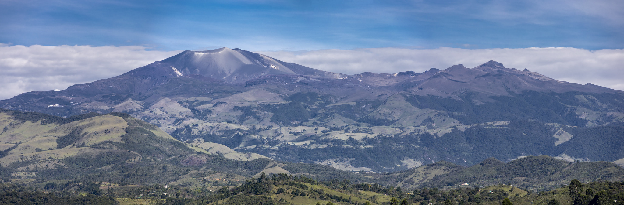
Likewise, localized deformations continued to be recorded between the Puracé and Curiquinga volcanoes. Carbon dioxide (CO2) values have decreased compared to those previously recorded; However, they remain higher than the reference values in this volcano. On the other hand, stable values were recorded in the sulfur dioxide (SO2) flux.
The images obtained using the installed cameras show that high degassing of the volcanic system is maintained, both inside the crater and in the external lateral fumarole.
(Northwest flank of the volcanic edifice).
The other parameters measured and used for the diagnosis of volcanic activity showed no notable changes during the period evaluated.
The alert status for volcanic activity remains at: YELLOW ALERT: ACTIVE VOLCANO WITH CHANGES IN THE BEHAVIOR OF THE BASE LEVEL OF MONITORED PARAMETERS AND OTHER MANIFESTATIONS.
Source : SGC
Photo : José María Arboleda C