January 16 , 2024.
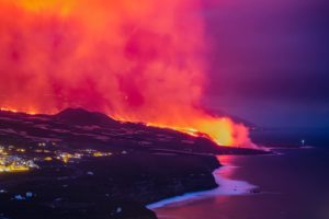
Iceland , Reykjanes Peninsula :
The intensity of the eruption decreases . New fissures may emerge on the surface of Grindavík in the coming days. The hazard assessment map has been updated . Updated 15 January at 16:40 UTC
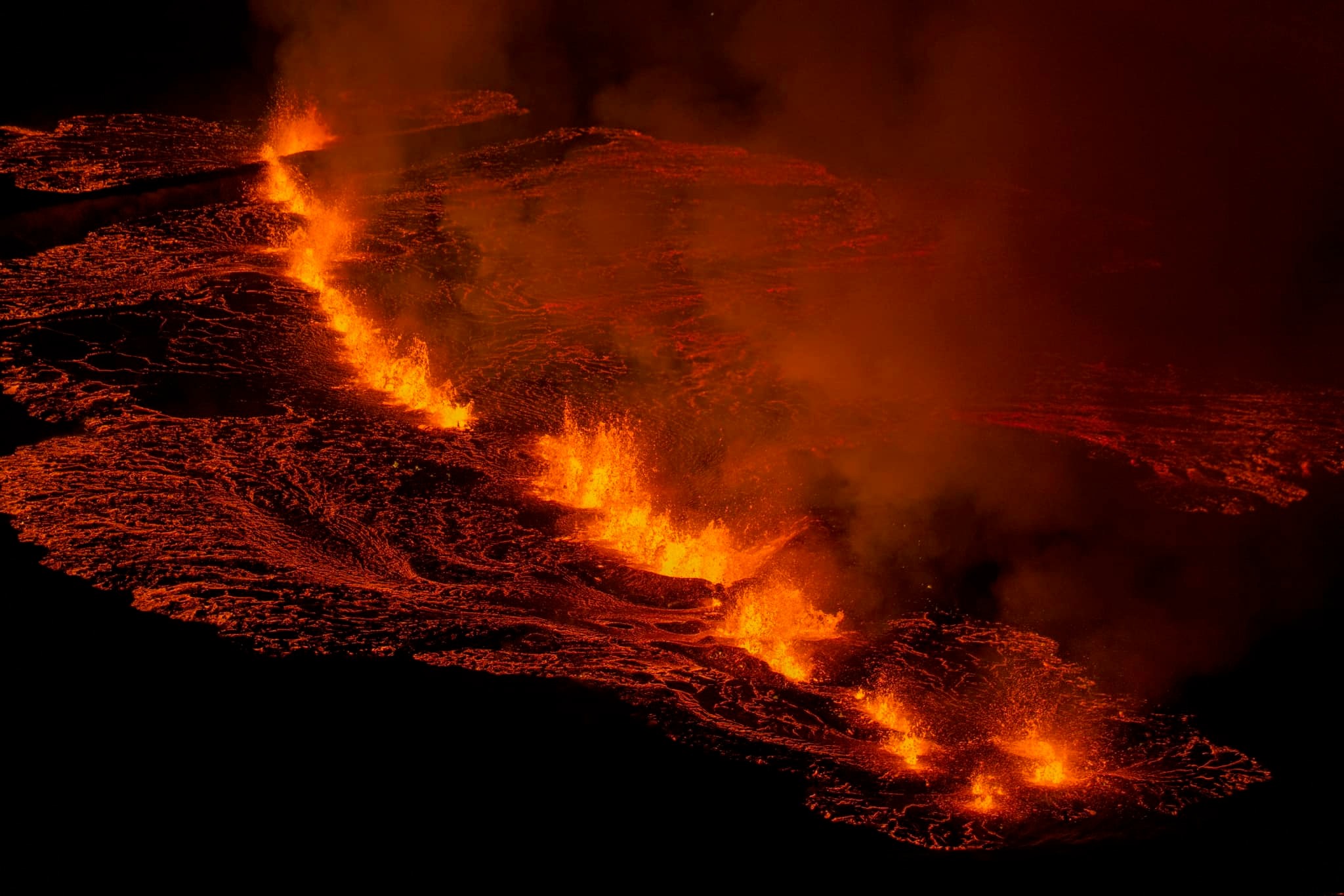
Based on webcam footage, it is evident that the lava flow has decreased from the eruptive fissures that opened yesterday. Flow from the southern eruptive fissure, which emerged around noon yesterday near the town‘s border, seems to have ceased. The majority of the remaining lava flow is now directed southwest along the protective barriers, and its trajectory seems to have stabilized.
It is difficult to estimate how long this eruption will last. Seismic activity has decreased, and GPS measurements indicate that the rate of deformation in the area has reduced. However, deformation is still detected near the southernmost part of the magma conduit beneath Grindavík.
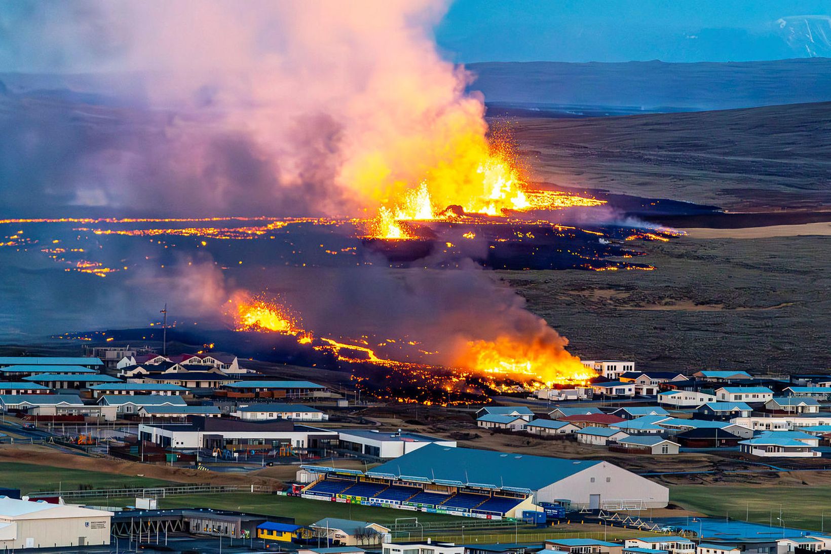
Measurements indicate that there has been a displacement of up to 1.4 meters in the past 24 hours, distributed across numerous fissures within the town‘s boundaries. Fresh fissures have developed, and existing ones have expanded. It is possible that additional fissures may emerge on the surface in the next few days.
As previously stated, the eruption sites are extremely hazardous, and the possibility of new fissures emerging without warning cannot be dismissed. This was demonstrated by the eruptive fissure that appeared near the border of Grindavík yesterday, which provided no recognizable warning signs on the monitoring equipment.
Today, there is a mild wind from the northeast at the eruption sites, but it will pick up speed later in the day. Therefore, gas pollution is drifting southwest towards the ocean. Tomorrow, the area will experience winds from the north reaching 10-18 m/s, causing the gas to drift south. Refer to the weather service’s forecast for gas dispersion details.
The Icelandic Meteorological Office continues to monitor the area and is in direct contact with civil protection and response teams in the region about the progression of the event.
Scientists met this morning for a consultation meeting organized by the Icelandic Meteorological Office. They reviewed the most recent data related to the eruption.
In the upcoming days, there will be ongoing measurements and the collection of additional data, followed by analysis. These data are being utilized, among other things, to construct models that enhance comprehension of the pre-eruptive indicators that led up to this event and to evaluate the most likely progression of the eruption. Comparisons are also being made between the December 18 eruption and the eruption that began yesterday to enhance understanding of changes in the area and to evaluate the most likely scenarios going forward.
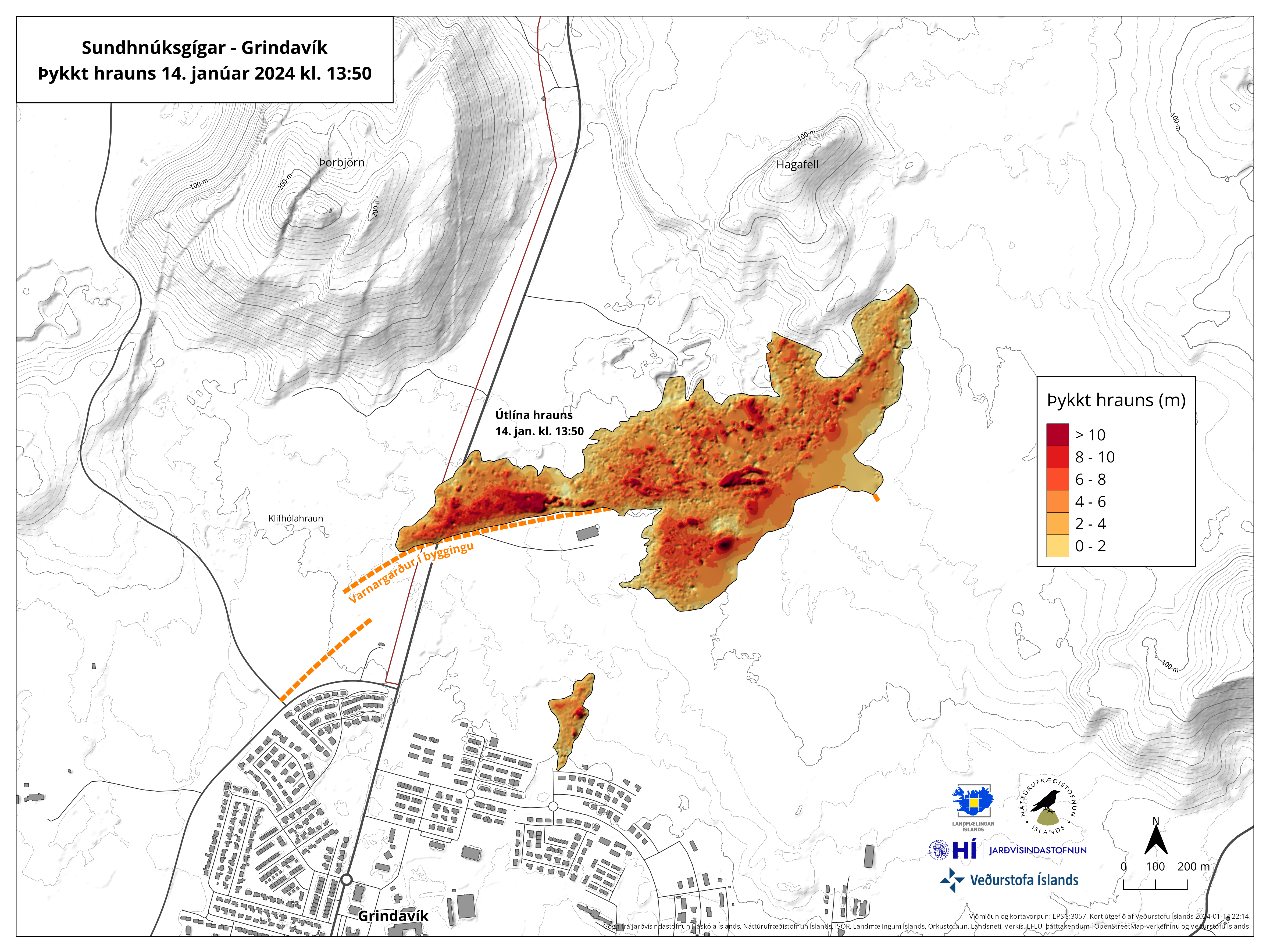
Map exhibiting the thickness of the lava flow based on measurements at 13:50 yesterday.
The Icelandic Meteorological Office has issued an updated hazard assessment map based on the latest data. It remains unchanged from the last update. The map is valid until 19:00 on Wednesday, January 17, unless new developments arise.
Source : IMO
Photos : Auteur inconnu , RAX – Ragnar Axelsson , IMO
Peru , Sabancaya :
Analysis period: from January 8, 2024 to January 14, 2024, Arequipa, January 15, 2024
Alert level: ORANGE
The Geophysical Institute of Peru (IGP) reports that the eruptive activity of the Sabancaya volcano remains at moderate levels, that is, with the recording of an average of 50 daily explosions, with columns of ashes and of gas up to 2000 m altitude above the summit of the volcano and their subsequent dispersion. Consequently, the volcanic alert level remains at the ORANGE level
The IGP recorded and analyzed the occurrence of 280 earthquakes of volcanic origin, associated with the circulation of magmatic fluids inside the Sabancaya volcano, as well as earthquakes linked to the fracturing of rocks. An average of 50 explosions were recorded daily.
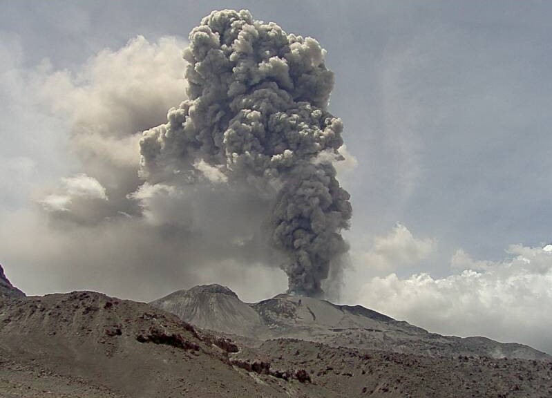
Columns of ash and gas have been observed at an altitude of up to 2000 m above the summit of the volcano. The predominant direction of these emissions was towards the West and North West sectors of the volcano over a distance of less than 10 KM.
We continue to record a slight inflation process in the northern sector (around the Hualca Hualca volcano).
Satellite recordings identified the presence of 20 thermal anomalies, with a maximum value of 15 MW, associated with the presence of a lava body on the surface of the volcano crater.
RECOMMENDATIONS
• Keep the volcano alert level in orange.
• Do not approach within a radius of less than 12 km from the crater.
Source : Cenvul.
Photo : Ingemmet
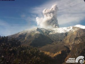
Chile , Villarica :
Special Report on Volcanic Activity (REAV), La Araucanía and Los Ríos regions, Villarrica volcano, January 15, 2024, 11:30 a.m. local time (mainland Chile)
The National Geology and Mining Service of Chile (Sernageomin) announces the following PRELIMINARY information, obtained through the monitoring equipment of the National Volcanic Monitoring Network (RNVV), processed and analyzed at the Southern Andean Volcano Observatory (Ovdas):
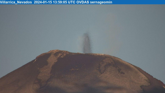
On Monday January 15, 2024, at 8:30 a.m. local time (11:30 a.m. UTC), through monitoring stations installed near the Villarrica volcano, Strombolian-type explosions of maximum height were visualized at around 200 m above the crater with distribution of metric-sized pyroclasts in the zone proximal to this one. It should be noted the pulsatile nature, with a recurrence of 2-3 minutes and a duration of approximately 20 seconds per event. Activity continues at the time of writing this report.
Observation :
Activity continues at the time of writing this report.
The technical volcanic alert is maintained at YELLOW level.
Source et photo : Sernageomin.
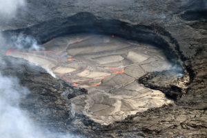
Alaska , Shishaldin :
Low-level unrest continues at Shishaldin Volcano. Seismic activity has been low over the past day. No exposive activity was detected in infrasound data. Weakly elevated surface temperatures were observed in clear satellite views. Weak steaming was observed from the summit in clear web camera views.
Thirteen significant explosive events occurred at Shishaldin from July 12 through November 3, 2023. These events were preceded by increases in seismicity in the hours to days before they occurred. It is unknown how long this period of ongoing activity will last. However, previous eruptions of Shishaldin Volcano have lasted weeks to months with repeated cycles of eruptive activity like those seen since July.

Local seismic and infrasound sensors, web cameras, and a geodetic network monitor Shishaldin Volcano. In addition to the local monitoring network, AVO uses nearby geophysical networks, regional infrasound and lighting data, and satellite images to detect eruptions.
Source : AVO
Photo : Nick Enloe.
Indonesia , Lewotobi Laki Laki :
The Lewotobi Laki-Laki volcano on the Indonesian island of Flores erupted on Monday around 1:20 p.m. local time, throwing ash up to 1,500 meters above its peak, the country’s Center for Volcanology and Geological Hazard Mitigation (PVMBG) said in a statement on Monday.
Mount Lewotobi Laki-Laki has been at Level IV, the country’s highest danger level for a volcano since Tuesday last week, indicating that an eruption could threaten settlements around the volcano.
The PVMBG has called on the public not to carry out any activities within a radius of 4 kilometers from the center of the eruption, with an expanded sector of 5 km in the northwest and north. It has also warned of the potential for cold lava surging into rivers upstream from the peak in case of intense rain.
Standing as high as around 1,584 meters above sea level, Lewotobi Laki-Laki is a twin volcano with the other one called Lewotobi Perempuan, located in the southeast part of Flores island.
Since early this month, the PVMBG has recorded 25 eruptions of Lewotobi Laki-Laki, making it the volcano with the most eruptions this year in the Southeast Asian country.
Amid the volcano’s eruption, more than 6,500 villagers living near the volcano were evacuated for their safety.
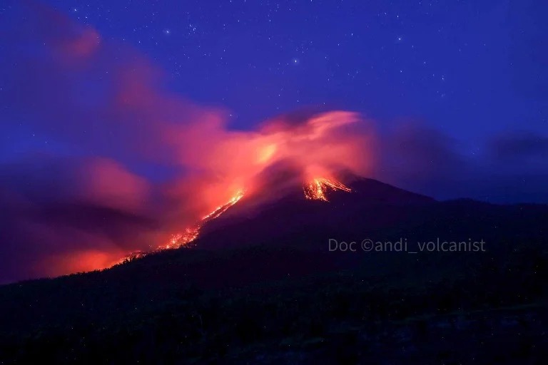
15- 16th Jan 2024. Lewetobi volcano, Flores, Indonesia.
Remain produce lava flows mostly to the east and ash explosions in its crater.
Lava flows reached until 2 km and burned some forest. Rumbling could be heard 5 km from the crater and ash spread might shut the airport in Larantuka city ( 68 km) and even to Maumere ( 74 km).
Viewed Left side is Lewetobi perempuan ( female) is dorman level II and right side is Lewetobi Laki-laki erupting since 23th Dec 2023
Sources : news cgtn.com , Andi Volcanist
Photo : Andi Volcanist