November 17 , 2021 .
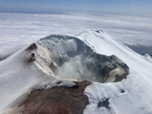
Philippines , Taal :
TAAL VOLCANO ADVISORY 17 November 2021 3:30 AM
Two short-lived phreatomagmatic bursts at the Taal Main Crater were recorded this morning at 1:46 AM & 2:54 AM that lasted 1 and 2 minutes, respectively, based on the seismic signals. These events produced plumes 400 to 500 meters tall based on thermal camera monitoring. There have been three phreatomagmatic bursts since November 15 that are likely driven by fracturing and gas release from resting magma beneath the Taal Volcano Island.
DOST-PHIVOLCS reminds the public that Alert Level 2 (Increased Unrest) prevails over Taal Volcano and that sudden steam- or gas-driven explosions, volcanic earthquakes, minor ashfall, and lethal accumulations or expulsions of volcanic gas can occur and threaten areas within and around TVI. At Alert Level 2, entry into Taal Volcano Island, Taal’s Permanent Danger Zone or PDZ especially the vicinities of the Main Crater and the Daang Kastila fissure, and extended stay on Taal Lake, must be strictly prohibited. Local government officials are advised to continuously assess and strengthen the preparedness of previously evacuated barangays around Taal Lake in case of renewed unrest. Civil aviation authorities must advise pilots to avoid flying close to the volcano as airborne ash and ballistic fragments from sudden explosions and wind-remobilized ash may pose hazards to aircraft. DOST-PHIVOLCS is closely monitoring Taal Volcano’s activity and any new significant development will be immediately communicated to all stakeholders.
Source : Phivolcs
Photo : Richard Langford
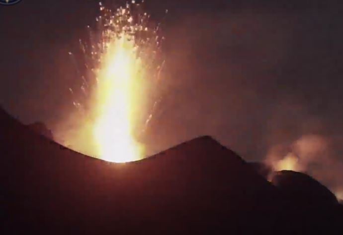
Italy , Stromboli :
Weekly bulletin, from November 08, 2021 to November 14, 2021. (issue date November 16, 2021)
SUMMARY OF ACTIVITY
In view of the monitoring data, it is highlighted:
1) VOLCANOLOGICAL OBSERVATIONS: During this period a normal explosive activity of strombolian type with splash activity was observed. The total hourly frequency of explosions fluctuated between medium-high and high values (17-21 events / h). The intensity of the explosions varied from low to medium in the areas of the North and Center-South crater.
2) SEISMOLOGY: The seismological parameters monitored do not show significant variations.
3) DEFORMATIONS: No significant variation in the data from inclinometric and GNSS networks.
4) GEOCHEMISTRY: The flow of SO2 at an average level
There is no update of the values of the CO2 flow emitted by the ground on the Pizzo compared to the previous bulletin. Restoration of the data transmission system is in progress.
There are no updated values of the C / S ratio from the previous bulletin, in which the values were at average levels.
There is no update of the isotopic ratio of Helium dissolved in the thermal aquifer of Stromboli. New sampling is in progress.
5) SATELLITE OBSERVATIONS: The thermal activity in the summit area is at a low level.
VOLCANOLOGICAL OBSERVATIONS
During the observation period, the eruptive activity of Stromboli was characterized by the analysis of the images recorded by the surveillance cameras of the INGV-OE (altitude 190, Punta
Corvi, altitude 400 and Pizzo). The explosive activity was mainly produced by 5 (five) eruptive vents located in the area of the North crater and 4 (four) eruptive vents located in the area of the
Center-South crater. All the vents are placed inside the depression which occupies the terrace of the crater (Fig. 3.1).
Due to adverse weather conditions, the visibility of the crater terrace on November 10 and 11 was insufficient for a correct description of the explosive activity.
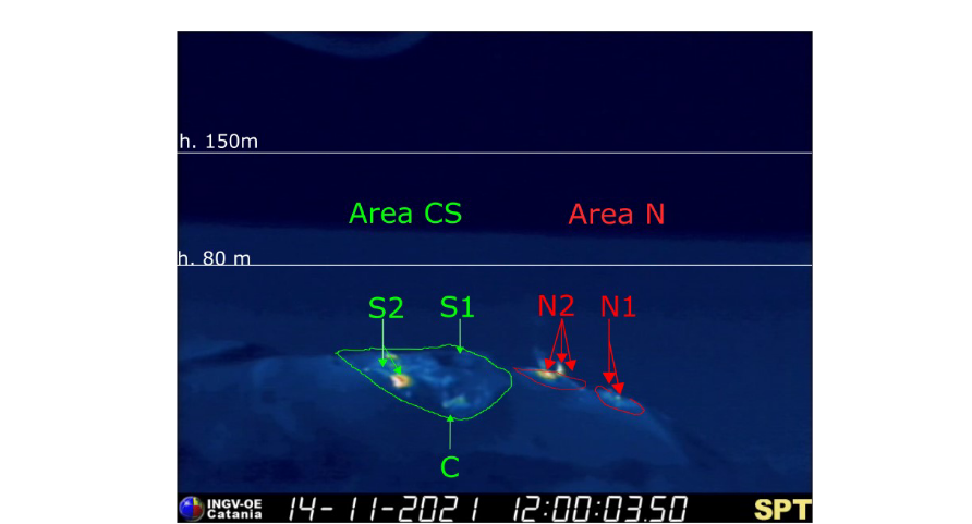
Fig. 3.1 – The crater terrace seen from the thermal camera placed on the Pizzo sopra la Fossa with the delimitation of the zones of the crater Zone Center-South and Zone North (ZONE N, ZONE C-S respectively). Abbreviations and arrows indicate the names and locations of active vents, the area above the crater terrace is divided into three height ranges relating to the intensity of the explosions.
Sector N1, with two emission points, located in the area of the North crater produced explosions of mainly medium-low intensity (sometimes the products of the explosions exceeded 80 m in height) emitting coarse materials (lapilli and bombs) . In addition, intense splashing activity was observed from the mouth overlooking the Sciara del Fuoco, for short periods, on November 8 and 12. Sector N2, with three emission points, showed explosive activity of low intensity (less than 80 m high) and medium intensity (less than 150 m high) emitting coarse materials with sometimes intense projection activity on November 8, 9 and 14. The average frequency of explosions varied from 10 to 15 events / h.
In the Center-South zone, sectors S1 and C did not show significant explosive activity, while the two vents located in sector S2 produced explosions, even simultaneously, of medium-low intensity (sometimes the explosive products exceeded 80 m in height) emitting coarse matter. The frequency of the explosions varied from 6 to 7 events / h.
Source : INGV.
Photo : Webcam.
Spain/ La Palma , Cumbre Vieja :
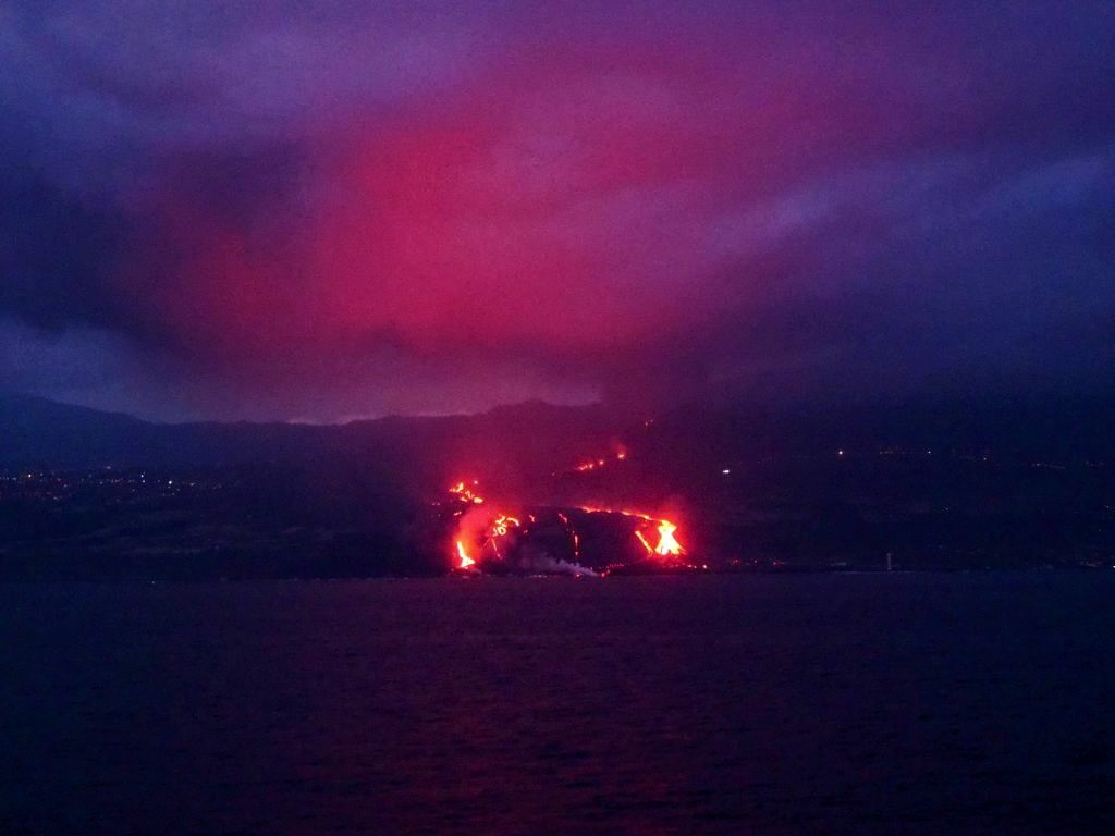
November 16, 2021, 10:00 UTC. Eruptive activity continues on La Palma.
Since the last declaration, 33 earthquakes have been located in the area affected by volcanic reactivation on the island of La Palma.
The hypocenters are located in the two areas of recent activity, both below the central area of Cumbre Vieja, a first group at depths of 10-15 km and a second group at depths greater than 30 km.
The largest earthquake was recorded at 1:01 am today with a magnitude of 3.8 mbLg and located 38 km deep.
The tremor signal remains in a low value range, similar to the previous days.
The island’s network of permanent GNSS stations shows that after reversing the inflation on days 4 and 5 in station LP03, which is closest to the eruptive centers, remains at a lower level than previously established. On the other hand, the station continues to record a slight deformation towards the South. In the rest of the stations, the slight deflation possibly linked to the deep seismicity has stabilized.
In view of the calibrated image, a column height of 3000 m is estimated. at 08:45 UTC with an ash cloud heading east.
The technical director of the Volcanic Emergency Plan of the Canary Islands (Pevolca), Miguel Ángel Morcuende, underlined on Tuesday the significant decrease in sulfur dioxide emissions from the eruption of the volcano of La Palma, a decrease which “confirms the general trend Of the last few days. « The trends are stabilized, » said María José Blanco, director of the National Geographical Institute of the Canary Islands (IGN), referring to the energy of the system. “This is in a more stable process, but in the short term the eruption is not going to end. Yesterday’s sulfur dioxide emissions were estimated to be 3,000 to 3,500 tonnes in 24 hours. In the case of carbon dioxide, the amount emitted is between 2,000 and 2,500. Here are the most remarkable data of the development of the eruption after the Pevolca officials meeting:
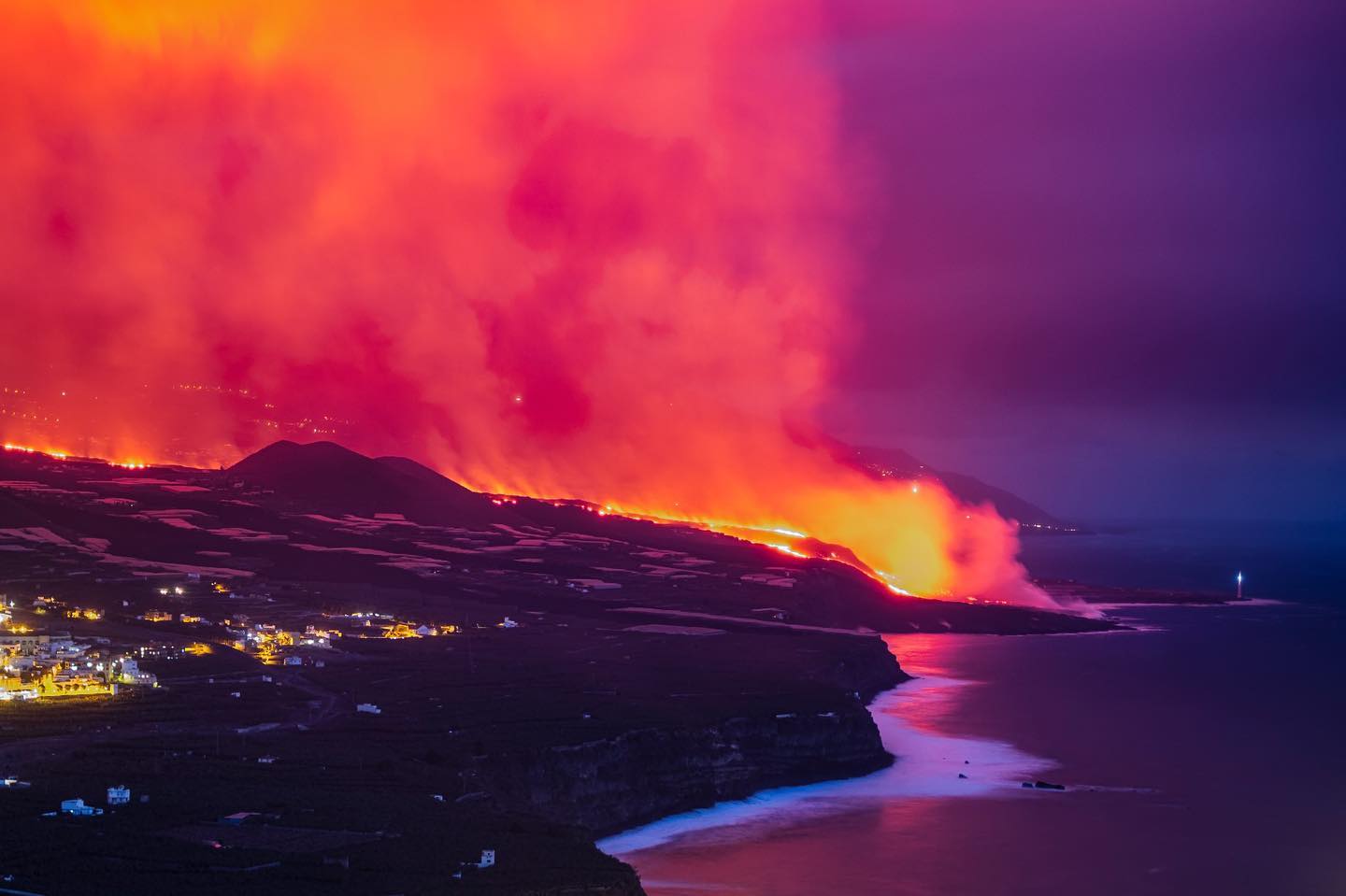
– The fissure eruption continues to show a Strombolian mechanism, that is to say a mechanism of mixed character, with phases of variable explosiveness which produce pyroclastic deposits and effusive phases which produce lava flows, simultaneously .
– System energy continues to show a declining trend in recent days, although ash contribution remains high. We note a rebound in the seismicity recorded from noon yesterday, but the values remain low at intermediate levels compared to the previous days. the earthquake of greater intensity was recorded at 1:01 a.m., 38 kilometers deep, with a magnitude of 3.8. It was not felt by the population.
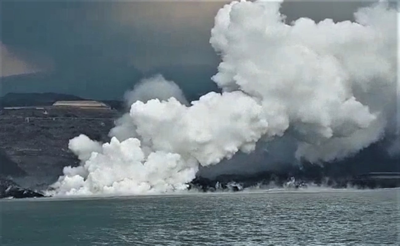
– The contribution of lava to the deltas continues, but with less affection for the marine environment than in previous days.
– There are no vertical movements of the surface.
– In the plume was measured between 3,000 and 3,500 tons in 24 hours of sulfur dioxide. With regard to carbon dioxide, it is estimated that 2,000 to 2,500 tonnes were emitted during the same period.
– The wind regime will establish itself towards the West / South-West and could affect La Palma airport. In the early hours of Tuesday, the build-up of ash prevented operations at the airport, but it has already returned to normalcy. Particulate matter mainly affects Los Llanos de Aridane, a situation caused by clean-up and ash removal.
– The affected area already amounts to 1,034 hectares, of which 14.53 hectares on the last day. The lava delta has an area of 41.99 hectares, according to data from the Instituto Geológico y Minero.
Source : IGN es , El Pais .
Photos : Patrice Zwenger , Alvaro Armas fotógrafo via Nadin Hubrich , Involcan.
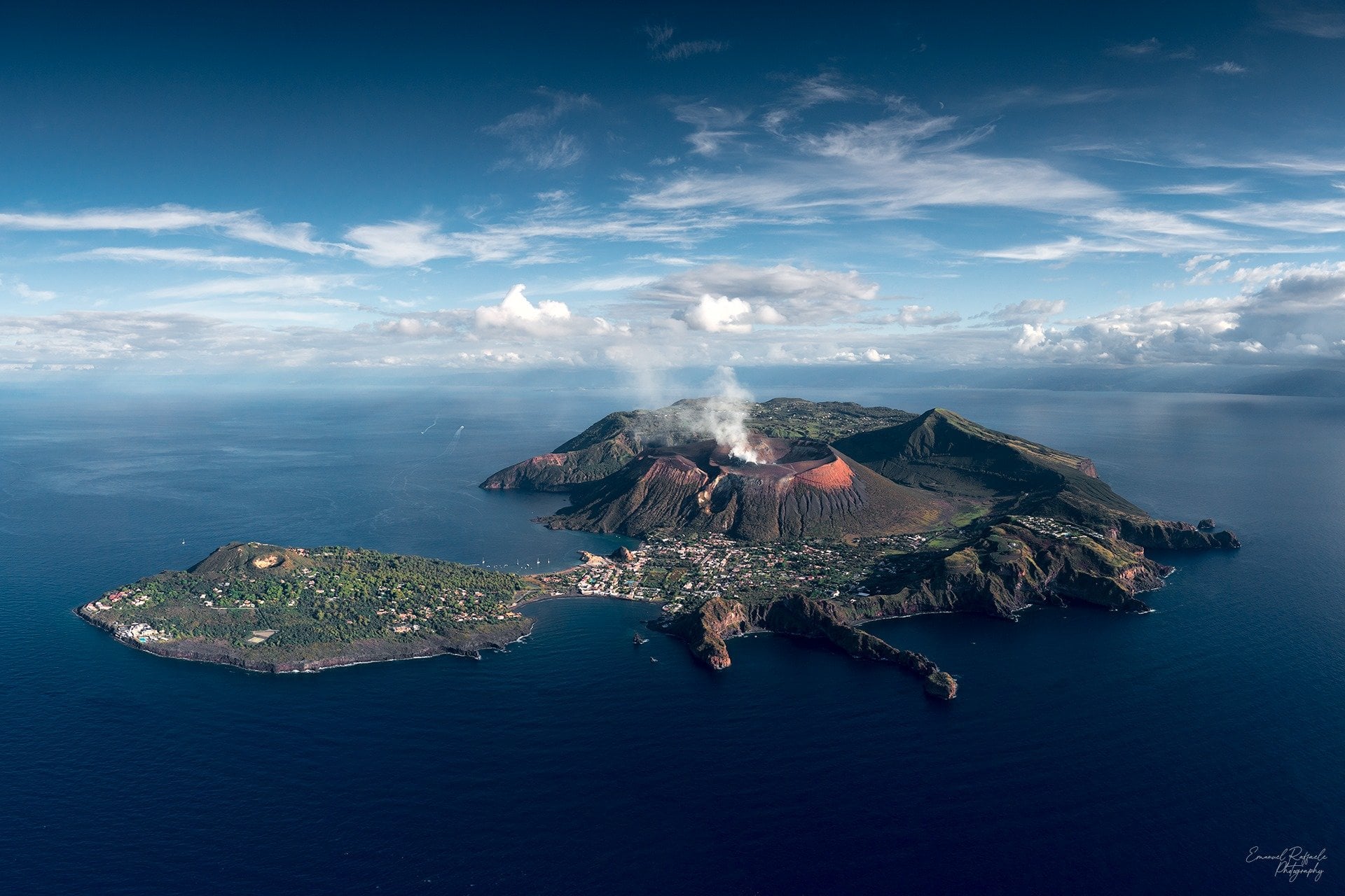
Italy , Vulcano :
WEEKLY BULLETIN from November 08, 2021 to November 14, 2021, (publication date November 16, 2021)
SUMMARY OF ACTIVITY
In view of the monitoring data, it is highlighted:
1) Temperature of the fumaroles of the crater: The temperatures recorded on the edge of the crater and on the inner flank of the cone, were disturbed by intense rains during the week when they changed the validity of the signal on the edge of the crater ( T_2, T_3). Inside (T_0), the values remain stable, in accordance with the previous bulletin.
2) CO2 flux in the crater area: Decreasing values but still at very high and abnormal levels (10000g / m2 / day).
3) SO2 flow in the crater area: SO2 flow occurs at a high level of degassing
4) Geochemistry of fumarolic gases: Sampling of fumarolic gases is scheduled for November 18, 2021
5) CO2 flow at the base of the La Fossa cone and in the Vulcano Porto area: The flow measurements at the base of the cone, acquired automatically by the VULCANOGAS network, continue to show high values.
6) Geochemistry of thermal aquifers: temperature and conductivity values slightly increasing in well C. Sicily; the temperatures recorded are anyway on very high values while the conductivity is on very low values.
7) Local seismicity: The phase of local seismicity reduction continues, with particular reference to low frequency type events (VLP).
8) Regional seismicity: low-level fracturing seismicity: 1 single earthquake with Ml = 1.2
9) Deformations – GNSS: The surface dilation of the triangle IVCR-IVLT-IVUG does not show any variants. In the North-South component of the IVCR station, there is still extremely modest recovery from expansion in the north direction.
10) Deformities – Clinometry: No significant change to report
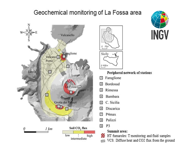
11) Other observations: CO2 fluxes: The last exploration of CO2 fluxes showed a modest surface extension of the anomalous area of Camping Sicilia, an intensification of the anomaly present in the area of Grotta dei Palizzi and a modest increase in flow in the Vulcano Porto area.
Gravimetry: Continuous measurements highlight the presence only of local gravimetric variations excluding mass redistributions at depth.
CRATER FUMEROLs TEMPERATURE..
The signals acquired by the Vulcra station (signals T_2 and T_3 in the figure) have been characterized during the last week by a strong noise caused by repeated rains; this made the data validation discontinuous. It follows that after a recorded maximum of 390 ° C on July 11, 2021, in fumarole T_2, there was a drop to 310 ° C. Similarly, for the T_3 fumarole, after a peak around 350 ° C on November 14, 21, a drop to 323 ° C is reported. On the other hand, the temperatures continuously monitored on the internal side (Vulcra2 station, signal T_0 in the figure) remain appreciably stable around 110 ° C; It should be noted that from October 12 this last sensor no longer provides reliable values (T_0 sensor of the Vulcra2 station) indicating a failure of the sensor or of the data transmission line.
CO2 FLOWS IN THE CRATER ZONE
After the extraordinary maintenance intervention carried out on April 11, 2021, the CO2 flow automatically recorded in the VCS site shows a modest drop, recording average values of 10,000 g / m2 / day in the last few days; these values, although lower than in October, are still high and at abnormal degassing levels.
Source : INGV.
Carte : ingv.
Photo : Emanuel Raffaele Photography.
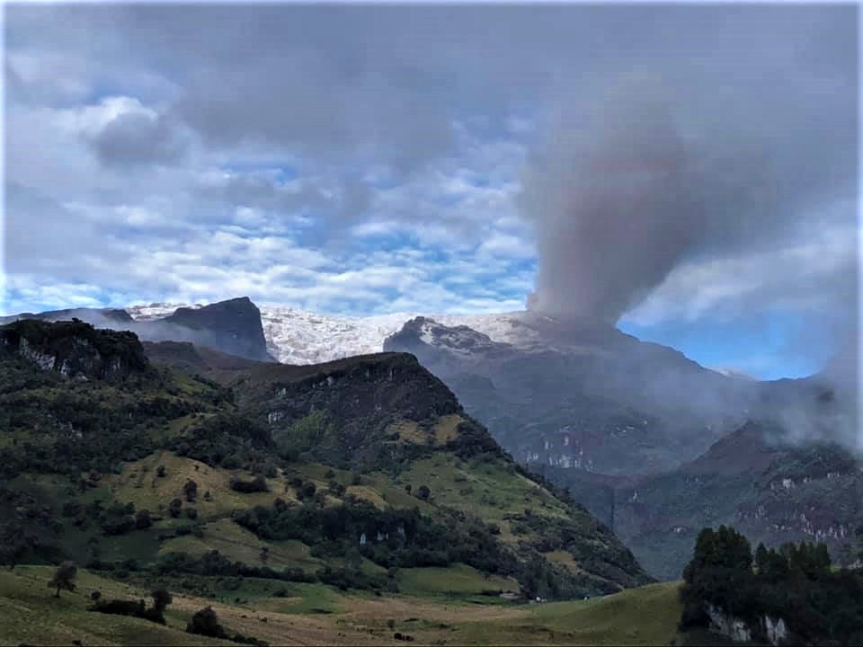
Colombia , Nevado del Ruiz :
Weekly activity bulletin of the Nevado del Ruiz volcano
The activity level continues at: Yellow activity level or (III): Changes in the behavior of volcanic activity.
Regarding the monitoring of the activity of the Nevado del Ruiz volcano, the COLOMBIAN GEOLOGICAL SERVICE reports that:
The seismicity related to the dynamics of the fluids inside the volcanic conduits presented an increase in the number of recorded earthquakes and the seismic energy released compared to the
previous week. This seismic activity was characterized by the appearance of continuous volcanic tremor, tremor pulses, earthquakes of long and very long period types, which presented moderate to low energy levels and variable spectral content. These earthquakes were located mainly in the Arenas crater. Some of these signals were associated with ash emissions, confirmed by cameras installed in the volcano area and by the report of Los Nevados National Natural Park officials and Colombian Geological Service staff working in the field.
The seismicity generated by the fracturing of the rock increased the number of earthquakes and showed a slight decrease in the seismic energy released compared to the previous week. This seismic activity was located mainly in the South-South-West and North-North-West sectors of the volcano and in the Arenas crater. The depths of the earthquakes ranged from 0.9 to 7.4 km. Two slight increases in this type of seismicity can be seen yesterday and at sunrise today, in the South-South-West and North-North-West sectors of the volcano, approximately 3.5 km and 6.5 km respectively from Arenas crater.
The maximum magnitude recorded during the week was 1.9 ML (Local Magnitude) corresponding to the earthquake recorded on November 15 at 11:49 p.m. (local time) during one of the aforementioned increases, this earthquake was located 3.5 km au South-southwest of the Arenas Crater, 4.0 km deep.
Source : SGC
Photo : Ramirez Jorge