January 04 , 2024.
Colombia , Nevado del Ruiz :
Manizales, January 3, 2024 1:10 p.m.
Regarding the monitoring of the activity of the NEVADO DEL RUIZ VOLCANO, the COLOMBIAN GEOLOGICAL SERVICE, an entity attached to the MINISTRY OF MINES AND ENERGY, reports that:
As of 10:06 a.m. Today, January 3, 2024, an increase in seismic activity associated with fracturing of rocks inside the volcano was recorded, approximately 3 km northwest of Arenas Crater. Up to the time of publication of this bulletin, 600 earthquakes have been recorded and a maximum magnitude of 3.9 corresponding to an earthquake that occurred at 11:03 a.m. and reported as felt by the managers of the Los Nevados Natural National Park, the SGC staff in the field work and by the inhabitants of the zones of influence near the volcano and in the city of Manizales. In addition to these earthquakes, the occurrence of earthquakes related to fluid activity inside the volcano and certain thermal anomalies or temperature increases at the bottom of the crater continues.
Although currently the Nevado del Ruiz volcano remains in a state of yellow alert and seismic increases in its activity are envisaged in this state, these testify to its variable and unstable behavior, and for this reason it is important to do not normalize them. Although this state of alert for volcanic activity indicates that the volcano presents less instability and, therefore, the probability of a considerable eruption is lower, at any time it can destabilize rapidly, which would lead to move to an orange or even red alert state.
The community is recommended to remain calm and pay attention to the information provided by the Colombian Geological Service on the evolution of the state of the volcano.
The COLOMBIAN GEOLOGICAL SERVICE will continue to monitor the evolution of the volcanic phenomenon and will inform in a timely manner of any changes that may occur.
The volcano’s alert status remains at YELLOW ALERT: ACTIVE VOLCANO WITH CHANGES IN THE BEHAVIOR OF THE BASE LEVEL OF MONITORED PARAMETERS AND OTHER MANIFESTATIONS
Source : SGC
Iceland , Reykjanes Peninsula :
Earthquakes near Trölladyngja
The largest earthquake was 4.5 in magnitude, according to initial data. Shortly afterwards, a magnitude 3.9 earthquake occurred
Updated 4 January at 12:30 UTC
At 10:50 AM, an earthquake of magnitude 4.5 occurred near Trölladyngja, followed shortly by another earthquake measuring 3.9 at 10:54 AM and a series of aftershocks. The earthquakes occurred at a depth of approximately 5 km and were likely triggered in response to stress released from earth movement elsewhere on the Reykjanes Peninsula. These earthquakes were widely felt in the southwest region of Iceland.
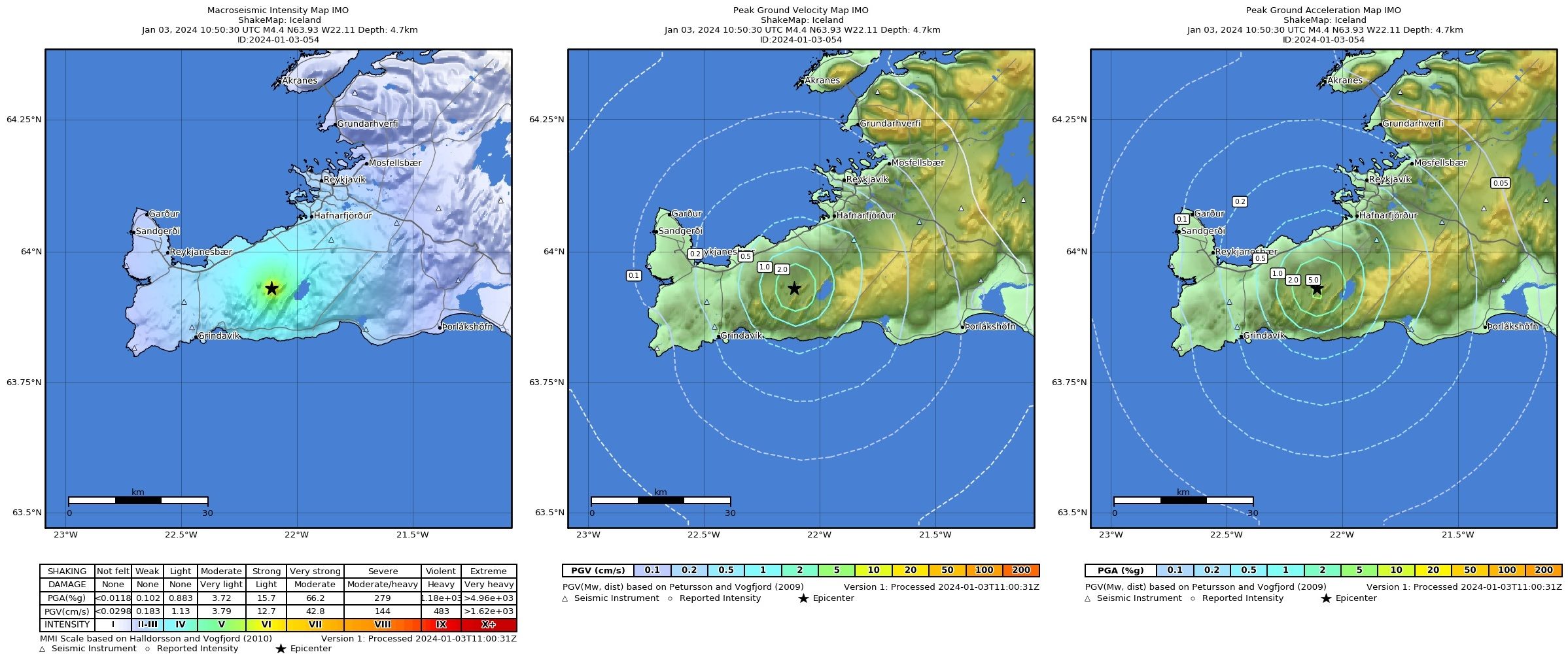
The location of the earthquakes is about 20 km NNE of Svartsengi, where land rise due to magma accumulation is ongoing.
The accompanying image shows the location of the earthquake that occurred at 10:50 AM and its impact area.
Source et photo : IMO.
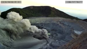
Chile , Villarica :
Special Report on Volcanic Activity (REAV), La Araucanía and Los Ríos regions, Villarrica volcano, January 4, 2024, 8:30 p.m. local time (mainland Chile)
The National Geology and Mining Service of Chile (Sernageomin) announces the following PRELIMINARY information, obtained through the monitoring equipment of the National Volcanic Monitoring Network (RNVV), processed and analyzed at the Southern Andean Volcano Observatory (Ovdas):
On Thursday January 4, 2024, at 10:00 p.m. local time (01:00 UTC), monitoring stations installed near the Villarrica volcano recorded an earthquake associated with the fracturing of rocks inside the volcanic system (volcano-tectonic type).
The characteristics of the earthquake after its analysis are as follows:
ORIGINAL TIME: 10:00 p.m. local time (01:00 UTC)
LATITUDE: 39.441°S
LONGITUDE: 71.852°E
DEPTH: 3.8 km
LOCAL MAGNITUDE: 3.4 (ML)
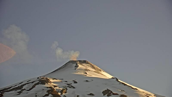
Observation :
The high energy volcano-tectonic (VT) event mentioned in this report occurred as part of an ongoing seismic swarm that could lead to other lower energy events of the same type.
No changes in fluid behavior or associated surface activity were recorded.
The technical volcanic alert is maintained at YELLOW level.
Source et photo : Sernageomin.
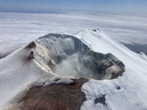
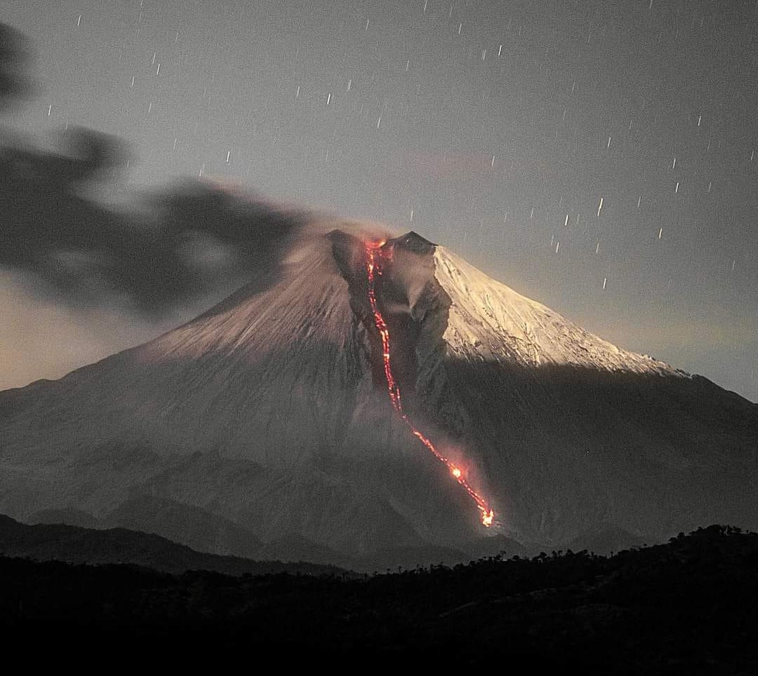
Ecuador , Sangay :
DAILY REPORT ON THE STATE OF THE SANGAY VOLCANO, Thursday January 4, 2024.
Information Geophysical Institute – EPN.
Surface activity level: High, Surface trend: Descending
Internal activity level: High, Internal trend: No changes
Seismicity: From January 3, 2024, 11:00 a.m. to January 4, 2024, 11:00 a.m.:
The number of seismic events recorded at the reference station over the past 24 hours is shown below. The level of seismic activity of the volcano remains high.
Explosion Event (EXP): 391
Precipitation/Lahars:
Rains were recorded in the volcano area without generating mudslides or debris. Heavy rains could remobilize accumulated material and generate mud and debris flows that would flow down the volcano’s flanks and flow into adjacent rivers.
Emissions/ash column:
Due to bad weather conditions, thanks to the surveillance camera, only two emissions of gas and ash were observed with heights of 900 and 300 meters above the level of the crater in the southwest direction. On the other hand, thanks to the GOES-16 satellite system, emissions were recorded at heights less than 800 meters above the level of the crater in a southwest direction. The Washington VAAC has not issued any emissions reports in the past 24 hours.
Other monitoring parameters:
The FIRMS satellite system recorded 3 thermal anomalies. The MIROVA-MODIS satellite system recorded 1 moderate thermal anomaly. The MIROVA-VIIRS satellite system recorded 2 moderate thermal anomalies and 1 weak thermal anomaly over the last 24 hours.
Observation:
During yesterday night and early today, several episodes of expulsion of incandescent material were recorded which reached 400 meters above the level of the crater, and the descent of material through the southeast ravine up to 1,800 meters below the level of the crater. At the time of closing this report, the volcano is completely cloudy.
Alert level: yellow
Source : IGEPN.
Photo : Eqphos fotografía.
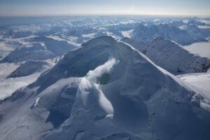
Alaska , Kanaga :
51°55’27 » N 177°9’44 » W,
Summit Elevation 4288 ft (1307 m)
Current Volcano Alert Level: ADVISORY
Current Aviation Color Code: YELLOW
Clouds obscured clear views of the volcano in satellite and web camera images over the last day. Local web cameras and seismic data are temporarily offline due to a power failure.
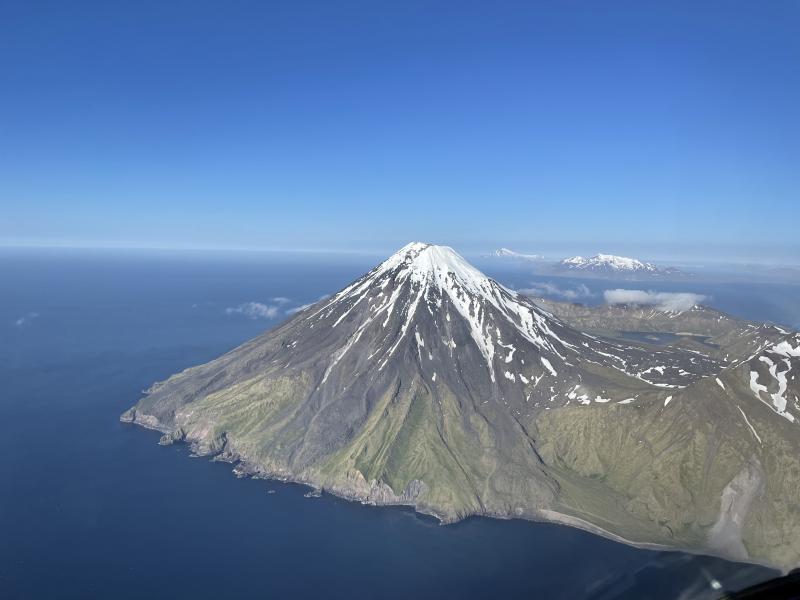
The recent unrest indicates a possibility for sudden explosions of ash to occur at any time, and ash clouds exceeding 20,000 feet above sea level may develop. Kanaga Volcano is monitored by local seismic and infrasound sensors, regional infrasound and lightning networks, and satellite data.
Symmetrical Kanaga stratovolcano is situated within the Kanaton caldera at the northern tip of Kanaga Island. The caldera rim forms a 760-m-high arcuate ridge south and east of Kanaga; a lake occupies part of the SE caldera floor. The volume of subaerial dacitic tuff is smaller than would typically be associated with caldera collapse, and deposits of a massive submarine debris avalanche associated with edifice collapse extend nearly 30 km to the NNW. Several fresh lava flows from historical or late prehistorical time descend the flanks of Kanaga, in some cases to the sea. Historical eruptions, most of which are poorly documented, have been recorded since 1763. Kanaga is also noted petrologically for ultramafic inclusions within an outcrop of alkaline basalt SW of the volcano. Fumarolic activity occurs in a circular, 200-m-wide, 60-m-deep summit crater and produces vapor plumes sometimes seen on clear days from Adak, 50 km to the east.
Source : AVO
Photo : Boyce, Ellie/ Alaska Volcano Observatory / University of Alaska Fairbanks, Geophysical Institute.