February 13 , 2024.
Alaska , Gareloi :
Current Volcano Alert Level: ADVISORY
Previous Volcano Alert Level: NORMAL
Current Aviation Color Code: YELLOW
Previous Aviation Color Code: GREEN
Issued: Monday, February 12, 2024, 1:10 PM AKST
Source: Alaska Volcano Observatory
Notice Number: 2024/A158
Location: N 51 deg 47 min W 178 deg 47 min
Elevation: 5161 ft (1573 m)
Area: Aleutians
Volcanic Activity Summary:
Over the past several hours, AVO has detected an increase in seismicity at Mount Gareloi (Gareloi volcano) beginning at 09:15 AKST (18:15 UTC). The current activity marks a change in character above background rates, and AVO is raising the Aviation Color Code to YELLOW and Volcano Alert Level to ADVISORY.
There have been no other notable changes at the volcano in satellite data or webcam views. Mount Gareloi persistently emits magmatic gases from a fumarole field on the south crater and commonly exhibits low-level seismic activity. These observations suggest the presence of shallow magma and potential interaction with a hydrothermal system. The current increase in seismicity likely reflects a change to the magmatic-hydrothermal system, but it is not clear that the likelihood of a volcanic eruption has increased. AVO will continue to monitor activity to determine if the recent changes are related to influx of new magma or other changes to the magma system.
Mount Gareloi is monitored by a local seismic and infrasound network, satellite data, and regional infrasound and lightning-detection networks.
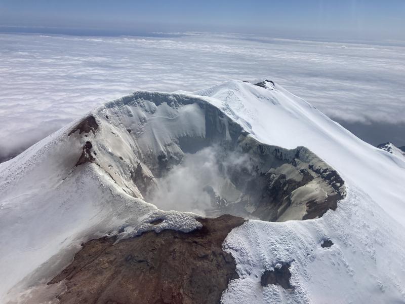
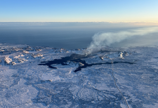
North peak crater of Gareloi Volcano, Andreanof Islands, western Aleutians.
Remarks:
Mount Gareloi, which makes up all of Gareloi Island, is a stratovolcano located in the Delarof Islands group of the Aleutian Islands, about 2,000 km (1,242 mi) west-southwest of Anchorage and about 150 km (93 mi) west of Adak, the westernmost community in Alaska. This small volcano is 10 × 8 km (6.2 × 5.0 mi) in diameter at its base with two summits, separated by a narrow saddle. The northern, slightly higher peak contains crater about 300 m (1,000 ft) across. The southern summit has a crater open to the south and a persistent degassing vent (fumarole) on its western rim. Gareloi has been one of the most active in the Aleutians since the 1740s, with 16 reports of eruptive activity at Gareloi since 1760. In 1929, its largest historical eruption produced sixteen small south- to southeast-trending craters that extend from the southern summit to the coast, as well as lava flows and pyroclastic deposits on the southeastern flank of the volcano. Eruptions of Gareloi commonly produce ash clouds and lava flows, and the primary hazard is airborne clouds of ash that could affect aircraft. Since seismic instruments were installed in 2003, they have detected small but consistent seismic signals from beneath Mount Gareloi’s edifice.
Source : AVO
Photo : Mann, Doerte / AVO / EarthScope Consortium
Iceland : Reykjanes Peninsula :
No signs of eruptive activity . Updated hazard assessment according to the development
Updated 12. February at 16:00 UTC
IMO has updated the hazard assessment according to the development of the eruptive activity. Changes have been made to the hazard assessment for some hazards within zones.
The overall hazard assessment for the area remains unchanged from the last map. There is still considered to be a sinkholes and fault movementsn area 4 (Grindavík).
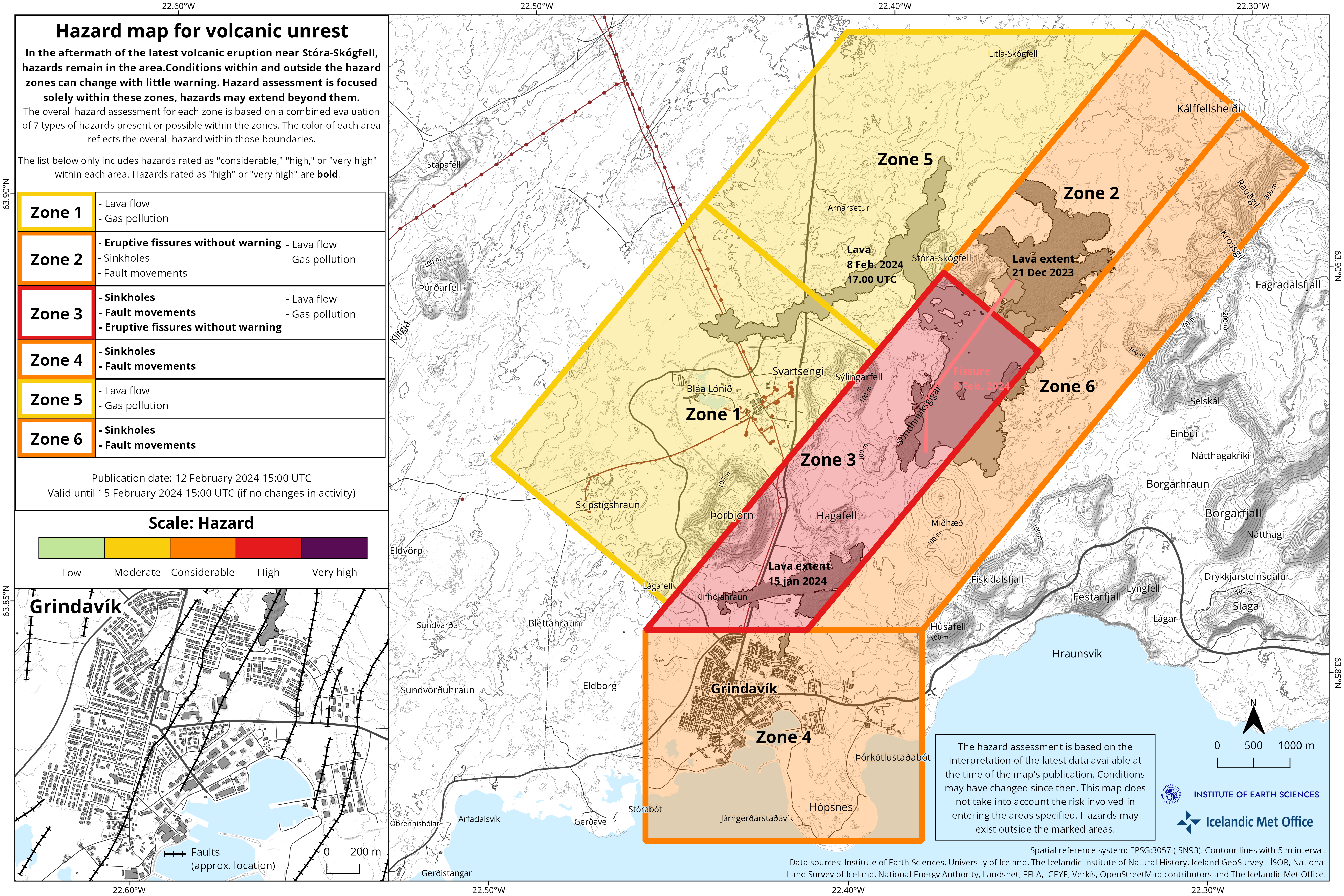
The hazard assessment map is valid until Thursday, 15 February, unless changes in activity calls for a re-evaluation.
Updated 12. February at 14:30 UTC
Inflation has started again at Svartsengi after having subsided following the eruption which started 8. February. Inflation rate is about 0.5-1.0 cm/day which is in similar to the rates detected prior to last eruptions. Magma thus continues to accumulate in the magma reservoir beneath Svartsengi. It is therefore highly likely that the cycle continues in a few weeks with another dyke propagation and a volcanic eruption.
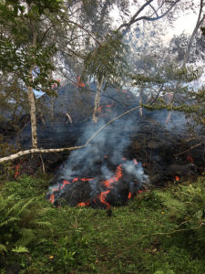
Lava from the eruption 8. February 2024. Photo: Birgir Vilhelm Óskarsson/The Icelandic Institute of Natural History.
Since noon of 8. February, seismic activity in the area north of Grindavík has been minor, about 50 small earthquakes have been detected, all of which were around or less than M1.0. A small seismic swarm has been ongoing in the western parts of Mt. Fagradalsfjall with about 100 earthquakes detected, mostly M1 events or smaller. Minor swarms in the Fagradalsfjall area have occurred frequent for the past weeks, the depth of the earthquakes is at around 6-8 km.
Source : IMO
Photos : IMO , Birgir Vilhelm Óskarsson/Institut islandais d’histoire naturelle.
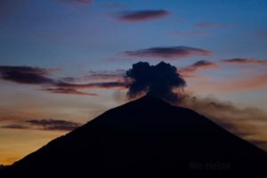
Russia / Kuril Islands , Ebeko :
VOLCANO OBSERVATORY NOTICE FOR AVIATION (VONA)
Issued: February 13 , 2024
Volcano: Ebeko (CAVW #290380)
Current aviation colour code: ORANGE
Previous aviation colour code: orange
Source: KVERT
Notice Number: 2024-08
Volcano Location: N 50 deg 41 min E 156 deg 0 min
Area: Northern Kuriles, Russia
Summit Elevation: 1156 m (3791.68 ft)
Volcanic Activity Summary:
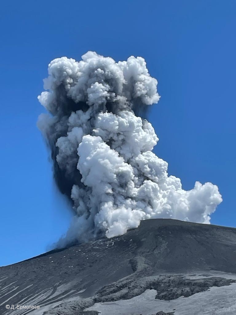
A moderate explosive eruption of the volcano continues. According to visual data from Severo-Kurilsk, explosions sent ash up to 2.5 km a.s.l., and ash cloud drifted to the north-east of the volcano.
A moderate explosive eruption of the volcano continues. Ash explosions up to 6 km (19,700 ft) a.s.l. could occur at any time. Ongoing activity could affect low-flying aircraft and airport of Severo-Kurilsk.
Volcanic cloud height:
2500 m (8200 ft) AMSL Time and method of ash plume/cloud height determination: 20240213/0100Z – Visual data
Other volcanic cloud information:
Distance of ash plume/cloud of the volcano: 5 km (3 mi)
Direction of drift of ash plume/cloud of the volcano: ENE / azimuth 70 deg
Time and method of ash plume/cloud determination: 20240213/0100Z – Visual data
Source : Kvert
Photo : D. Ermolaev ( archive)
Chile , Villarica :
Special Report on Volcanic Activity (REAV), La Araucanía and Los Ríos regions, Villarrica volcano, February 12, 2024, 8:38 p.m. local time (mainland Chile)
The National Geology and Mining Service of Chile (Sernageomin) announces the following PRELIMINARY information, obtained through the monitoring equipment of the National Volcanic Monitoring Network (RNVV), processed and analyzed at the Southern Andean Volcano Observatory (Ovdas):
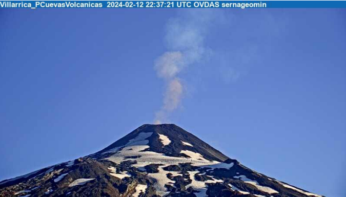
On Monday February 12, 2024, at 7:37 p.m. local time (10:37 p.m. UTC), monitoring stations installed near the Villarrica volcano recorded an earthquake associated with fluid dynamics inside the volcanic system (long period type), accompanied by a pulse of fine particles.
The characteristics of this earthquake after its analysis are as follows:
ORIGINAL TIME: 7:37 p.m. local time (10:37 p.m. UTC)
REDUCED DISPLACEMENT: 25.3 (cm*cm)
The characteristics of the associated surface activity are as follows:
MAXIMUM HEIGHT OF THE COLUMN: 420 meters above the point of emission
DIRECTION OF SPREAD: South-West (SW)
Observation :
The pulse of particulate materials is characterized by having a content of very fine ash, which dissipated quickly in the degassing column.
The technical volcanic alert is maintained at YELLOW level.
Source : Sernageomin
Photos : Sernageomin
Peru , Sabancaya :
Analysis period: from February 5, 2024 to February 11, 2024, Arequipa, February 12, 2024
Alert level: ORANGE
The Geophysical Institute of Peru (IGP) reports that the eruptive activity of the Sabancaya volcano remains at moderate levels, that is, with the recording of an average of 33 daily explosions, with columns of ash and of gas up to 2000 m altitude above the summit of the volcano. Consequently, the volcanic alert level remains at the ORANGE level
The IGP recorded and analyzed the occurrence of 345 earthquakes of volcanic origin, associated with the circulation of magmatic fluids inside the Sabancaya volcano, as well as earthquakes linked to the fracturing of rocks. An average of 33 explosions were recorded daily.

Columns of ash and gas have been observed at an altitude of up to 2000 m above the summit of the volcano. The predominant direction of these emissions was towards the East, South East and South sectors of the volcano over a distance of less than 10 KM.
We continue to record a slight inflation process in the northern sector (around the Hualca Hualca volcano).
Satellite recordings identified the presence of 12 thermal anomalies, with a maximum value of 28 MW, associated with the presence of a lava body on the surface of the volcano crater.
Moderate emissions (1285 tonnes/day) of sulfur dioxide (SO2) were observed.
RECOMMENDATIONS
• Keep the volcano alert level in orange.
• Do not approach within a radius of less than 12 km from the crater.
Source : Cenvul
Photo : Andina / Ingemmet