December 13 , 2023.
Italy , Stromboli :
WEEKLY BULLETIN, from December 4, 2023 to December 10, 2023. (issue date December 12, 2023)
SUMMARY STATEMENT OF ACTIVITY
In light of the monitoring data, it appears:
1) VOLCANOLOGICAL OBSERVATIONS: Normal Strombolian activity was observed during this period. The total hourly frequency fluctuated between average values (10-14 events/h). The intensity of the explosions was low and medium in the North Crater area and variable from low to high in the South Central area.
2) SISMOLOGY: The monitored seismological parameters do not show significant variations.
3) GROUND DEFORMATIONS: The ground deformation monitoring networks did not show significant variations over the period under examination.
4) GEOCHEMISTRY: SO2 flux at medium level
CO2 flow on average values
C/S ratio in the plume with medium-high values (last measurement on 11/19/2023)
Helium isotope ratio in the thermal aquifer on medium-high values. (last collection on November 15, 2023)
CO2 flow in Scari: the data is at average values around 115 g/m2day
5) SATELLITE OBSERVATIONS: Thermal activity observed by satellite was generally low level with rare and isolated anomalies of moderate level.
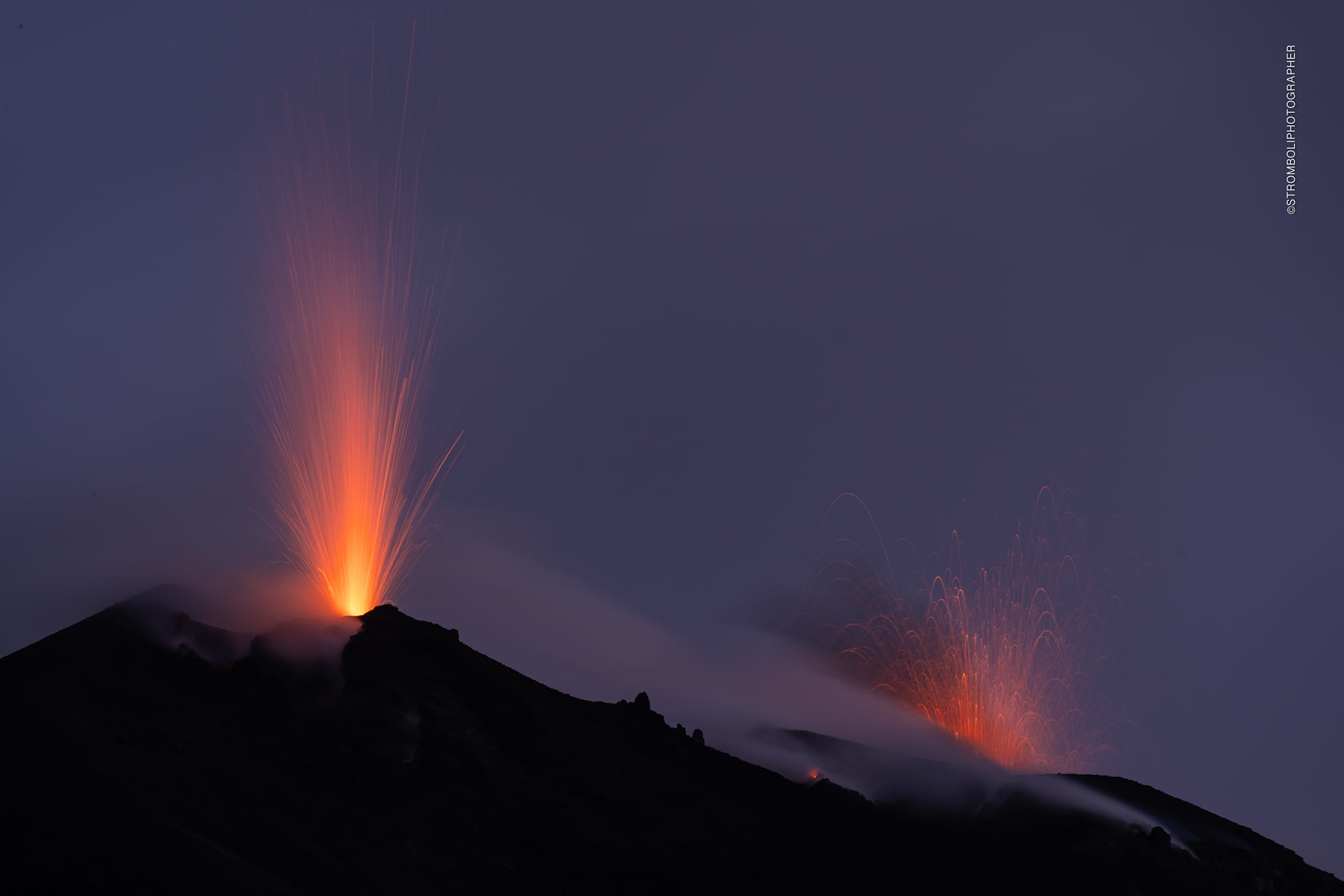
VOLCANOLOGICAL OBSERVATIONS
In the observed period, the eruptive activity of Stromboli was characterized through the analysis of images recorded by the INGV-OE surveillance cameras at altitude 190m (SCT-SCV), from
Pizzo (SPT) and Punta dei Corvi (SPCT). The explosive activity was mainly produced by 3 (three) eruptive vents located in the northern area of the crater and by 2 (two) vents located in the south central area.
Observations of explosive activity captured by surveillance cameras.
In the area of the North crater (N), with two vents located in sector N1 and one in sector N2, explosive activity of low intensity (less than 80 m in height) and medium intensity (less than 150 m) was observed. The products emitted in the eruption were mainly coarse materials (bombs and lapilli). The average frequency of explosions fluctuated between 5 and 6 events/h.
In the South-Central (CS) zone, sectors S1 and C did not show significant activity, while sector S2, with two active vents, showed variable intensity from low to high (more than 150 m height) emitting mixed coarse materials. with ashes. The average frequency of explosions varied between 5 and 9 events/h.
Source : INGV.
Photo : Stromboli stati d’animo / Sebastiano Cannavo.
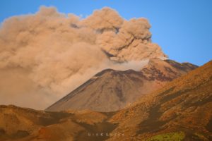
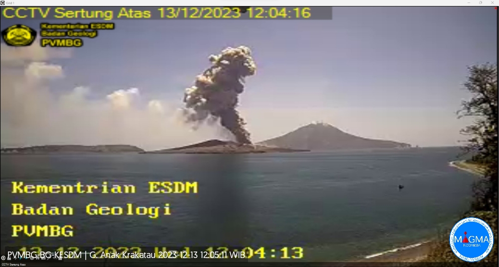
Indonesia , Anak Krakatau :
An eruption of Mount Anak Krakatau occurred on Wednesday, December 13, 2023, at 12:02 WIB. The height of the eruptive column was observed to be ± 600 m above the peak (± 757 m above sea level). The ash column was observed to be gray with moderate intensity, oriented towards the Northeast. The eruption was recorded on a seismograph with a maximum amplitude of 65 mm and a duration of 40 seconds.
VOLCANO OBSERVATORY NOTICE FOR AVIATION – VONA
Issued : December 13 , 2023
Volcano : Anak Krakatau (262000)
Current Aviation Colour Code : ORANGE
Previous Aviation Colour Code : orange
Source : Anak Krakatau Volcano Observatory
Notice Number : 2023KRA130
Volcano Location : S 06 deg 06 min 07 sec E 105 deg 25 min 23 sec
Area : Lampung, Indonesia
Summit Elevation : 502 FT (157 M)
Volcanic Activity Summary :
Eruption with volcanic ash cloud at 05h02 UTC (12h02 local).
Volcanic Cloud Height :
Best estimate of ash-cloud top is around 2422 FT (757 M) above sea level or 1920 FT (600 M) above summit. May be higher than what can be observed clearly. Source of height data: ground observer.
Other Volcanic Cloud Information :
Ash cloud moving to northeast. Volcanic ash is observed to be gray. The intensity of volcanic ash is observed to be medium.
Remarks :
Eruption recorded on seismogram with maximum amplitude 65 mm and maximum duration 40 second.
Source et photo : Magma Indonésie
Iceland , Reykjanes Peninsula :
Land rising faster than before.
Land continues to rise north of Grindavík and at a greater speed than before the seismic swarm that started on November 10. mbl.is/Eggert Jóhannesson
There are still signs of a possible volcanic eruption or other magma-run, such as the one that occurred on November 10, which caused a catastrophe in Grindavík, while magma continues to accumulate under the surface at Svartsengi.
This is stated in a new announcement from the Icelandic Met Office.
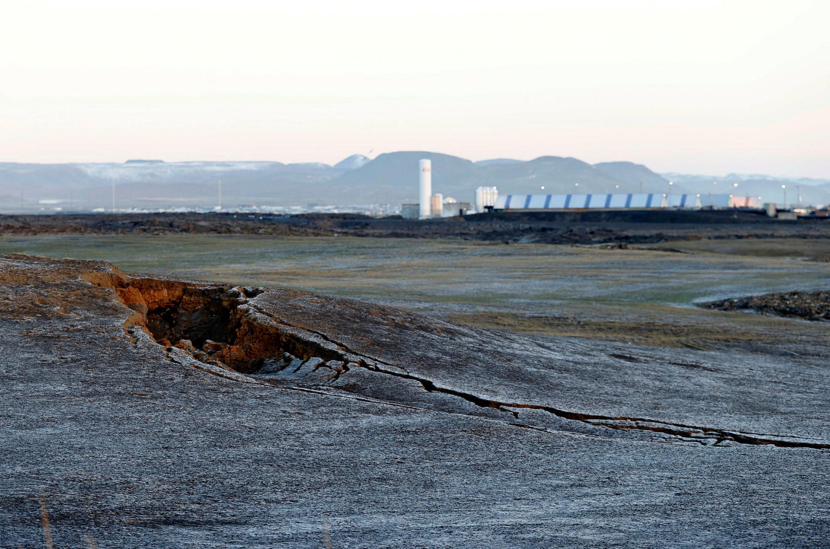
It says that land is continuing to rise beneath Svartsengi, although it has slowed since Friday.
The speed of the land rising is still higher than the speed measured in the days before November 10, when the magma dike under Grindavík was formed.
It is considered most likely that a volcanic eruption would occur north of Grindavík, towards Hagafell and the area around Sundhnúkagígar crater row.
Seismic activity has reportedly remained relatively similar in recent days. Seismic activity is still mild and is most pronounced in the area near Hagafell.
Since midnight, 125 earthquakes have been measured near Grindavík, three of which measured more than 2 in magnitude, the largest of which measured 2,8. All three earthquakes were detected at Hagafell.
Salóme Jórunn Bernharðsdóttir, a natural-hazard specialist at the Icelandic Met Office, tells us that a sustained seismic activity was to be expected along the magma dike, as it is cooling where there is coagulation.
Source : MBL.is
Photo : mbl.is/Eggert Jóhannesson
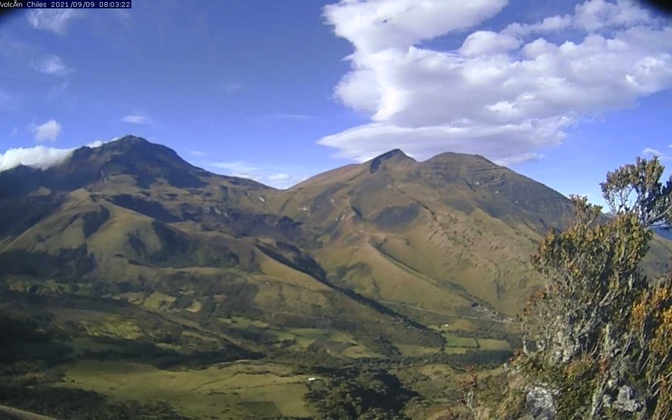
Colombia , Chiles / Cerro Negro :
Weekly activity bulletin from the Chiles and Cerro Negro Volcanic Complex (CVCCN).
Regarding the monitoring of the activity of the CHILES AND CERRO NEGRO VOLCANOES, the MINISTRY OF MINES AND ENERGY, through the COLOMBIAN GEOLOGICAL SERVICE (SGC), reports that:
During the period from December 5 to 11, 2023, and compared to previous weeks, volcanic seismicity showed a significant increase both in terms of occurrence and energy released. The predominance of earthquakes associated with rock fracturing in the volcanic region continued and the recording of events associated with the transit of fluids into the interior of volcanic conduits also continued.
It is worth highlighting the recording of 13 earthquakes associated with rock fracturing with magnitudes greater than 2, three of which were reported as felt by residents of different sectors of the municipality of Cumbal. One of them on December 10 at 3:01 p.m. with M: 2.9, and the other two earthquakes on December 11, at 02:36:20. with a magnitude of 4.4 and at 02:36:58 with a magnitude of 2.7.
The fracturing earthquakes were located mainly to the south of the Chiles volcanic edifice, at distances less than 3.5 km, with depths between 2 and 6 km, compared to the reference height (4700 m above of sea level) and a maximum magnitude of 4.4. Another source of earthquake location occurred southeast of the summit of Chiles Volcano, at distances between 8 and 12 km, with depths between 10 and 13 km from the reference height ( 4,700 m above sea level), and a maximum magnitude of 1.
In addition, they continue deformation processes in different sectors of the CVCCN, recorded by satellite sensors and sensors installed in the field.
The evolution of activity in the CVCCN continues, due to internal processes derived from a complex interaction between the magmatic, hydrothermal system and the geological faults of the area, which is why the probability of occurrence of energetic earthquakes that may be felt by the inhabitants of its area of influence.
Volcanic activity remains on YELLOW ALERT Status: Active volcano with changes in baseline behavior of monitored parameters and other manifestations.
Source et photo : SGC
Ethiopia , Erta Ale :
Erta Ale volcano, Ethiopian Danakil Depression.
The North and South Hornitos recently erupted and released a lot of lava.
Pulsating lava splashes from the large Hornito into the southern Hornito crater on November 21, 2023 and the Saturday image shows a large flow on the northern side of the Hornito.
Another intense effusive phase appeared in the southern crater of the volcano during the last three days.
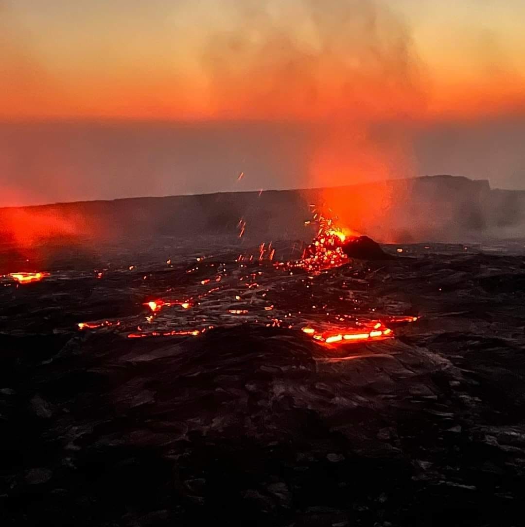
As reported by expedition leader, geologist and local guide Enku Mulugeta of VolcanoDiscovery Ethiopia, a new wave of magma transfer has arrived in the lava lake.
Vigorous lava splashes formed the already large hornito, located on the northwest rim of the crater. This suggests that the flow of magma rising inside the volcano was significant.
The hornito is generally described as a « new volcano » and is considered a Hawaiian-type phenomenon, a volcanic feature forming when a portion of plastic juvenile lava fragments, circulating in a lava tube and/or beneath the surface of A lake of lava escapes and solidifies around the vent. opening due to strong degassing.
It has now been 10 days since the South and North Craters were flooded with emissions of fluid and incandescent lava due to their relatively high discharge rate.
Slabs of dark, solidified crust continue to move across the surface of the pahoehoe-textured lava crust, accompanied by a typical bright orange lava glow.
Source : Ali Nur / Enku Mulugeta.
Photo : Ali Nur