November 08 , 2023.
Italy , Stromboli :
WEEKLY BULLETIN, from October 30, 2023 to November 5, 2023. (issue date November 7, 2023)
SUMMARY STATEMENT OF ACTIVITY
In light of the monitoring data, it appears:
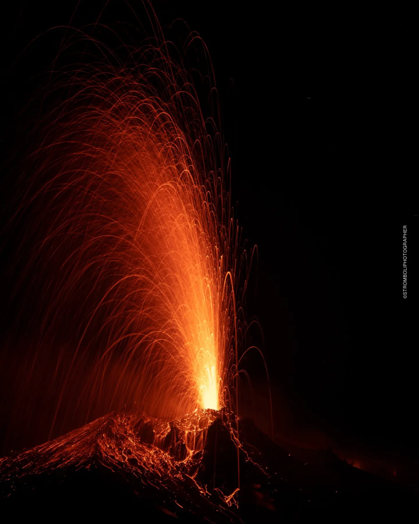
1) VOLCANOLOGICAL OBSERVATIONS: Normal Strombolian activity was observed during this period. The total hourly frequency of explosions fluctuated around average values (8-15 events/hour). The intensity varied from low to medium in the North crater area and from low to high in the South-Central area.
2) SISMOLOGY: The monitored seismological parameters do not show significant variations.
3) GROUND DEFORMATIONS: No significant changes to report
4) GEOCHEMISTRY: SO2 flux at an average and decreasing level.
CO2 flow in the Pizzo area: no update available.
CO2 flux in Scari: daily variability with a slight downward trend.
There is no update on the C/S ratio in the plume.
There is no update on the isotope ratio of dissolved helium in groundwater.
5) SATELLITE OBSERVATIONS: Thermal activity observed by satellite was generally weak.
VOLCANOLOGICAL OBSERVATIONS
In the observed period, the eruptive activity of Stromboli was characterized through the analysis of images recorded by the INGV-OE surveillance cameras at 190 m altitude (SCT and SCV), from Pizzo sopra la Fossa (SPT) and Punta dei Corvi (SPCT). The explosive activity was mainly produced by 2 eruptive chimneys located in the North crater area and by 2 chimneys located in the South-Central crater area.
On October 31, due to unfavorable weather conditions, the visibility of the crater terrace was insufficient for detailed observation of the volcanic phenomena.
Observations of explosive activity captured by surveillance cameras
In correspondence with the area of the North crater (N), characterized by a vent located in sector N1 and one in sector N2, explosive activity of variable intensity ranging from low (the erupting products reached a height less than 80 m) to medium (height less than 150 m). The products emitted in the eruption were mainly coarse materials (bombs and lapilli). The average frequency of explosions fluctuated between 4 and 10 events/hour.
In the South-Central (CS) zone, sectors S1 and C did not show significant activity, while sector S2 showed explosive activity of varying intensity from low to high (height greater than 150 m) with mainly emissions from fine materials mixed with coarse grains. The average frequency of explosions oscillated between 4 and 7 events/hour
Source : INGV.
Photo : Stromboli stati d’animo / sebastiano Cannavo.
Iceland , Reykjanes Peninsula :
Satellite data confirms that uplift continues next to Þorbjörn. Around 900 earthquakes in the area last 24 hours . Updated 7. November at 1:30pm
There have been around 900 earthquakes in the last 24 hours, most of them in the area between Þorbjörn and Sýlingafell. The largest earthquake was M2.9 and occurred around 7 am this morning. The seismic activity remains at the same depth as before.
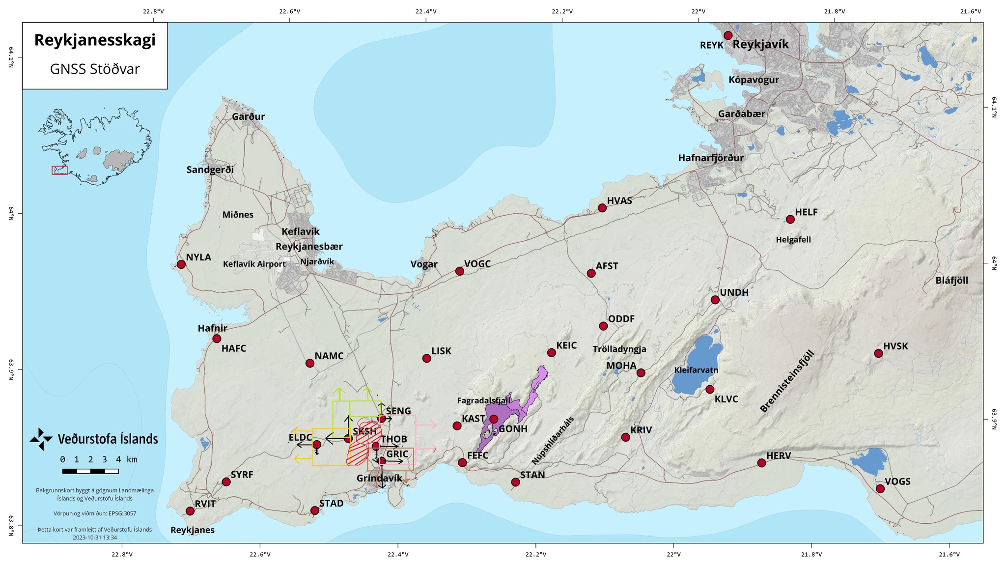
According to satellite data processed around 5 pm yesterday and covers the period between November 4-6, confirms that uplift continues around Þorbjörn. The same data shows no signs of magma accumulation in Eldvörp or near Sýlingafell, east of Svartsengi where seismic activity has been measued in recent days.
Magma accumulation continues at a depth of around 5 km in the are NW of Þorbjörn. If October 27th is considered the starting day of the inflation event until today, the rate of uplift has been fairly constant, although an acceleration of the process has been observed between days. It is likely that seismic activity will continue, and be episodic in intensity, while magma accumulation is ongoing
Source et photo : IMO
Colombia , Chiles / Cerro Negro :
Weekly activity bulletin of the Chiles and Cerro Negro Volcanic Complex (CVCCN)
Regarding the monitoring of the activity of the CHILES AND CERRO NEGRO VOLCANOES, the MINISTRY OF MINES AND ENERGY, through the COLOMBIAN GEOLOGICAL SERVICE (SGC), reports that:
Between October 31 and November 6, 2023, the frequency of earthquakes increased compared to the previous week, but the energy released decreased. Additionally, although the predominance of seismicity associated with rock fracturing in various sectors of the volcanic edifices continues, this week there has been a slight increase in the frequency of fluid dynamics events within the system. volcanic.

Concerning fracture seismicity, the majority of localized earthquakes were located at the source located south of the Chiles volcano, at distances up to 4 km, at depths between 3 and 5 km relative to the height reference (4700 m altitude). A few other earthquakes were located scattered to the West and Southwest of Chiles Volcano, at distances up to 8 km and at depths between 4 and 8 km from the mentioned reference height. The earthquake of November 4 at 1:03 p.m. stands out, with a magnitude of 2.9, which was not reported as felt by residents of the volcanic area.
The sensors installed on these volcanoes and the satellites continue to record deformations in different sectors of the volcanic edifice.
The evolution of activity under the CVCCN continues, due to internal processes derived from a complex interaction between the magmatic, hydrothermal system and the geological faults of the area, which is why the probability of occurrence of earthquakes energetic earth that can be felt is maintained for the inhabitants of the zone of influence of the CVCCN.
Volcanic activity remains on YELLOW ALERT Status: Active volcano with changes in base level behavior of monitored parameters and other manifestations.
Source : SGC
Photo : IGEPN.
Hawaii , Kilauea :
Tuesday, November 7, 2023, 9:05 AM HST (Tuesday, November 7, 2023, 19:05 UTC)
19°25’16 » N 155°17’13 » W,
Summit Elevation 4091 ft (1247 m)
Current Volcano Alert Level: ADVISORY
Current Aviation Color Code: YELLOW
Activity Summary:
Kīlauea volcano is not erupting. The unrest at Kīlauea’s summit has diminished over the past week, with a decrease in seismicity, in association with an intrusive event that began in early October. Unrest may continue to wax and wane with changes to the input of magma into the area. The current rate of uplift at the summit of Kīlauea has also lessened significantly over the last week; however, eruptive activity is still possible in the coming weeks or months. No unusual activity has been noted along Kīlauea’s East Rift Zone or the Southwest Rift Zone.
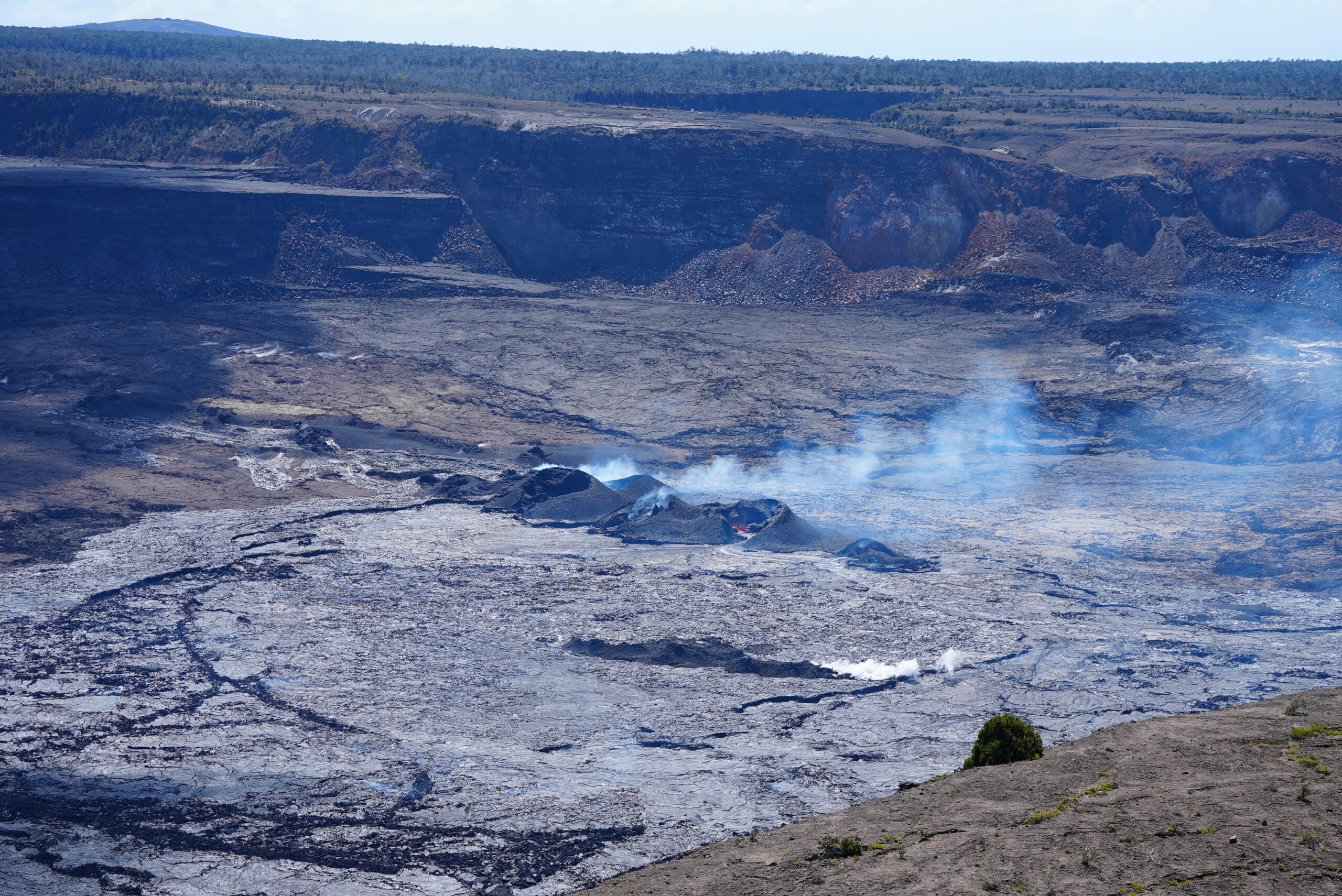
Summit Observations:
Unrest around the summit area of Kīlauea diminished over the past week with a decrease in the level of overall seismicity. Waxing and waning of unrest may continue.
Elevated seismicity associated with an intrusion beneath the south-southwest region of Kīlauea’s summit began in early October with the greatest number of earthquakes occurring on October 4-6, 16-18, 21-23, and 26-30. Over the past 24 hours, seismic activity remained nearly the same, with approximately 3 earthquakes recorded in Kīlauea’s summit region, a slight decrease from approximately 4 over the previous 24 hours. Most of the earthquakes related to this unrest have been smaller than magnitude-2 and have occurred at depths of around 1–3 km (0.6–2 mi) below the surface.
The Uēkahuna summit tiltmeter, located northwest of the caldera, measured slight, gradual uplift over the last 24 hours. The Sand Hill tiltmeter, located southwest of the caldera, also measured slight uplift over the last 24 hours. Overall, the current rate of uplift (as measured by GPS and tiltmeters) at the summit of Kīlauea has diminished significantly over the last week.
Sulfur dioxide (SO2) emission rates remain low and were measured at a rate of about 100 tonnes per day on October 19, 2023.
Source : HVO
Photo : USGS/ M. Patrick. ( archive)
Japan , Iwo Jima :
A small new island has emerged near Iwoto Island, about 1,200 kilometers south of Tokyo, following underwater volcanic eruptions occurring since late last month, according to a Japanese researcher.
Fukashi Maeno, associate professor at the University of Tokyo’s Earthquake Research Institute, said he confirmed phreatomagmatic eruptions took place about 1 km off Iwoto Island in the Pacific and a rocky island with a diameter of around 100 meters as he flew over the site on Oct. 30.
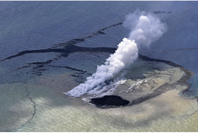
Photo taken from a Kyodo News plane on Oct. 30, 2023, shows a column of steam rising from the waters off Iwoto Island, previously known as Iwojima, in the Pacific Ocean. A new island of 100 meters in diameter, formed by masses of rock spewed from the plumes, is seen near the steam. (Kyodo) ==Kyodo
Plumes rose every several minutes during the eruptions, which resulted from magma and seawater interacting, and possibly reached heights of more than 50 meters, occasionally spewing rocks with diameters of several meters, Maeno said.
Pumice stones were spotted floating in waters around the new island, and nearby seawater changed color as a result of the volcanic activity, Maeno said.
Iwoto Island, previously known as Iwojima, is part of the Ogasawara Islands.
According to the Japanese Meteorological Agency, eruptions have also taken place in the area between July and December 2022, as well as June this year. The agency said it believes the latest eruptions began on Oct. 21.
The eruptions « show the resumption of magmatic activity. The new island is expected to grow larger if the eruptions continue, but the outlook remains uncertain, » Maeno said.
Source et photo : Kyodo news.