November 01 , 2023 .
Iceland , Reykjanes Péninsula :
The series of earthquakes northwest of Þorbjörn this morning is a sign of a magma flow. Situation closely monitored, Updated October 31 at 5 p.m.
This morning, at 8:40 a.m., a seismic swarm started in Þorbjörn, which lasted almost 2 hours and was exceptionally intense. The largest earthquake in the swarm measured M3.7. The center of activity was just east of the center of the uprising observed in recent days. The depth of the earthquakes was estimated between 5 and 1.5 km deep. The seismic swarm is a clear sign of magma movements at depth. GPS measurements confirm this interpretation, although the uprising that began about four days ago has slowed. Earlier today, a meeting was held with Civil Defense and Reykjanes Peninsula stakeholders, during which the latest measures as well as possible scenarios and responses to the current scenario were discussed.

Situation closely monitored
IMO is monitoring closely developments and is looking to see if micro-seismic activity increases closer to the surface, which could be a sign that magma is breaking its way through the earth´s crust. Presently, there are no signs that earthquake activity is becoming shallower. However, the situation could change quickly, and it is not possible to exclude a scenario involving a lava-producing eruption in the area northwest of Þorbjörn. It is important to point out that magma movements, similar to that observed close to Þorbjörn, often fade away and do not lead to a volcanic eruption. Nevertheless, long-term rifting and increased (triggered) earthquake activity in the Svartsengi area could have created weaknesses in the crust, making it easier for magma to move to shallower depths.
Source et photo : IMO
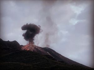
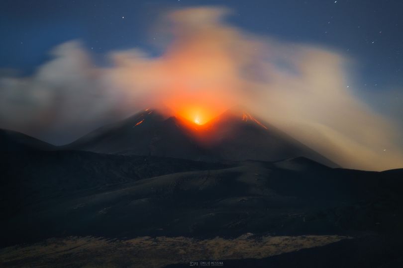
Italy / Sicily , Etna :
MONTHLY BULLETIN, OCTOBER 2023. (issue date October 31, 2023)
SUMMARY STATEMENT OF ACTIVITY
In light of the monitoring data, it appears:
1) VOLCANOLOGICAL OBSERVATIONS: Degassing activity at the Bocca Nuova crater (BN) and Strombolian activity and degassing at the South-East crater (CSE).
2) SEISMOLOGY: moderate seismic activity due to fracturing; average amplitude of volcanic tremor at average levels; sources of tremors in the Southeast crater area
3) INFRASOUND: Moderate infrasound activity, decreasing from the second half of the month. Sources located mainly in the Bocca Nuova crater and, from the 23rd, also in the Southeast crater.
4) GROUND DEFORMATIONS: Over the last month, the ground deformation monitoring networks have not recorded any significant changes.
5) GEOCHEMISTRY: SO2 flux at an average and increasing level.
The CO2 flux from the soil remains low.
The partial pressure of CO2 dissolved in groundwater presents values included in seasonal variability.
The helium isotope ratio in the peripheral areas is average.
6) SATELLITE OBSERVATIONS: Thermal activity observed by satellite was generally low level with rare and isolated anomalies of moderate level.
VOLCANOLOGICAL OBSERVATIONS
During the reference period, monitoring of the volcanic activity of Etna was carried out through the analysis of images from the surveillance cameras of the INGV, Osservatorio Etneo (INGV-OE) and through inspections in the summit area carried out by INGV-OE staff. Observations were sometimes made difficult and discontinuous due to the cloud cover which sometimes affected the summit area.
The period was characterized by degassing activity at the Bocca Nuova crater (BN) and by Strombolian activity and degassing at the Southeast crater (CSE).
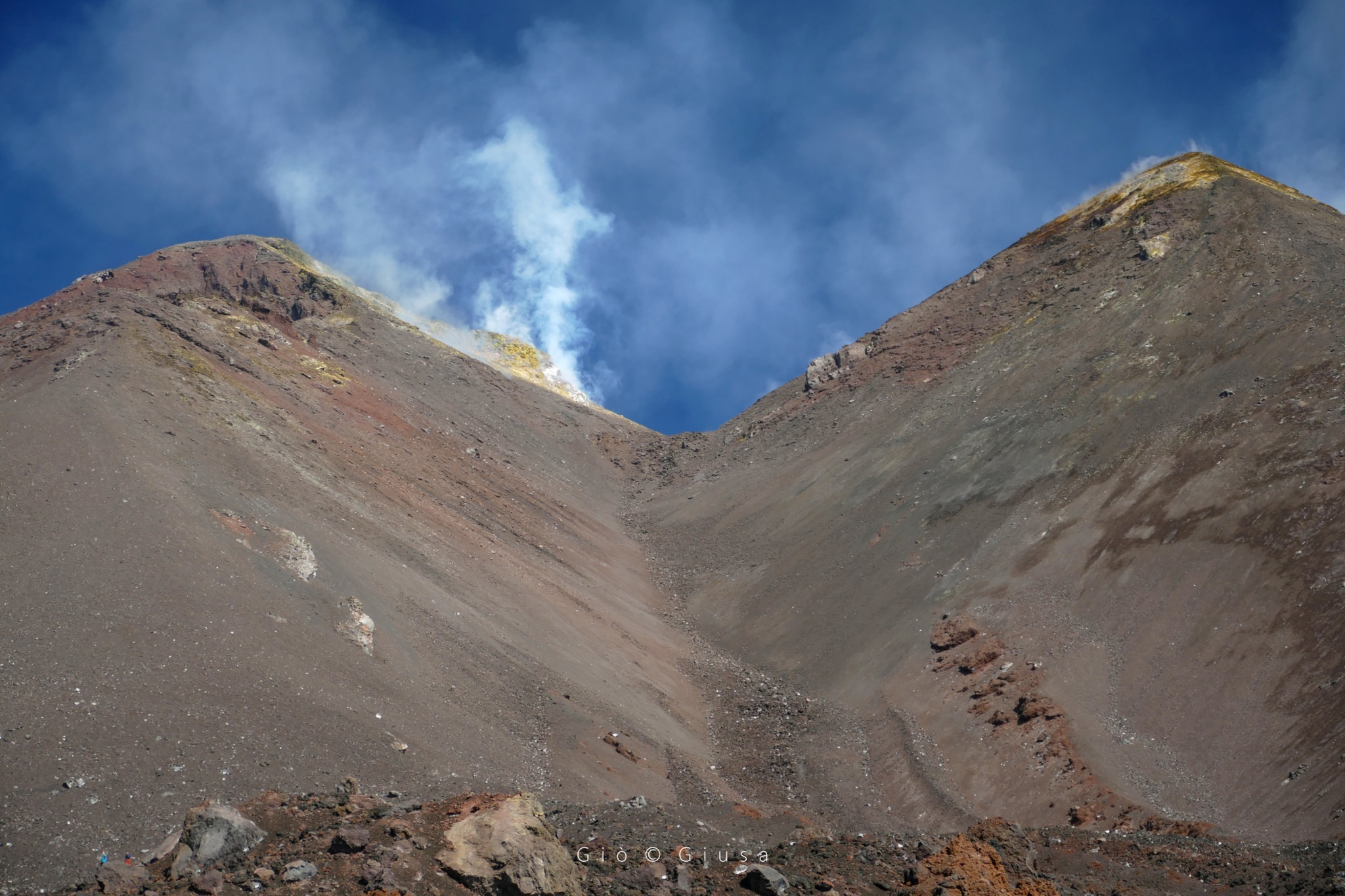
In particular, with regard to the Southeast Crater (CSE), widespread degassing continued from the summit zone and the upper part of the fracture present on the Southwest flank of the crater, corresponding to the ancient cone of the Southeast crater.
Since October 9, nocturnal glows and weak, discontinuous Strombolian explosions have been observed, sometimes accompanied by weak emissions of ash quickly dispersed in the atmosphere in the summit area. The frequency and intensity of this Strombolian activity gradually intensified in the second part of the observation period, although it remained essentially discontinuous. In most cases, the material produced remains inside the cone while sometimes falling along its edges or sides.
This Strombolian activity led to the formation of a small pyroclastic cone within the Southeast Crater (SEC), which gradually developed after October 22.
Regarding the Bocca Nuova (BN) crater, we observe continuous degassing, of variable intensity from the BN-1 vent and pulsating from the BN-2 vent, accompanied by frequent intense flashes. clearly visible during the night.
Finally, the Northeast crater (CNE) still remains obstructed and affected by weak degassing coming from a fumarolic zone along the northwest inner wall, while the Voragine crater (VOR) still remains obstructed and no type of degassing was observed.
Source : INGV.
Photo : Emilio Messina Photography , Gio Giusa .
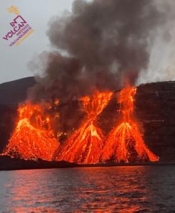
Italy , Stromboli :
WEEKLY BULLETIN, from October 23, 2023 to October 29, 2023. (issue date October 31, 2023)
SUMMARY STATEMENT OF ACTIVITY
In light of the monitoring data, it appears:
1) VOLCANOLOGICAL OBSERVATIONS: Normal Strombolian activity was observed during this period. The total hourly frequency fluctuated between average values (8-12 events/h). The intensity of the explosions varied from low to medium in the North crater area and from low to high in the South-Central area.
2) SISMOLOGY: The monitored seismological parameters do not show significant variations.
3) GROUND DEFORMATIONS: The island’s ground deformation monitoring networks did not show significant variations during the period studied.
4) GEOCHEMISTRY: SO2 flux at an average and decreasing level.
CO2 flow in the Pizzo area: no update available.
CO2 flow at Scari: almost stable at high values.
There is no update on the C/S ratio in the plume.
There is no update on the isotope ratio of dissolved helium in groundwater.
5) SATELLITE OBSERVATIONS: Thermal activity observed by satellite was generally weak.
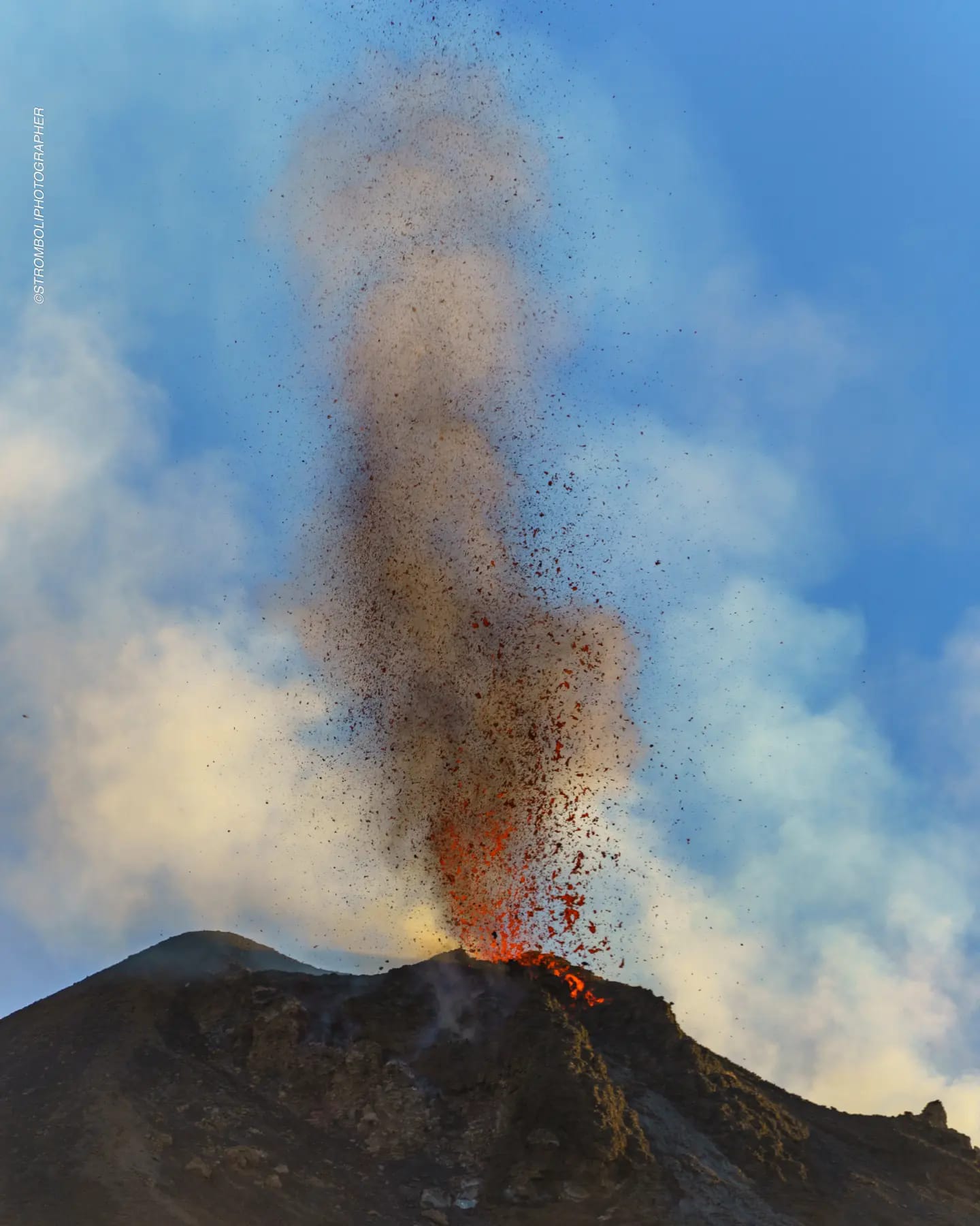
VOLCANOLOGICAL OBSERVATIONS
In the observed period, the eruptive activity of Stromboli was characterized through the analysis of images recorded by the INGV-OE surveillance cameras at altitude 190m (SCT-SCV), from
Pizzo and Punta dei Corvi. The explosive activity was mainly produced by 4 (four) eruptive chimneys located in the northern zone of the crater and by 3 (three) chimneys located in the South Central zone.
Due to unfavorable weather conditions, visibility of the crater terrace was insufficient on October 26.
Observations of explosive activity captured by surveillance cameras
In the area of the North crater (N), with two vents located in sector N1 and one in sector N2, explosive activity of varying intensity from low (less than 80 m high) to medium (less than 150 m high). top) was observed. The products of the eruption consisted mainly of coarse materials (bombs and lapilli).
The average frequency of explosions fluctuated between 3 and 5 events/h.
In the South-Central (CS) zone, sectors S1 and C did not show significant activity while sector S2 showed explosive activity of varying intensity from low to high (more than 150 m in height), with emission of mainly fine material mixed with coarse materials. The average frequency of explosions fluctuated between 4 and 7 events/h.
Source : INGV
Photo : Stromboli stati d’animo
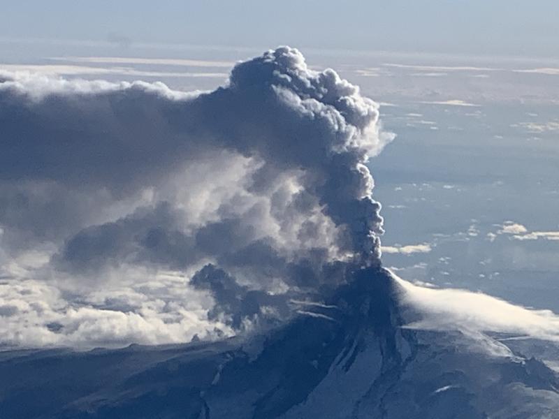
Alaska , Shishaldin :
AVO/USGS Volcanic Activity Notice
Current Volcano Alert Level: ADVISORY
Previous Volcano Alert Level: WATCH
Current Aviation Color Code: YELLOW
Previous Aviation Color Code: ORANGE
Issued: Tuesday, October 31, 2023, 12:51 PM AKDT
Source: Alaska Volcano Observatory
Notice Number: 2023/A1562
Location: N 54 deg 45 min W 163 deg 58 min
Elevation: 9373 ft (2857 m)
Area: Aleutians
Volcanic Activity Summary:
Volcanic activity at Shishaldin Volcano has decreased over the past few weeks. While current seismicity consisting of low-level tremor and small low frequency earthquakes continues above background levels, there have been no large ash-producing explosions at the volcano since October 3, 2023. Recent satellite observations also show a decrease in surface temperatures and a decline in sulfur dioxide emissions. Due to this decrease in activity, the Alaska Volcano Observatory is lowering the Aviation Color Code for Shishaldin Volcano to YELLOW and the Alert Level to ADVISORY.
The recent episode of activity at Shishaldin began on July 11, 2023 with the observation of strongly elevated surface temperatures at the summit in satellite data and increasing seismic activity. A significant explosion was observed on July 14 2023 that produced an ash cloud to over 30,000 ft. Eleven more significant explosions followed over the next 3 months with the last explosive eruption occurring on Oct. 3, 2023. Additional ash-producing explosive eruptions are possible and would likely be preceded by increases in seismic tremor and elevated surface temperatures.
Shishaldin Volcano is monitored by local seismic and infrasound sensors, web cameras, and a telemetered geodetic network. In addition to the local monitoring network, AVO uses nearby geophysical networks, regional infrasound and lighting data, and satellite images to detect eruptions.
Source : AVO
Photo : Woodsen Saunders , AVO.
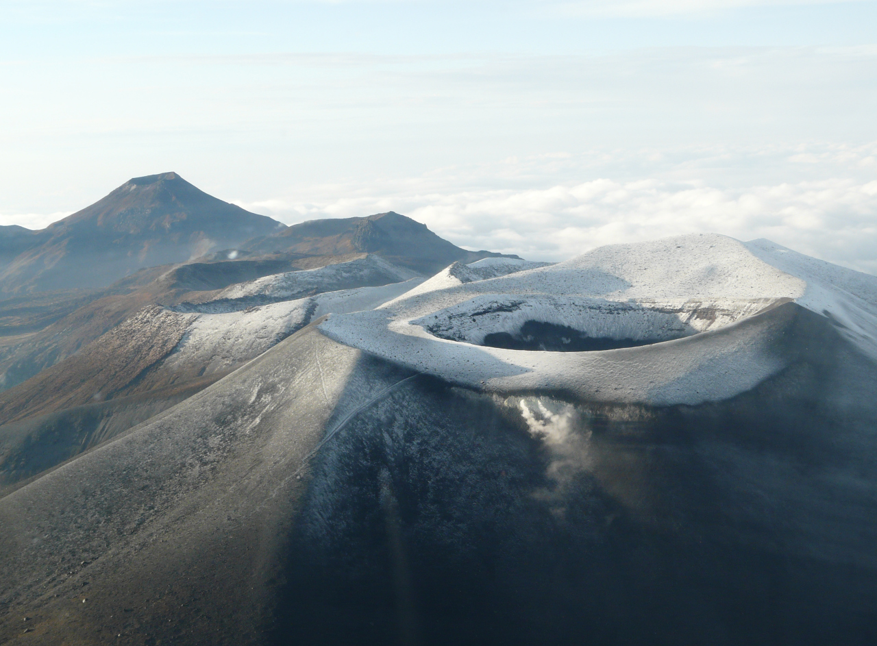
Colombia , Puracé – Los Coconucos Volcanic Range :
Weekly bulletin of the activity of the Puracé volcano – Los Coconucos volcanic chain
Monitoring the activity of the PURACE VOLCANO – LOS COCONUCOS VOLCANIC CHAIN, the MINISTRY OF MINES AND ENERGY through the COLOMBIAN GEOLOGICAL SERVICE (SGC)
reports:
During the week of October 24 to 30, 2023, seismic activity increased in the number of earthquakes recorded between days 24 and 28 compared to what was observed in previous weeks.
The frequency of events associated with rock fracturing has increased, with a predominant location between the southeastern flank of the Puracé volcano and the edifices of the Piocollo and Curiquinga volcanoes, with depths of between 1.5 and 4 km. However, the energy released and the magnitudes calculated were low.
Seismic events linked to the movement of fluids in volcanic conduits have also occurred, located mainly under the crater of the Puracé volcano. This activity was accompanied by localized deformations in the upper part of the volcanic chain. In addition, stable values were recorded in the flow of sulfur dioxide (SO2) and high values in the concentration of carbon dioxide (CO2) persist, compared to what was recorded in the first half of 2023.
The images obtained using the installed cameras show the degassing of the volcanic system.
The other parameters measured and used for the diagnosis of volcanic activity showed no notable changes during the period evaluated.
The alert status for volcanic activity remains at: YELLOW ALERT: ACTIVE VOLCANO WITH CHANGES IN THE BEHAVIOR OF THE BASE LEVEL OF MONITORED PARAMETERS AND OTHER MANIFESTATIONS.
Source et photo : SGC
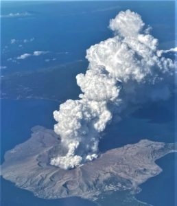
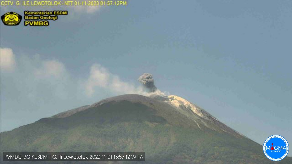
Indonesia , Ili Lewotolok :
The eruption of Mount Ili Lewotolok occurred on Wednesday, November 1, 2023 at 1:57 p.m. WITA with the height of the ash column observed at ± 300 m above the summit (± 1723 m above sea level) . The ash column was observed to be gray with thick intensity, oriented towards the West and Northwest. This eruption was recorded on a seismograph with a maximum amplitude of 8 mm and a duration of 42 seconds.
VOLCANO OBSERVATORY NOTICE FOR AVIATION – VONA
Issued : November 01 , 2023.
Volcano : Ili Lewotolok (264230)
Current Aviation Colour Code : ORANGE
Previous Aviation Colour Code : orange
Source : Ili Lewotolok Volcano Observatory
Notice Number : 2023LEW084
Volcano Location : S 08 deg 16 min 19 sec E 123 deg 30 min 18 sec
Area : East Nusa Tenggara, Indonesia
Summit Elevation : 4554 FT (1423 M)
Volcanic Activity Summary :
Eruption with volcanic ash cloud at 05h57 UTC (13h57 local).
Volcanic Cloud Height :
Best estimate of ash-cloud top is around 5514 FT (1723 M) above sea level or 960 FT (300 M) above summit. May be higher than what can be observed clearly. Source of height data: ground observer.
Other Volcanic Cloud Information :
Ash cloud moving from west to northwest. Volcanic ash is observed to be gray. The intensity of volcanic ash is observed to be thick.
Remarks :
Eruption recorded on seismogram with maximum amplitude 8 mm and maximum duration 42 second.
Source : Magma Indonésie.