October 27 , 2023
Alaska , Aniakchak :
Thursday, October 26, 2023, 2:07 PM AKDT (Thursday, October 26, 2023, 22:07 UTC)
56°54’21 » N 158°12’32 » W,
Summit Elevation 4400 ft (1341 m)
Current Volcano Alert Level: NORMAL
Current Aviation Color Code: GREEN
Strong winds blowing to the northwest in the region northwest of Aniakchak and east of Port Heiden have picked up loose volcanic ash and carried it to the northwest today. A cloud of resuspended volcanic ash is visible in satellite data and web camera views from Port Heiden. The National Weather Service has issued a SIGMET for this low-level event and suggests that the maximum cloud height is 3,000 ft (0.9 km) above sea level.
This phenomenon is not the result of volcanic activity and usually occurs seasonally in the spring and fall during times of high winds and dry, snow-free conditions in volcanic areas of Alaska. No eruption is in progress. Aniakchak remains at color code GREEN. Resuspended volcanic ash should be considered hazardous and could be damaging to aircraft and health.
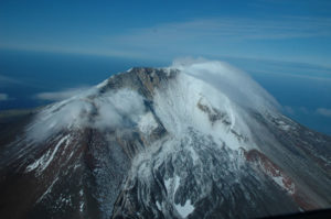
Aniakchak volcano, located in the central portion of the Alaska Peninsula, consists of a stratovolcano edifice with a 6 mile (10 km) diameter summit caldera. The caldera-forming eruption occurred around 3,500 years ago. Post-caldera eruptions have produced lava domes, tuff cones, and larger spatter and scoria cone structures, including Half-Cone and Vent Mountain, all within the caldera. The most recent eruption occurred in 1931 and created a new vent and lava flows on the western caldera floor while spreading ash over much of southwestern Alaska. Aniakchak volcano is 16 miles (26 km) southeast of the nearest community, Port Heiden, and 416 miles (670 km) southwest of Anchorage, Alaska.
Source : AVO
Photo : Mayo, Wyatt / Alaska Volcano Observatory / Alaska Division of Geological & Geophysical Surveys
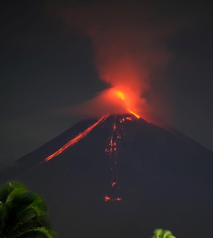
Kamchatka , Klyuchevskoy :
VOLCANO OBSERVATORY NOTICE FOR AVIATION (VONA)
Issued: October 27 , 2023
Volcano: Klyuchevskoy (CAVW #300260)
Current aviation colour code: ORANGE
Previous aviation colour code: orange
Source: KVERT
Notice Number: 2023-128
Volcano Location: N 56 deg 3 min E 160 deg 38 min
Area: Kamchatka, Russia
Summit Elevation: 4750 m (15580 ft)
Volcanic Activity Summary:
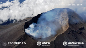
The summit explosive-effusive eruption of the volcano continues. Against the background of explosive activity of the Strombolian type (lava fountaining in the volcanic crater up to 500 m), the lava flows continue to effuse alternately along the Apakhonchichsky and Kozyrevsky chutes on the southern slopes of the volcano. Satellite data by KVERT showed an ash plume is extending for 280 km to the southeast of the volcano.
The summit explosive-effusive eruption of the volcano continues. Ash explosions up to 7-8 km (23,000-26,200 ft) a.s.l. could occur at any time. Ongoing activity could affect international and low-flying aircraft.
Volcanic cloud height:
5000-5500 m (16400-18040 ft) AMSL Time and method of ash plume/cloud height determination: 20231027/0116Z – Video data
Other volcanic cloud information:
Distance of ash plume/cloud of the volcano: 280 km (174 mi)
Direction of drift of ash plume/cloud of the volcano: SE / azimuth 136 deg
Time and method of ash plume/cloud determination: 20231027/0040Z – Himawari-9 14m15
Source : KVERT
Photo : Andrew Matseevsky
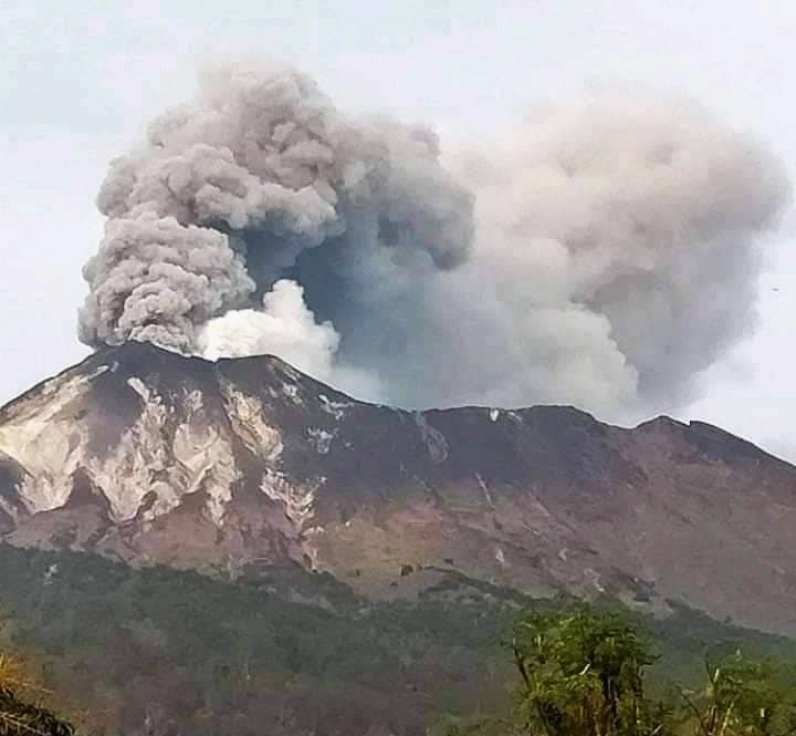
Indonesia , Ili Lewotolok :
Mount Ili Lewotolok erupted on Friday, October 27, 2023, at 05:12 WITA. The height of the eruptive column was observed to be ±500 m above the peak (±1923 m above sea level). The ash column was observed to be gray with thick intensity, oriented towards the West. The eruption was recorded on a seismograph with a maximum amplitude of 16.8 mm and a duration of 120 seconds.
VOLCANO OBSERVATORY NOTICE FOR AVIATION – VONA
Issued : October 26 , 2023.
Volcano : Ili Lewotolok (264230)
Current Aviation Colour Code : ORANGE
Previous Aviation Colour Code : orange
Source : Ili Lewotolok Volcano Observatory
Notice Number : 2023LEW082
Volcano Location : S 08 deg 16 min 19 sec E 123 deg 30 min 18 sec
Area : East Nusa Tenggara, Indonesia
Summit Elevation : 4554 FT (1423 M)
Volcanic Activity Summary :
Eruption with volcanic ash cloud at 21h12 UTC (05h12 local).
Volcanic Cloud Height :
Best estimate of ash-cloud top is around 5834 FT (1823 M) above sea level or 1280 FT (400 M) above summit. May be higher than what can be observed clearly. Source of height data: ground observer.
Other Volcanic Cloud Information :
Ash cloud moving to west. Volcanic ash is observed to be gray. The intensity of volcanic ash is observed to be thick.
Remarks :
Eruption recorded on seismogram with maximum amplitude 16.8 mm and maximum duration 120 second.
Source : Magma Indonésie.
Photo : Kodi Setiawan
Iceland , Reykjanes Peninsula :
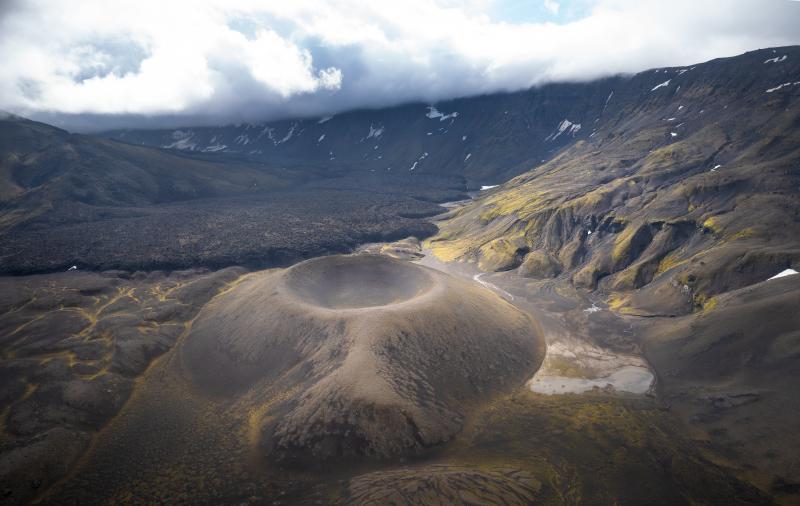
Triggered earthquake activity north of Grindavík . No deformation measured nearby Svartsengi and Grindavík. 25.10.2023
Updated: 26th of October at 5pm
The seismic swarm that commenced on 24 October continues. Over 4,000 earthquakes have been recorded on the Reykjanes Peninsula, of which 14 had a magnitude exceeding M3. Most of the activity has occurred between Stóra-Skogafell and North-East of Eldvörp. Seismicity is located between 2 and 6 km depth, with the largest earthquake (M4.5) measured on 25 October at 08:18 UTC. Scientists at the Icelandic Meteorological Office (IMO) interpret the ongoing seismic activity as triggered by stress induced by the ongoing deformation at Fagradalsfjall, which began soon after the summer 2023 eruption. The ongoing seismic swarm is expected to continue for the coming days. In the longer-term, the continued accumulation of magma beneath Fagradalsfjall could cause further seismic swarms on the peninsula.
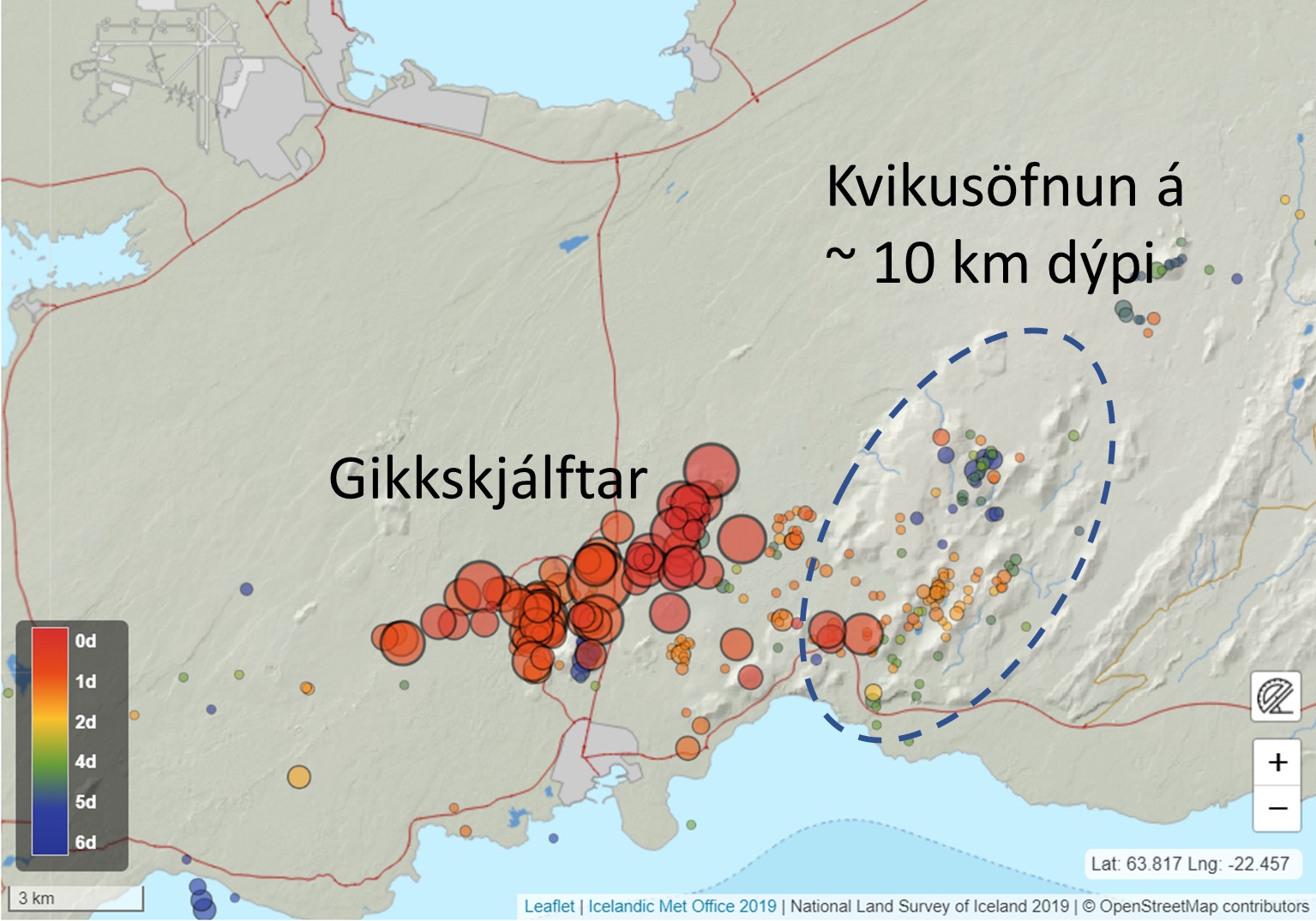
Ground deformation measurements near Svartsengi and Grindavík show no changes related to the ongoing seismic swarm north of Grindavík. A single GPS station (FEFC), east of Festarfjall, is beginning to show localised movement in a south-east direction. These measurements could indicate the presence of magma at depth along the continuation of north-east – south-west-trending dyke intrusions, which have formed under Fagradalsfjall since 2021.
Staff from IMO continue to monitor the seismic unrest closely. In the coming days, satellite data will be used to better assess the spatial extent of any ground deformation. The measurements will also be used to better understand ongoing geophysical processes on the Reykjanes Peninsula.
Source et photo : IMO
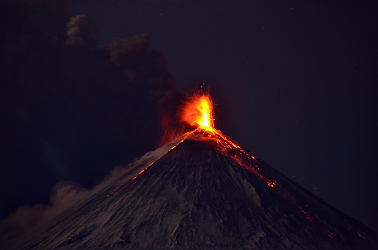
Philippines , Mayon :
MAYON VOLCANO BULLETIN 27 October 2023 8:00 AM
In the past 24-hour period, the Mayon Volcano Network recorded ninety-nine (99) volcanic earthquakes including ninety-three (93) volcanic tremors having a duration of one (1) to thirty-eight (38) minutes, three (3) pyroclastic density current events, and two hundred nineteen (219) rockfall events. The lava flows have maintained their advances to approximately 3.4 kilometers in Bonga (southeastern), 2.8 kilometers in Mi-isi (south), and 1.1 kilometers in Basud (eastern) Gullies. Rockfalls and PDCs generated by the collapse of the summit dome deposited debris still within four (4) kilometers of the crater
Volcanic sulfur dioxide (SO2) emission averaged 1,030 tonnes/day on 26 October 2023. Short-term observations from electronic tilt and GPS monitoring indicate inflation of the northwestern upper and middle slopes since late July 2023 and October 2023, respectively. Longer-term ground deformation parameters from EDM, precise leveling, continuous GPS, and electronic tilt monitoring indicate that Mayon is still generally inflated relative to baseline levels.
Alert Level 3 is maintained over Mayon Volcano, which means that it is currently in a relatively high level of unrest, and hazardous eruption within weeks or even days could still be possible.
Source : Phivolcs.
Photo : Dex Baldon