October 20 , 2023.
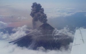
Alaska , Shishaldin :
54°45’19 » N 163°58’16 » W,
Summit Elevation 9373 ft (2857 m)
Current Volcano Alert Level: WATCH
Current Aviation Color Code: ORANGE
Volcanic unrest continues at Shishaldin Volcano. Seismic activity remains elevated and consists of seismic tremor and small, low-frequency earthquakes. Sulfur dioxide gas emissions were seen again in satellite data yesterday. Elevated surface temperatures were evident in satellite images throughout the past day; however, thermal output is not consistent with new lava at the surface. Instead, a high-resolution satellite image from October 16 shows a linear feature that extends a few hundred meters from the summit down the northeast flank that is the source of intense steaming. These observations are all consistent with magma degassing at fairly shallow levels beneath the volcano.
Twelve significant explosive events have occurred at Shishaldin since July 12, 2023. These events have been preceded by increases in seismicity in the hours to days before they occur. It is unknown how long this period of ongoing activity will last. However, previous eruptions of Shishaldin Volcano have lasted weeks to months with repeated cycles of eruptive activity like those seen since July.
Local seismic and infrasound sensors, web cameras, and a geodetic network monitor Shishaldin Volcano. In addition to the local monitoring network, AVO uses nearby geophysical networks, regional infrasound and lighting data, and satellite images to detect eruptions.
Source : AVO
Photo : Nick Enloe
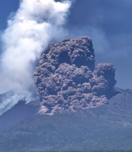
Kamchatka , Bezymianny :
VOLCANO OBSERVATORY NOTICE FOR AVIATION (VONA)
Issued: October 18 , 2023.
Volcano: Bezymianny (CAVW #300250)
Current aviation colour code: ORANGE
Previous aviation colour code: red
Source: KVERT
Notice Number: 2023-118
Volcano Location: N 55 deg 58 min E 160 deg 35 min
Area: Kamchatka, Russia
Summit Elevation: 2882 m (9452.96 ft)
Volcanic Activity Summary:
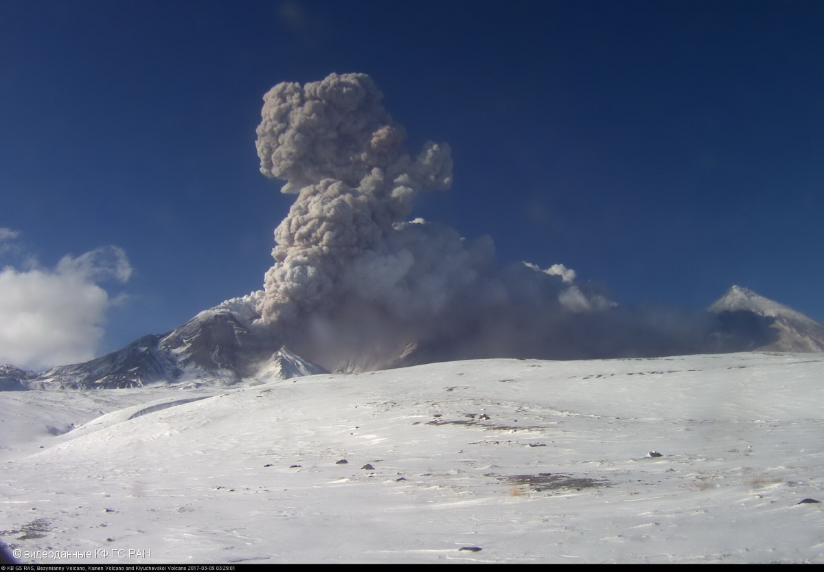
The paroxysmal explosive eruption of the Bezymianny volcano has ended. However, a long ash cloud 250×70 km in size continues to move north-northeast from the volcano at an altitude of approximately 8 km a.s.l. At 08:30 UTC on 18 October, the northern edge of the ash cloud was located 268 km north-northeast of the volcano.
The eruptive cloud continues to move north-northeast from the volcano at an altitude of 8 km a.s.l. Ongoing activity could affect international and low-flying aircraft.
Volcanic cloud height:
NO ASH CLOUD PRODUSED
Other volcanic cloud information:
NO ASH CLOUD PRODUSED
Source : Kvert
Photo : Archive videodata KB GS RAS ( 2017)
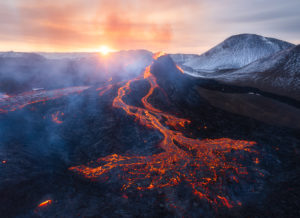
Colombia , Nevado del Ruiz :
Weekly bulletin on the activity of the Nevado del Ruiz volcano
From the monitoring of the activity of the NEVADO DEL RUIZ VOLCANO, the MINISTRY OF MINES AND ENERGY through the COLOMBIAN GEOLOGICAL SERVICE (SGC) reports that:
In the week of October 10 to 17, 2023, the volcano continued to exhibit instability in its behavior, with low to moderate activity levels. Compared to
The previous week, the main variations in the parameters monitored were:
– Seismicity linked to fluid dynamics inside volcanic conduits has increased in the number of earthquakes recorded and in the seismic energy released. Most of these seismic signals had low to sometimes moderate energy levels and were primarily associated with pulsatile emissions of ash and gas into the atmosphere. Additionally, several significant changes in the relative temperature of the emitted material, as well as incandescence, were observed. These phenomena were confirmed thanks to the cameras used to monitor the volcano.
– Seismic activity associated with the fracturing of rocks within the volcanic edifice increased in the number of recorded earthquakes and remained at similar levels in the seismic energy released.
The earthquakes were located in the Arenas crater and on the northeast and southwest flanks of the volcano. The depths of the earthquakes varied between less than 1 and 5 km, relative to the summit of the volcano. The maximum magnitude recorded was 1.5, corresponding to the earthquake recorded on October 15, at 4:48 a.m., located 1.5 km north-northeast of the Arenas crater at 3.8 km depth. Note, between October 14 and 16, the recording of several episodes of seismicity linked to the activity of the lava dome (protuberance or mound) located at the bottom of the
crater. These episodes were low energy levels and short in duration.
– On the volcano, emissions of water vapor and gases into the atmosphere continued with rates of sulfur dioxide (SO2) degassing slightly lower than those of the previous week. The maximum vertical and dispersion height of the gas and ash column was 2,000 m. These values were measured at the summit of the volcano, on October 13 and 16, respectively. The direction of dispersion of the column was variable with a preferential trend towards the North-West. This trend has generated ash falls, on several occasions, in the Tumbas Valley sector of the Los Nevados National Natural Park.
– When monitoring surface activity from satellite monitoring platforms, several reports of thermal anomalies of moderate energy level detected at the bottom of the crater were obtained, notably on October 12 and 13. On October 12, one of these reports exceeded the maximum value detected since monitoring of this parameter (2007). The highest values of thermal anomalies were observed in 2015, during the process of exiting the lava dome into the crater; in 2017, linked to the growth of this same dome; and in April this year, when the volcano was on orange alert (previously active level).
– In addition, the lava dome was observed from satellite images and the flyby carried out by the Colombian Aerospace Force (FAC). The lava dome does not show significant changes in its geomorphology and appearance, but it does exhibit surface temperatures above 340°C.
Source et photo : SGC
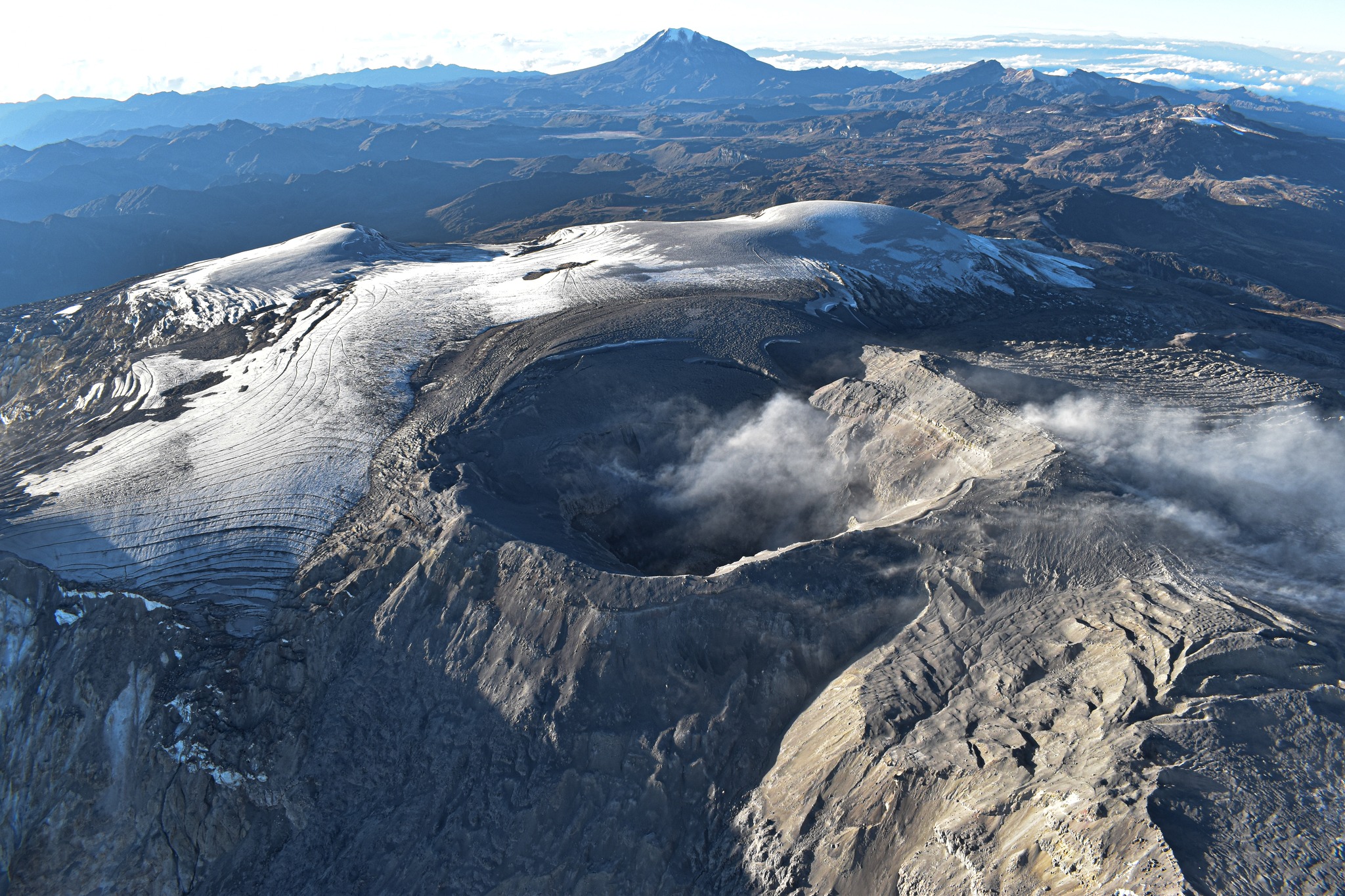
Hawaii , Kilauea :
Wednesday, October 18, 2023, 9:54 AM HST (Wednesday, October 18, 2023, 19:54 UTC)
19°25’16 » N 155°17’13 » W,
Summit Elevation 4091 ft (1247 m)
Current Volcano Alert Level: ADVISORY
Current Aviation Color Code: YELLOW
Activity Summary:
Kīlauea volcano is not erupting. The area south-southwest of Kīlauea’s summit continues to show signs of episodic unrest as the intrusive event that began in early October continues intermittently at a lower rate. The unrest is expected to continue to wax and wane with changes of input of magma in the area. The summit of Kīlauea remains at a high level of inflation and eruptive activity is possible in the coming weeks or months. No unusual activity has been noted along Kīlauea’s East Rift Zone or the Southwest Rift Zone.
Summit Observations:
Episodic unrest continues south and southwest of the summit area of Kīlauea. Overall, inflation at the summit of Kīlauea remains high and has surpassed the level seen just before the most recent eruption on September 10th. However, the current rate of inflation in the region have diminished significantly since October 4-6. Waxing and waning of the unrest is expected as this event continues at lower levels of unrest.
Renewed seismicity began on October 16 and continues to be recorded beneath the south end of Kīlauea caldera extending to the southwest along the trend of December 1974 vents. The renewed activity peaked on October 17 and has been slowly decreasing since then.Over the past 24 hours, approximately 86 earthquakes were recorded in Kīlauea summit region. Most of the earthquakes from the seismic swarm south of the caldera are at depths of around 1–3 km (0.6–2 mi) below the surface.

The Uēkahuna summit tiltmeter located north of the caldera recorded remained flat over the past 24 hours. The Sand Hill tiltmeter, located just southwest of the caldera, is showing continued inflation but the inflation rate dropped significantly overnight. GPS units within the south end of the caldera and further south and west have shown little uplift of this region since October 11, when the seismicity dropped abruptly.
Sulfur dioxide (SO2) emission rates remain low and were measured at a rate of about 100 tonnes per day on October 6.
It is unclear how long the current unrest in Kīlauea summit region will continue. At this time, it is not possible to say with certainty if this activity will lead to an eruption; the activity may remain below the ground surface. However, an eruption remains possible, most likely in Kīlauea’s summit region inside of Hawai‘i Volcanoes National Park and away from infrastructure. Similar patterns of earthquake activity and ground deformation occurred to the south of the caldera prior to the September and June 2023 eruptions in Kīlauea summit caldera (in Halemaʻumaʻu crater and on the downdropped block). Volcanic gas emissions pose the greatest hazard to areas downwind of Kīlauea’s summit.
Although unrest in Kīlauea summit region continues, there is currently no sign of an imminent eruption and increasing inflation and earthquake activity (heightened unrest) are expected to precede an eruption. During periods of heightened unrest prior to recent eruptions at Kīlauea summit, signs of imminent eruption did not appear until 1-2 hours before lava reached the surface. The summit of Kīlauea remains at a high level of inflation and eruptive activity is possible in the coming weeks or months. HVO scientists will continue to monitor Kīlauea volcano closely and will issue additional messages as warranted by changing activity.
Source : HVO
Photo : USGS/ M. Zoeller.
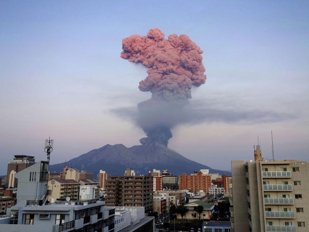
Japan , Sakurajima :
JMA reported ongoing activity at Minamidake Crater (Aira Caldera’s Sakurajima volcano) during 9-16 October, with incandescence at the crater observed nightly. During the week there were a total of 18 eruptive events and 18 explosions. Ash plumes rose as high as 2.6 km above the crater rim and large blocks were ejected 800-900 m from the vent. The Alert Level remained at 3 (on a 5-level scale), and the public was warned to stay 2 km away from both craters.
The Aira caldera in the northern half of Kagoshima Bay contains the post-caldera Sakurajima volcano, one of Japan’s most active. Eruption of the voluminous Ito pyroclastic flow accompanied formation of the 17 x 23 km caldera about 22,000 years ago. The smaller Wakamiko caldera was formed during the early Holocene in the NE corner of the caldera, along with several post-caldera cones. The construction of Sakurajima began about 13,000 years ago on the southern rim and built an island that was joined to the Osumi Peninsula during the major explosive and effusive eruption of 1914. Activity at the Kitadake summit cone ended about 4,850 years ago, after which eruptions took place at Minamidake. Frequent eruptions since the 8th century have deposited ash on the city of Kagoshima, located across Kagoshima Bay only 8 km from the summit. The largest recorded eruption took place during 1471-76.
Source :Japan Meteorological Agency (JMA) , GVP.
Photo : Deniss García Mendoza
Kipuka n° 3
Issue 3 of kīpuka, a popular science magazine devoted to volcanoes, has just been published! Contents of this issue: eruptive and scientific news from the past quarter, the story of a mysterious Pakistani eruption, a historical article on debris avalanches…
The “Life” section focuses on the strange organisms that inhabit hydrothermal vents, while the quarterly file looks at the numerous interactions that link volcanism and climate. Everything is available in single copies or by annual subscription, in paper or digital version. More information on: https://www.kipuka.fr
Source : Jean Marie Prival.