October 12 , 2023.
Japan , Nishinoshima :
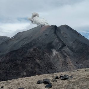
A small eruption at Nishinoshima’s central crater was observed during an overflight conducted by the Japan Coast Guard on 4 October. Gray ash-and-gas plumes rose to 1.5 km (4,900 ft) a.s.l. Gas emissions from the central crater were at similar levels to those seen on 20 September, though gas emissions had increased at the fumaroles widely distributed along the E and N parts of the island. Dark reddish-brown-to-green discolored water was visible around most of the island.
The small island of Nishinoshima was enlarged when several new islands coalesced during an eruption in 1973-74. Multiple eruptions that began in 2013 completely covered the previous exposed surface and continued to enlarge the island. The island is the summit of a massive submarine volcano that has prominent peaks to the S, W, and NE. The summit of the southern cone rises to within 214 m of the ocean surface 9 km SSE.
Source : GVP , Japan Coast Guard
Photo : Japan Coast Guard
Kamchatka , Sheveluch :
VOLCANO OBSERVATORY NOTICE FOR AVIATION (VONA)
Issued: October 11 , 2023
Volcano: Sheveluch (CAVW #300270)
Current aviation colour code: ORANGE
Previous aviation colour code: orange
Source: KVERT
Notice Number: 2023-106
Volcano Location: N 56 deg 38 min E 161 deg 18 min
Area: Kamchatka, Russia
Summit Elevation: 3283 m (10768.24 ft), the dome elevation ~2500 m (8200 ft)
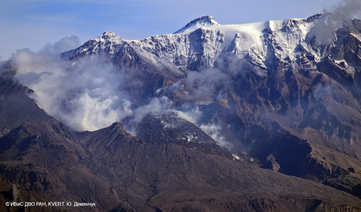
Volcanic Activity Summary:
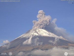
Video and satellite data by KVERT shows a strong wind lifts ash from the southern slopes of Sheveluch volcano, and a plume of resuspended ash is extending about 86 km to the eastsoutheast of the volcano.
An extrusive-effusive eruption of the volcano continues. A danger of ash explosions up to 10 km (32,800 ft) a.s.l. is remains. Ongoing activity could affect international and low-flying aircraft.
Volcanic cloud height:
3000 m (9840 ft) AMSL Time and method of ash plume/cloud height determination: 20231011/2150Z – Himawari-9 14m15
Other volcanic cloud information:
Distance of ash plume/cloud of the volcano: 86 km (53 mi)
Direction of drift of ash plume/cloud of the volcano: ESE / azimuth 106 deg
Time and method of ash plume/cloud determination: 20231011/2150Z – Himawari-9 14m15
Remarks:
resuspended ash
Source : Kvert
Photo : Yu. Demyanchuk. IVS FEB RAS, KVERT
Italy , Campi Flegrei :
Weekly bulletin, from October 2, 2023 to October 8, 2023. (Issue date October 10, 2023)
SUMMARY STATEMENT OF ACTIVITY
In light of the monitoring data, it appears:
1) SISMOLOGY: In the week of October 2 to 8, 2023, in the Campi Flegrei area, 104 earthquakes of magnitude Md≥0.0 (Mdmax=4.0±0.3) were located.
2) DEFORMATIONS: From January 2023, the average value of the lifting speed in the maximum deformation zone is approximately 15±3 mm/month. Between September 21 and 23, a ground elevation of approximately 1 cm was recorded at the RITE GNSS station. Subsequently, the uplift rate appears to have returned to previous values recorded in 2023. The uplift recorded at the RITE GNSS station is approximately 26 cm since January 2022.
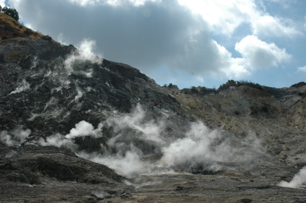
3) GEOCHEMISTRY: There are no significant variations in the geochemical parameters monitored in the reference period compared to the already known trends of increased flow and warming of the hydrothermal system. The temperature sensor installed in a fumarole emission 5 meters from the main Pisciarelli fumarole showed an average value of ~95°C, condensation temperature of the fumarole liquid. The absence of liquid in the Pisciarelli basin remains, indicative of a reduced supply of fumarolic condensates.
SEISMOLOGY
In the week of October 2 to 8, 2023, 104 earthquakes of magnitude Md≥0.0 (Mdmax=4.0±0.3) were located in the Campi Flegrei area.
44 earthquakes were recorded during 2 seismic swarms:
● the first, from 8:08 p.m. UTC on October 2, 2023, composed of 35 earthquakes with Md≥0.0 (Mdmax=4.0±0.3) occurring in the Solfatara, Pisciarelli, Accademia area;
● the second, from 08:18 UTC on October 4, 2023, composed of 9 earthquakes with Md≥0.0 (Mdmax=2.6±0.3) occurring in the Solfatara, Accademia area.
Source : INGV
Photo : Stanley-goodspeed
Chile , Lascar :
Seismology
The seismological activity of the period was characterized by the recording of:
31 seismic events of type VT, associated with the fracturing of rocks (Volcano-Tectonics). The most energetic earthquake had a Local Magnitude (ML) value equal to 2.3, located 0.8 km east-southeast of the volcanic edifice, at a depth of 1.9 km relative to to the crater.
81 LP type seismic events, associated with fluid dynamics inside the volcanic system (Long Period). The size of the largest earthquake evaluated from the Reduced Displacement (RD) parameter was equal to 11.7 cm2.
3 TR type seismic events, associated with the dynamics maintained over time of fluids inside the volcanic system (Tremor). The size of the largest earthquake evaluated from the Reduced Displacement (RD) parameter was equal to 2.6 cm2.
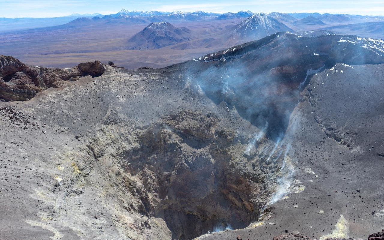
After the small eruptive crisis experienced by the volcano in January 2023, the different parameters obtained with the instrumental network showed a decrease in their values and trends, reaching a position around their usual threshold levels. Volcanic seismic activity and visual observations have stabilized in recent weeks; Relevant aspects such as incandescence and sulfur dioxide SO2 measurements remained absent and/or with low concentrations, respectively, for this volcano. Calculations to assess surface deformation, GNSS network data and InSAR, indicated an absence of notable processes within the volcanic system.
Taken together, all of the above suggests an activity that has returned to its baseline levels, for this reason it is modified to:
GREEN TECHNICAL ALERT: Active volcano with stable behavior – There is no immediate risk.
Source : Sernageomin
Photo : Vulcanopro.
Hawaii , Kilauea :
Wednesday, October 11, 2023, 8:50 AM HST (Wednesday, October 11, 2023, 18:50 UTC)
19°25’16 » N 155°17’13 » W,
Summit Elevation 4091 ft (1247 m)
Current Volcano Alert Level: ADVISORY
Current Aviation Color Code: YELLOW
Activity Summary:
Kīlauea volcano is not erupting. The area just south of Kīlauea’s summit is showing signs of episodic heightened unrest. No unusual activity has been noted along Kīlauea’s East Rift Zone or Southwest Rift Zone.
Summit Observations:
Episodic heightened unrest continues in the south summit area of Kīlauea and an eruption in the region from Halemaʻumaʻu south to the December 1974 vents could emerge with little notice (1-2 hours) during peaks in this activity. Inflation at the summit of Kīlauea remains at about its highest level in over 5 years and has nearly returned to the level seen just before the last eruption on September 10th. The Uēkahuna summit tiltmeter located north of the caldera recorded very slight inflation over the past 24 hours.
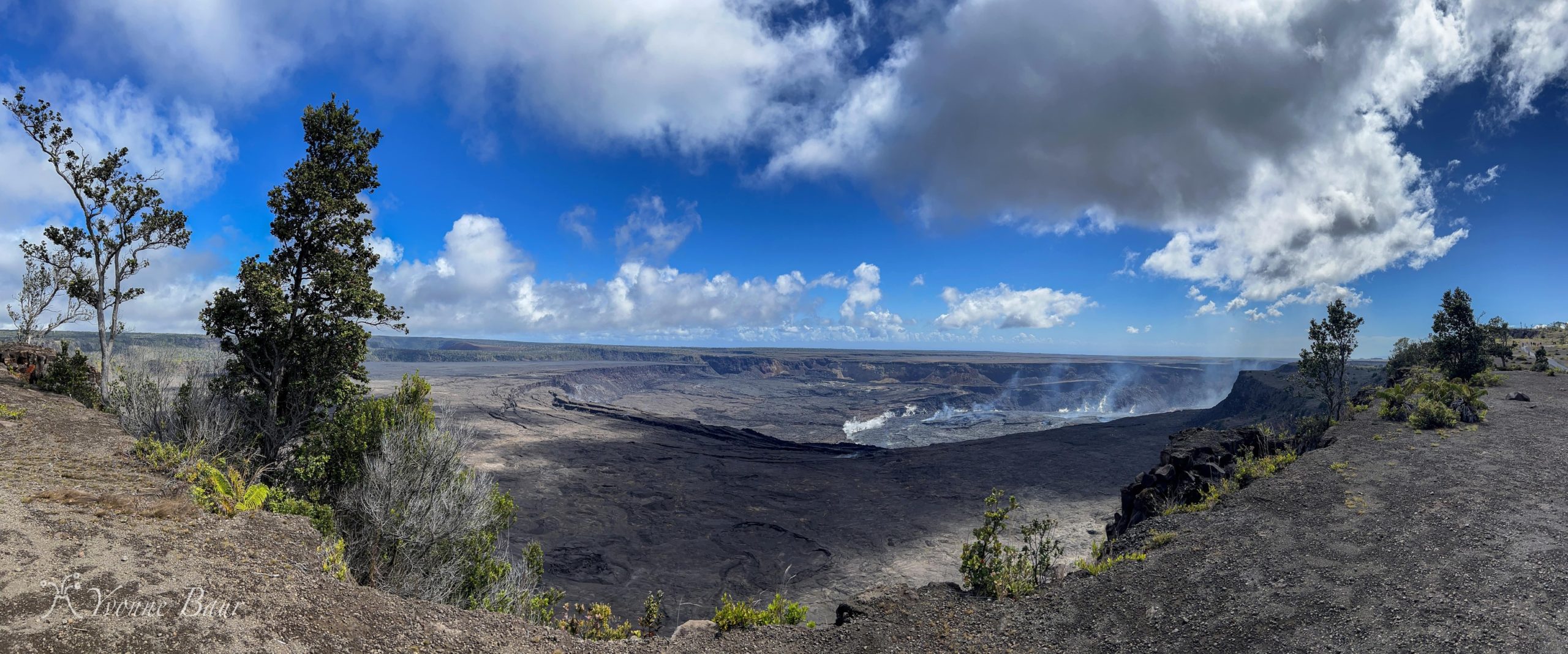
The Sand Hill tiltmeter located just south of the caldera went off scale during the peak activity on October 6th, but has been reset and is showing continued inflation but at a lower rate than before the event. GPS units within the south end of the caldera and further south also show continued uplift of this region. Elevated seismicity is being recorded beneath the south end of Kīlauea caldera and extends to the southwest along the trend of December 1974 vents. Seismicity increased on October 4, peaked at over 250 earthquakes per day on October 5 and 6, and continues dispersed over this area. Over the past 24 hours, approximately 134 earthquakes were recorded in Kīlauea summit region. Most of the earthquakes from the seismic swarm south of the caldera are at depths of around 0.5–4 km (0.3–2.5 mi) below the surface. Sulfur dioxide (SO2) emission rates remain low and were measured at a rate of about 100 tonnes per day on October 6.
Source : HVO
Photo : Yvonne Baur