August 13 , 2023.
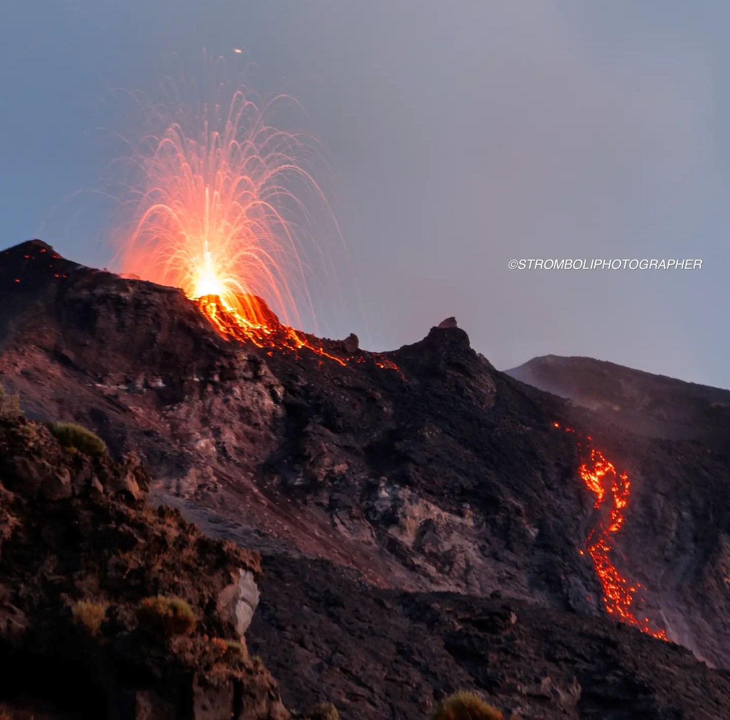
Italy , Stromboli :
Statement on Stromboli activity, August 12, 2023, 10:43 (08:43 UTC).
The National Institute of Geophysics and Volcanology, Osservatorio Etneo, communicates that from about 08:00 (UTC), a small overflow of lava is gradually forming, fed by one of the mouths of the North crater area, on the upper part of the Sciara del Fuoco. At present, this flow has reached a length of 30-50 m.
At the same time, a weak projection activity is observed at the level of the same mouth which feeds the overflow.
From a seismic point of view, the average amplitude of the volcanic tremor has not shown significant variations during the last hours, remaining, until the current state, in the range of average values. There are no significant variations in the rate of occurrence and in the amplitude of the explosion tremors.
No deformation data is currently available. The last measured signals (until 06:00 UTC) show no significant change.
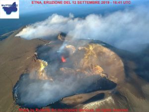
Statement on Stromboli activity, August 12, 2023, 16:24 (14:24 UTC).
The National Institute of Geophysics and Volcanology, Osservatorio Etneo, reports that in the past few hours, spatter activity in the North Crater area has intensified and the rate of outpouring has increased, fueling the lava flow that started this morning, which has now reached a length of about a hundred meters, however, remaining confined to the upper part of the Sciara del Fuoco. We also observe the detachment of blocks from the lava front, which roll frequently to the lower part of the Sciara.
From a seismic point of view, compared to what was reported in the previous press release, the parameters monitored do not show any significant variations. For the sake of completeness of the information, we report a very modest increase in the average level of the amplitude of the volcanic tremor, which however always remains confined to the average level.
The currently available deformation signals measured by the GNSS network show no significant change.
Further updates will be communicated soon.
Source : INGV.
Photo : Stromboli stati d’animo / Sebastiano Cannavo
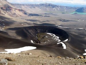
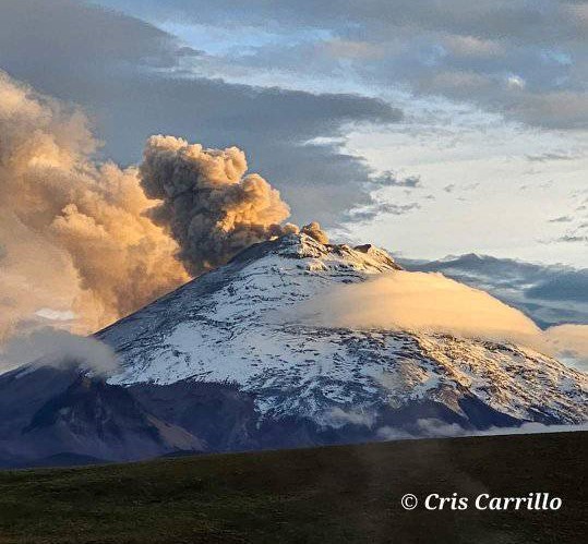
Ecuador , Cotopaxi :
Seismicity
Several seismic parameters of the Cotopaxi volcano have shown a gradual decline in recent months. After the February peak, smaller, less prominent, and short-lived pulses were produced over the following months, with ever-decreasing frequency of occurrence. The last significant pulse of ash emission occurred on July 6.
The average magnitude of localized events shows a clear decrease compared to the end of February, to then rise and oscillate, but without reaching levels as high as those of February. The current level represented by this indicator shows that there is not enough energy to generate a new pulse of seismic activity, which usually accompanies somewhat more intense eruption phases, such as what happened in January and February of this year.
Deformation
Based on the varying deformation patterns observed in July in the North – South section and the trend, which remains positive in the West – East section, it is concluded that inflation has so far not fully stabilized.
Data interpretation
Based on the information available, it is concluded that the activity of the Cotopaxi volcano has reached a low level at the surface level and remains at a moderate level internally. A joint analysis of those of the different monitoring parameters suggests that the recent activity of Cotopaxi was caused by the presence of a small body of magma, which is responsible for the emissions of SO 2 and ash emitted during these more than 10 months of activity.
There is NO evidence showing any new volume of magma entering the surface system in recent months. Consequently, some of the monitoring parameters show a decrease in their trends and the surface activity is low.
Currently, the surface activity of Cotopaxi is characterized by the emission of columns of gas and water vapor which generally do not exceed 1000 m above the level of the crater. Gases of magmatic origin, notably SO2, are still present in the volcanic plume, but show a gradual decrease since February in both permanent instruments and satellite data. Internally, seismicity continues to be dominated by LP-type earthquakes and less and less energetic tremor episodes. The deformation has not stabilized and varying trends are observed, with no evidence of a clear increase or a definite deflationary trend.
Source : IGEPN
Photo : Cris Carrillo.
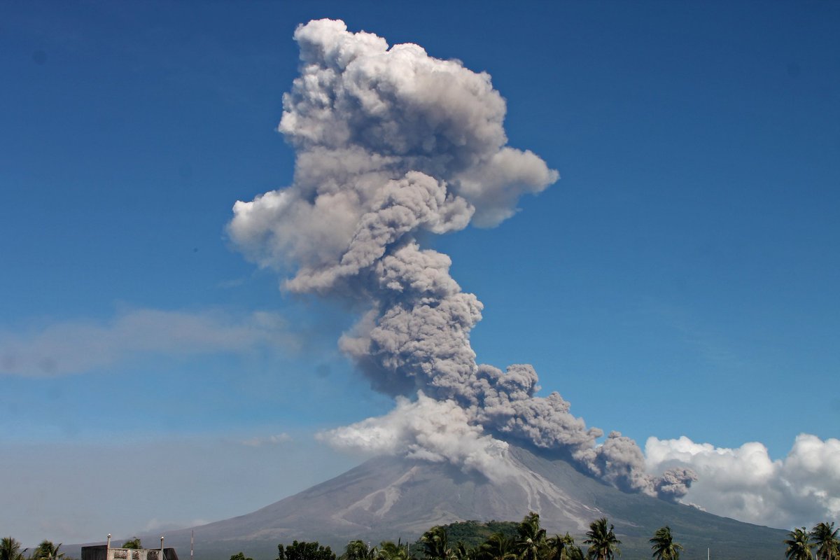
Philippines , Mayon :
MAYON VOLCANO BULLETIN 13 August 2023 8:00 AM
In the past 24-hour period, slow effusion of lava from the summit crater of Mayon Volcano continued to feed the established lava flows on the Bonga (southeastern), Mi-isi (south), and Basud (eastern) gullies. The lava flows have maintained their respective advances to approximately 3.4 kilometers, 2.8 kilometers, and 1.1 kilometers from the crater. Rockfall and pyroclastic density currents or PDCs generated by collapses of the lava flow margins as well as of the summit dome deposited debris still within four (4) kilometers of the crater. The Mayon Volcano Network recorded a total of two hundred twenty-one (221) volcanic earthquakes including one hundred eleven (111) tremor events lasting one (1) to twenty-eight (28) minutes. Some of these tremors were accompanied by rumbling sounds audible within the 7-km radius from the crater of Mayon. Additionally, the network detected one hundred fifty-two (152) rockfall events, three (3) PDCs, and three (3) lava front-collapses. Volcanic sulfur dioxide (SO2) emission averaged 799 tonnes/day on 12 August 2023.
Short-term observations from electronic tilt and GPS monitoring indicate a deflation of the eastern lower flanks in early July 2023 and inflation of the northwest middle flanks in the third week of July 2023. Longer-term ground deformation parameters from EDM, precise leveling, continuous GPS, and electronic tilt monitoring indicate that Mayon is still generally inflated relative to baseline levels.
Alert Level 3 is maintained over Mayon Volcano, which means that it is currently in a relatively high level of unrest and hazardous eruption within weeks or even days could still be
Source : Phivolcs.
Photo : Auteur inconnu
Hawaii , Kilauea :
19°25’16 » N 155°17’13 » W,
Summit Elevation 4091 ft (1247 m)
Current Volcano Alert Level: ADVISORY
Current Aviation Color Code: YELLOW
Activity Summary:
Kīlauea volcano is not erupting. No significant changes have been observed at the summit or in either rift zone over the past week.
Summit Observations:
Over the past week, seismicity has continued at low levels, but with a slight increase in the number of events compared to previous weeks including a small flurry on August 6. Summit tiltmeters recorded minor net inflation over the past week. Sulfur dioxide (SO2) emissions from the summit remain low; the most recent SO2 emission rate, of approximately 121 tonnes per day, was measured on August 6.
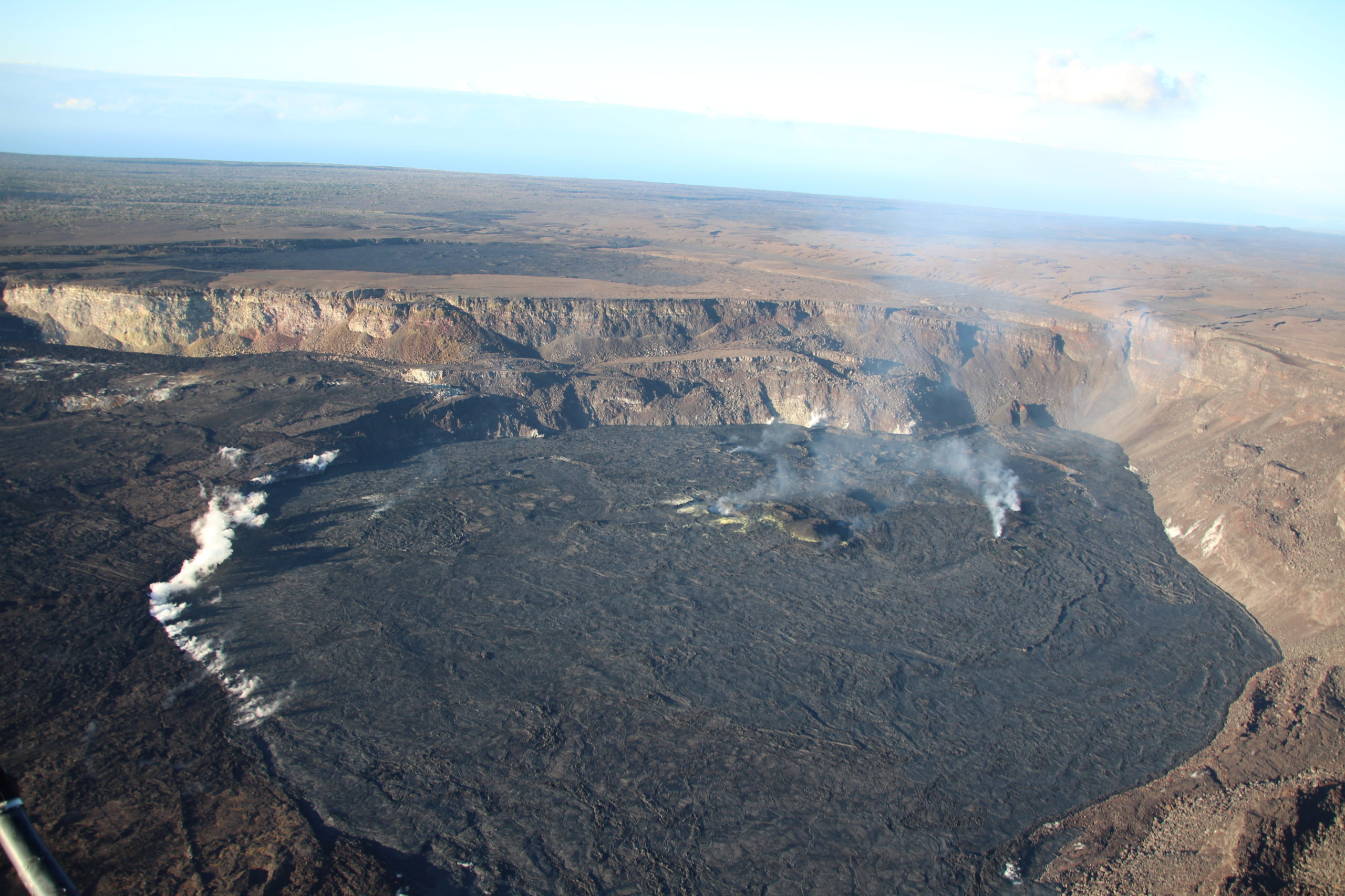
Halemaʻumaʻu Lava Lake Observations:
No active lava has been observed since June 19.
East Rift Zone Observations:
No unusual activity has been noted along the East Rift Zone or Southwest Rift Zone; steady rates of ground deformation and seismicity continue along both. Measurements from continuous gas monitoring stations downwind of Puʻuʻōʻō in the middle East Rift Zone remain below detection limits for SO2, indicating that SO2 emissions from Puʻuʻōʻō are negligible.
Source : HVO
Photo : USGS / N. Deligne.
Costa Rica , Poas :
Latitude: 10.20°N;
Longitude: 84.23°W;
Altitude: 2687m
Current activity level: warning
Possible manifestations: Small eruptions, bubbling or geyser, significant gas emission, temperature rise (incandescence), seismic swarms or volcanic tremor, slight inflation-extension of the volcanic edifice.
A small phreatic eruption was recorded on August 3 at 1:53 a.m., reaching about 20m high. The outlet, located west of the crater, was not known as a possible focus of eruption. The tremor remains variable but mainly with low amplitudes and a wide spectrum of frequencies. Low frequency volcanic earthquakes continue to be recorded.
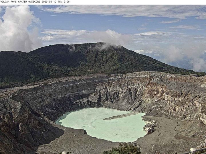
Geodetic measurements detect a contraction of the volcanic mass without significant vertical movement. Over the past month, the SO2 flux has not shown significant changes. During the past week, 150 ± 48 t/d were recorded. The gas ratios measured in the plume remain within normal ranges with weekly averages of SO2/CO2 = 1.06 +/- 0.23 and H2S/SO2 <0.01. The maximum weekly SO2 concentration recorded at the watchtower was 4.6 ppm. The mass of SO2 emitted by the Poás volcano measured by the Sentinel-2 TROPOMI satellite shows a higher detection frequency in 2023 and 2022 than in 2021, suggesting a slight increase in the long-term gas emission baseline . The level of the lake decreased by about 0.8 m in 2 weeks.
Source et photo : Ovsicori.