August 12 , 2023.
Indonesia , Merapi :
Report on the activity of Mount Merapi from August 04, 2023 to August 10, 2023, Published on August 11, 2023.
RESULTS OF OBSERVATIONS
Visual
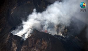
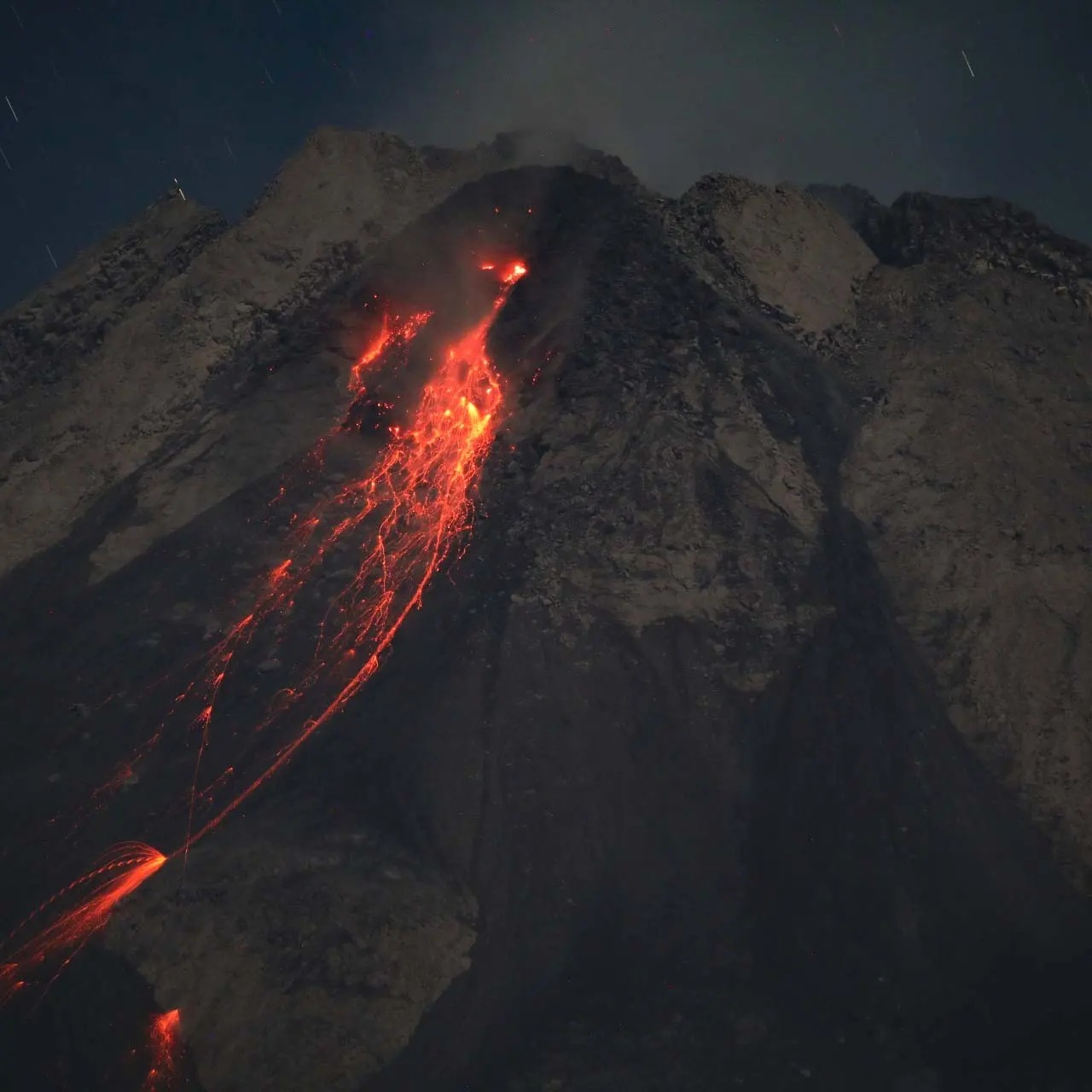
The weather around Mount Merapi is usually sunny in the morning and afternoon, while the evening is foggy. White smoke, fine to thick, low to medium pressure and 450 m high was observed from the observation post of Mount Merapi in Badaban on August 4, 2023 at 05:55.
This week, lava avalanches were observed 198 times to the south and southwest, including 15 times upstream of the Boyong River to a maximum of 1,900 m, 180 times upstream of the Bebeng River to at 2000m and 3 times upstream of the Sat/Putih Kali river to a maximum of 1600m. The sound of the avalanches was heard 28 times from Babadan post with low to moderate intensity.
On the Southwest dome, the highest hotspots reached 412°C and on the central dome, they reached 180°C. The morphology of the Southwest dome has undergone changes due to growth activity and lava avalanches, while no significant changes have been observed for the central dome. Based on an analysis of aerial photos on August 10, 2023, the measured volume of the southwest dome was 2,764,300 m3 and the central dome was 2,369,800 m3.
Seismicity
This week, the seismicity of Mount Merapi showed:
5 shallow volcanic earthquakes (VTB),
86 multiphase earthquakes (MP),
1 low frequency (LF) earthquakes,
1033 avalanche earthquakes (RF)
12 tectonic earthquakes (TT).
The intensity of seismicity this week is lower than last week, but the number of earthquakes is still quite high.
Deformation
Mount Merapi’s deformation that was monitored using EDM this week showed a shortening in steepening distance of 0.1 cm/day.
Rain and lahars:
This week, it rained at the Mount Merapi observation post with a rain intensity of 24 mm/hour for 15 minutes at the Kaliurang post on August 6, 2023. There were no reports of additional flows or lahars from rivers that descend from Mount Merapi.
Conclusion
Based on the results of visual and instrumental observations, it is concluded that:
-The volcanic activity of Mount Merapi is still quite high in the form of effusive eruption activity. The state of the activity is defined at the « SIAGA » level.
The current danger potential is in the form of lava avalanches and hot clouds in the South-South-West sector comprising the Boyong River for a maximum of 5 km, the Bedog, Krasak, Bebeng rivers for a maximum of of 7 km. In the South-East sector, it includes the Woro River for a maximum of 3 km and the Gendol River for 5 km. While the ejection of volcanic material in the event of an explosive eruption can reach a radius of 3 km from the summit.
Source : BPPTKG
Photos : Andi volcanist
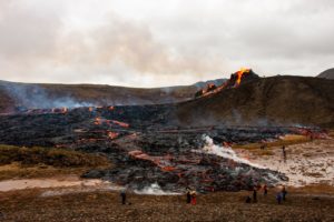
Alaska , Shishaldin :
54°45’19 » N 163°58’16 » W,
Summit Elevation 9373 ft (2857 m)
Current Volcano Alert Level: WATCH
Current Aviation Color Code: ORANGE
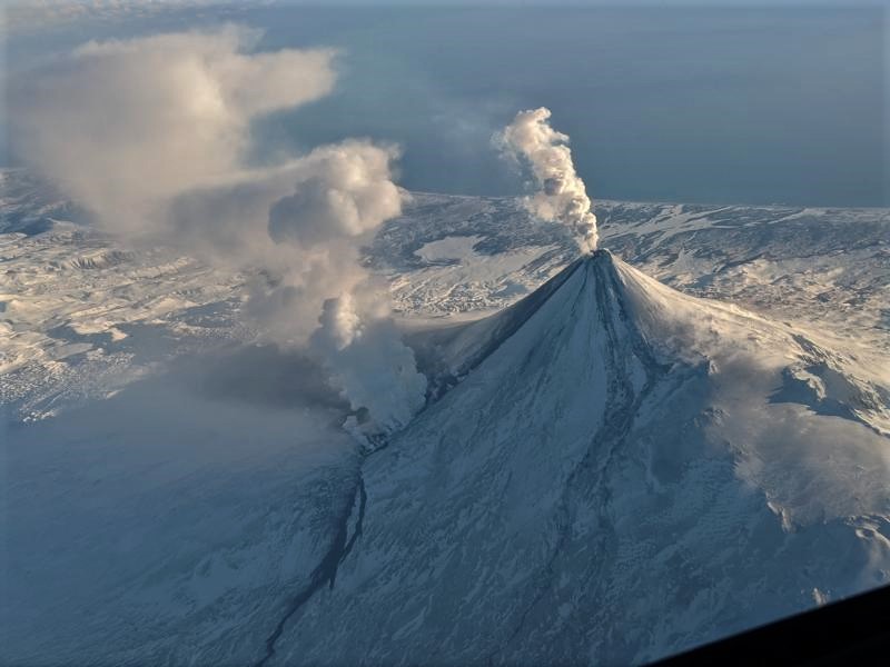
The most recent significant explosive event ended last week on the evening of August 4, when the Aviation Color Code and Volcano Alert Level was lowered to ORANGE/WATCH, where it currently remains. Following the eruption, satellite imagery revealed changes to the summit crater and flanks of the volcano. Many of the drainages on the upper flank of the volcano have been filled in with pyroclastic deposits extending 0.6–1.2 miles (1-2 km) in length, while mud and debris flows have scoured some drainages further down the flanks. The summit crater was also mostly filled with deposits from the eruption, and a small lava flow was observed extending from the crater rim to the upper northeast flank of the volcano. This flow advanced to about 180 ft (55 m) in length by August 9, but appears stalled in imagery from August 11.
Elevated surface temperatures were observed in satellite data throughout the week, which are caused by the small lava flow at the summit, and steaming was observed in web camera images on August 11. Seismicity remains slightly elevated, but no significant explosive activity was observed in seismic or infrasound data.
Shishaldin has now had six periods of elevated eruptive activity resulting in significant ash emissions during the current eruption which started on July 12. It is unknown how long this eruption will last, but previous eruptions of Shishaldin Volcano have lasted weeks to months with repeated cycles of activity similar to those seen in the last month. Before the current activity, the 2019–2020 eruption of Shishaldin was the first to result in lava flows outside of the crater area since 1976. Minor eruptions in 2004 and 2014 erupted lava confined to the summit crater. Eruptions from Shishaldin have produced ash clouds in the past like those seen during the current eruption, most recently in January 2020. Satellite, seismic, and infrasound data is routinely monitored for signs of explosions that might produce ash clouds.
Shishaldin Volcano is monitored by local seismic and infrasound sensors, web cameras, and a geodetic network. In addition to the local monitoring network, AVO uses nearby geophysical networks, regional infrasound and lighting data, and satellite observations to detect eruptions.
Source : AVO.
Photo : Brekke, Matt
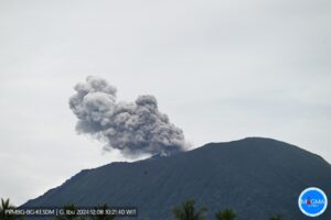
Indonesia , Ili Lewotolok :
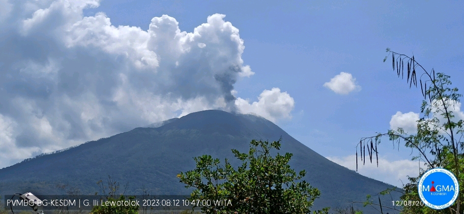
An eruption of G. Ili Lewotolok occurred on Saturday August 12, 2023 at 10:45 WITA with an ash column height observed at ± 800 m above the summit (± 2223 m above sea level) . The ash column was observed to be gray with thick intensity, oriented to the west and northwest. This eruption was recorded on a seismograph with a maximum amplitude of 30.7 mm and a duration of 120 seconds.
VOLCANO OBSERVATORY NOTICE FOR AVIATION – VONA
Issued : August 12 , 2023
Volcano : Ili Lewotolok (264230)
Current Aviation Colour Code : ORANGE
Previous Aviation Colour Code : orange
Source : Ili Lewotolok Volcano Observatory
Notice Number : 2023LEW043
Volcano Location : S 08 deg 16 min 19 sec E 123 deg 30 min 18 sec
Area : East Nusa Tenggara, Indonesia
Summit Elevation : 4554 FT (1423 M)
Volcanic Activity Summary :
Eruption with volcanic ash cloud at 02h45 UTC (10h45 local).
Volcanic Cloud Height :
Best estimate of ash-cloud top is around 7114 FT (2223 M) above sea level or 2560 FT (800 M) above summit. May be higher than what can be observed clearly. Source of height data: ground observer.
Other Volcanic Cloud Information :
Ash cloud moving from west to northwest. Volcanic ash is observed to be gray. The intensity of volcanic ash is observed to be thick.
Remarks :
Eruption recorded on seismogram with maximum amplitude 30.7 mm and maximum duration 120 second.
Source : Magma Indonésie
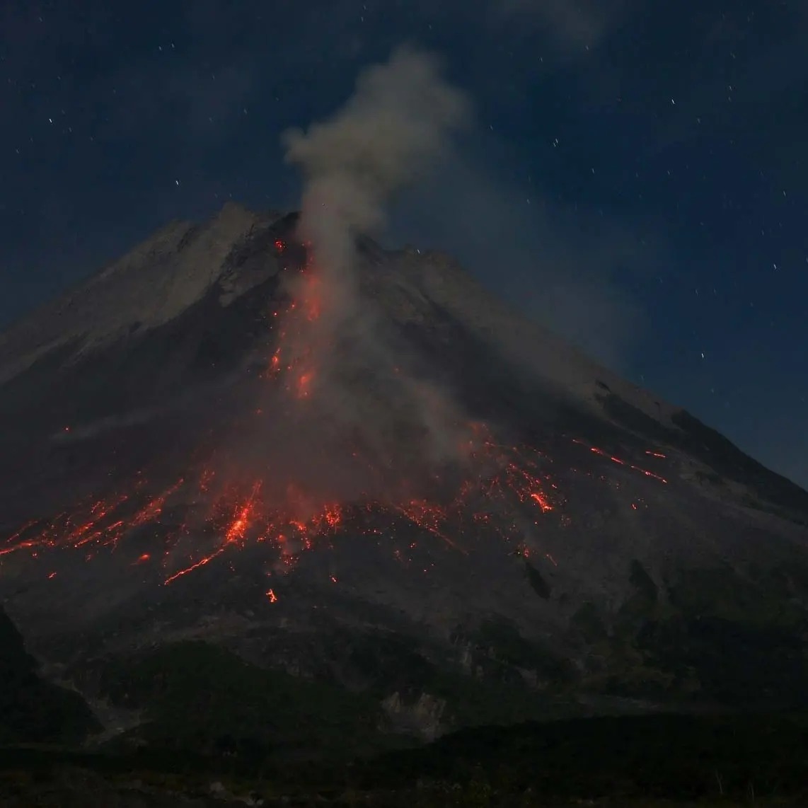
Kamchatka , Sheveluch :
56.64 N, 161.32 E;
Elevation 3283 m (10768 ft),
Dome elevation ~2500 m (8200 ft)
Aviation Colour Code : ORANGE
An extrusive-effusive eruption of the volcano continues. A danger of ash explosions up to 10 km (32,800 ft) a.s.l. remains. Ongoing activity could affect international and low-flying aircraft.
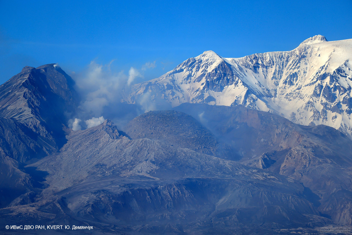
The growth of the lava dome in the explosive crater formed on 10-13 April, 2023 continues. A plastic lava covers the slopes of the dome by lava flows.
An extrusive-effusive eruption of the volcano continues: a lava is squeezed out in the explosive crater of the Young Sheveluch, it is accompanied by powerful gas-steam activity, and sometimes an incandescence of the lava dome. A powerful gas-steam activity is also observed at the area of the Karan dome, probably associated with a preparation for a lava dome growth. Satellite data by KVERT showed a thermal anomaly over the volcano on August 5-7 and 9, the volcano was obscured by clouds during other days of the week.
Source : Kvert
Photo : Yu. Demyanchuk, IVS FEB RAS, KVERT
La Réunion , Piton de la Fournaise :
Press release from the Paris Institute of Earth Physics, Piton de la Fournaise Volcanological Observatory
August 12, 2023 – 06:50 local time – 02:50 UTC time
Earthquake felt
On August 11, 2023, 8:31 p.m. (local time – i.e. 4:31 p.m. GMT), an earthquake was felt by some inhabitants of the island, mainly in the Cirque de Salazie sector.
This earthquake was recorded by the seismometers of the Volcanological Observatory of Piton de la Fournaise. The first analyzes of this earthquake made it possible to locate it, 17.9 km below sea level to the north of Grand Étang. Its magnitude has been measured at 1.8 on the Richter scale.
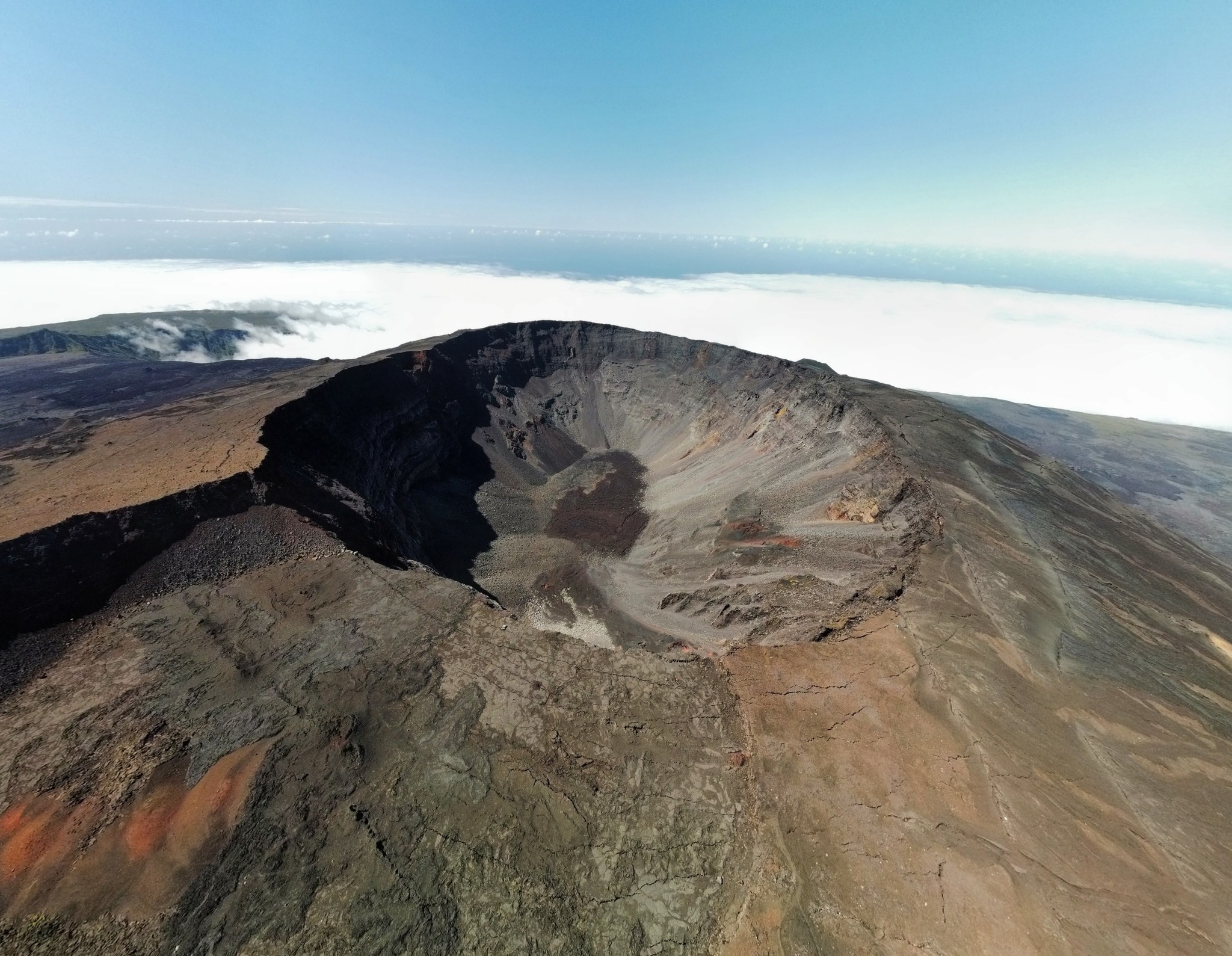
This type of event, felt by the population, is recorded several times a year. This event is isolated and is of tectonic origin. At present, this earthquake has not been followed by aftershocks.
Call for testimonies on felt earthquakes: the real intensities (effects of an earthquake in a given place) can only be correctly determined by collecting testimonies. If you felt this earthquake, even weakly, you are invited to report it to the BCSF (Bureau Central Sismologique Français) on the site http://www.franceseisme.fr/
Source : OVPF.
Photo : Tunnels de lave Réunion : Rando-Volcan