August 11 , 2023 .
La Réunion , Piton de la Fournaise :
Press release from the Institute of Earth Physics of Paris, Volcanological Observatory of Piton de la Fournaise
August 10, 2023 – 07:30 – 03:30 UTC
End of eruption
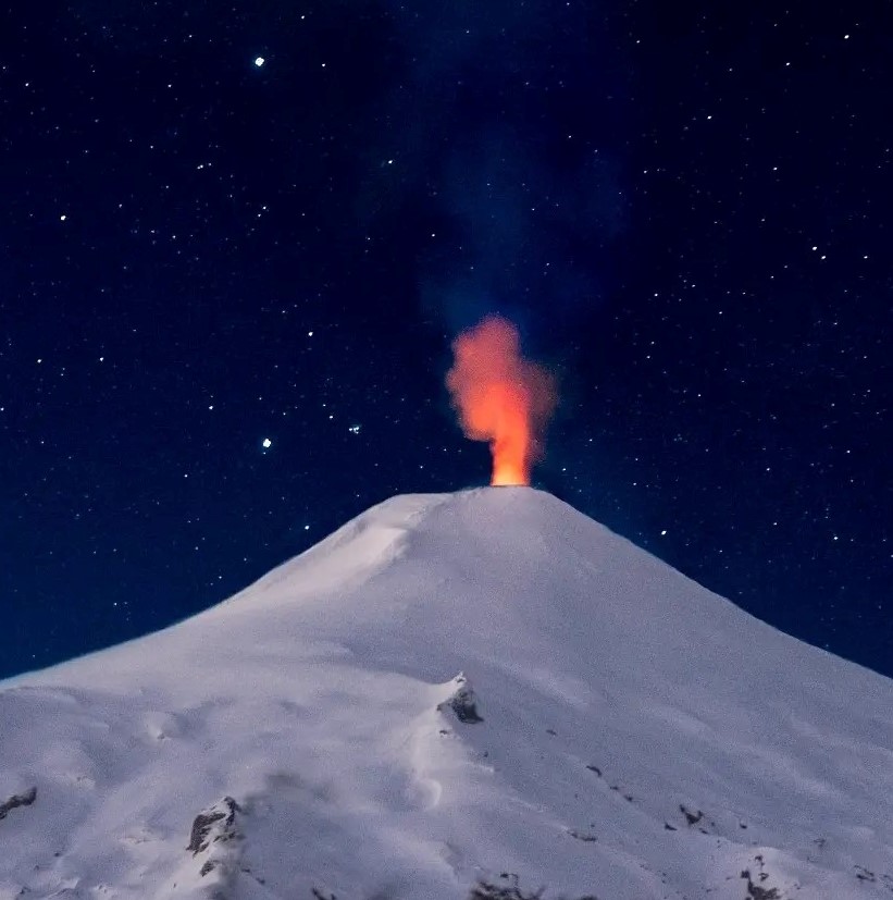
The eruption started on 07/02/2023, around 08:30 local time, stopped today, 08/10/2023, around 05:00 local time (01:00 UTC), after a piston gas phase.
No hypothesis has been ruled out for the moment as to the evolution of the future situation (definitive cessation, resumption of activity on the same site, resumption of activity on another site), taking into account the continuation building inflation.
Recommended Alert Level: Backup
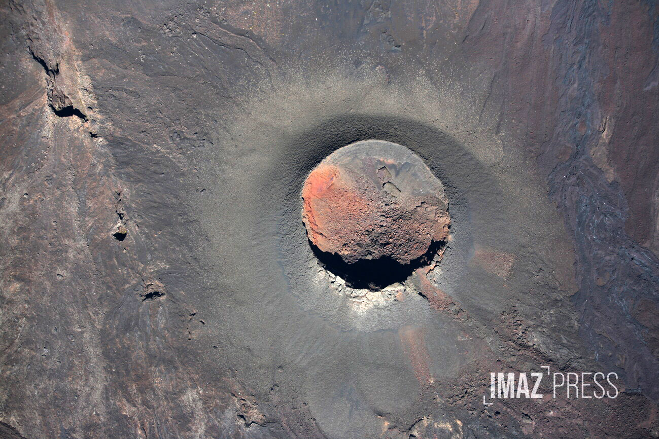
The Piton de la Fournaise went back to sleep this Thursday morning August 10, 2023. « The eruption that started on Sunday July 2, 2023 stopped today around 5 a.m. » informs the volcanological observatory. « No hypothesis has been ruled out for the moment as to the evolution of the future situation (definitive shutdown, resumption of activity on the same site, resumption of activity on another site), taking into account the continuation of the inflation of the building » specify the volcanologists. Access to the enclosure remains prohibited for the time being
Source : OVPF, Imaz Press .
Photo : rb/www.imazpress.com
New Britain , Ulawun :
Rabaul Volcano Observatory (RVO) reported that small, diffuse, white plumes rose from Ulawun’s summit during 27 July-4 August when there were extended periods of good visibility from the webcam in Ulamona (11-12 km NW). Seismicity fluctuated at moderate levels and was dominated by volcanic tremor; RSAM values ranged from 380 to 800. The Alert Level was lowered to Stage 1 (the lowest level on the four-level scale) on 31 July. Overall, RSAM showed a slow and erratic upward trend during 15 July-4 August and corresponded to an increase in volcanic tremor amplitudes. RVO warned that minor eruptive activity may occur if the trend continued and that ash emissions had previously occurred at similar RSAM levels.
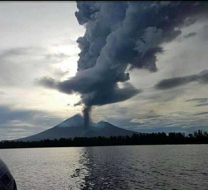
The symmetrical basaltic-to-andesitic Ulawun stratovolcano is the highest volcano of the Bismarck arc, and one of Papua New Guinea’s most frequently active. The volcano, also known as the Father, rises above the N coast of the island of New Britain across a low saddle NE of Bamus volcano, the South Son. The upper 1,000 m is unvegetated. A prominent E-W escarpment on the south may be the result of large-scale slumping. Satellitic cones occupy the NW and E flanks. A steep-walled valley cuts the NW side, and a flank lava-flow complex lies to the south of this valley. Historical eruptions date back to the beginning of the 18th century. Twentieth-century eruptions were mildly explosive until 1967, but after 1970 several larger eruptions produced lava flows and basaltic pyroclastic flows, greatly modifying the summit crater
Source: Rabaul Volcano Observatory (RVO) , GVP .
Photo : Auther A Balisi ( Archives).
Peru , Ubinas :
UBINAS (PROVINCE OF GENERAL SÁNCHEZ CERRO) – IN ERUPTION PROCESS
o Eruptive process with moderate levels.
o During the last 24 hours, ash and gas emissions have been recorded with heights of up to 1,500 m above the summit of the volcano. Likewise, 71 earthquakes associated with rock fracturing processes inside the volcano, 79 seismic signals related to the movement of fluids and gases, as well as 6 cumulative hours of seismic signals related to ash emissions.
o According to the analysis of satellite images and the SENAMHI dispersion model, the dispersion of ashes and gases took place towards the South, South-East and East sectors, towards the municipalities of Ubinas, Matalaque, Chojata and centers populated, as well as farms and grazing areas.
o The approximate radius affected by the ashfall after today’s emissions is within 20 km of the crater, that is to say in the area of the districts of Ubinas, Matalaque and Chojata.
o Satellite systems did not detect any thermal anomalies on the surface of the crater.
o The monitoring of the deformation on the volcanic structure shows variations of less than 7 mm of displacement (slight tendency to inflation).
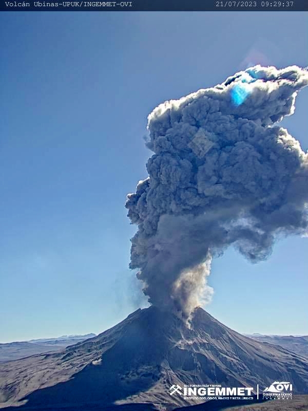
Conclusion:
The Ubinas volcano has developed an eruptive process of moderate levels, characterized by the recording of significant internal seismic activity and ash emissions. During the past 24 hours, ash and gas emissions have been recorded up to 1,500 m above the summit of the volcano. The population must remain attentive to possible ash falls and follow the recommendations issued by the Civil Protection authorities.
Recommendation:
Stay tuned for vulcanological reports and bulletins issued by the IGP via CENVUL.
Current Volcanic Alert Level: Orange
Source : Cenvul
Photo : Ingemmet ( archive).
Philippines , Mayon :
MAYON VOLCANO BULLETIN 11 August 2023 8:00 AM
In the past 24-hour period, slow effusion of lava from the summit crater of Mayon Volcano continued to feed the established lava flows on the Bonga (southeastern), Mi-isi (south), and Basud (eastern) gullies. The lava flows have maintained their respective advances to approximately 3.4 kilometers, 2.8 kilometers, and 1.0 kilometers from the crater. Rockfall and pyroclastic density currents or PDCs generated by collapses of the lava flow margins as well as of the summit dome deposited debris still within four (4) kilometers of the crater. The Mayon Volcano Network recorded a total of sixty-two (62) low-frequency volcanic earthquakes or LFVQs including four (4) ashing events, and one hundred six (106) tremor events lasting five (5) to fifteen (15) minutes. Some of these tremors were accompanied by rumbling sounds audible within the 7-km radius from the crater of Mayon. Additionally, the network detected one hundred eighty (180) rockfall events and three (3) PDCs.
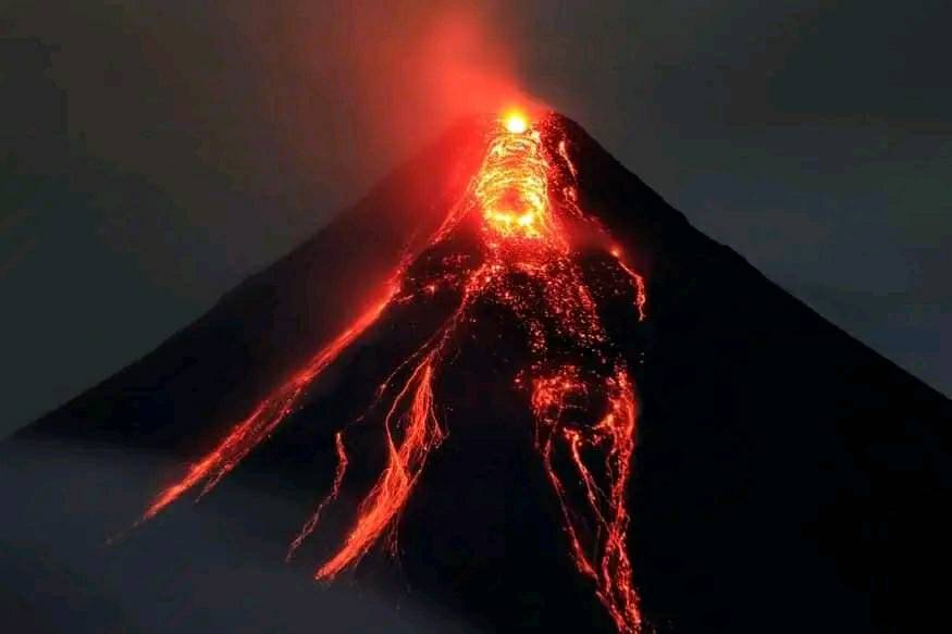
Volcanic sulfur dioxide (SO2) emission averaged 1,905 tonnes/day on 10 August 2023. Short-term observations from electronic tilt and GPS monitoring indicate a deflation of the eastern lower flanks in early July 2023 and inflation of the northwest middle flanks in the third week of July 2023. Longer-term ground deformation parameters from EDM, precise leveling, continuous GPS, and electronic tilt monitoring indicate that Mayon is still generally inflated relative to baseline levels.
Alert Level 3 is maintained over Mayon Volcano, which means that it is currently in a relatively high level of unrest and hazardous eruption within weeks or even days could still be possible.
Source : Phivolcs
Photo : Lan Po Lan
Chile , Villarica :
Seismology
The seismological activity of the period was characterized by the recording of:
A continuous tremor signal associated with the fluid dynamics inside the volcano, which during the period presented an energy variation, evaluated with the RSAM parameter, between 0.7 and 1.5 um / s, values considered above their base level.
2 VT-type seismic events, associated with rock fracturing (Volcano-Tectonics). The most energetic earthquake presented a value of local magnitude (ML) equal to 1.2, located 12.2 km east-south-east of the volcanic edifice, at a depth of 9.7 km from the crater.
17,058 LP-type seismic events, associated with fluid dynamics within the volcanic system (Long Period). The size of the largest earthquake assessed from the Reduced Displacement (DR) parameter was equal to 44 cm2.
1,929 seismic events of the TR type, associated with the dynamics maintained over time of the fluids within the volcanic system (TRemor). The size of the largest earthquake assessed from the Reduced Displacement (DR) parameter was equal to 27 cm2.
Fluid Geochemistry
The sulfur dioxide (SO2) emissions data obtained by optical differential absorption spectroscopy (DOAS) equipment, corresponding to the Los Nevados and Tralco stations, installed respectively 10 km to the East-North-East and 6 km east-southeast of the active crater, had an average value of 1679 ± 406 t / d, a value higher than that reported for the previous period and which is within the usual values for this volcanic system. The maximum daily value was 2343 t/d on July 28.
No satellite anomalies of sulfur dioxide (SO2) emissions in the atmosphere have been reported in the area near the volcano, according to data published by the Troposphere Monitoring Instrument (TROPOMI) and by Mounts.
Satellite thermal anomalies
During the period, 5 thermal alerts were recorded in the area associated with the volcano, with a maximum Volcanic Radiant Power (VRP) of 6 MW on July 16, a value considered low according to data processed by Middle Infrared Observation of Volcanic Activity. (MIROVA).
Thanks to the analysis of Sentinel 2-L2A satellite images, 1 luminance anomaly was detected in the area associated with the crater on July 17. The NHI tool platform detected a maximum area of anomalous radiation in the crater area of 9,600 m2 on July 17. It should be noted that there were limitations in the display of satellite images due to adverse weather conditions.
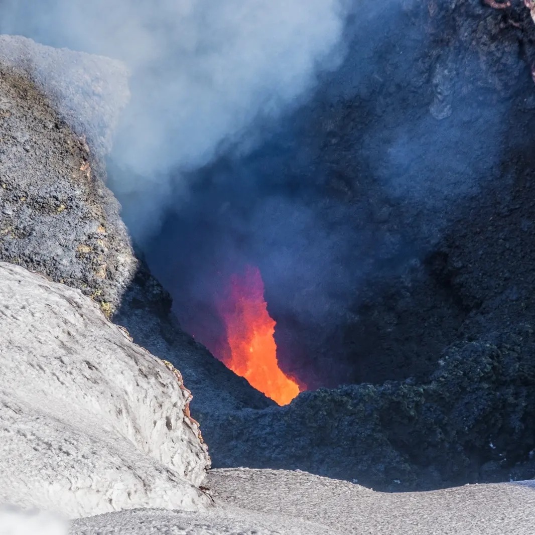
During the evaluated period, a high record of seismicity related to fluid dynamics persists. The energy of the continuous seismic signal remains stable. An increase in SO2 flux has been detected, which momentarily corresponds to a greater detection of thermal anomalies observed through the satellites. Alternately, incandescences and weak Strombolian explosions were perceived, without affecting the outer zone of the active crater. This suggests a near-surface lava lake level that conditions the aforementioned activity. Due to the above, it is inferred that the volcanic system remains with a level of activity above its base threshold and with the potential to generate surface processes, therefore, its technical alert remains yellow.
YELLOW TECHNICAL ALERT: Changes in the behavior of volcanic activity.
Source : Sernageomin
Photo : Diego Meyer