August 10 , 2023.
Italy , Stromboli :
WEEKLY BULLETIN, from July 31, 2023 to August 06, 2023. (issue date 08 August 2023)
ACTIVITY STATUS SUMMARY
In the light of the monitoring data, it is highlighted:
1) VOLCANOLOGICAL OBSERVATIONS: Ordinary explosive volcanic activity of the Strombolian type coupled with lava overflows from the northern zone of the crater. The frequency of the total explosive activity was established at a moderately average level, with an intensity varying between low and high in the areas of the North and Center-South crater.
2) SEISMOLOGY: NOTE: The bulletin is created with the data acquired from a maximum number of 7 stations.
The seismological parameters monitored do not show any significant variations.
3) DEFORMATIONS ON THE GROUND: Only a modest variation was detected in the N185E component of the TDF tilt station at the end of the evening of August 06, 2023. The GNSS network does not show any significant variations.
4) GEOCHEMISTRY: SO2 flux at an average level.
The CO2 flux in the Pizzo area shows slightly increasing average values.
The C/S ratio in the plume shows slightly increasing mean values.
There are no updates on the isotope ratio of dissolved helium in groundwater.
5) SATELLITE OBSERVATIONS: Thermal activity observed from the satellite has generally been low level with rare and isolated moderate level anomalies.
VOLCANOLOGICAL OBSERVATIONS
In the period under observation, the eruptive activity of Stromboli was characterized by the analysis of the images recorded by the network of INGV-OE surveillance cameras on the visible and on the thermal (190 m. altitude, Punta Corvi, 400 m altitude and Pizzo).
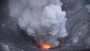
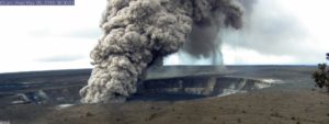
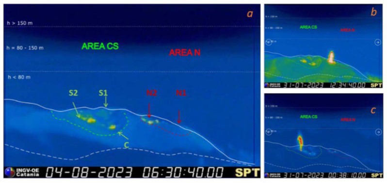
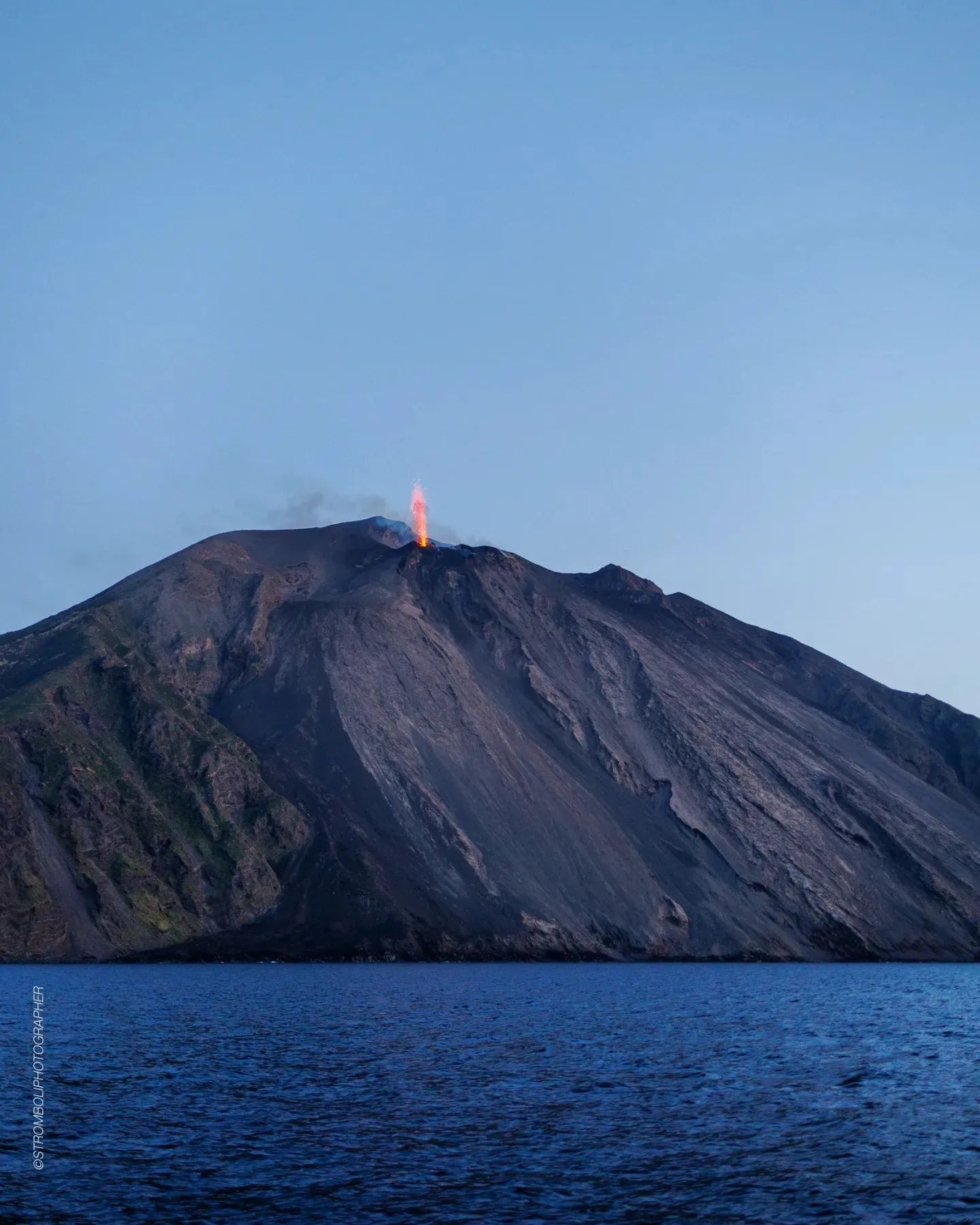
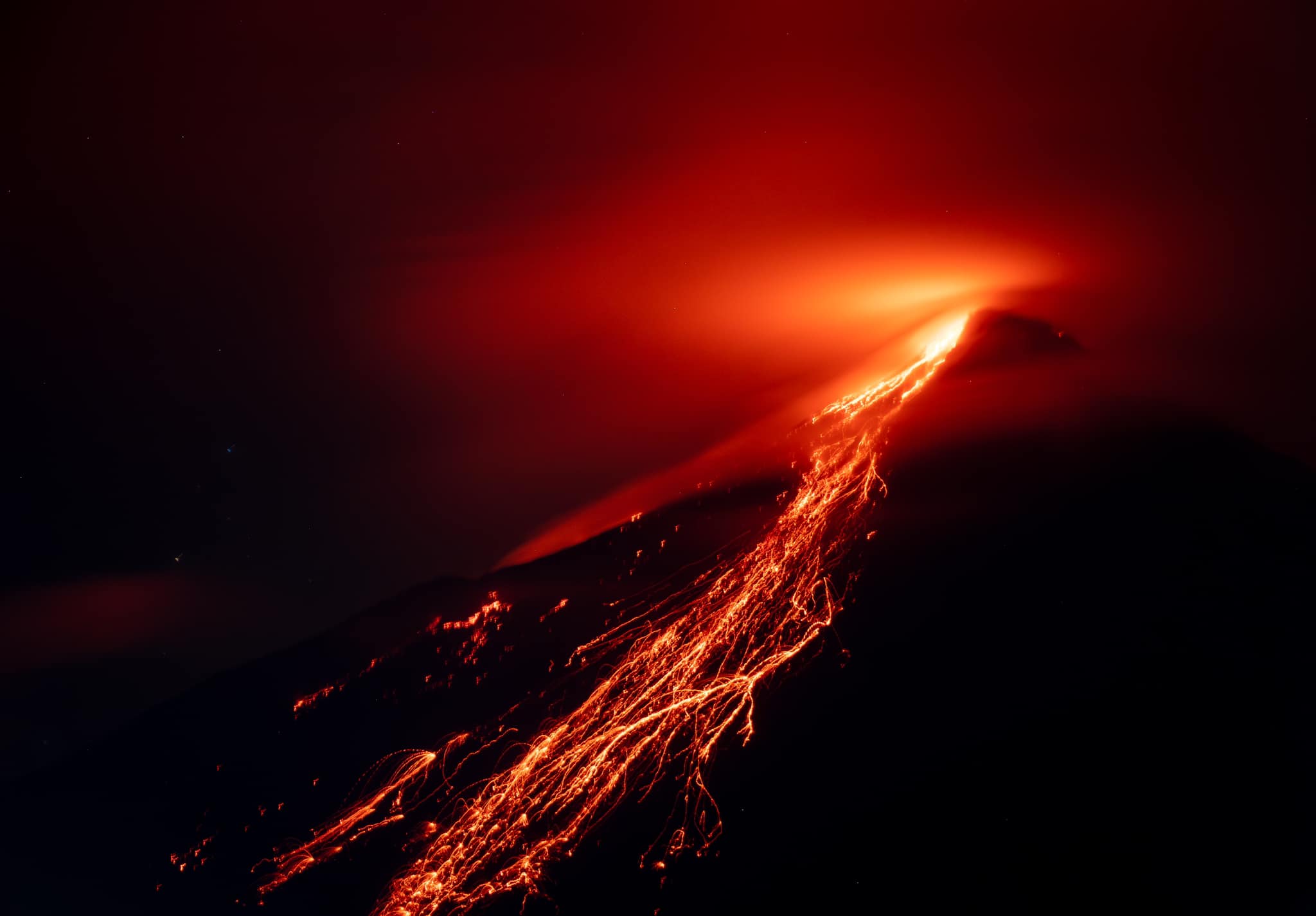
Stromboli activity was characterized by the classic ordinary explosive activity associated, between August 2 and August 6, with modest lava overflows from the northern crater area. Regarding Strombolian explosive activity, it was produced by two eruptive vents located in the area of the N1 crater and one in N2 and three vents located on the S2 in the Center-South crater area.
In the period under observation, the average / daily frequency of the total explosive activity produced by the two crater zones showed an increase between August 2 and 4, generally remaining at an average level. The average partial frequency per crater area did not show a prevalence of activity between the two crater areas. The explosions were mainly produced by N2 and N1, and by S2 with a mainly coarse component of the products emitted (bombs/lapilli) mixed with fine materials (ash) for the North zone and mainly fine for S2. In both crater areas, the intensity of the explosions varied between low and high levels. With regard to S1 and the central zone, the activity consisted of degassing at a variable pressure regime.
The spattering activity in the North area already observed the previous week continued with an increase in intensity which resulted in three modest lava overflows from the crater area. In detail, the phenomenology occurred during intense spattering phases, developing with a first abundant fallout of material produced outside the crater area (rheomorphic deposit) from which the lava overflow then proceeded. gradually developed. The lava flows were channeled into the incision immediately downstream of the northern area of the crater, flowing a few hundred meters and however remaining confined to the upper part of the Sciara del Fuoco.
This activity occurred on August 2 from about 12:30 UTC and gradual spatter depletion and flow cooling on the morning of August 3, August 6 from 4:30 UTC
approximately and cooling of the flow around 9 am of the same day. It was also repeated on August 6 in the afternoon, beginning around 6:00 p.m. UTC and gradually ending the spattering and cooling of the flow on the night of August 6–7.
Source : INGV.
Photos : INGV , Stromboli stati d’animo.
Indonesia , Karangetang :
PVMBG reported that dense white gas-and-steam plumes from Karangetang were visible rising as high as 250 m and drifting multiple directions on most days during 2-8 August. Webcam images published in the reports showed incandescence at the summit and from material on the flanks of Main Crater (S crater). According to a news source, lava avalanches traveled more than 1-1.5 km SW down the Batang, Timbelang, and West Beha drainages. Lava flows in drainages on the S and SW flanks were active; the flow in the Batuawang was 1.5 km long, the flow in Kahetang was more than 1.8 km long, and the flow in Keting was 2.1 km long.
Gray clouds sometimes accompanied lava flow activity. Incandescent material was sometimes ejected up to 25 m above the summit. During the end of the week 104 people were evacuated from the Tatahadeng and Tarorane villages, located within a 2.5-km radius of the crater, to evacuation centers and remained there at least through 9 August. Incandescence at the dome in the N crater continued to be visible. The Alert Level remained at 3 (on a scale of 1-4) and the public were advised to stay 2.5 km away from Main Crater with an extension to 3.5 km on the S and SE flanks.
Sources : Pusat Vulkanologi dan Mitigasi Bencana Geologi (PVMBG ), Antara News, GVP.
Photo : Baptiste Apps.
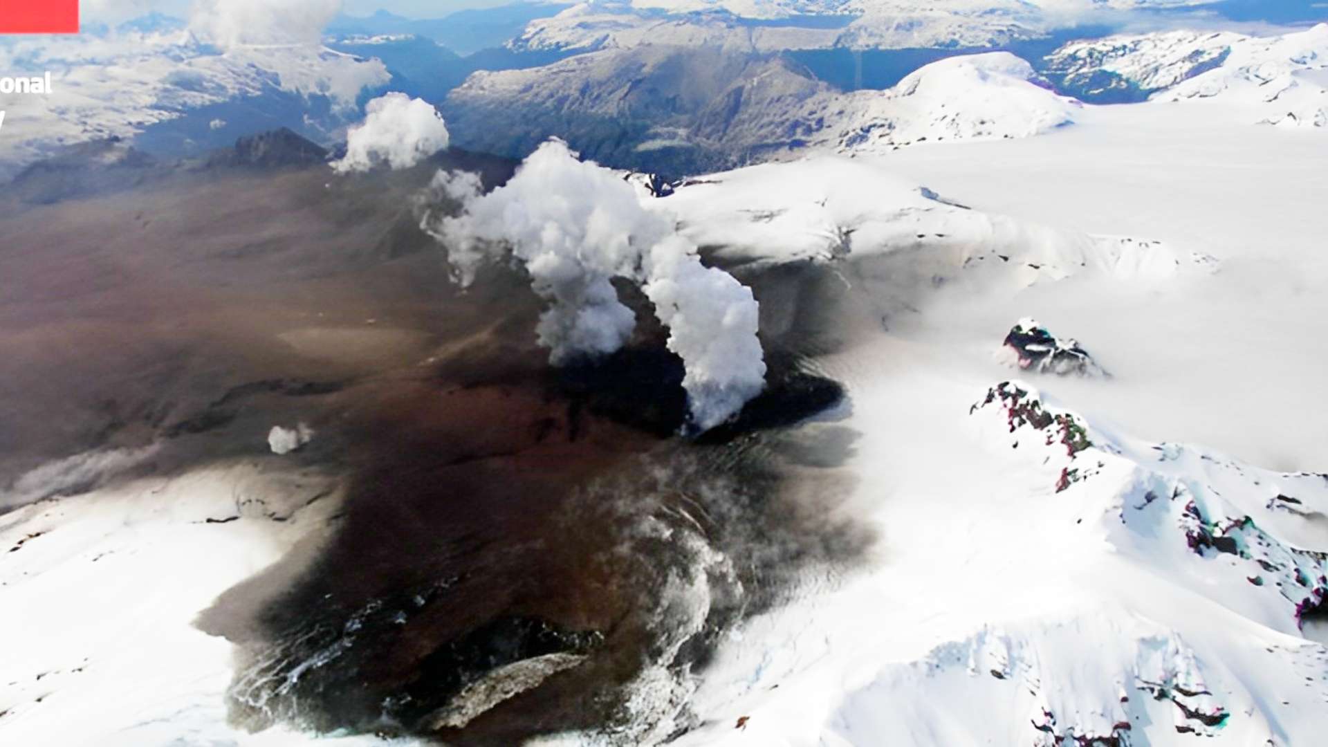
Chile , Hudson :
Seismology
The seismological activity of the period was characterized by the recording of:
176 VT-type seismic events, associated with rock fracturing (Volcano-Tectonics). The most energetic earthquake presented a local magnitude value (ML) equal to 1.6, located on the south-southeast edge of the caldera, at a depth of 5.0 km.
45 LP-type seismic events, associated with fluid dynamics within the volcanic system (Long Period). The size of the largest earthquake assessed from the Reduced Displacement (DR) parameter was equal to 6 cm2.
1 TR type seismic event, associated with the dynamics maintained over time of the fluids within the volcanic system (TRemor). The earthquake size estimated from the Reduced Displacement (DR) parameter was equal to 5 cm2.
8 HB-type seismic events, associated with both rock fracturing and fluid dynamics within the (hybrid) volcanic system. The most energetic earthquake presented a reduced displacement value (DR) of 885 cm2 and a local magnitude value (ML) equal to 2.9, located 10.9 km east-southeast of the volcanic edifice, at a depth of 25.8 km in reference to the crater. A REAV was issued for this event on July 14 at 5:25 p.m. local time.
Fluid Geochemistry
No anomalies of sulfur dioxide (SO2) emissions in the atmosphere have been reported in the area near the volcano, according to data published by the Tropospheric Monitoring Instrument (TROPOMI) and the Ozone Monitoring Instrument (OMI) Sulfur Dioxide Group.
Satellite thermal anomalies
During the period, no thermal alert was recorded in the area associated with the volcanic system, according to data processed by Middle Infrared Observation of Volcanic Activity (MIROVA),
Geodesy
No evidence of surface deformation is observed in the volcanic system for the assessed period.
Surveillance cameras
The images provided by the fixed camera, installed near the volcanic system, did not record degassing columns or variations related to surface activity.
Activity remained at levels considered low, suggesting stability of the volcanic system. The volcanic technical alert is maintained at:
GREEN TECHNICAL ALERT: Active volcano with stable behavior – There is no immediate risk.
Source et photo : Sernageomin.
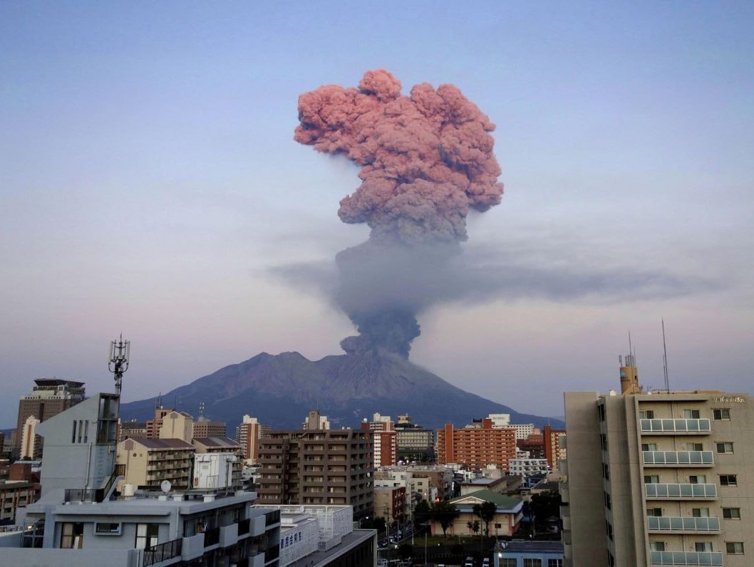
Japan , Sakurajima :
JMA reported ongoing activity at both Minamidake Crater and Showa Crater (Aira Caldera’s Sakurajima volcano) during 31 July-7 August. Nighttime incandescence at Minamidake was occasionally observed. Sulfur dioxide emissions measured during a field visit on 3 August averaged 1,800 tons per day. An eruptive event at Showa at 05h42 on 4 August produced an ash plume that rose 1 km above the crater rim and drifted N, and ejected blocks 400 m from the crater. An explosion at the same crater at 21h50 produced an ash plume that rose 2.3 km above the crater rim and drifted NW, and ejected blocks as far as 800 m from the vent. The Alert Level remained at 3 (on a 5-level scale), and the public was warned to stay 2 km away from both craters.
The Aira caldera in the northern half of Kagoshima Bay contains the post-caldera Sakurajima volcano, one of Japan’s most active. Eruption of the voluminous Ito pyroclastic flow accompanied formation of the 17 x 23 km caldera about 22,000 years ago. The smaller Wakamiko caldera was formed during the early Holocene in the NE corner of the Aira caldera, along with several post-caldera cones. The construction of Sakurajima began about 13,000 years ago on the southern rim of Aira caldera and built an island that was finally joined to the Osumi Peninsula during the major explosive and effusive eruption of 1914. Activity at the Kitadake summit cone ended about 4850 years ago, after which eruptions took place at Minamidake. Frequent historical eruptions, recorded since the 8th century, have deposited ash on Kagoshima, one of Kyushu’s largest cities, located across Kagoshima Bay only 8 km from the summit. The largest historical eruption took place during 1471-76.
Source: Japan Meteorological Agency (JMA), GVP
Photo : Denis García Mendoza.
Colombia , Chiles / Cerro Negro :
Weekly activity bulletin of the volcanic complex of Chiles and Cerro Negro (CVCCN)
Regarding the monitoring of the activity of the CHILES AND CERRO NEGRO VOLCANOES, the MINISTRY OF MINES AND ENERGY, through the COLOMBIAN GEOLOGICAL SERVICE (SGC), reports that:
During the period between August 1 and August 7, 2023 and compared to the previous week, volcanic seismicity showed a significant increase in both occurrence and energy released.
Seismicity has shown changes since August 3, with the initial recording of earthquakes associated with the movement of fluids in the volcanic system and later the appearance of a new swarm of earthquakes associated with the fracturing processes of the rocks inside the CVCCN. Between August 5 and 7, there are about 8,100 earthquakes, corresponding to an average of between 50 and 250 earthquakes per hour. The peak of occurrence was recorded on August 6 with a total of 4,079 earthquakes, all related to fracking.
Of the total number of fracking earthquakes in recent days, 35 stand out with magnitudes between 2 and 3.5.
Seven of them were reported to be felt primarily by residents of the Chiles Indigenous Reserve (municipality of Cumbal): August 5 at 9:14 p.m. from M: 2.9, August 6 at 12:04 a.m. from M: 3.5, August 6 at 12:11 a.m. from M: 2.4, August 6 at 12:12 a.m. from M: 2.1, August 6 at 4:54 p.m. from M: 2.4, August 7 at 7:04 p.m. from M : August 3.5 and 7 at 7:04 p.m. from M: 3.2.
The fracturing earthquakes associated with this activity were located mainly south of the summit of the Chiles volcano, at epicentral distances between 1 and 4 km, with depths between 2.5 and 5 km from its summit (4700 m altitude ). A few earthquakes were located at 8 km depth.

The deformation processes continue in various sectors of the volcanic edifice, detected instrumentally by the sensors installed on the volcanoes and also by satellite sensors.
This activity in the region of influence of the Chiles – Cerro Negro volcanoes corresponds to a new fluctuation of the process that has been manifesting since the end of 2013 and more recently since March 9, 2023, with the recording of more than 210,000 earthquakes in these 5 months, most related to the fracturing of the rocks, which show variations mainly in the energy levels and which are associated with the complex interaction of the CVCCN magmatic system, the hydrothermal system and the tectonics of the region (geological faults ).
The possibility of earthquakes of considerable energy that can be felt by residents of the area of influence remains.
In this probable context of CVCCN activity, the occurrence of earthquakes of greater magnitude may generate instability on the slopes, landslides and structural damage to the infrastructures located in the area, such as buildings, roads access points, bridges, etc. These aspects must continue to be taken into account by the authorities and the communities residing in the area of influence of these volcanoes.
The activity level of the volcanoes remains at:
YELLOW LEVEL ■ (III): CHANGES IN THE BEHAVIOR OF VOLCANIC ACTIVITY.
Source : SGC.
Photo : IGEPN.