July 26 , 2023.
La Réunion , Piton de la Fournaise :
Press release from the Paris Institute of Earth Physics, Piton de la Fournaise Volcanological Observatory, July 25, 2023 – 12:50 – 08:50 UTC
Ongoing eruption
The eruption started on July 02, 2023, around 08:30 local time continues. The amplitude of the volcanic tremor (indicator of an emission of lava and gas on the surface) remains very low compared to the start of the eruption.
Despite an improvement in weather conditions on the summit of Piton de la Fournaise today, only one lava flow evaluation by satellite method could be carried out and shows a weak flow of 1.8 m3/s. Given the cloud cover near the eruptive site and in particular on the large slopes, this measurement is underestimated.
The variations in amplitude of the seismic signals recorded on Sunday morning (07/23/2023 between 9:30 a.m. and 11 a.m. local time) on the OVPF stations located north of the Enclos raised suspicion of a resumption of eruptive activity or degassing between 9:30 a.m. and 11 a.m. local time, on the first fissures opened on July 2, 2023. The processing of satellite images carried out by the ISDeform platform (OSUG-EOST-OSUL-IPGP-OPGC) from images from July 12 and Monday July 24, 2023, confirm the absence of new crack opening in the northern part of the Enclos Fouqué .
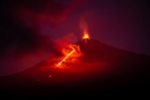
The activity at the level of the eruptive cone located to the south-east of the Enclos Fouqué . is weak with rare lava projections and a flow of lava mainly in tunnels, with resurgences revealing lava flows on the surface up to a altitude of about 1300m. The eruptive cone reached an approximate height of 30 meters this morning.
Shooting of the second crack of the first eruptive site, located to the east of the summit around 1700 m altitude and on which degassing zones persist. Image obtained on July 25, 2023 at 12:16 p.m. local time (08:16 UTC). (©OVPFIPGP).
A reconnaissance on the ground still in progress, shows that a light degassing activity is still present on the cracks opened at the start of the eruption to the east of the summit, but that no new cracks have opened in the sector.
The flow front has not changed since July 5 and is now frozen. It is 1.8 km from the road.
Low inflation of the massif continues, indicating a re-pressurization of the volcano’s feeding system with possible transfer of deep magma to the latter.
The seismic activity recorded under the summit zone remains weak. Thus over the last 24 hours, a single superficial volcano-tectonic earthquake has been recorded. This low seismic activity leads to a decrease in the risk of the appearance of a new crack and / or collapse in the crater, but does not mean that it can be excluded.
Alert level: Alert 2-1 (eruption in the Enclos without any particular threat to the safety of people, property or the environment).
Source : OVPF
Italy / Sicily , Etna :
WEEKLY BULLETIN, from July 17, 2023 to July 23, 2023. (issue date July 25, 2023)
ACTIVITY STATUS SUMMARY
In the light of the monitoring data, it is highlighted:
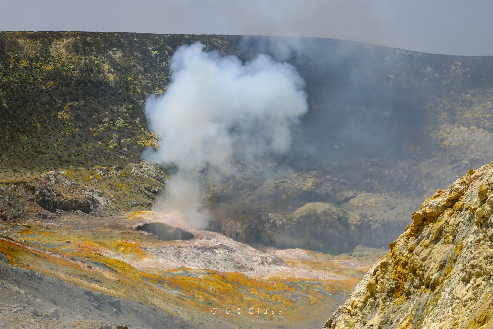
1) VOLCANOLOGICAL OBSERVATIONS: Degassing activity at the level of the summit craters at the level of the Bocca Nuova crater and the Southeast Crater.
2) SEISMOLOGY: Only one earthquake exceeded the local magnitude threshold of 2.0. The average amplitude of the volcanic tremor remained at average values. The locations of the centroids of the sources of the tremor remain in the area of the Southeast crater.
3) INFRASOUND: Decrease in infrasound activity compared to the previous week; the events were located mainly in the Southeast crater area.
4) GROUND DEFORMATIONS: During the last week, the ground deformation monitoring networks have not recorded any significant variations.
5) GEOCHEMISTRY: SO2 flux at an average level.
Soil CO2 flux in average values.
There are no updates since the previous week on the helium isotope ratio.
CO2 dissolved in the Ponteferro drainage tunnel without significant changes.
6) SATELLITE OBSERVATIONS: Thermal activity observed from the satellite has generally been low level with rare and isolated moderate level anomalies.
7) OTHER OBSERVATIONS: As part of the activities of MapLAB (INGV-OE Mapping Laboratory) surveys were carried out in the summit area with the DJI Phantom RTK drone (positioning accuracy of about 2 cm) in the purpose of updating the topography of Etna where there have been changes during the year.
VOLCANOLOGICAL OBSERVATIONS
The monitoring of volcanic activity in the summit craters of Etna during the week was carried out by analyzing the images of the network of surveillance cameras of the INGV section of Catania, Osservatorio Etneo (INGV-OE) and by direct observations on the ground.
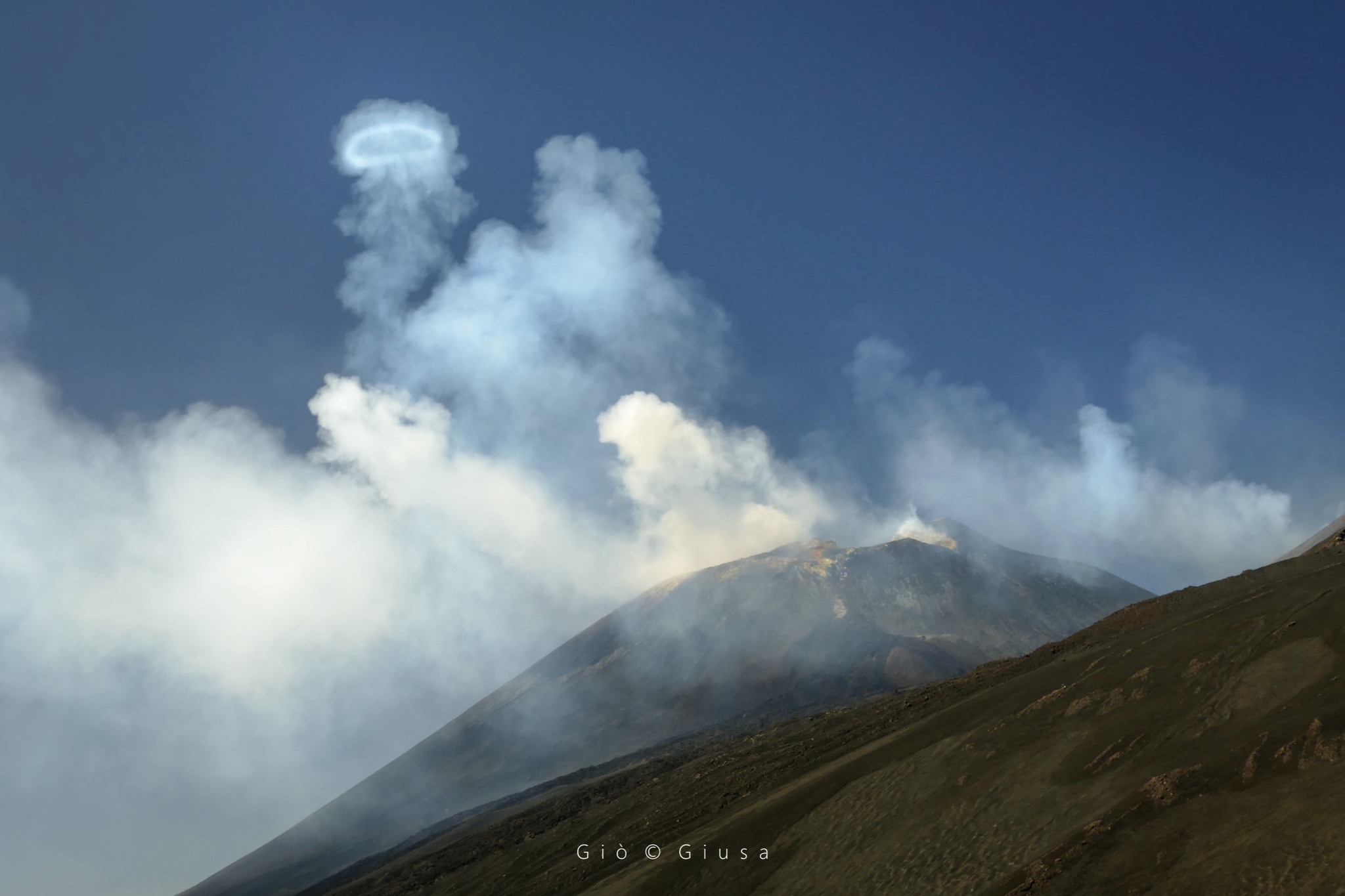
The new « Pit crater » (or collapse crater) that opened at the mouth of 1964 (BN2), which is the one that produces all the rings that can currently be seen on the summit area of the volcano.
In general, both at Bocca Nuova and at the Southeast Crater, intense and continuous impulsive degassing activity was observed during the period in question, often coupled with roars due to pressurized gases and sometimes accompanied flashes visible at night due to their high temperature.
Finally, Voragine still maintains a state of absence of degassing activity while weak fumarolic-type degassing continues to be observed at the level of the Northeast Crater.
Source : INGV.
Photos : Gio Giusa.
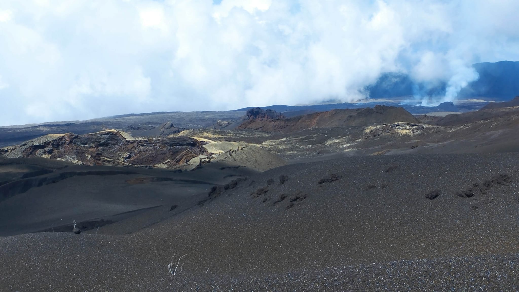
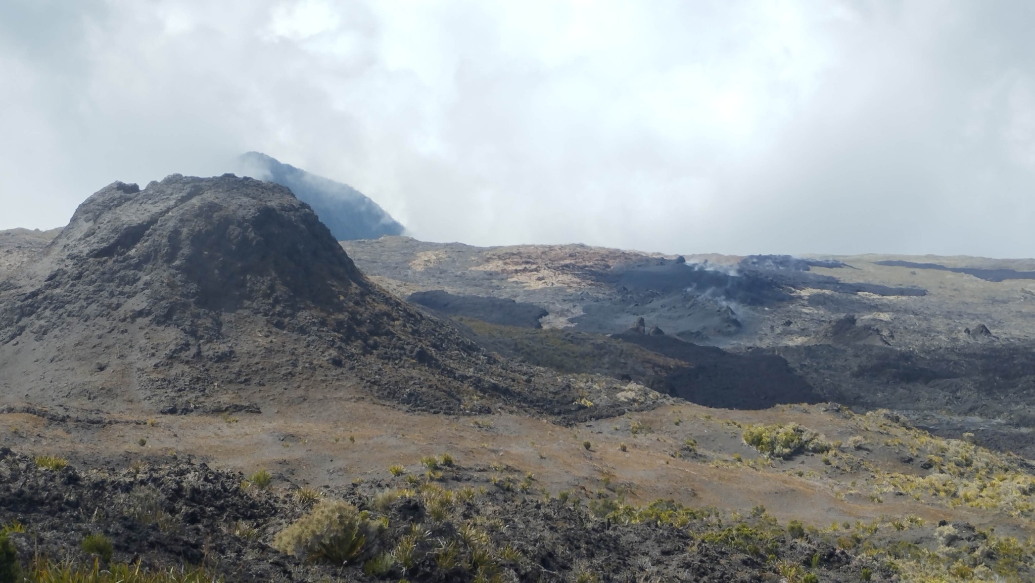
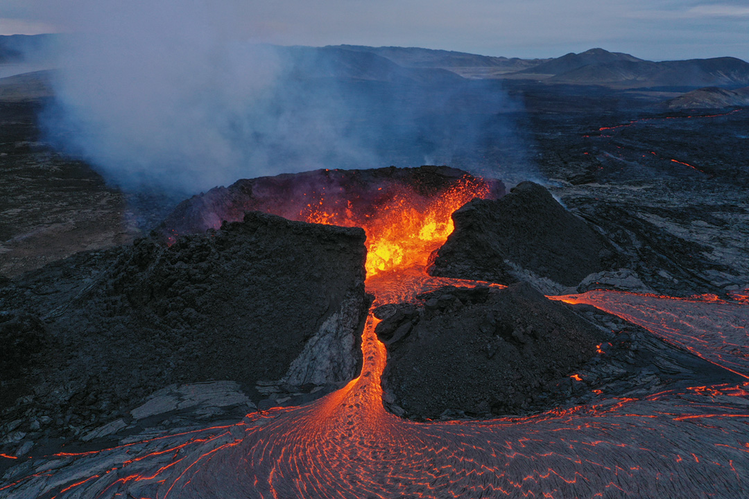
Iceland , Litli Hrútur :
Latest news on the volcanic eruption on the Reykjanes Peninula , Updated 25 July 2023
The map below shows the latest lava field extension in accordance with the data acquired by the University of Iceland, the Icelandic Institute of Natural History and the National Land Survey of Iceland on 23 July. The latest measurement indicates an average effusion rate of 8.0 m3/s for the period 18-23 July. After two weeks of activity, the lava field covers now an area of about 1.2 km2 and the total erupted volume is about 12.4 million cubic meters.
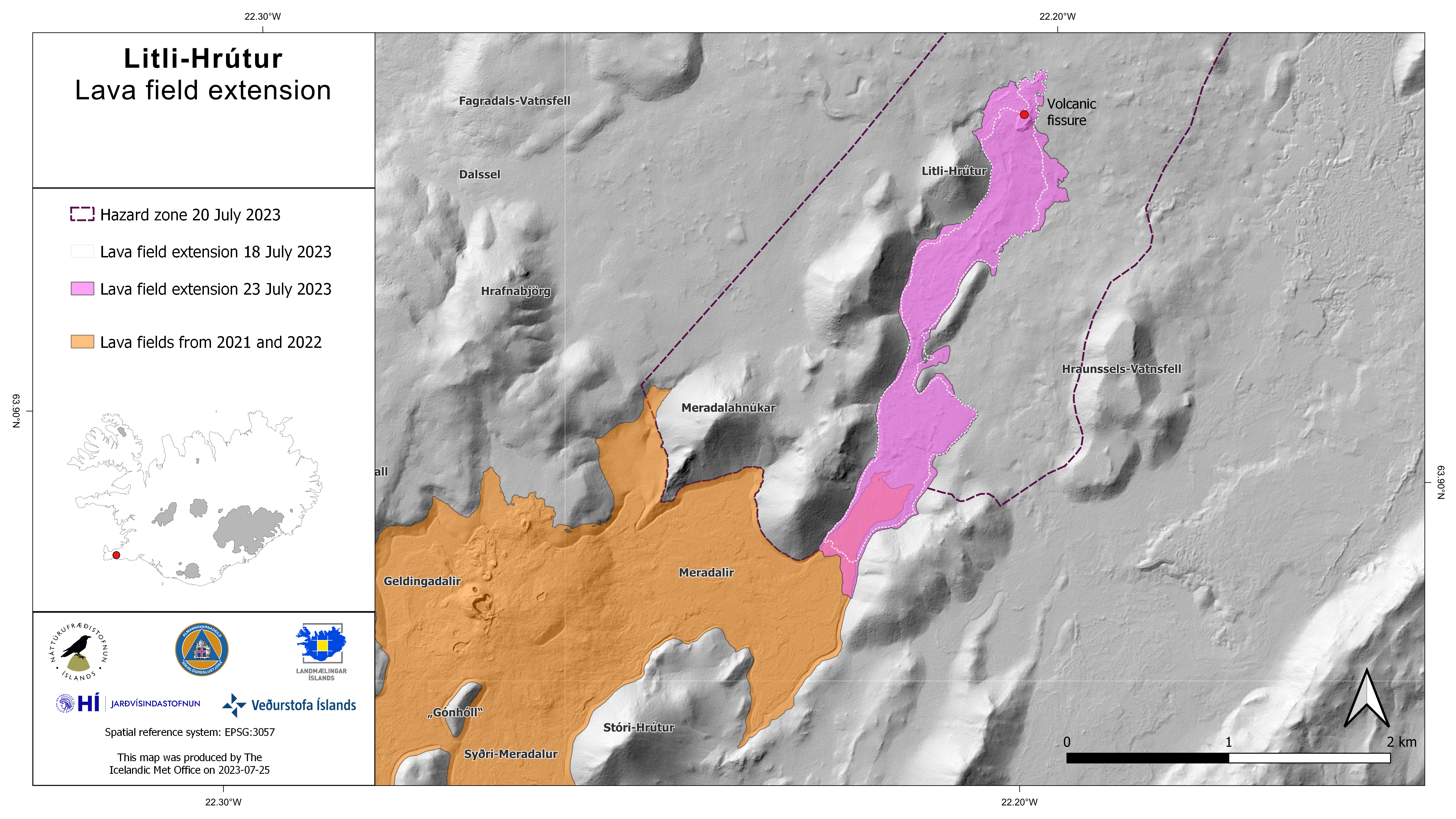
The Icelandic Met Office, in collaboration with the Civil Protection Department of Iceland, has set up a web camera for monitoring the possible lava flow advancement out of Meradalir and further to the South. At least two times the lava flow spread out from the main vent in Litla-Hrút toward other directions, delaying its propagation to the South. At this stage it is difficult to assess if and when lava flow will reach the ridge at the edge of Meradalir.
Lava flow measurements (July 23)
Images were obtained from TF-CAD yesterday afternoon. The Institute of Natural Sciences made a terrain model from the photos. Measurements show that the average lava flow for the past five days (July 18-23) was about 8.0 m3/s.
The lava had reached 1.2 square kilometers and its volume was 12.4 million cubic meters. Lava expansion during this period was mainly eastward. At Meradöl, the lava edge has advanced 200m in the past five days. The progress of the lava towards the South is therefore now very slow.
The measurements confirm the lava flow which slowly decreases over time.
The lava is now a bit larger than what formed in August of last year, and the volume is a bit larger than it was during the 18-day eruption. Compared to the 2021 eruption, the volume is still only 8% of what happened then in six months. These first 13 days were far more powerful than the first weeks of the 2021 eruption.
Chemical composition measurements
Three-day samples (July 10, 13 and 15) were chemically analyzed. There has been no change in the chemical composition of the lava since the start of the eruption at Litla Hrút on July 10, and the lava as before is of a similar type to the lava that was characteristic of the eruption. of 2021 as well as last August.
Sampling organized by the UI Institute of Geosciences will continue and lava samples will be chemically analyzed on a regular basis.
Source : IMO , jardvis.hi.is.
Photos : IMO , Martin Rietze .
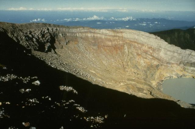
Colombia , Nevado del Ruiz :
Weekly activity bulletin of the Nevado del Ruiz volcano
Regarding the monitoring of the activity of the NEVADO DEL RUIZ VOLCANO, the MINISTRY OF MINES AND ENERGY through the COLOMBIAN GEOLOGICAL SERVICE (SGC) informs that:
In the week of July 18 to 25, 2023, the volcano continued to show instability in its behavior, reflected by low and moderate activity levels and variations, mainly in seismicity.
The seismicity associated with the fracturing of the rock inside the volcanic edifice has increased in the number of earthquakes recorded as well as in the seismic energy released compared to the previous week. The earthquakes were located mainly in the North-West and North-East sectors of the volcano, approximately at an average distance of 7 km and 3 km respectively from the crater and, to a lesser extent, in the Arenas crater, with depths between 1 and 9 km from the summit of the volcano. Since July 20, the increase in this type of seismicity in the two sectors mentioned is notable. However, most earthquakes have been low energy (magnitude less than 1). The maximum magnitude recorded so far is 1.7, corresponding to the earthquake that occurred early today, July 25, at 4:08 a.m. It should be mentioned that low energy seismicity associated with the activity of the lava dome located at the bottom of the crater was also recorded, but to a lesser extent than the previous week.

In parallel, the recording of the seismicity linked to the movement of fluids inside the volcanic conduits continued. This presented similar levels in the number of earthquakes recorded and an increase in seismic energy released, compared to the previous week. The seismic signals showed low to moderate energy levels and several of them were associated with emissions of gas and ash into the atmosphere and/or changes in the relative temperature of the material emitted. Both phenomena were confirmed by conventional and thermographic cameras used to monitor the volcano.
Regarding surface activity, the volcano continued to emit water vapor and gases, mainly sulfur dioxide. The maximum height of the vertical column of gas was 1,200 meters above the summit of the volcano on July 24. In dispersion, the column presented heights greater than 1800 meters, recorded on July 24 and 25. The direction of dispersion of the column showed a preferential tendency towards the North-West and West-North-West of the volcanic structure, which repeatedly caused slight ash falls in Manizales.
Source et photo : SGC
Indonesia , Dempo :
An eruption of G. Dempo occurred on Tuesday, July 25, 2023 at 9:15 p.m. WIB. The height of the eruptive column was observed at ± 2000 m above the summit (± 5173 m above sea level). The ash column was white to gray with moderate to thick intensity, oriented to the south and southwest. The eruption was recorded on a seismograph with a maximum amplitude of 35 mm and a duration of 204 seconds.
VOLCANO OBSERVATORY NOTICE FOR AVIATION – VONA
Issued : July 26 , 2023
Volcano : Dempo (261230)
Current Aviation Colour Code : YELLOW
Previous Aviation Colour Code : unassigned
Source : Dempo Volcano Observatory
Notice Number : 2023DEM001
Volcano Location : S 04 deg 01 min 48 sec E 103 deg 07 min 48 sec
Area : South Sumatra, Indonesia
Summit Elevation : 10154 FT (3173 M)
Volcanic Activity Summary :
Increasing in volcanic activity.
Volcanic Cloud Height :
Best estimate of ash-cloud top is around 16554 FT (5173 M) above sea level or 6400 FT (2000 M) above summit. May be higher than what can be observed clearly. Source of height data: ground observer.
Other Volcanic Cloud Information :
Ash cloud moving from south to southwest. Volcanic ash is observed to be white to gray. The intensity of volcanic ash is observed from medium to thick.
Remarks :
Eruption recorded on seismogram with maximum amplitude 35 mm and maximum duration 204 second. Tremor recorded on seismogram with maximum amplitude 3 mm.
Dempo is a stratovolcano that rises above the Pasumah Plain of SE Sumatra. The andesitic complex has two main peaks, Gunung Dempo and Gunung Marapi, constructed near the SE rim of a 3-km-wide amphitheater open to the north. The high point of the older Gunung Dempo crater rim is slightly lower, and lies at the SE end of the summit complex. The taller Marapi cone was constructed within the older crater. Remnants of seven craters are found at or near the summit, with volcanism migrating WNW over time. The active 750 x 1,100 m active crater cuts the NW side of the Marapi cone and contains a 400-m-wide lake at the far NW end. Eruptions recorded since 1817 have been small-to-moderate explosions that produced local ashfall.
Source : Magma Indonésie , GVP.
Photo : Ruska Hadian, 1989 (Observatoire volcanologique d’Indonésie).