July 24 , 2023.
Alaska , Shishaldin :
AVO/USGS Volcanic Activity Notice
Current Volcano Alert Level: WARNING
Previous Volcano Alert Level: WATCH
Current Aviation Color Code: RED
Previous Aviation Color Code: ORANGE
Issued: Saturday, July 22, 2023, 11:43 PM AKDT
Source: Alaska Volcano Observatory
Notice Number: 2023/A1122
Location: N 54 deg 45 min W 163 deg 58 min
Elevation: 9373 ft (2857 m)
Area: Aleutians
Volcanic Activity Summary:
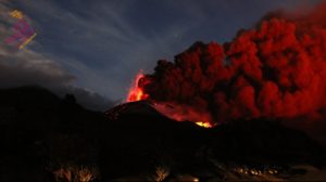
An ash cloud from Shishaldin Volcano reaching 30,000 ft. (9 km) was observed in satellite data and pilot reports at 11:30 pm AKDT (07:30 UTC on July 23). This follows a several-hour increase in observed eruptive activity. In response, the aviation Color Code is being raised to RED and the Volcano Alert Level is being raised to WARNING. The National Weather Service has issued a SIGMET for this ash cloud, and a Special Weather Statement has been issued for possible trace ash on False Pass.

Based on previous eruption cycles, significant ash emissions are likely to continue for an hour or more. Pyroclastic and mudflows are likely on the immediate flanks of the volcano.
Shishaldin Volcano is monitored by local seismic and infrasound sensors, web cameras, and a telemetered geodetic network. The local monitoring network has been partially impaired over the last few weeks due to telecommunications issues but seismic stations and web cameras south of the volcano were brought back online on July 19. In addition to the local monitoring network, AVO uses nearby geophysical networks, regional infrasound and lighting data, and satellite images to detect eruptions.
Hazard Analysis:
[Ash cloud] 30,000 ft. (9 km) above sea level moving northeast, see SIGMET
AVO/USGS Volcanic Activity Notice
Current Volcano Alert Level: WATCH
Current Aviation Color Code: ORANGE
Issued: Sunday, July 23, 2023, 4:18 AM AKDT
Volcanic Activity Summary:
Volcanic activity has significantly declined at Shishaldin Volcano. Seismic tremor began declining from a peak at 12:30 am AKDT (08:30 UTC) and is and is currently at low levels. Significant ash eruption notably decreased in satellite data around 1:30 am (09:30 UTC). Satellite data continue to indicate elevated surface temperatures at the summit associated with lava erupting at the surface and possible low-level ash emissions below regional cloud tops which are currently at around 20,000 ft. (6 km) above sea level.
A sustained ash plume with a height of 37,000 ft. (11 km) above sea level erupted between 11:20 pm AKDT on July 22 (07:20 UTC on July 23) and 12:30 am on July 23 (08:30 UTC on July 23). Around this time plume height decreased to around 15,000 ft. (4.5 km) above sea level.
A detached plume is currently drifting to the northeast along the Alaska Peninsula. The National Weather Service has issued a SIGMET for this ash cloud, as well as a Marine Weather Statement and an Ashfall Advisory that were issued for areas that might expect ashfall associated with this eruption.
Recent Observations:
[Volcanic cloud height] unknown, below 20,000 ft. (6 km) above sea level
[Other volcanic cloud information] Main eruption cloud detached and drifting to the northeast, see current NWS SIGMET.
Hazard Analysis:
[Ashfall] Trace ashfall possible downwind of the volcano, see Special Weather Statement
[Pyroclastic flow] Likely on all flanks
[Mud flow] Likely on all flanks
Source : AVO
Photos : Nick Enloe , Woodsen Saunders , avo ( Archives)
La Réunion , Piton de la Fournaise :
Press release from the Paris Institute of Earth Physics, Piton de la Fournaise Volcanological Observatory. July 23, 2023 – 2:30 p.m. – 10:30 a.m. UTC
Ongoing eruption
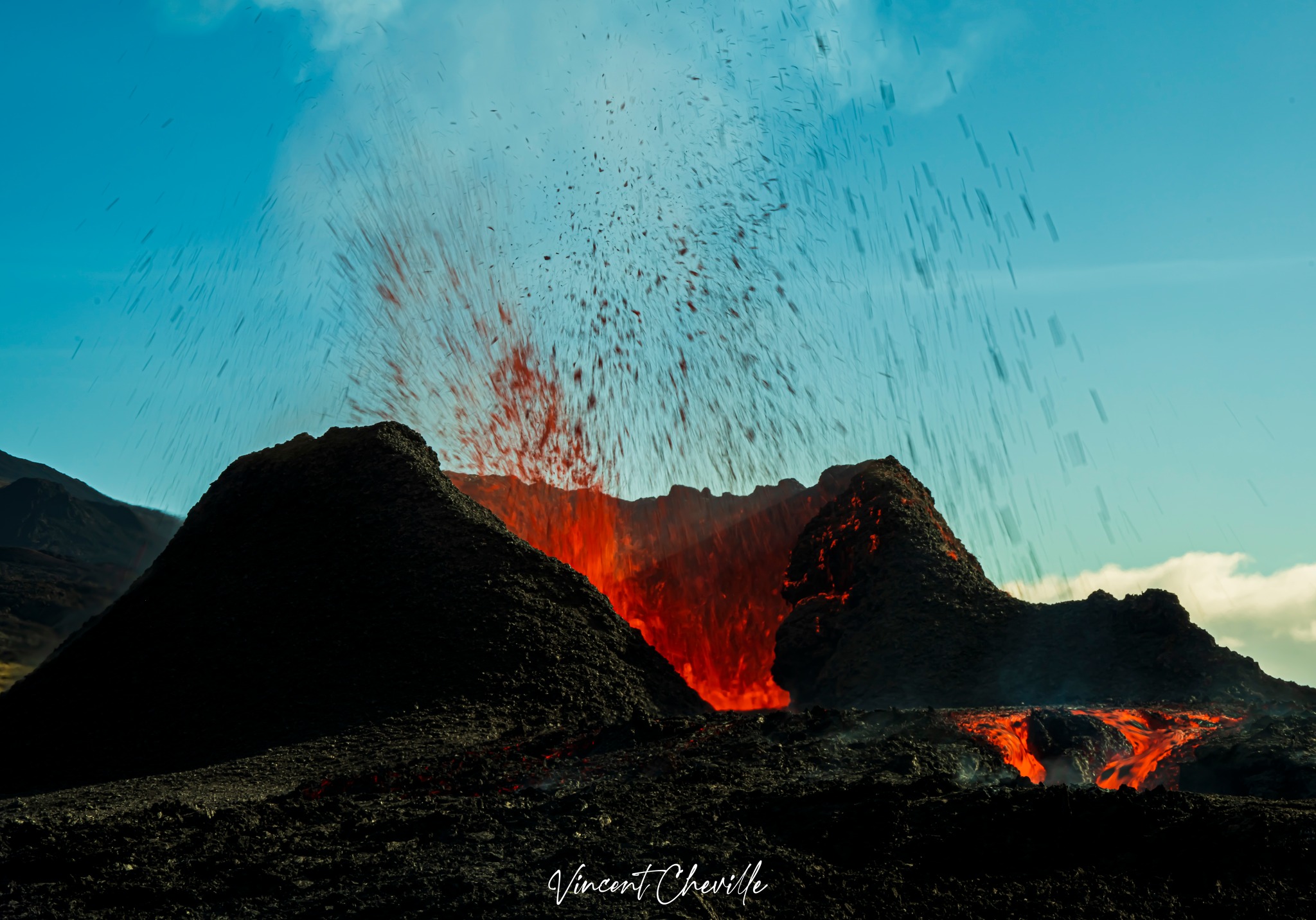
The eruption which began on July 02, 2023, around 08:30 local time continues. The amplitude of the volcanic tremor (indicator of an emission of lava and gas on the surface) remains very low compared to the start of the eruption.
The amplitude of the seismic signals showed an increase this morning (between 9:30 a.m. and 11 a.m. local time) on the OVPF stations located north of the Enclosure. This increase could indicate that eruptive or degassing activity resumed between 9:30 a.m. and 11 a.m. local time, on the first fissures opened on July 2, 2023.
Given the poor weather conditions on site, no visual confirmation could be made today concerning the nature of this increase in amplitude of the tremor (new crack, resumption of activity on the North cracks opened on the 1st day of the eruption, or simple degassing in the North zone).
Given the persistent bad weather conditions currently on site:
– no visual feedback on the eruptive site and the lava field could be made today and tonight,
– nor any estimate of lava flows by satellite method.
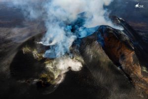
The flow front has not changed since July 5 and is now frozen. It is still 1.8 km from the road.
Low inflation of the summit area is still recorded, indicating a re-pressurization of the volcano’s feeder system with possible transfer of deep magma to the latter.
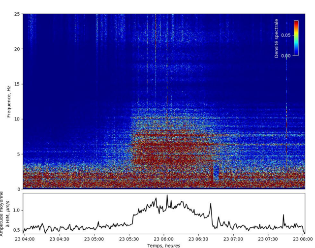
Seismological data at the HIM station on July 23, 2023 between 4 a.m. and 8 a.m. UTC (8 a.m. and 12 p.m. local time). Top: spectrogram showing the evolution of the frequency content of the data. Bottom: Average seismic amplitude in a 40-second sliding window. There is an increase in the seismic amplitude and a change in the frequency content of the data between 5:30 a.m. and 7:00 a.m. UTC (9:30 a.m. and 11 a.m. local time (©OVPF-IPGP).
The seismic activity recorded under the summit zone remains weak. Thus over the last 24 hours, a single superficial volcanotectonic earthquake has been recorded. This low seismic activity leads to a reduction in the risk of the appearance of a new crack and/or collapse in the crater, but does not mean that it can be excluded, as shown by the variations in amplitude in the tremor as well as the continuation of the summit inflation.
Alert level: Alert 2-1 (eruption in the Enclos without any particular threat to the safety of people, property or the environment).
Source : OVPF
Photos : Volcanoexplorer.re Tunnels de lave Réunion/Vincent Cheville, OVPF.
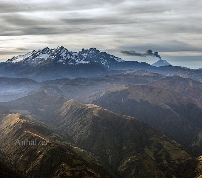
Ecuador , Sangay :
DAILY REPORT OF THE STATE OF SANGAY VOLCANO, Sunday July 23, 2023.
Information Geophysical Institute – EPN.
Surface Activity Level: High, Surface Trend: Unchanged
Internal activity level: High, Internal trend: No change
Seismicity: From July 22, 2023, 11:00 a.m. to July 23, 2023, 11:00 a.m.:
The number of seismic events recorded at the reference station over the past 24 hours is shown below. The level of seismic activity of the volcano remains high.
Explosion Event (EXP): 481.
Emission / Ash Column:
The satellite observed, during the last 24 hours, narrow plumes with low ash content, at an approximate height of 900 m above the level of the crater and in a northwest and west direction.
Gas:
According to satellite images, 56 tons of SO2 have been detected in the atmosphere (MOUNTS report – July 22 at 13:03 TL).
Rains / Lahars:
With the surveillance camera, the occurrence of rains in the area was observed. Heavy rains could remobilize accumulated materials, generating mudslides and debris that would descend the flanks of the volcano and flow into rivers downstream.
Observation:
The volcano remained mostly cloudy, but last night incandescence could be observed in the crater for brief moments.
Alert level: Orange.
Source : IGEPN.
Photo : Jorge Anhalzer
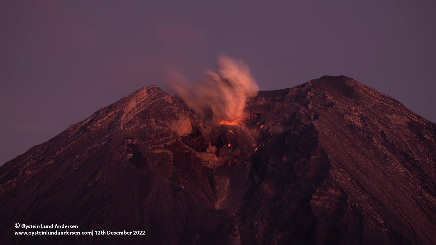
Indonesia , Semeru :
VOLCANO OBSERVATORY NOTICE FOR AVIATION – VONA
Issued : July 24 , 2023 .
Volcano : Semeru (263300)
Current Aviation Colour Code : ORANGE
Previous Aviation Colour Code : orange
Source : Semeru Volcano Observatory
Notice Number : 2023SMR238
Volcano Location : S 08 deg 06 min 29 sec E 112 deg 55 min 12 sec
Area : East java, Indonesia
Summit Elevation : 11763 FT (3676 M)
Volcanic Activity Summary :
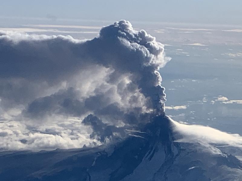
Eruption with volcanic ash cloud at 00h10 UTC (07h10 local).
Volcanic Cloud Height :
Best estimate of ash-cloud top is around 14323 FT (4476 M) above sea level or 2560 FT (800 M) above summit. May be higher than what can be observed clearly. Source of height data: ground observer.
Other Volcanic Cloud Information :
Ash cloud moving from north to northwest. Volcanic ash is observed to be white to gray. The intensity of volcanic ash is observed to be thick.
Remarks :
Eruption recorded on seismogram with maximum amplitude 21 mm and maximum duration 98 second.
Source : Magma Indonésie .
Photo : Oystein Lund Andersen .
Costa Rica , Rincon de la Vieja / Poas / Turrialba :
Daily report on the state of volcanoes. Date: July 23, 2023.
Updated at: 11:10:00.
Rincon de la Vieja Volcano
Latitude: 10.83
Longitude:-85.324
Altitude: 1,916 meters
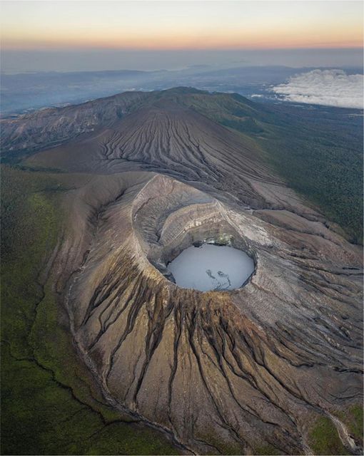
Observed activity:
In the past 24 hours, there have been 4 rather small exhalations of steam and gas in the Rincón crater with weak seismic signals recorded. The seismic activity continues to be dominated by an almost continuous volcanic tremor with frequencies between 1 and 6 Hz and with a tendency to decrease in amplitude. No volcanic earthquake of type LP (fluid movement) or VT (rock rupture) was recorded.
Environmental conditions:
Air masses are transported westward and there are partly cloudy conditions at the top of the volcano.
Activity Level: Attention (3)
Poas Volcano
Latitude: 10.2
Longitude:-84.233
Altitude: 2,687 meters
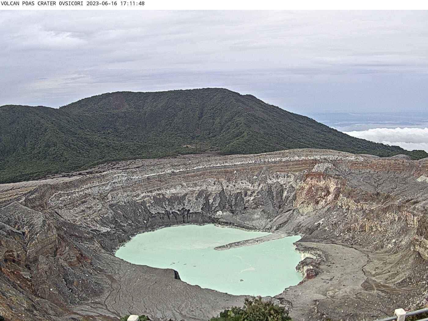
Observed activity:
There are no phreatic eruptions. The volcanic tremor is recorded on the seismographs as an interrupted and very weak signal tending to disappear. The convection cell in the center of the hyperacidic lake has disappeared, indicating that the underwater fumarole has lost strength. The lake shows its usual pale milky green color. Frequent low-frequency, low-amplitude LP-type volcanic earthquakes associated with fluid transport within the volcano continue to be recorded. The fumaroles in the East and Southeast sector of the active crater continue with a weak flow of steam and heat. SO2 gas concentrations at El Mirador para Visitantes remain below 1.5 parts per million according to data from the ExpoGAS gas detection system.
Environmental conditions:
The air masses are transported to the southwest and the summit is clear.
Activity Level: Warning (2)
Turrialba Volcano
Latitude: 10.025
Longitude:-83.767
Altitude: 3,325 meters
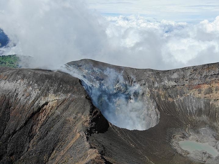
Observed activity:
There are no volcanic eruptions or tremors. A moderate amount of low frequency, low amplitude LP type volcanic earthquakes associated with fumarolic degassing is recorded. The fumaroles around the West Crater are maintained with moderate gas flow and heat. The MultiGAS gas detector near the West crater records a low concentration of SO2 = 2 parts per million and a stable CO2/SO2 ratio around 15. The atmospheric dust (aerosol) and gas sensors of the OVSICORI-UNA volcanic gas and aerosol monitoring station located in Coronado, 25 km west of the Turrialba volcano, continue to show very low concentrations in the ambient air this week, which is consistent with the weak gasification and the activity of the Turrialba volcano: SO2max = 0.7 parts per billion.
Environmental conditions:
The winds are blowing northwest and the summit is cloudy.
Activity Level: Warning (2)
Source : Ovsicori.
Photos : Soy Tico , Ovsicori , G. Avard / Ovsicori.