July 17 , 2023.
La Réunion , Piton de la Fournaise :
Press release from the Paris Institute of Earth Physics, Piton de la Fournaise Volcanological Observatory, July 17, 2023 – 10:30 a.m. – 06:30 a.m. UTC
Ongoing eruption
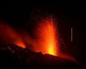
The eruption which began on July 02, 2023, around 08:30 local time continues. The amplitude of the volcanic tremor (indicator of an emission of lava and gas on the surface) is always fluctuating over time on the scale of a few tens of minutes, with phases of continuous tremor and phases of intermittent tremor. The amplitude of the tremor nevertheless remains low compared to the start of the eruption and shows a new downward trend for 5 days.
The fluctuations observed in the tremor are reflected at the level of the eruptive site by variations in intensity in the activity, with projections of lava fountains at the level of the more or less intense eruptive cone.
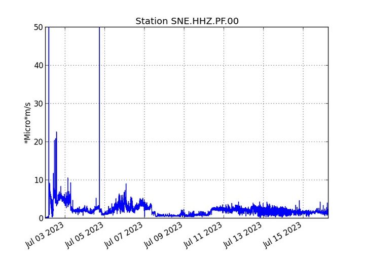
Evolution of the RSAM and the amplitude of the tremor (indicator of an emission of lava and gas on the surface) since 07/02/2022 00:00 UTC time (04:00 local time) on the SNE seismological station located at the top of the volcano ( © OVPF-IPGP)
Thanks to milder weather conditions on the volcano, lava flow estimates could be calculated by satellite method on the HOTVOLC platform (OPGC – Clermont Auvergne University). During the last 12h the flows were between <1 and 4.3 m3/sec. Given the cloud mass present regularly on the eruptive site as well as the presence of lava tunnels, these flows may be underestimated.
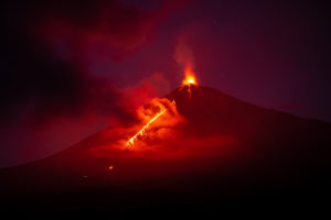
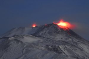
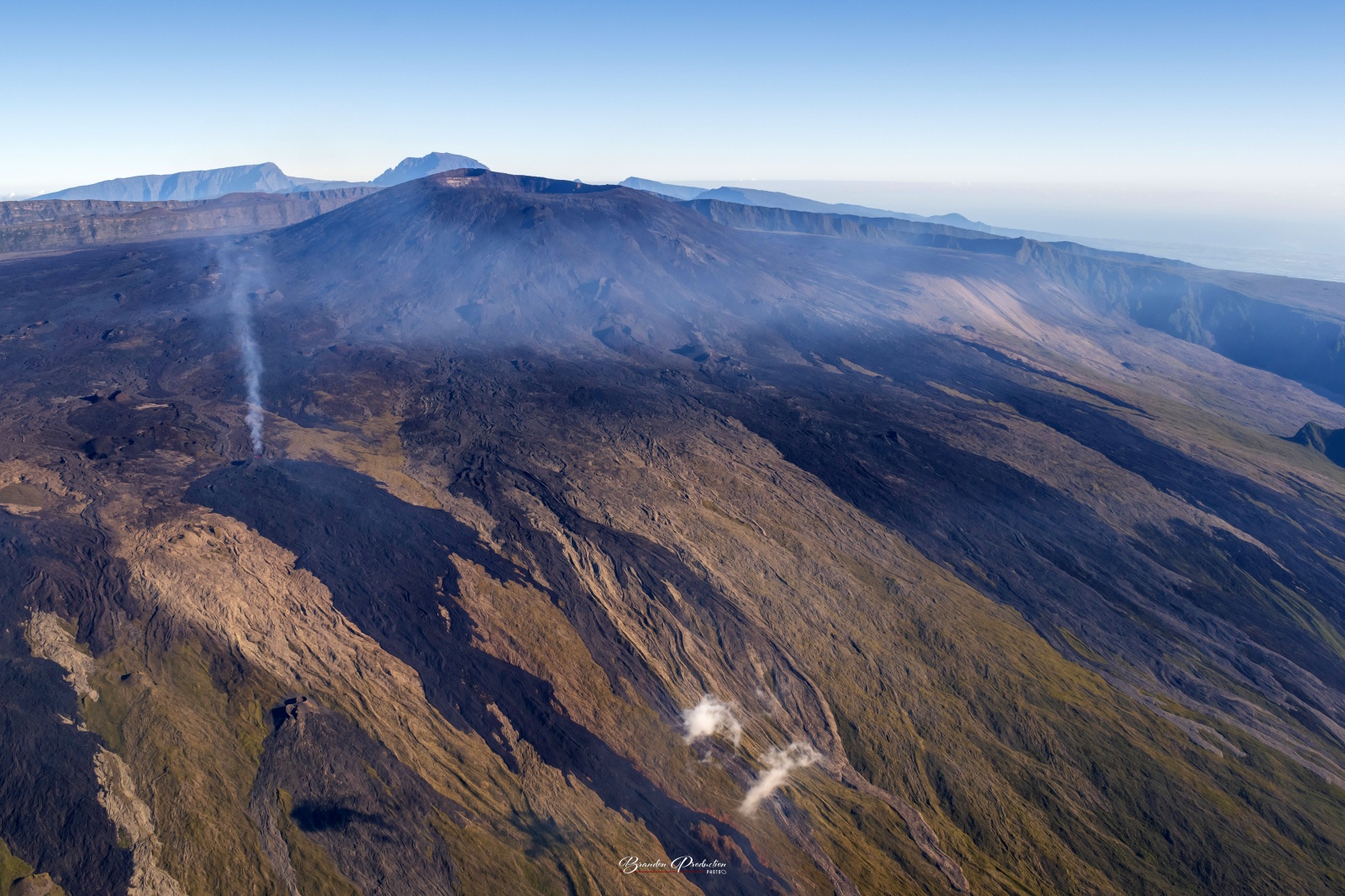
The morphology of the active volcanic cone – located southeast of the Enclos Fouqué at an altitude of 1720 m – has hardly changed since the images of July 13 in the morning.
The lava flow now takes place mainly in lava tunnels in the immediate vicinity of the cone, even if flows are still visible at resurgence points.
Currently the growth of the lava field is mainly by widening and thickening near the eruptive cone at the level of the lava tunnel networks.
During last night, the active flows were still at altitudes above 1500 m in the upper part of the Grandes Pentes.
The flow front has not changed since July 5 and is still 1.8 km from the road.
A resumption of inflation in the summit area seems to be taking shape. This parameter will be confirmed in the coming days. It could be an indicator of a deep magma transfer to the superficial feeding system.
The seismic activity recorded under the summit zone remains weak. Thus over the last 24 hours, two superficial volcano-tectonic earthquakes have been recorded. This low seismic activity leads to a reduction in the risk of the appearance of a new crack and/or collapse in the crater, but does not mean that it can be excluded.
Alert level: Alert 2-1 (eruption in the Enclos without any particular threat to the safety of people, property or the environment)
Source : OVPF
Photo : Imaz press / Brandon production.
Iceland , Litli Hrútur :
Reykjanes Eruption Site Remains Closed
The Reykjanes eruption site remains closed today, July 17, following a meeting of The Department of Civil Protection and Emergency Management and local authorities. However, the decision will be reconsidered today at 1:00 PM.
The decision to close the site was made July 13 and it remained closed over the weekend.
Smoke from wildfires obscured the hiking trails to the eruption site, in addition to posing a health risk. Under these circumstances, local authorities could not guarantee the safety of those entering the area.
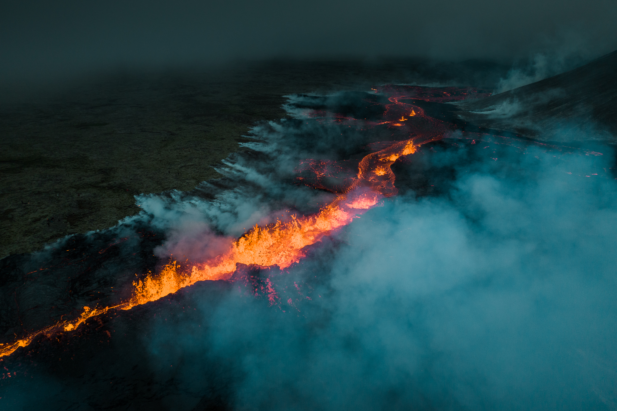
Efforts are now being made to extinguish the wildfires northeast of Keilir towards the viewpoint at Hraunsels-Vatnsfell. Police also report that the Coast Guard helicopter is on its way to assist in the firefighting operation.
Despite the area being closed, search and rescue teams had to search for two travellers last night. A man in his forties was found on Höskuldarvallavegur at 6:00 A, and a woman was found east of Keilir at 3:00 AM. Gas plumes can be seen blowing over the hiking trail, in addition to smoke from the wildfires.
Source : icelandreview.com
Photo : Garðar Ólafsson
Philippines , Mayon :
MAYON VOLCANO BULLETIN 18 July 2023 8:00 AM
In the past 24-hour period, very slow effusion of lava from the summit crater of Mayon Volcano continued to feed lava flows and collapse debris on the Mi-isi (south) and Bonga (southeastern) gullies as well as rockfall and PDCs on these and the Basud (eastern) gullies. The lava flows from the summit crater have advanced to approximate lengths of two thousand eight hundred (2800) meters along Mi-isi gully, two thousand four hundred (2400) meters along Bonga gully, and six hundred (600) meters along Basud gully. Meanwhile, collapse debris has deposited to four thousand (4000) meters from the crater along the Basud channel. Three (3) pyroclastic density currents (PDC) generated by dome-collapse, one hundred fifty (150) rockfall events, and two hundred sixty-seven (267) volcanic earthquakes were recorded by the Mayon Volcano Network.
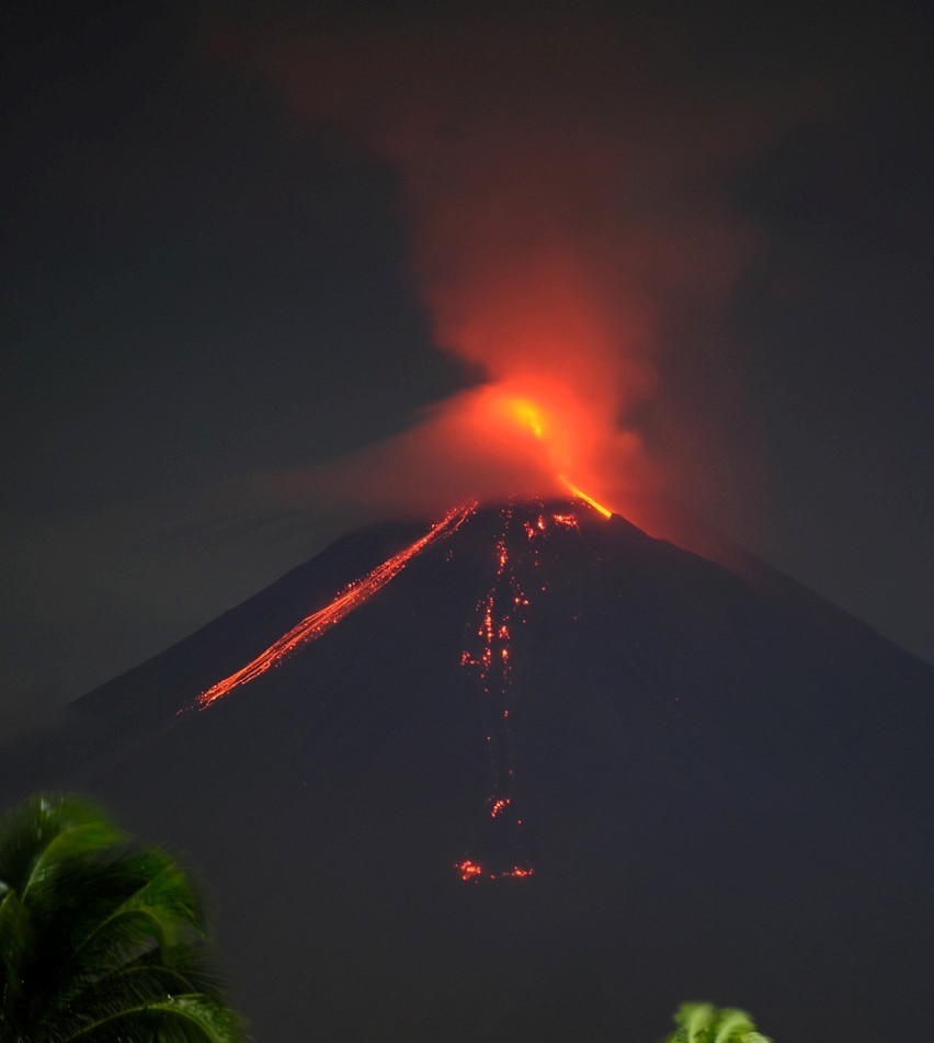
Repetitive pulse tremor reoccurred at 11:00PM 16 July 2023 with varying interval, and accompanying infrasonic signals detected with reported audible sounds. Sulfur dioxide (SO2) emission averaged 2,212 tonnes/day on 17 July 2023. Short-term observations from EDM and electronic tiltmeter monitoring show the upper slopes to be inflating since February 2023. Longer-term ground deformation parameters based on EDM, precise leveling, continuous GPS, and electronic tilt monitoring indicate that Mayon is still inflated, especially on the northwest and southeast.
Alert Level 3 is maintained over Mayon Volcano, which means that it is currently in a relatively high level of unrest and hazardous eruption within weeks or even days could still be possible.
Source : Phivolcs
Photo : Dex Baldon
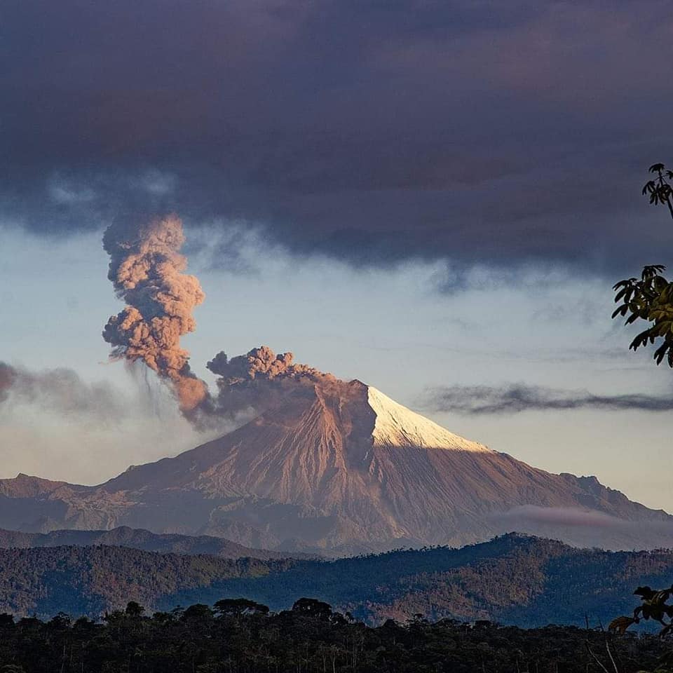
Ecuador , Sangay :
DAILY REPORT OF THE STATE OF SANGAY VOLCANO, Monday July 17, 2023.
Information Geophysical Institute – EPN.
Surface Activity Level: High, Surface Trend: Unchanged
Internal activity level: High, Internal trend: No change
Seismicity: From July 16, 2023, 11:00 a.m. to July 17, 2023, 11:00 a.m.:
Below is the count of seismic events recorded by the reference station over the past 24 hours.
Explosion Event (EXP): 516.
Rains / Lahars:
Rains were recorded yesterday afternoon and in the morning of today in the area of the volcano without generating mudslides and debris. “In the event of heavy rains, these could remobilize the accumulated materials, generating mudslides and debris that would descend the flanks of the volcano and pour into the adjacent rivers.
Emission / Ash Column:
Due to the cloudiness in the area of the volcano, there are no direct observations towards the crater, however, yesterday afternoon thanks to GOES-16 satellite images, a plume of gas and ash was observed. heading west.
Gas:
The MOUNTS system recorded 168.7 tons of sulfur dioxide (SO2), measured on 2023-07-16 at 1:17 p.m. TL.
Other Monitoring Parameters:
The FIRMS satellite system records 1 thermal alert in the last 24 hours.
Observation:
Climatic conditions in the volcano area do not allow observation of surface activity.
Alert level: Orange.
Source : IGEPN.
Photo : volcan sangay FB.
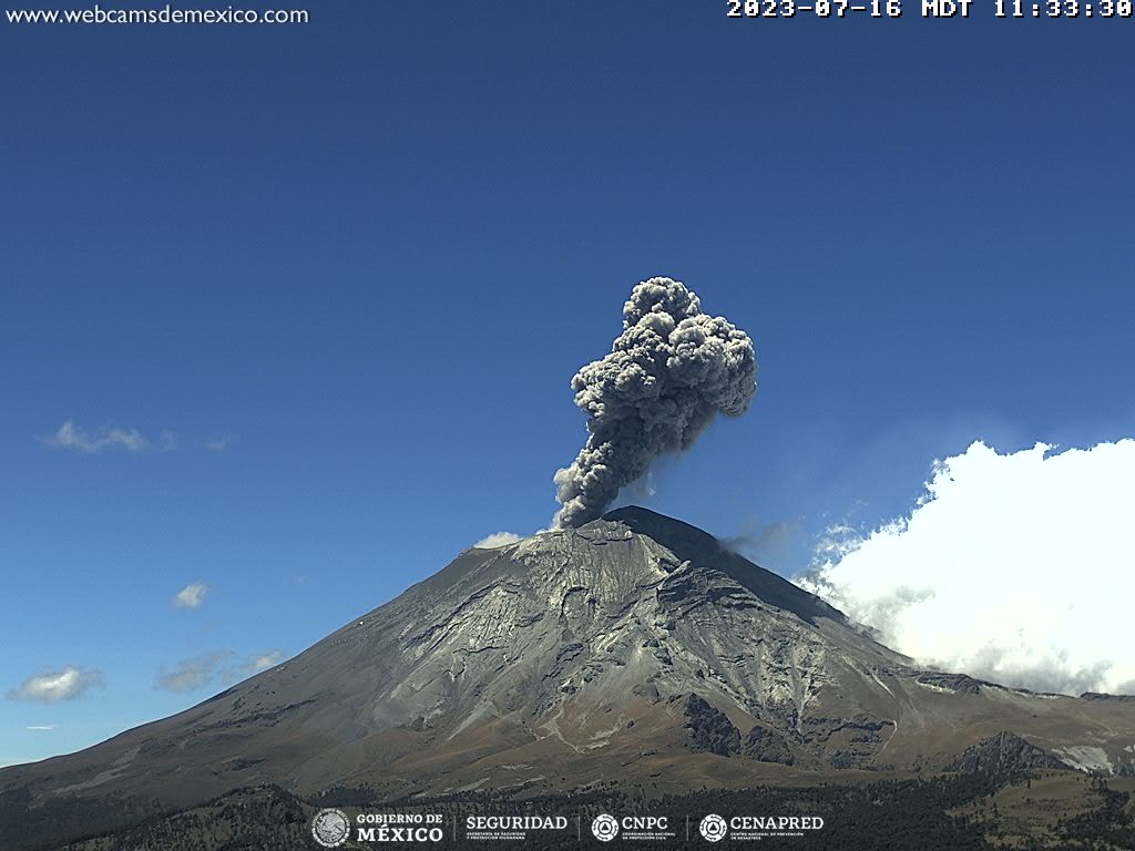
Mexico , Popocatepetl :
July 17, 11:00 a.m. (July 17, 5:00 p.m. GMT)
Activity in the last 24 hours
108 exhalations were detected, accompanied by water vapor, volcanic gases and, sometimes, slight amounts of ash. Additionally, 21 minutes of high frequency, low to medium amplitude tremor was recorded.
During the morning and at the time of this report, there is partial visibility on the volcano, due to weather conditions in the region.
The Popocatépetl Volcanic Warning Traffic Light is located in Phase 2 Amarillo.
The scenarios planned for this phase are:
Some minor to moderate explosions
Occurrence of tremors of varying amplitudes
Light to moderate ash fall in surrounding towns and some more distant towns
Ejection of glowing fragments within the 12 kilometer exclusion radius
We could expect the appearance of lahars descending through the ravines, due to the accumulation of ash on the slopes and its interaction with the rains expected in the coming weeks.
Possibility of pyroclastic flows not reaching the populations.
Source et photo : Cenapred.