July 13 , 2023.
La Réunion , Piton de la Fournaise :
Press release from the Paris Institute of Earth Physics, Piton de la Fournaise Volcanological Observatory. July 12, 2023 – 1:30 p.m. – 9:30 a.m. UTC
Ongoing eruption
The eruption started on 02/07/2023, around 08:30 local time continues. The amplitude of the volcanic tremor (indicator of an emission of lava and gas on the surface) fluctuates over time on the scale of a few hours with phases of continuous tremor and phases of intermittent tremor, but remains low compared to at the start of the eruption. This is reflected at the level of the eruptive site by fluctuations in activity, with projections of lava fountains at the level of the more or less intense eruptive cone.
Lava flow estimates established by satellite method on the HOTVOLC platform (OPGC – Clermont Auvergne University) over the past 24 hours indicated flows between 1 and 13.5 m3 / sec. Given the mass of clouds regularly present on the eruptive site as well as the presence of lava tunnels, these flows may be underestimated.
The active volcanic cone – located southeast of the Enclos Fouqué at an altitude of 1720 m – continues to build by accumulating lava projections.
The lava flow now takes place partly in a lava tunnel in the immediate vicinity of the cone being built, even if flows are still visible. During the last 24 hours, the summit part of the eruptive cone has partially and gradually closed.
At the end of last night, the active flows were at altitudes above 1500 m in the upper part of the Grandes Pentes.
The flow front has not changed since July 5 and is still 1.8 km from the road.
At present, no significant deformation of the building is recorded.
The seismic activity recorded below the summit area has almost ceased. Thus over the last 24 hours, 1 single superficial volcano-tectonic earthquake has been recorded. This very low level of seismic activity leads to a reduction in the risk of the appearance of a new crack and/or collapse in the crater, but does not mean that it can be excluded.
Alert level: Alert 2-1 (eruption in the Enclos without any particular threat to the safety of people, property or the environment).
Source : OVPF
Photo : Volcanoexplorer.re Tunnels de lave Réunion / Vincent Cheville .
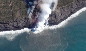
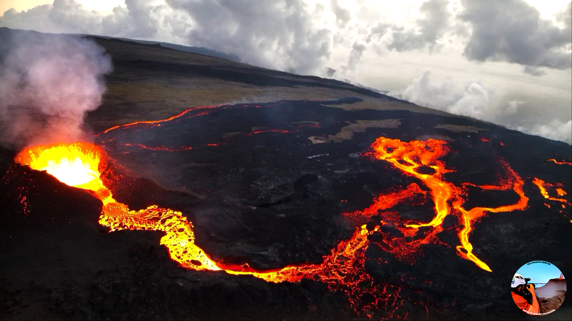
Iceland , Litli Hrútur :
Icelandic Meteorological Office (IMO) reported that a new fissure eruption in the Fagradalsfjall volcanic system began on 10 July after intensifying seismicity over the previous month and inflation that was first noted in April. At 10h55 on 5 July IMO raised the Aviation Color Code to Orange (the third level on a four-color scale). By 13h30 on 7 July there had been more than 7,000 earthquakes detected in the swarm that began on 3 July. Epicenters were aligned NE-SW between Fagradalsfjall and the Keilir cone, NNE from the 2021 and 2022 eruptions, and mostly concentrated just N of the Litli Hrútur hill. Deformation data (GPS and radar interferometry) showed uplift in the same area, suggesting a magmatic dike intrusion that reached to 1 km depth by early on 6 July. Seismicity decreased during 6-7 July and the rate of deformation slowed, with analysis showing that by 9-10 July the dike had propagated 1 km further NE.
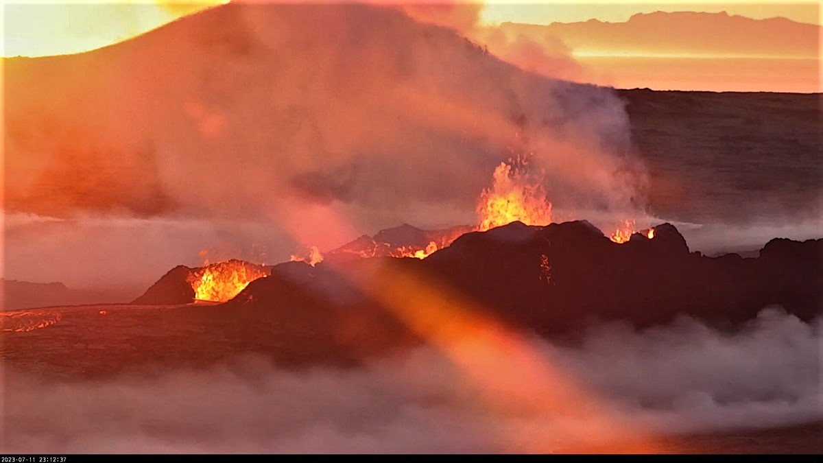
Tremor was detected at 14h25 on 10 July and continued to intensify, leading to an eruption at 16h40 just NW of Litli-Hrútur. Webcam images showed visible gas emissions and incandescence, but no major ash emissions. IMO raised the Aviation Color Code to Red (the highest level on a four-color scale) at 17h07. Flowing lava from a NE-SW fissure that was about 200 m long was confirmed by people present in the area and webcam images; at 17h24 the Aviation Color Code was lowered back to Orange. The fissure was mainly located in a depression and bisected the E and NE flanks of Litli Hrútur. Based on observations from drone video the fissure quickly reached about 900 m long according to estimates from Institute of Earth Sciences. Lava fountaining occurred along the fissure, sending lava flows S. Gas-and-steam emissions drifted NW. According to Almannavarnadeild ríkislögreglustjóra, the police closed the area around the eruption to tourists due to the high concentrations of volcanic gases and particulates from burning vegetation.
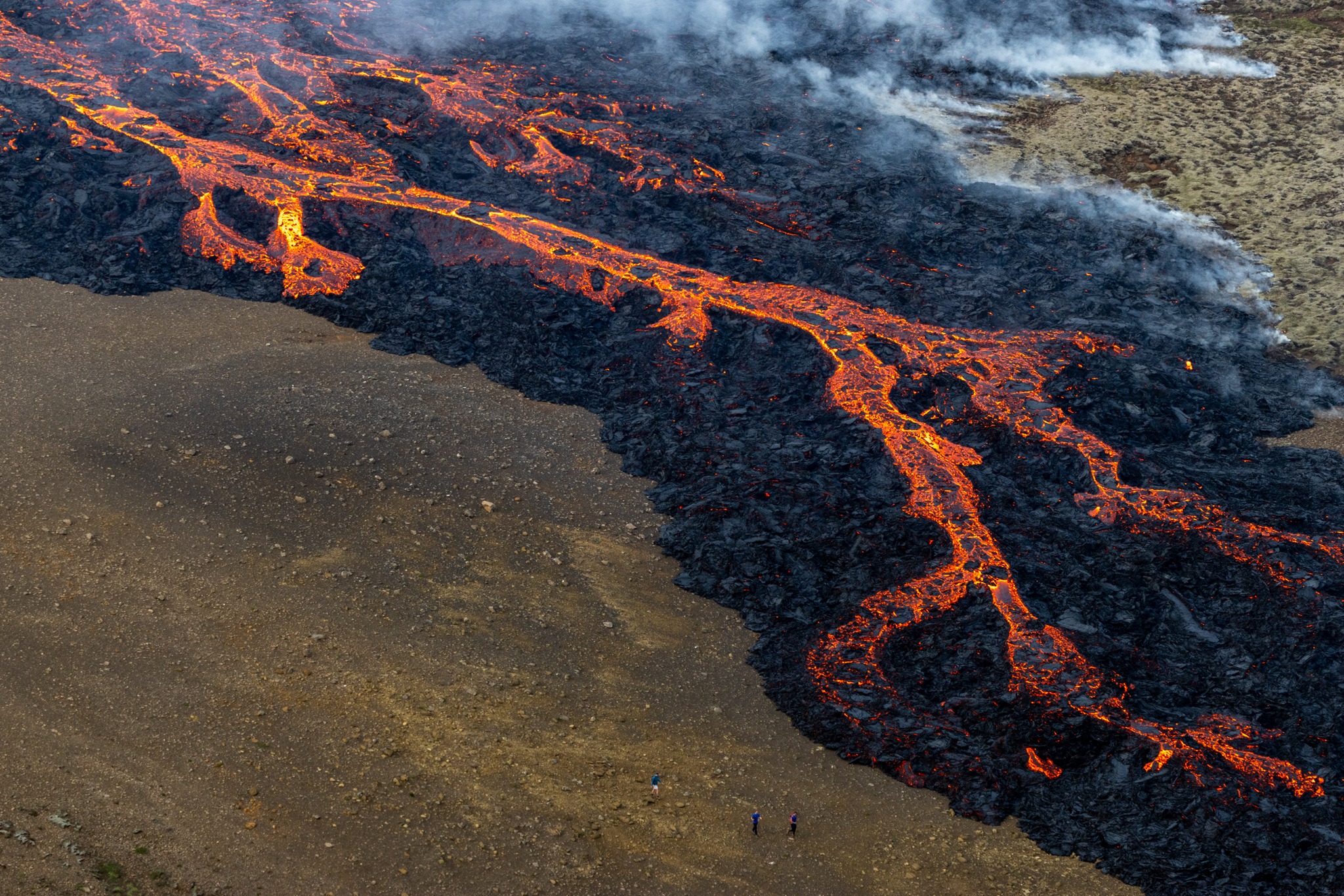
Tremor levels peaked between 21h00 on 10 July and 00h00 on 11 July, then steadily declined through 11h00. By 12h50 on 11 July the intensity of the eruption had noticeably decreased, with fewer active lava fountains. Only one vent with an elongated crater and multiple lava fountains was active by 16h35. Gas plumes rose as high as 4 km above the vent. Lava flows mostly traveled SE and flowed into a shallow valley S of Litli-Hrútur. IMO noted that if lava continued to flow S it may come into contact with the 2022 Merardalir lava flow. A 10-km-long trail from the road up to the eruption site was opened to the public.
Sources: Icelandic Meteorological Office (IMO), Almannavarnadeild ríkislögreglustjóra (National Commissioner of the Icelandic Police and Department of Civil Protection and Emergency Management), Institute of Earth Sciences , GVP
Photos : RUV , Almannavarnadeild ríkislögreglustjóra .
Italy , Stromboli :
WEEKLY BULLETIN, from July 03, 2023 to July 09, 2023 (issue date July 11, 2023)
ACTIVITY STATUS SUMMARY
In the light of the monitoring data, it is highlighted:
1) VOLCANOLOGICAL OBSERVATIONS: Explosive volcanic activity of the Strombolian type with a total frequency at an average level and with an explosion intensity at a low level in the two North and Center-South zones.
2) SEISMOLOGY: The seismological parameters monitored do not show any significant variations.
3) GROUND DEFORMATIONS: The ground deformation monitoring networks did not show any significant variations.
4) GEOCHEMISTRY: SO2 flux is at medium-low level
The CO2 flux in the Pizzo area displays medium to high values.
The C/S data in the plume shows a consistent trend settling on medium-high values.
The isotopic ratio of Helium dissolved in the heat sinks shows a slight increase, reaching medium to high values.
5) SATELLITE OBSERVATIONS: Thermal activity observed by satellite was generally low level with rare and isolated mid level anomalies.
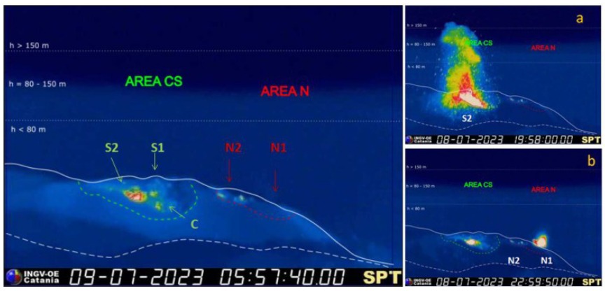
The crater terrace seen from the thermal camera located on the Pizzo sopra la Fossa with the delimitation of the Center-South and North crater zones (AREA CS and AREA N respectively). Symbols and arrows indicate the names and locations of active vents, the area above the crater terrace is divided into three height ranges relative to the intensity of the explosions. In (a) the activity produced by vent S2 in zone CS and in (b) at N1 in zone N (respectively on July 8).
VOLCANOLOGICAL OBSERVATIONS
During the period under observation, the eruptive activity of Stromboli was characterized by the analysis of the images recorded by the network of INGV-OE surveillance cameras on the visible and on the thermal (190 m altitude, Punta Corvi, 400 m above sea level and Pizzo) and by site inspections in the summit area on July 4, 6 and 8.
The explosive activity was produced by three eruptive vents located in the North crater area (N1 and N2) and one located in the Center-South crater area. Overall, the daily average frequency of total explosive activity produced by the two crater areas settled on a downward trending average level. The average partial frequency for each crater area does not show any specific eruptive prevalence between the two areas which place their activity at a low level. The explosions were mainly produced by N1 and N2 (N zone) and by S2 (CS zone) with a mainly fine component (ash) mixed with the coarse component for N1 and N2 and mainly coarse in S2. In the latter, the projection activity observed in the previous weeks continues. In both areas of the crater, the intensity of the explosions was at a low level. With regard to S1 and the central zone, their activity consisted of variable rate degassing without eruptive activity.

Inspections in the summit area between July 4 and July 8.
Inspections on July 4, 6 and 8 were carried out in the summit area in order to characterize the eruptive activity and to evaluate any changes in the morpho-structural structure of the crater terrace by direct soundings and by drones. Observations of eruptive activity on July 4 and 8 (between 11:30 a.m. and 1:30 p.m. local time), indicated an overall medium-low frequency (with a maximum of 12 events/h) with medium/high jet intensity in the South zone and medium in the North zone. From time to time, a slight rolling of blocks along the Sciara del Fuoco was observed. In detail, in the North area, the N1 vent showed emissions of ash or ash mixed with coarse material, while occasional detonations were heard from N2 in the absence of visible material. As for the Center area, it continues to show no visible activity as in the previous period. The S1 vent showed occasional puffs of gas from the little hornito, while the S2 vent was characterized by intense spatter activity from two vents inside, interspersed with jets of coarse material, with a maximum height about 200m.
The inversion of the data acquired by drones on July 6 made it possible to update only the morpho-structural structure of the Sciara del Fuoco and not of the crater terrace, this due to the dispersion of the volcanic plume towards the East with consequent coverage/lack of visibility of the crater area. Nevertheless, as observed on July 4, the crater terrace did not show substantial changes compared to previous inspections carried out between June 12 and 14. Similar stability from May 2023 readings was observed for the ravine formed during October 2022 eruptive activity. Thermal and visible readings also highlighted various thermal anomalies near the fumarole fields and crater rims. During the observation period of approximately 5.5 hours, explosions occurred on average every 9 minutes.
Source : INGV
Photos : INGV , Stromboli stati d’animo.
Alaska , Shishaldin :
AVO/USGS Volcanic Activity Notice
Current Volcano Alert Level: WATCH
Previous Volcano Alert Level: ADVISORY
Current Aviation Color Code: ORANGE
Previous Aviation Color Code: YELLOW
Issued: Wednesday, July 12, 2023, 12:13 PM AKDT
Source: Alaska Volcano Observatory
Notice Number: 2023/A1035
Location: N 54 deg 45 min W 163 deg 58 min
Elevation: 9373 ft (2857 m)
Area: Aleutians
Volcanic Activity Summary:
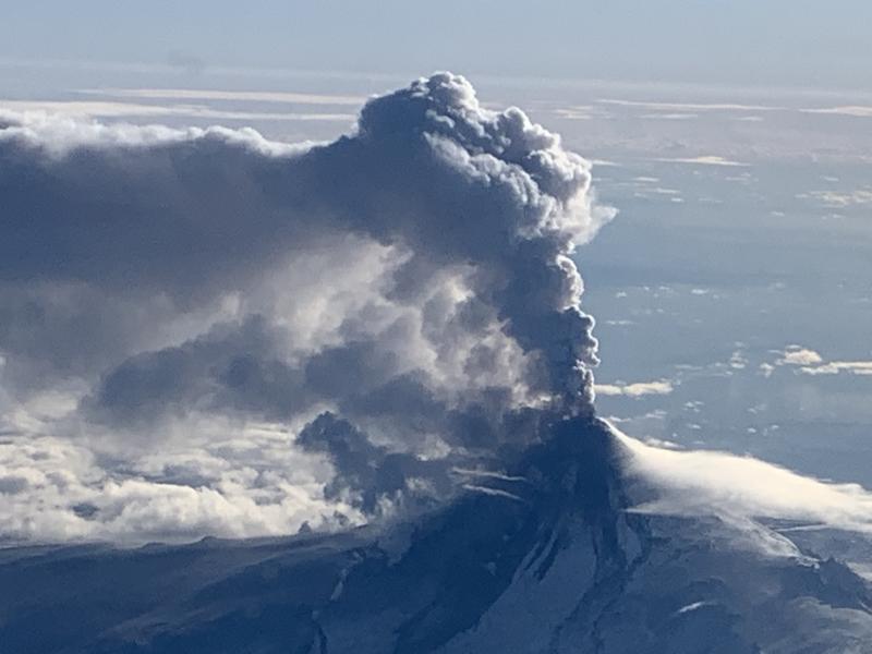
Strongly elevated surface temperatures continue to be observed at the summit of Shishaldin Volcano in satellite data. Incandescence at the summit was observed in web camera images from last night and sulfur dioxide was detected in satellite data over the past day. In addition, seismic tremor amplitudes have increased over the past day. Together, these observations suggest that lava is likely present within the summit crater of Shishaldin. In response, the Alaska Volcano Observatory is raising the Aviation Color Code to ORANGE and the Alert Level to WATCH.
Shishaldin is monitored by local seismic and infrasound sensors, web cameras, and a telemetered geodetic network. The local monitoring network is partially impaired, therefore AVO is also using nearby geophysical networks, satellite data and regional infrasound and lighting data to detect activity. AVO will continue to closely monitor unrest at Shishaldin Volcano.
Source : AVO
Photo : Woodsen Saunders , AVO ( archive).
Papua New Guinea , Bagana :
An explosive eruption at Bagana on 7 July send a large ash, gas, and steam plume to high altitudes and caused significant ashfall in local communities. A report issued by the Autonomous Bougainville Government (Torokina District, Education Section) on 10 July noted that significant ash began falling during 20h00-21h00 on 7 July and covered most areas in the Vuakovi, Gotana (9 km SW), Koromaketo, Laruma and Atsilima villages. By about 22h00 on 7 July the eruption plume had reached upper tropospheric altitudes based on satellite images. Sulfur dioxide detections in satellite images from 8 July indicated that the plume, likely a mixture of gases, ice, and ash, had risen to 16-18 km (52,500-59,100 ft) a.s.l., reaching the tropopause. Ashfall reportedly continued until 9 July. The ashfall covered vegetation, destroying bushes and gardens, and contaminated rivers and streams used for washing and drinking water; residents drank from coconuts and used fresh ground water accessible through bamboo pipes.
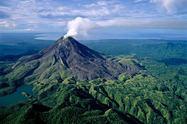
Bagana volcano, occupying a remote portion of central Bougainville Island, is one of Melanesia’s youngest and most active volcanoes. This massive symmetrical cone was largely constructed by an accumulation of viscous andesitic lava flows. The entire edifice could have been constructed in about 300 years at its present rate of lava production. Eruptive activity is frequent and characterized by non-explosive effusion of viscous lava that maintains a small lava dome in the summit crater, although explosive activity occasionally producing pyroclastic flows also occurs. Lava flows form dramatic, freshly preserved tongue-shaped lobes up to 50 m thick with prominent levees that descend the flanks on all sides.
Sources: Andrew Tupper, Natural Hazards Consulting, Simon Carn, Rabaul Volcano Observatory (RVO), Autonomous Bougainville Government, GVP.
Photo : GVP.
Japan , Kuchinoerabujima :
JMA reported that shallow volcanic earthquakes at Kuchinoerabujima had been occurring frequently starting in late June with most epicenters located near Furudake Crater, and some near Shindake Crater (just N of Furudake). Both the number and magnitude of the volcanic earthquakes increased on 9 June and remained elevated through 12 July; there were 151 events on 9 July, 319 on 10 July, 276 on 11 July, and 172 by 15h00 on 12 July. The public was previously warned that ejected blocks and pyroclastic flows may affect areas within 2 km of Shindake, and at 16h00 on 10 June the public was also warned to stay 2 km away from Furudake. The Alert Level remained at 3 (on a scale of 1-5).
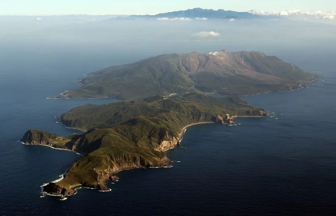
A group of young stratovolcanoes forms the eastern end of the irregularly shaped island of Kuchinoerabujima in the northern Ryukyu Islands, 15 km W of Yakushima. The Furudake, Shindake, and Noikeyama cones were erupted from south to north, respectively, forming a composite cone with multiple craters. All historical eruptions have occurred from Shindake, although a lava flow from the S flank of Furudake that reached the coast has a very fresh morphology. Frequent explosive eruptions have taken place from Shindake since 1840; the largest of these was in December 1933. Several villages on the 4 x 12 km island are located within a few kilometers of the active crater and have suffered damage from eruptions.
Source: Japan Meteorological Agency (JMA), GVP.
Photo : Asahi Shimbun