November 23 , 2021.
Peru , Sabancaya :
Analysis period: November 15, 2021 to November 21, 2021, Arequipa, November 22, 2021.
Alert level: ORANGE
The Geophysical Institute of Peru (IGP) reports that the eruptive activity of the Sabancaya volcano remains at moderate levels, that is to say with the recording of an average of 74 daily explosions, with columns of ash and gas up to an altitude of 2.0 km above the summit of the volcano and their consequent dispersion. Therefore, for the following days, no significant change is expected in eruptive activity.
The IGP recorded and analyzed the occurrence of 724 earthquakes of volcanic origin, associated with the circulation of magmatic fluids within the Sabancaya volcano. An average of 74 explosions was recorded daily. During this period, Volcano-Tectonic (VT) earthquakes associated with rock fracturing were located mainly in the Northwest and East of Sabancaya and presented magnitudes between M 1.9 and M 3.3.
The monitoring of the deformation of the volcanic structure using GNSS techniques (processed with fast orbits) does not present any significant anomalies. However, in general, an inflation process was observed in the northern sector (around the Hualca Hualca volcano). Visual surveillance made it possible to identify columns of gas and ash up to an altitude of 2.0 km above the summit of the volcano, which were scattered towards the South, South-West, West and North-East sectors of the volcano. Sabancaya. Satellite recordings have identified the presence of 8 thermal anomalies (maximum value of 30 MW) associated with the presence of a lava body on the surface of the volcano’s crater.
RECOMMENDATIONS
• Keep the volcanic alert level in orange.
• Do not approach within a radius of 12 km from the crater.
Source : IGP
Photo : Ingemmet
Spain / La Palma , Cumbre Vieja :
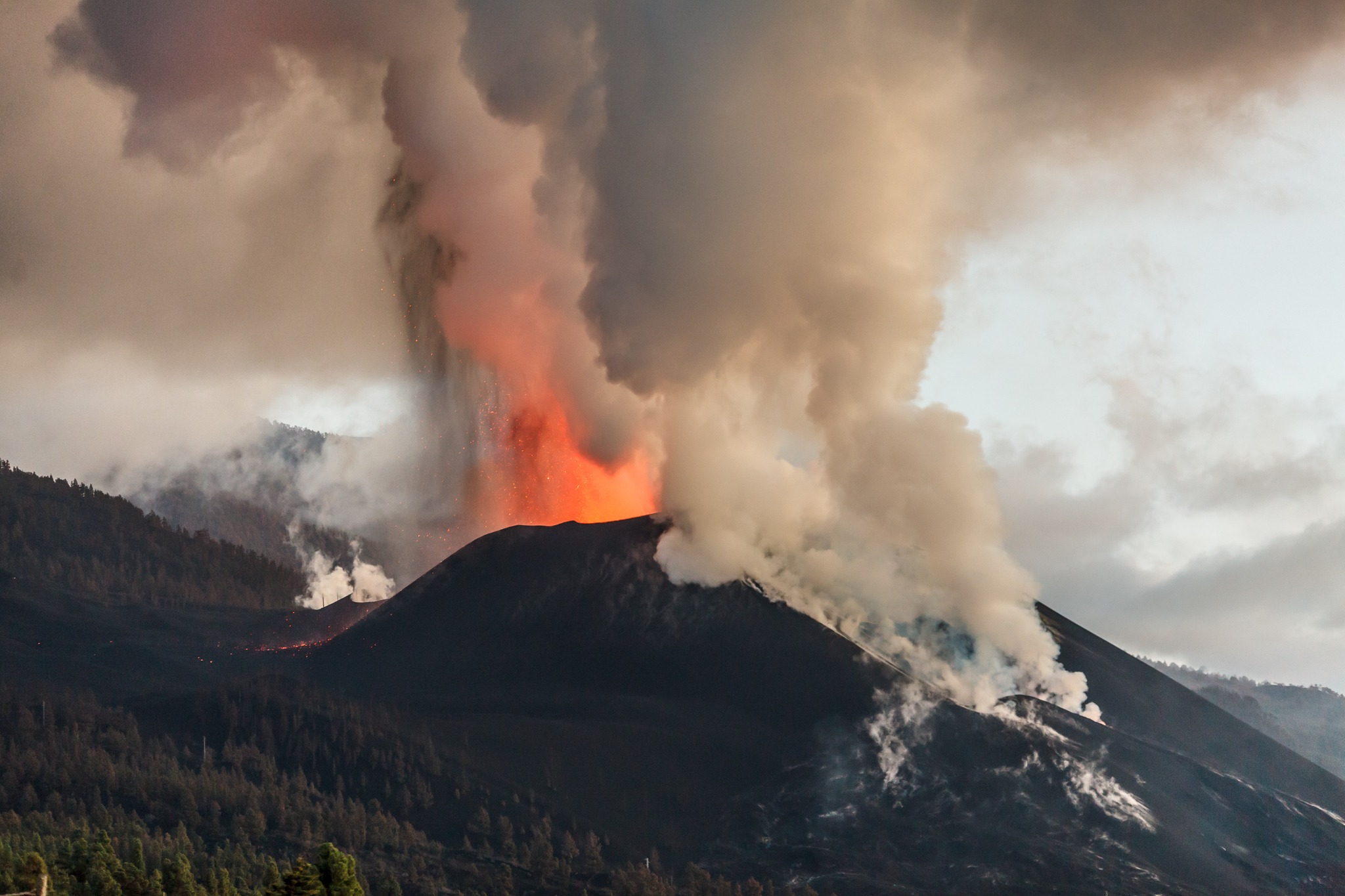
November 22 , 2021 09:00. UTC. Eruptive activity continues on La Palma.
Since the last declaration, 76 earthquakes have been located in the area affected by the volcanic reactivation of Cumbre Vieja, most of which have been located at depths greater than 30 km. Six of the earthquakes were felt by the population.
The largest earthquake was recorded at 08:09 UTC today with a magnitude of 4.8 mbLg and reached a maximum intensity of IV (EMS98) in the epicentral zone.
The tremor signal continues at low values, similar to the previous days.
The island’s network of permanent GNSS stations shows a complete reversal of the elevation recorded between November 17 and 19, a partial reversal of the deformation to the West and a gradual reversal of the deformation to the South at the station. LP03, which is closest to the eruptive centers.
In the rest of the stations, the slight deflation possibly linked to the deep seismicity has stabilized.
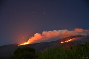
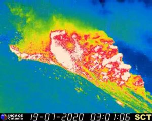
In view of the image calibrated at 08:45 UTC, a column height of 3000 m is estimated, and an ash cloud diffuses in the easterly direction.
The government of the Canary Islands has ordered the containment of the coastal districts of Tazacorte, San Borondón and El Cardón – because of the gases released by the entry into the sea of a new lava flow – near these population centers – and which are harmful to the health of the inhabitants. The measure affects around 3,000 people. The island’s airport continued to be inoperative on Monday, for the third day in a row, due to the accumulation of ash expelled by the Cumbre Vieja volcano, as reported by Aena. La Palma has recorded 76 earthquakes since last midnight, including one of magnitude 4.8, reported by the National Geographic Institute at 8:09 am and 36 kilometers deep.
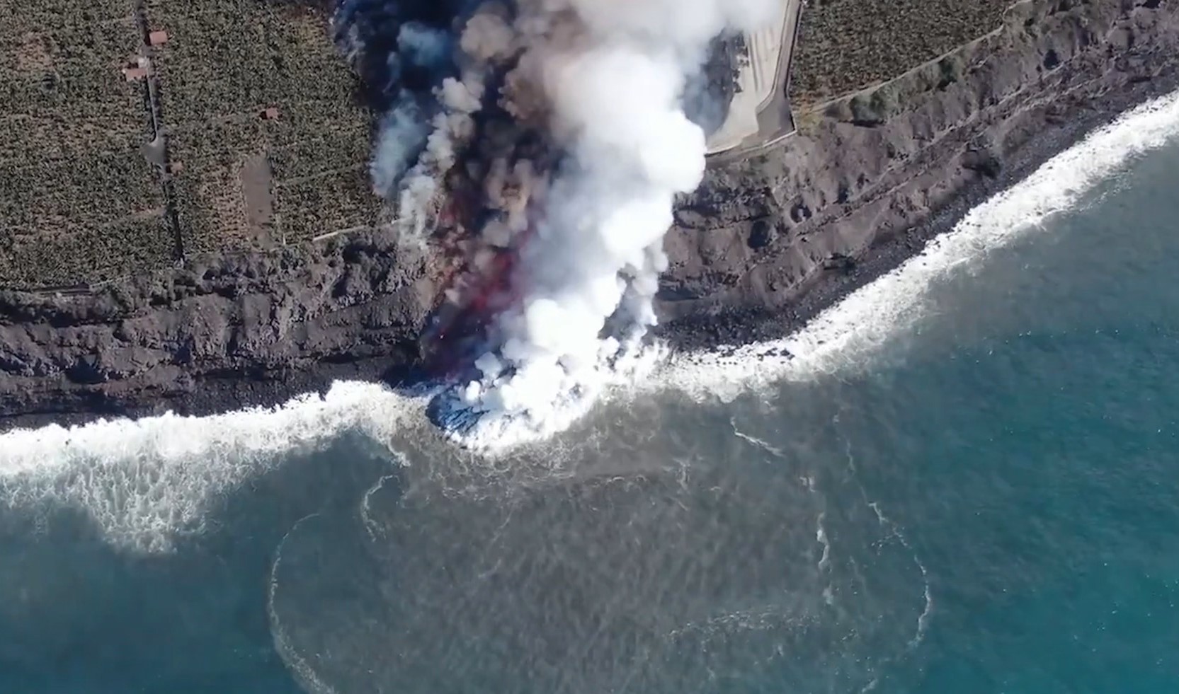
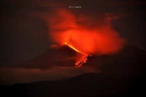
Lava from the volcano of La Palma came back into contact with the sea on Monday at 12 p.m. local time. This has led authorities to order the containment of around 3,000 people in the municipality of Tazacorte (west of the island) to prevent contact with the gas fumes. The new lava delta that is forming is located in the area known as El Perdido, about three kilometers south of the port of Tazacorte and just under two kilometers north of the delta that has started to form. September 28.
This tongue which reached the sea was in the last days the one which received the most contribution from the eruptive center, in particular through the flow 4. The flow above the previous flows prevented it from cooling down, which made possible its sustained progression, benefiting, moreover, from an increase in the flow of the eruptive center by the successive overflows which occurred from the cone.
Sources : IGN es , El Pais .
Photos : Noticias4Vision , TICOM SOLUTIONS .
Philippines , Taal :
TAAL VOLCANO BULLETIN 23 November 2021 8:00 AM
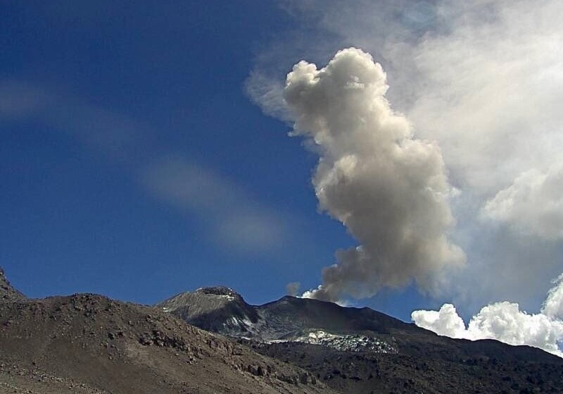
In the past 24-hour period, the Taal Volcano Network recorded thirty (30) volcanic earthquakes, including twenty-three (23) volcanic tremor events having durations of 2 to 5 minutes, four (4) low-frequency volcanic earthquakes, three (3) hybrid volcanic earthquakes and low-level background tremor that has persisted since July 7, 2021. Three (3) short-lived phreatomagmatic bursts were recorded at 8:11 AM, 8:17 PM and 8:34 PM yesterday, that lasted 1 to 5 minutes based on the seismic record.
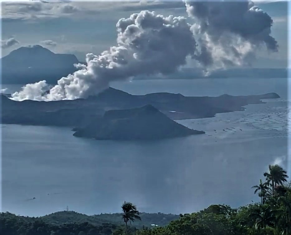
These events produced plumes 200 to 1,500 meters tall that drifted southwest. Activity at the Main Crater was dominated by upwelling of hot volcanic fluids in its lake which generated plumes 2,100 meters tall that drifted southwest. Sulfur dioxide (SO2) emission averaged 6,643 tonnes/day on 22 November 2021. Based on ground deformation parameters from electronic tilt, continuous GPS and InSAR monitoring, Taal Volcano Island has been inflating since August 2021 while the Taal region continues to undergo very slow extension since 2020.
Alert Level 2 (Increased Unrest) prevails over Taal Volcano.
Source : Phivolcs .
Photo : Kyle Aranza
New Zealand , White Island :
Whakaari/White Island: Volcanic unrest continues with steam and mud discharge, decreased gas emissions, steady vent temperatures and lake level fall . Published: Tue Nov 23 2021 1:00 PM
Volcanic Alert Level remains at 2
Aviation Colour Code remains at Yellow
Recent gas and observation flights at Whakaari/White Island show a decrease in gas emissions and lake level. The vent temperatures remain steady around 240-260 °C. The volcano continues to emit traces of volcanic ash, and the effects on the ground of a small, but energetic discharge of steam and mud were observed. A state of moderate to heightened unrest continues. The Volcanic Alert Level remains at Level 2
Last week GNS scientists undertook a visual observation flight and a gas emission measurement flight. Temperature measurements of the active vent area were also made.

The gas measurements showed that emissions of volcanic gases have decreased since the last measurements on 2 November 2021. Sulphur Dioxide (SO2) has decreased to 484 tonnes per day from 681 tonnes per day. The emissions of Carbon Dioxide (CO2) decreased from 2712 to 1416 tonnes per day, while the Hydrogen Sulphide (H2S) also showed a decrease, from 38 to 19 tonnes per day. These data are consistent with gas continuing to be released from the molten material (magma) at depth beneath the volcano.
Temperatures measured in the active vent area have ranged from 202 °C to 264 °C during September-November 2021. Temperatures between 243 to 264 °C were recorded last week. In July and August 2021, the temperatures were in excess of 500-600 °C.
The level of water in the crater lake has retreated from the higher level observed earlier this month. The crater formed during the 2019 eruption is now partially filled by sediments deposited over the past couple of years.
Very weak ash emission was occurring during the observations last week; recent deposits of ash on the island are minor and only visible close to the active vents. Further intermittent ash emission may occur over the next weeks. The effects on the ground of what is thought to have been an energetic steam driven discharge of mud were observed around a new vent south of the main, high temperature active vent on the island. This new vent is near the base of the 2019 landslide area, which is also showing some movement again. This landslide has shown intermittent movement since the 2019 eruption.
Continuing cloudy and humid weather conditions during spring are allowing steam and gas plumes to form above the island on some days, but on others, the weather is often obscuring views of the island from the coast. During humid northerly conditions when volcanic gas emissions are high, volcanic fog (VOG) may reach the coast.
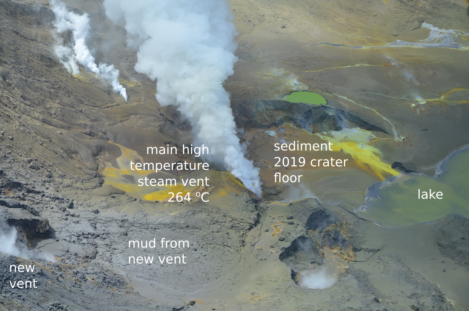
View of the active vent area at Whakaari/White Island on 18 November 2021.
The current level of activity is consistent with moderate to heightened levels of unrest. As such the Volcanic Alert Level remains at 2 and the Aviation Colour Code remains at Yellow.
Equipment that provides real-time monitoring on the island remains degraded. We are continuing to work on restoration options.
The Volcanic Alert Level reflects the current level of volcanic unrest or activity and is not a forecast of future activity.
Source : Geonet / Steven Sherburn ,Duty Volcanologist.
Photos : Brad Scott , Geonet .
Hawaii , Kilauea :
19°25’16 » N 155°17’13 » W,
Summit Elevation 4091 ft (1247 m)
Current Volcano Alert Level: WATCH
Current Aviation Color Code: ORANGE
Activity Summary:
Kīlauea volcano is erupting from a single vent in the western wall of Halemaʻumaʻu crater. As of this morning, November 22, 2021, lava is erupting at the summit. All lava activity is confined within Halemaʻumaʻu crater in Hawai‘i Volcanoes National Park. Seismic activity and volcanic gas emission rates remain elevated.
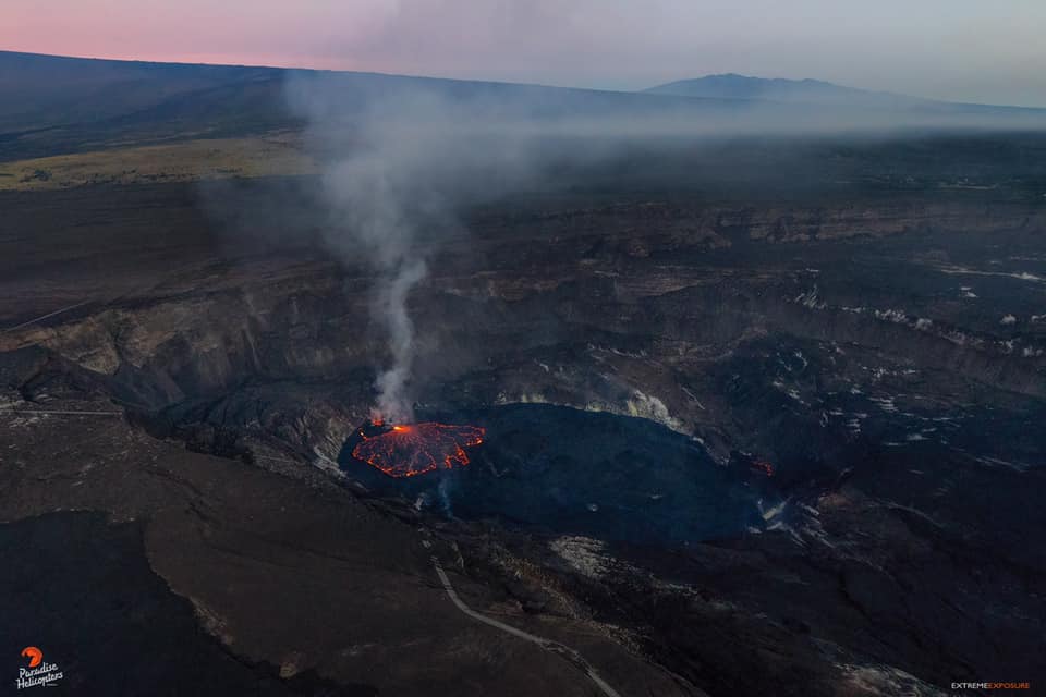
Summit Observations:
Sulfur dioxide (SO2) emission rates remain elevated, with an emission rate for November 18, 2021, of approximately 3800 tonnes per day. Summit tiltmeters overall recorded generally neutral tilt over the past day. Seismicity remains stable. Earthquake activity remains below background and volcanic tremor remains elevated since the beginning of the eruption.
Halemaʻumaʻu Lava Lake Observations:
Lava continues to erupt from a single vent in the western wall of Halemaʻumaʻu crater, while the eastern edge of the lake continues to advance onto the lowest of the exposed down-dropped caldera floor blocks. The western end of the lake showed a maximum elevation of approximately 805 meters (2640 ft) above sea level by HVO’s permanent laser rangefinder this morning, and a total increase of about 60 meters (197 ft) since lava emerged on September 29. Webcams show spatter and ponded lava within the west vent, an area of active lava at the surface of the lava lake, and sporadic oozes of lava along the cooler outer lake margins. The total erupted volume since the beginning of the eruption was estimated to be about 30 million cubic meters (7.8 billion gallons) on November 16.
Source : HVO
Photo : Bruce Omori.