February 23 , 2023.
Alaska , Trident :
AVO/USGS Volcanic Activity Notice
Current Volcano Alert Level: ADVISORY
Previous Volcano Alert Level: NORMAL
Current Aviation Color Code: YELLOW
Previous Aviation Color Code: GREEN
Issued: Wednesday, February 22, 2023, 9:47 AM AKST
Source: Alaska Volcano Observatory
Notice Number: 2023/A184
Location: N 58 deg 14 min W 155 deg 6 min
Elevation: 3599 ft (1097 m)
Area: Alaska Peninsula
Volcanic Activity Summary:
Earthquake activity beneath Trident Volcano has recently increased and is ongoing, although there have been no signs of unrest in other monitoring data. Due to this increase in seismic activity to above-background levels, the Alaska Volcano Observatory is raising the Aviation Color Code to YELLOW and the Volcano Alert Level to ADVISORY.
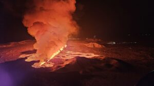
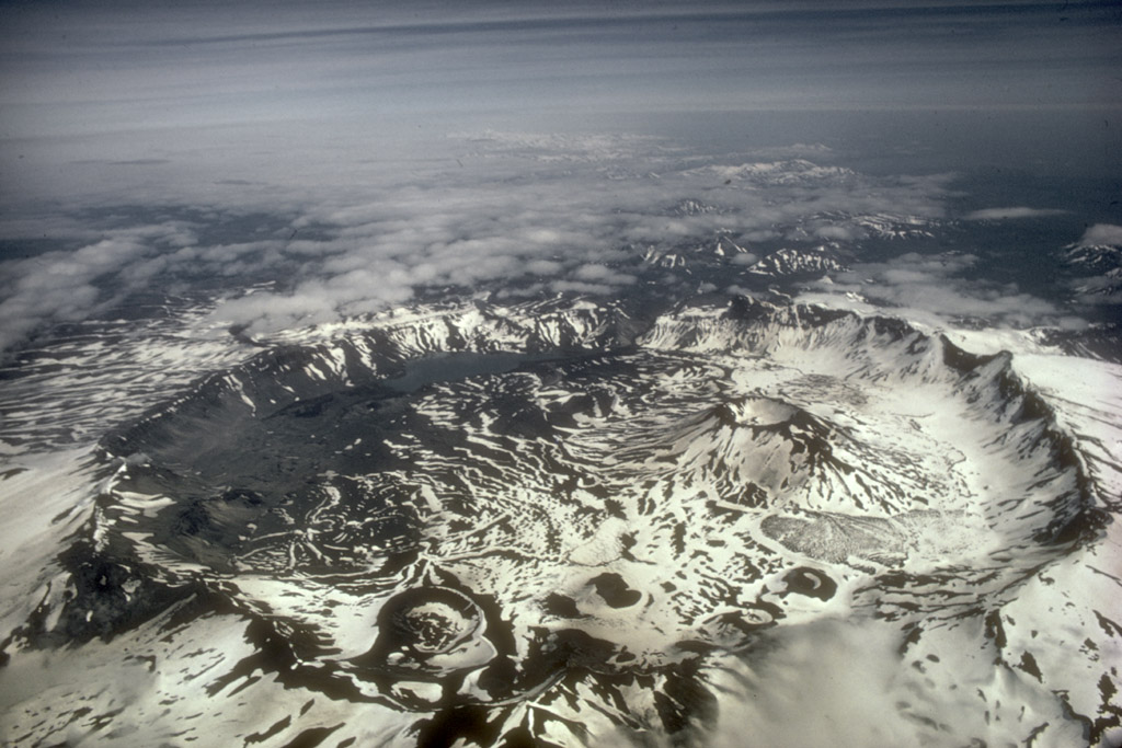
The multiple peaks of Trident Volcano as viewed from the top of Baked Mountain in the Valley of Ten Thousand Smokes, Alaska. Trident Volcano is composed of a cluster of andesite and dacite cones and is the only Katmai group volcano other than Katmai and Novarupta to have had historical activity. The Novarupta lava dome is visible at bottom, center.
The current period of seismic unrest, or earthquake swarm, began on August 24, 2022. Earthquake depths at the beginning of the swarm were mostly deep, around 25 km (16 miles) below sea level, and became progressively shallower to around 5 km (3 miles) over the following four days. Since late August 2022, most earthquakes have been located in the shallow crust, with depths less than 6 km below sea level. Since January 1, 2023, earthquakes under Trident are occurring at an average rate of about ten per day. The largest event since August was a M4.6 quake on November 20, but most earthquakes are much smaller. A few episodes of weak seismic tremor and low frequency earthquakes have also occurred.
Within the Katmai group of volcanoes, earthquakes are typically clustered in three regions: under Trident Volcano, under Mount Katmai to the east, and under Martin and Mageik volcanoes to the west. The current period of seismic unrest is most prominent in the area under Trident, but the rate of earthquakes has also increased in the region beneath Martin and Mageik volcanoes. Because of the initial sequence of deep earthquakes and continued episodes of tremor under Trident, it is most likely, though not certain, that the unrest observed in the area is due to movement of magma or magmatic fluids at depth there.
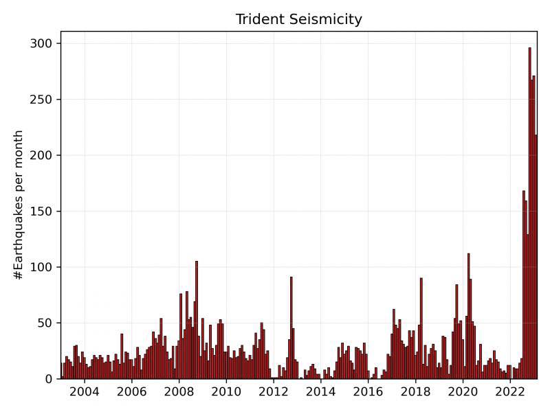
There is no indication that an eruption of Trident is imminent, or that one will occur. Increases in seismic activity have been detected previously at Trident and other similar volcanoes, with no subsequent eruptions. We expect additional shallow seismicity and other signs of unrest, such as gas emissions, elevated surface temperatures, and surface deformation to precede any future eruption, if one were to occur. Should activity increase, AVO will issue further notices.
AVO monitors Trident with a local network of seismometers, a webcam, remote sensing data, and regional infrasound and lightning networks.
Source : AVO
Photos : McGimsey, R. G / Alaska Volcano Observatory/U.S. Geological Survey , AVO.
Alaska , Aniakchak :
AVO/USGS Volcanic Activity Notice
Current Volcano Alert Level: ADVISORY
Previous Volcano Alert Level: NORMAL
Current Aviation Color Code: YELLOW
Previous Aviation Color Code: GREEN
Issued: Wednesday, February 22, 2023, 4:43 PM AKST
Source: Alaska Volcano Observatory
Notice Number: 2023/A192
Location: N 56 deg 54 min W 158 deg 12 min
Elevation: 4400 ft (1341 m)
Area: Alaska Peninsula
Volcanic Activity Summary:
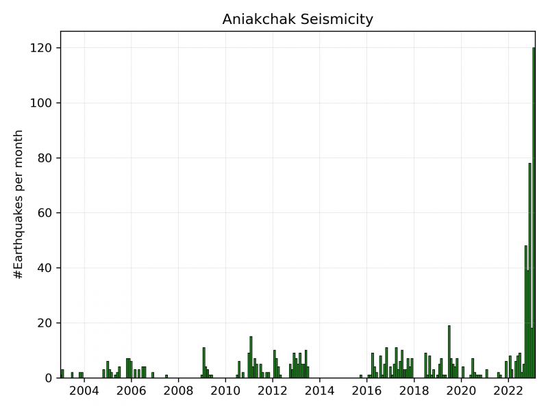
The number of earthquakes beneath Aniakchak volcano has recently increased and shifted to shallower depths. Due to this increase in seismic activity to above-background levels, the Alaska Volcano Observatory is raising the Aviation Color Code to YELLOW and the Volcano Alert Level to ADVISORY. There have been no signs of unrest in other monitoring data.
Background seismicity at Aniakchak has mostly been characterized by deep (>15 km or 9.3 miles), long-period events occurring at a rate of ~4 earthquakes per month. From October 2022 to present, the rate of earthquakes has been more elevated and characterized by shallower earthquakes at depths less than 9 km (5.6 miles) below sea level. The earthquake rate has further increased since January 31 with dozens of earthquakes detected per day, including a M3.7 earthquake on February 17.
There is no indication that an eruption of Aniakchak is imminent, or that one will occur. Increases in seismic activity have been detected previously at other similar volcanoes, with no subsequent eruptions. We expect additional shallow seismicity and other signs of unrest, such as gas emissions, elevated surface temperatures, and surface deformation to precede any future eruption, if one were to occur. Should activity increase, AVO will issue further notices.
AVO monitors Aniakchak with a local network, which consists of six seismometers, a web camera, and a single infrasound sensor, as well as satellite remote sensing data and regional infrasound and lightning networks.
Aniakchak volcano, located in the central portion of the Alaska Peninsula, consists of a stratovolcano edifice with a 10 km (6 mile) diameter summit caldera. The caldera-forming eruption occurred around 3,500 years ago. Postcaldera eruptions have produced lava domes, tuff cones, and larger spatter and scoria cone structures including Half-Cone and Vent Mountain all within the caldera. The most recent eruption occurred in 1931 and created a new vent and lava flows on the western caldera floor while spreading ash over much of southwestern Alaska. Aniakchak volcano is 25 km (15 miles) southeast of the nearest community, Port Heiden, and 670 km (416 miles) southwest of Anchorage, Alaska.
Source : AVO
Photos : M. Williams, National Park Service / Wikipedia , AVO.
Japan , Sakurajima :
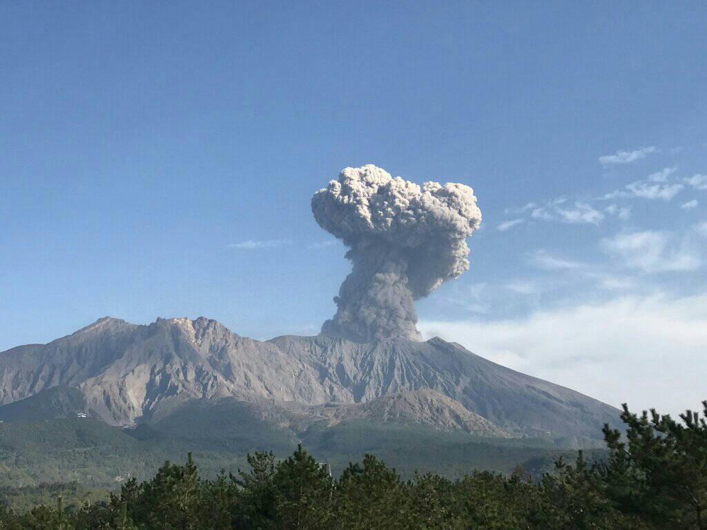
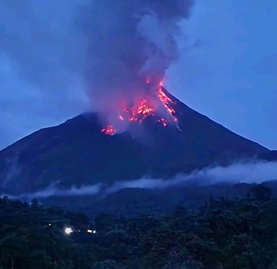
JMA reported ongoing eruptive activity at Minamidake Crater (at Aira Caldera’s Sakurajima volcano) during 13-20 February and crater incandescence was visible nightly. Five explosions and five eruptive events were recorded during the week. One of the explosions, at 1448 on 14 February, produced an ash plume that rose 2.4 km above the crater rim and ejected large blocks 1.1 km from the vent. Blocks 3 cm in diameter fell near the Arimura Lava Observatory in Arimura-cho, Kagoshima City, about 3 km SE. An explosion on 19 February produced an eruption plume that rose 1.2 km and ejected blocks that fell 1.1 km away. A very small eruptive event occurred at Showa Crater on 20 February. The Alert Level remained at 3 (on a 5-level scale), and residents were warned to stay 2 km away from the crater.
The Aira caldera in the northern half of Kagoshima Bay contains the post-caldera Sakurajima volcano, one of Japan’s most active. Eruption of the voluminous Ito pyroclastic flow accompanied formation of the 17 x 23 km caldera about 22,000 years ago. The smaller Wakamiko caldera was formed during the early Holocene in the NE corner of the Aira caldera, along with several post-caldera cones. The construction of Sakurajima began about 13,000 years ago on the southern rim of Aira caldera and built an island that was finally joined to the Osumi Peninsula during the major explosive and effusive eruption of 1914. Activity at the Kitadake summit cone ended about 4850 years ago, after which eruptions took place at Minamidake. Frequent historical eruptions, recorded since the 8th century, have deposited ash on Kagoshima, one of Kyushu’s largest cities, located across Kagoshima Bay only 8 km from the summit. The largest historical eruption took place during 1471-76.
Source : Agence météorologique japonaise (JMA), GVP.
Photo : Rizal M.
Indonesia , Karangetang :
The Center for Volcanology and Geological Hazard Mitigation (PVMBG) has issued a recommendation for an estimated risk zone covering a radius of 2.5 km between the summit of Kawah Dua (North) and the main crater (South). In addition, the danger zone also includes sectors from the peak to the West – North-West for 3 km and to the North-West – North for 4 km.
The volcanic activity also had an impact on the material damage, such as the access road to the village of Batubulan which was covered with volcanic materials up to a height of 5 m with an area of 300 m2. The Sitaro Islands Regency Regional Disaster Management Agency (BPBD) also reported that 2 village bridges were badly damaged.
Meanwhile, hot clouds and lava flows are still heading towards the Melebuhe River, but have the potential to shift towards the Batukore and Batuare Rivers, as well as Saboang. The bulk of volcanic material has the potential to become lahars in the rivers that disgorge at Kawah Dua and Kawah Utama.
Faced with volcanic activity still in progress, the PVMBG also recommends that residents prepare masks covering their nose and mouth to anticipate the potential danger of respiratory tract disorders in the event of ash rain.
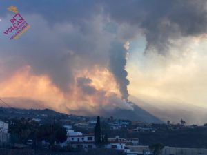
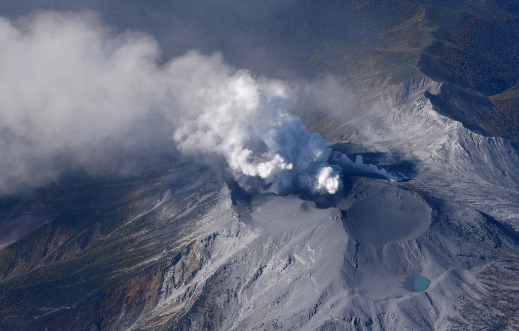
According to PVMBG the eruption at Karangetang’s Main Crater (S crater) continued during 14-21 February. Multiple nighttime webcam images posted with daily reports showed three main incandescent lava flows of different lengths descending the S, SW, and W flanks; a webcam image from 2156 on 17 February possibly showed incandescent material descending the SE flank. Incandescent rocks dotted the upper flanks, possibly from ejected or collapsed material from the crater; the incandescence was often most intense at the summit. Based on analyses of satellite imagery and weather models, the Darwin VAAC reported that during 16-20 February daily ash plume rose to an altitude of 2.1-3 km (7,000-10,000 ft) a.s.l. and drifted NNE, E, and SE. BNPB reported that as of 16 February there were as many as 77 people that had been displaced by the eruption and were in the East Siau Museum which was designated as a temporary evacuation shelter. The Alert Level remained at 3 (on a scale of 1-4) and the public were advised to stay 2.5 km away from Main Crater with an extension to 3.5 km on the S and SE flanks.
Source : BNPB , GVP.
Photo : Yola
Japan , Suwanosejima :
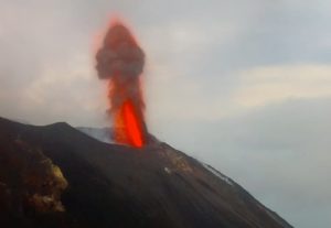
JMA reported that the eruption at Suwanosejima’s Ontake Crater continued during 13-20 February. Occasional ashfall and rumbling noises were reported in Toshima village (3.5 km SSW). The number of explosions per day increased on 13 February and then gradually decreased beginning on 16 February; a total of about 24 explosions occurred during the week. At 21h31 on 15 February an explosion produced an ash plume that rose 1.3 km above the crater rim and ejected large blocks as far as 900 m SE. An explosion around an hour later, at 22h37, ejected large blocks as far as 700 m SE. During 18-20 February explosions produced ash plumes that rose as high as 2 km above the crater rim and ejected large blocks as far as 400 m from the vent. Crater incandescence was visible at night. The Alert Level remained at 2 (on a 5-level scale) and residents were warned to stay 1 km away from the crater.
The 8-km-long island of Suwanosejima in the northern Ryukyu Islands consists of an andesitic stratovolcano with two historically active summit craters. The summit is truncated by a large breached crater extending to the sea on the east flank that was formed by edifice collapse. One of Japan’s most frequently active volcanoes, it was in a state of intermittent Strombolian activity from Otake, the NE summit crater, between 1949 and 1996, after which periods of inactivity lengthened. The largest recorded eruption took place in 1813-14, when thick scoria deposits blanketed residential areas, and the SW crater produced two lava flows that reached the western coast. At the end of the eruption the summit of Otake collapsed, forming a large debris avalanche and creating the open Sakuchi caldera, which extends to the eastern coast. The island remained uninhabited for about 70 years after the 1813-1814 eruption. Lava flows reached the eastern coast of the island in 1884. Only about 50 people live on the island.
Source : GVP
Photo : Ontake / Masanori Genko