February 12 , 2023.
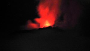
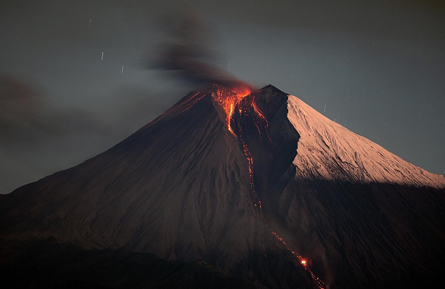
Hawaii , Kilauea :
Saturday, February 11, 2023, 8:40 AM HST (Saturday, February 11, 2023, 18:40 UTC)
19°25’16 » N 155°17’13 » W,
Summit Elevation 4091 ft (1247 m)
Current Volcano Alert Level: WATCH
Current Aviation Color Code: ORANGE
Activity Summary:
The summit eruption of Kīlauea Volcano, within Halemaʻumaʻu crater, continued over the past 24 hours. All recent eruptive activity has been confined to the crater. No significant changes have been observed at the summit or in either rift zone.
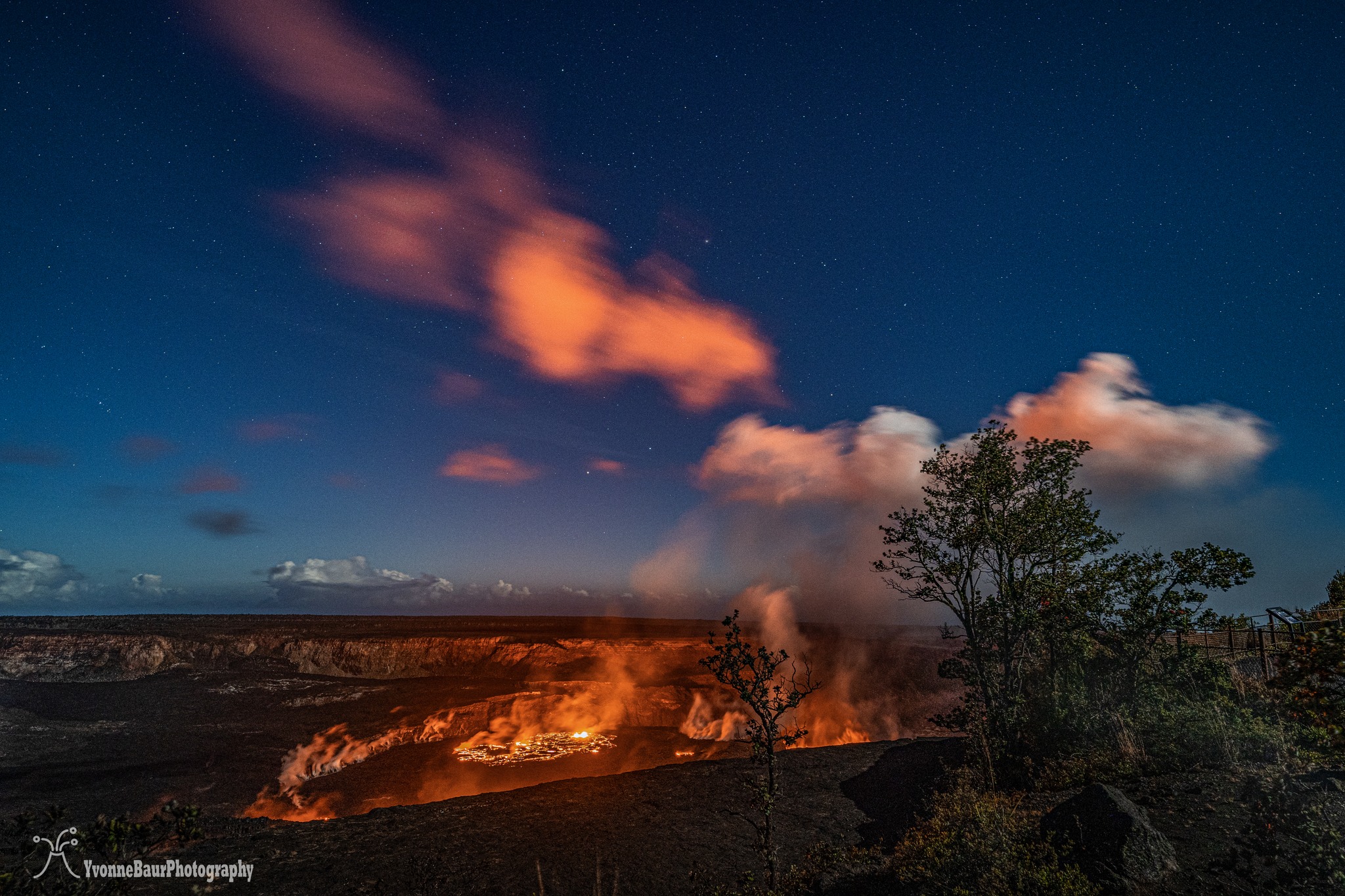
Halemaʻumaʻu crater Lava Lake Observations:
Eruption of lava in three locations of Halemaʻumaʻu crater floor continued over the past 24 hours. The eastern lake remains active and remains about 25 acres in size. The small southern lava fountain within the eastern lake is still active but diminished over the last day. The smaller western lake in the basin of the 2021–2022 lava lake remains active. The lava pond in the central portion of the crater floor is also active with nearly continuous expansive overflows in the last 24 hours. The southern small lava pond’s activity is diminished.
Summit Observations:
Summit tiltmeters remain mostly flat (no deflationary or inflationary trends) over the past 24 hours. Volcanic tremor remains above background levels. A sulfur dioxide (SO2) emission rate of approximately 2,800 tonnes per day (t/d) was measured on February 6, 2023.
Source : HVO.
Photo : Yvonne Baur
Guatemala , Santiaguito :
Weather conditions: Clear weather
Wind: North-East
Precipitation: 0.0 mm.
Activity:
According to web cameras and seismic stations, the activity of Santiaguito recorded and observed weak to moderate explosions expelling columns of ash and water vapor at a height of 3,300 meters above sea level spreading to the West of the Caliente dome. Weak to moderate avalanches are generated on the south-west and south flanks of the dome.
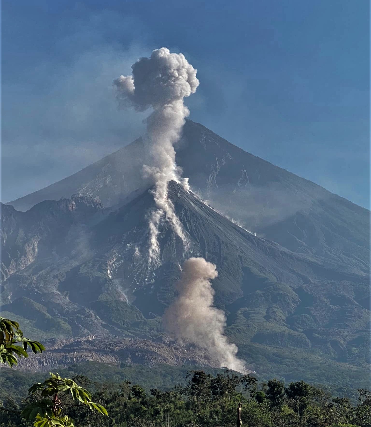
Lava flow activity on the southwest flank continues to generate avalanches on its flanks and front, lifting ash curtains in the area. Due to the unstable nature of the material in the lava flow, there is a likelihood of moderate to strong pyroclastic flows, so do not stay near or in riverbeds near the slopes of the volcano.
Source : Insivumeh
Photo : Armando Pineda.
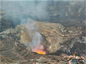
Chile , Lascar :
Volcanic Activity Report (RAV), Volcanological Observatory of the Southern Andes – Ovdas.
Seismic activity:
Over the past 24 hours, the seismic record continues to show volcano-tectonic activity (VT, associated with rock material rupture processes). On the other hand, earthquakes associated with fluid movements, both of the Tornillo type and pure LP, are recorded, although in fewer numbers.
Observations:
The VT earthquake with the highest energy had a local magnitude (ML) of 1.0, located 0.4 km south-southeast, with a depth of 1.9 km from the active crater .
A low intensity whitish degassing is observed.
![]()
Other Notes:
The GNSS stations show insignificant variations in recent days, the distance between the stations remains at average historical values, while the vertical displacements are practically zero and show no trend.
No new satellite thermal anomaly was detected (date of last image: February 11).
No new satellite SO2 anomaly was detected (date of last image: February 10).
The average SO2 flux on February 10 was 74.8 t/d, measured with DOAS equipment.
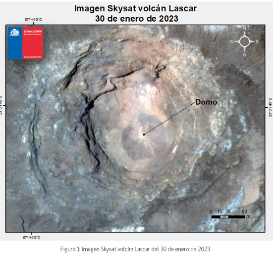
The potential impacts associated with the presence of a lava dome inside the active crater derive from its possible total or partial destruction, by an event with explosive characteristics. In this scenario, the appearance of pyroclastic flows and ballistic pyroclastic ejections in the current danger zone is expected. The assignment by ash fall outside the zoning radius is not excluded, which could occur, preferentially, in the West.
Source : Sernageomin.
Photos : Gabriel Orozco / Sernageomin
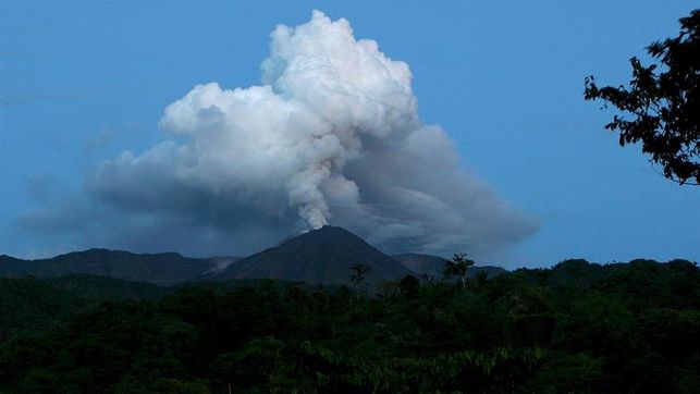
Ecuador , Sangay / Reventador :
DAILY REPORT OF THE STATE OF SANGAY VOLCANO, Saturday February 11, 2023.
Information Geophysical Institute – EPN.
Surface Activity Level: High, Surface Trend: Downward
Internal activity level: High, Internal trend: Downward.
Seismicity: From February 10, 2023, 11:00 a.m. to February 11, 2023, 11:00 a.m.:
For seismicity statistics, there are 16 hours of operation at the reference station.
Explosion (EXP) 41
Emission Tremors (TREMI ) 35
Long periods (LP): 26
Rains / Lahars:
Light rains are recorded in the sector, without causing lahars. *In the event of heavy rains, these could remobilize the accumulated materials, generating mudslides and debris that would descend the flanks of the volcano and flow into the adjacent rivers.**
Emission / Ash Column:
No surface-level emissions were observed due to persistent cloud cover in the area. The Washington VAAC published 2 reports of ash emissions, with a height of up to 1170 meters above crater level, in a northwesterly direction. There are no ashfall reports for today.
Gas:
The MOUNTS system detected 555.5 tons of sulfur dioxide (SO2), measured on 02/10/2023 at 1:43 p.m. TL
Other Monitoring Parameters:
The FIRMS system records 3 thermal anomalies. The MIROVA-MODIS system records 2 low thermal anomalies. The MIROVA-VIIRS system records 1 weak thermal anomaly and 1 moderate thermal anomaly during the last 24 hours.
Observation:
The area was completely cloudy for the past 24 hours.
Alert level: Orange.
——————————————————————————————————————————————–
DAILY REPORT OF THE STATE OF THE REVENTADOR VOLCANO, Saturday February 11, 2023.
Information Geophysical Institute – EPN.
Surface Activity Level: Moderate, Surface Trend: Downward
Internal activity level: Moderate, Internal trend: Downward.
Seismicity: From February 10, 2023, 11:00 a.m. to February 11, 2023, 11:00 a.m.:
For seismicity statistics, there are 17 hours of operation at the reference station.
Explosion (EXP): 18
Long periods (LP): 39
Emission Tremors (TREMI): 14
Rains / Lahars:
Rains were recorded in the area, but they did not cause lahars in the area.
Emission / Ash Column:
Steam and gas emissions were observed, with a height of up to 200 meters above summit level in a westerly direction. There have been no reports of ash emissions from Washington’s VAAC in the past 24 hours.
Gas:
The MOUNTS system did not detect sulfur dioxide (SO2) on 02/10/2023.
Other Monitoring Parameters:
During the last 24 hours, no thermal anomaly has been observed.
Observation:
During the night, incandescence was observed in the upper part, with the descent of blocks along the eastern flank to about 900 meters below the summit. This morning and until now the sector was cloudy.
Alert level: Orange.
Source : IGEPN.
Photos : Eqphos_fotografía , EDIIMA .
Mexico , Popocatepetl :
February 11, 11:00 a.m. (February 11, 5:00 p.m. GMT)
During the last 24 hours, according to the monitoring systems of the Popocatépetl volcano, 110 exhalations accompanied by water vapor, other volcanic gases and ash have been detected. 25 minutes of high frequency, low amplitude tremors were recorded.
During the morning and at the time of this report, an emission of water vapor, volcanic gases and ash was observed towards the North-East.
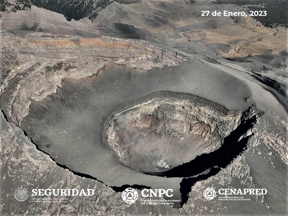
CENAPRED insistently reiterates the recommendation not to climb to the crater of the volcano because there is a possibility of explosions, as has been seen on several occasions in the past, involving the emission of incandescent fragments and in the event of heavy rains , to move away from the bottom of the ravines because of the danger of mudslides and debris.
The Popocatépetl volcanic alert traffic light is in YELLOW PHASE 2.
Source et photo : Cenapred.