February 07, 2023.
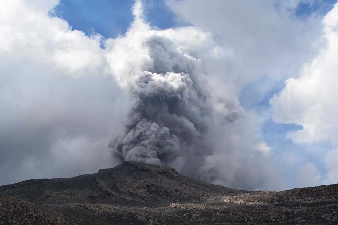
Chile , Lascar :
Volcanic Activity Report (RAV), Volcanological Observatory of the Southern Andes – Ovdas.
Seismic activity:
Over the past 24 hours, the seismic record from Lascar Volcano continues to be weak. During the previous days and when it was possible to analyze the recordings, the seismicity of the fluids presented in their signals characteristics with harmonic tendencies in their frequencies.
Observations:
The highest energy volcano-tectonic (VT) earthquake was located at a distance of 1.1 km in the South-South-East direction and at a depth of 2.9 km from the active crater.
At 20:53 UTC, a gaseous emission from the active crater of reddish color and low height (0.26 m) is observed, accompanied by a seismic signal of almost imperceptible amplitude.
Other Notes:
No deformation is recorded to highlight thanks to the GNSS instrumental network.
No new satellite thermal anomaly was detected (Source group MIROVA(3)).
The average SO2 flux was 71.59 t/d on February 4, measured with DOAS equipment.
No new SO2 satellite anomaly detected (date of last image: 04 February) (mounts-project.com).
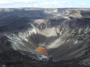
On the February 2 Skysat Collect satellite image, the dome is observed nestled inside the active crater, covering an area of 6,290 m2, which compared to the January 30 image shows a growth of 308 m2/day .
Source : Sernageomin.
Photo : Bas Wallet
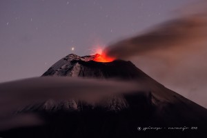
Peru , Sabancaya :
Analysis period: from January 30, 2023 to February 05, 2023, Arequipa, February 06, 2023.
Alert level: ORANGE
The Geophysical Institute of Peru (IGP) reports that the eruptive activity of the Sabancaya volcano remains at moderate levels, that is to say with the recording of an average of 43 daily explosions, with columns of ash and of gas up to 1.4 km altitude above the summit of the volcano and their subsequent dispersion. Therefore, for the following days, no significant change is expected in eruptive activity.
The IGP recorded and analyzed the occurrence of 403 earthquakes of volcanic origin, associated with the circulation of magmatic fluids inside the Sabancaya volcano. An average of 43 explosions was recorded daily, in addition to recording Volcano-Tectonic (VT) type events associated with rock fracturing inside the Sabancaya volcano.
Monitoring the deformation of the volcanic structure using GNSS techniques (processed with fast orbits) does not show any significant anomalies. However, in general, an inflation process was observed in the northern sector (surroundings of the Hualca Hualca volcano). Visual surveillance identified columns of gas and ash up to 1.4 km above the summit of the volcano, which were scattered towards the southwest and west sectors of Sabancaya. Satellite recordings identified the presence of 1 thermal anomaly, with a maximum value of 2 MW, associated with the presence of a lava body on the surface of the volcano’s crater.
RECOMMENDATIONS
• Keep the volcanic alert level orange.
• Do not approach within a radius of less than 12 km from the crater.
Source : Cenvul
Photo : Auteur inconnu.
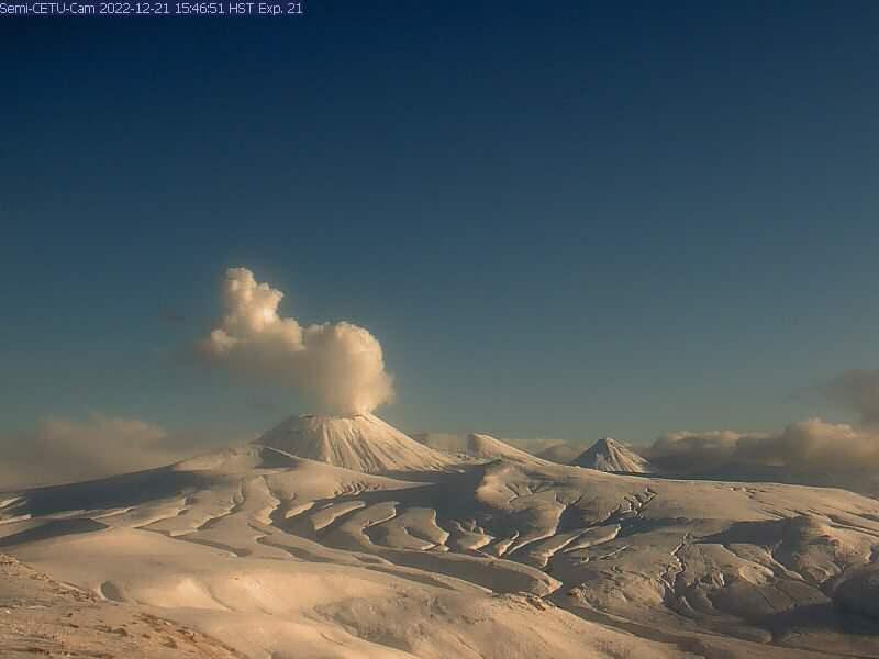
Alaska , Semisopochnoi :
51°55’44 » N 179°35’52 » E,
Summit Elevation 2625 ft (800 m)
Current Volcano Alert Level: WATCH
Current Aviation Color Code: ORANGE
Seismicity has been low over the past day with no unusual activity detected. No activity was observed in cloudy satellite views over the past day. Steam emissions observed in the occasional clear web camera view of the summit of the past day.
Small eruptions producing minor ash deposits within the vicinity of the active north crater of Mount Young and ash clouds usually under 10,000 ft (3 km) above sea level have characterized the recent activity. Additional ash-producing events could occur again with little warning.
Semisopochnoi volcano is monitored by local seismic and infrasound sensors, satellite data, web cameras, and regional infrasound and lightning networks.
Source et photo : AVO.
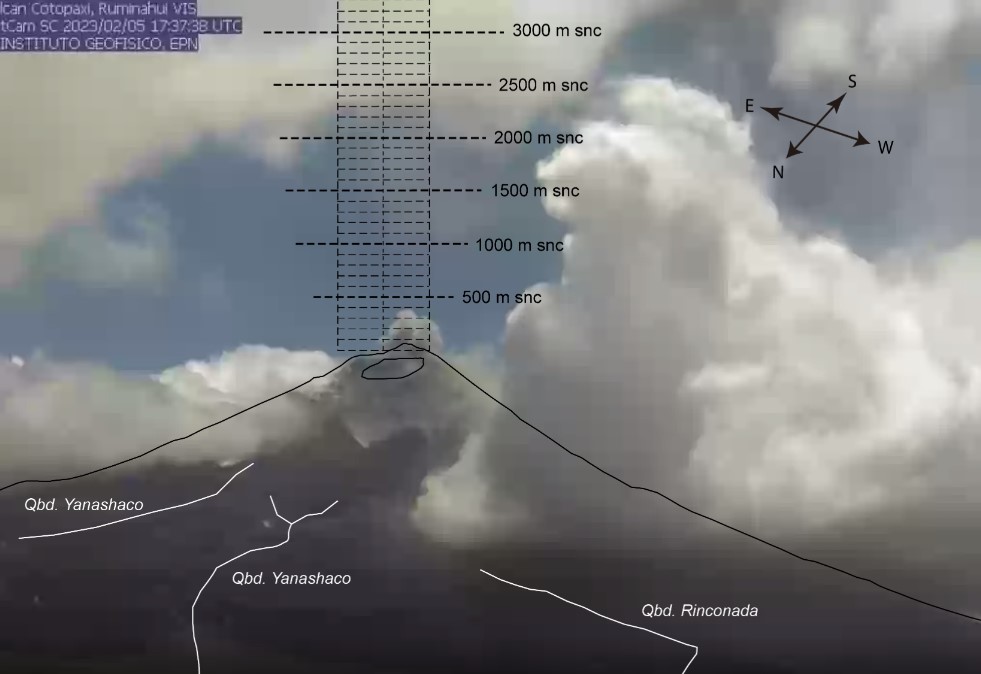
Ecuador , Cotopaxi :
DAILY REPORT OF THE STATE OF COTOPAXI VOLCANO, Monday February 06, 2023.
Information Geophysical Institute – EPN.
Surface activity level: Moderate, Surface trend: Ascending.
Internal activity level: Moderate, Internal trend: Ascending.
Seismicity: From February 05, 2023, 11:00 a.m. to February 06, 2023, 11:00 a.m.:
For seismicity statistics, there are 24 hours of transmission from the reference station.
Emission Tremor (TREMI) 25
Long Period (LP): 19
Rains / Lahars:
Yesterday afternoon, there were rains in the volcano area.
Emission / Ash Column:
An ash emission was observed yesterday afternoon, with a height of 200 meters above the level of the crater in a southerly direction. In the past 24 hours, Washington’s VAAC has not issued any ash emission statements.
Gas:
The MOUNTS system detected 380.3 tons of sulfur dioxide (SO2), measured on 02/05/2023 at 1:38 p.m. TL
Observation:
Most of the time the volcano remained cloudy.
Alert level: Yellow.
Source et photo : IGEPN
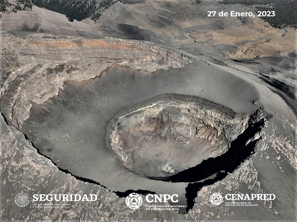
Mexico , Popocatepetl :
February 06, 11:00 (February 06, 17:00 GMT)
During the last 24 hours, according to the monitoring systems of the Popocatépetl volcano, 94 exhalations accompanied by water vapor, other volcanic gases and ash have been detected. Additionally, 11 minutes of high frequency tremor and a minor explosion were recorded yesterday at 8:41 p.m. local time.
During the morning and at the time of this report, an emission of water vapor, volcanic gases and ash was observed in a South-West (SW) direction.
CENAPRED insistently reiterates the recommendation not to climb to the crater of the volcano because there is a possibility of explosions, as has been seen on several occasions in the past, which involve the emission of incandescent fragments and in the event of strong rains, to move away from the bottom of the ravines because of the danger of mudslides and debris.
The Popocatépetl volcanic alert traffic light is in YELLOW PHASE 2.
Source : Cenapred