December 17 , 2022.
Italy , Stromboli / Etna :
Statement on Stromboli activity, December 16, 2022, 15:23 (14:23 UTC).
The National Institute of Geophysics and Volcanology, Osservatorio Etneo, announces that an overflow of lava from the North crater is observed through surveillance cameras. The phenomenon is still ongoing. With regard to the average amplitude of the volcanic tremor, no significant variation has been observed during the last 24 hours.
Stromboli’s sensor network has not recorded any significant changes over the past few hours.
Further updates will be communicated soon.
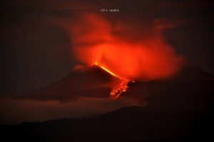
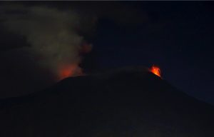
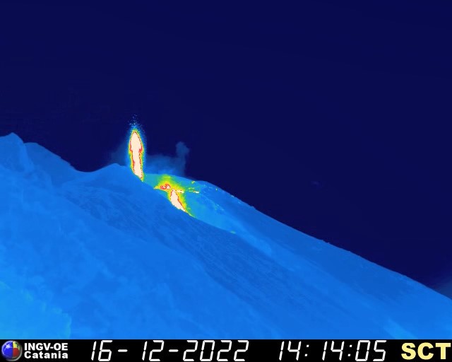
Etna activity:
It is an activity that we call « sub-terminal », therefore « almost summit », and very clearly it is closely linked to the Southeast Crater.
Etna has been erupting again for over a week. It could hardly be smaller, but we know very well that everything can change, and this mini crisis could become a large flow, perhaps accompanied by the spectacle of a beautiful Strombolian activity at the Southeast Crater.
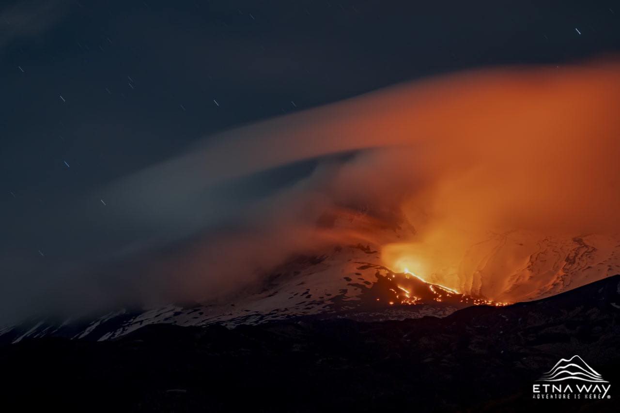
We’ve seen similar things in the past – this particular flow is reminiscent of the effusive activity that began around January 20, 2001 on the northeast flank of the Southeast crater, where the vent we called » Levantino ». Then the effusive activity continued for a few months in a very limited way, and then increased, but that’s another story.
Editor’s note: No press release from the INGV.
Sources: INGV , Boris Behncke ( comments).
Photos : INGV , Etnaway.
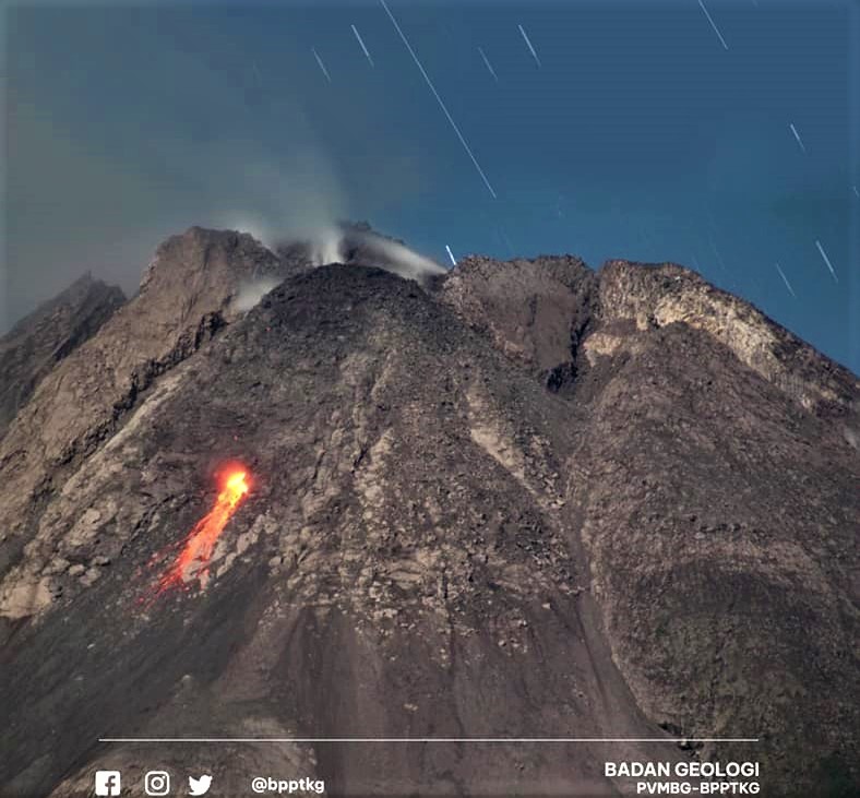
Indonesia , Merapi :
Report on the activity of Mount Merapi from December 09, 2022 to December 15, 2022, Published on December 16, 2022
RESULTS OF OBSERVATIONS
Visual
The weather around Mount Merapi is usually sunny in the morning and afternoon, while the evening is foggy. White smoke, thin to medium thickness, low pressure and 450 m high was observed from the Mount Merapi observation post in Badaban on December 09, 2022 at 07:30 WIB.
This week, there were 4 lava avalanches towards the South-West (Kali Bebeng and Kali Sat/Putih) with a slip distance of 1,500 m. The noise of the descent was heard 4 times from Babadan Post with low to medium intensity.
– There is no significant morphological change in the South-West dome and the central dome. The volume of the South-West dome is calculated fixed, i.e. 1,616,500 m3, while for the middle dome it is 2,772,000 m3.
Seismicity
This week, the seismicity of Mount Merapi showed:
39 deep volcanic earthquakes (VTB)
553 deep volcanic earthquakes (VTA),
255 avalanche earthquakes (RF),
14 emission earthquakes (DG),
7 tectonic earthquakes (TT).
183 multi-phase (MP) earthquakes
The intensity of this week’s seismicity is still quite high.
Deformation
The Mount Merapi deformation that was monitored using EDM and GPS this week showed a shortening rate of 0.6 cm/day.
Rain and lahars:
This week, there was rain at Kaliurang observation post with a rain intensity of 151 mm/h for 55 minutes on December 14, 2022. It is reported that there was an increase in flow in the Gendok rivers on December 15.
Conclusion
Based on the results of visual and instrumental observations, it is concluded that:
-The volcanic activity of Mount Merapi is still quite high in the form of effusive eruption activity. The state of the activity is defined at the « SIAGA » level.
-The current potential dangers are lava avalanches and hot clouds in the South-South-West sector including the Boyong River up to 5 km, the Bedog, Krasak, Bebeng Rivers up to 7 km. In the South-East sector, they cover the Woro River with a maximum of 3 km and the Gendol River for 5 km. While the ejection of volcanic materials during an explosive eruption can reach a radius of 3 km around the summit.
Source et photo : BPPTKG.
Hawaii , Mauna Loa :
Thursday, December 15, 2022, 8:04 AM HST (Thursday, December 15, 2022, 18:04 UTC)
19°28’30 » N 155°36’29 » W,
Summit Elevation 13681 ft (4170 m)
Current Volcano Alert Level: ADVISORY
Current Aviation Color Code: YELLOW
Activity Summary:
Mauna Loa is no longer erupting.
As of 7:00 a.m. today, December 15, webcams only captured residual incandescence and no lava movement in the F3 vent. The channels below the vent appear drained of lava and no longer feed the main flow front.
The inactive main flow front remains stalled about 1.7 mi (2.8 km) from the Daniel K. Inouye Highway (Saddle Road) when last measured on the morning of December 10. The inactive main flow front still glows at a few spots at night and may inch northward very slowly as it continues to settle.
Just days, ago, lava was full in the channels from the fissure 3 eruption on Mauna Loa’s Northeast Rift Zone. Over the past days, the eruption output has greatly reduced. The channels are drained of lava and no longer feed the main flow front.
Sulfur dioxide (SO2) emission rates are at background levels; on December 10, the emission rate was approximately 2,000 tonnes per day (t/d). The Hawaii Interagency Vog Information
Tremor (a signal associated with subsurface fluid movement) is no longer detectable; summit and Northeast Rift Zone inflation is slowing.
The significance of the continuing inflation while the flow field is inactive is not yet clear; it is common for eruptions to wax and wane or pause completely, but none of the eight recorded eruptions from Mauna Loa’s Northeast Rift Zone returned to high eruption rates after those rates decreased significantly. Nevertheless, the Hawaiian Volcano Observatory continues to closely monitor the current activity.
There is no active lava within Moku’āweoweo caldera nor in either rift zone. Satellite imagery shows the entire 2022 flow field cooling and no longer active.
Source : HVO.
Photo : USGS / K. Mulliken.
Alaska , Pavlof :
55°25’2″ N 161°53’37 » W,
Summit Elevation 8261 ft (2518 m)
Current Volcano Alert Level: WATCH
Current Aviation Color Code: ORANGE
Seismic activity at Pavlof has decreased over the past week, though intermittent seismic tremor was observed each day. The last explosion was detected on December 7. Conditions have been mostly cloudy over the past week, but occasional clear views showed no unusual activity. No elevated surface temperatures or incandescent lava have been observed in satellite and webcam images since December 2.
Periods of lava spatter and fountaining from the vent on the volcano’s upper east flank have been occurring since mid-November 2021.
Previous eruptions of Pavlof indicate that the level of unrest can change quickly and the progression to more significant eruptive activity can occur with little or no warning. Pavlof is monitored by local seismic and infrasound sensors, satellite data, web cameras, and regional infrasound and lightning networks.
Source : AVO
Photo : Ben David Jacob.
Guatemala , Fuego :
Activity :
5 to 8 weak and moderate explosions are recorded per hour which generate columns of ash from 4,500 to 4,800 meters above sea level (14,763 to 15,748 feet) dispersing over 10 to 15 km to the west. Some strong explosions generate abundant ash emissions. As a result of the explosive activity, low to moderate rumblings are also generated with weak shock waves that vibrate the roofs and windows of houses around the volcano.
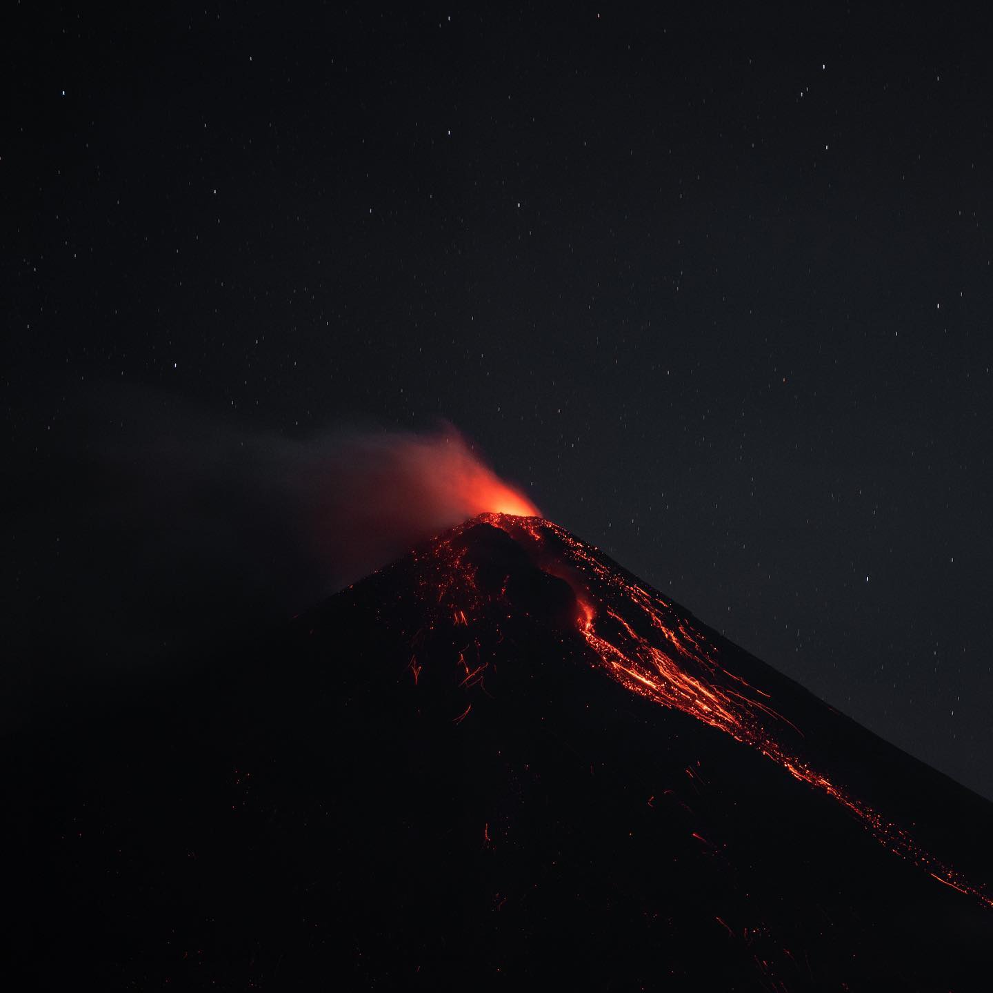
In addition, weak, moderate and strong avalanches, mainly in the direction of the Ceniza ravine and Las Lajas, extend to the edge of the vegetation. At night and early in the morning, pulses of incandescence are observed from 100 to 200 meters high. Due to the direction of the wind, fine ash falls are reported at Panimaché I and II, Morelia, El Porvenir, Santa Sofia, Finca Palo Verde, Yepocapa and others. Due to the direction of the wind at different heights, there is a probability of ash fall in communities northwest of the volcano, such as Santa Isabel, Quisaché and Acatenango.
Source : Insivumeh.
Photo : Diego Rizzo.