December 13 , 2022.
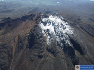
Hawaii , Mauna Loa :
Monday, December 12, 2022, 9:35 AM HST (Monday, December 12, 2022, 19:35 UTC)
19°28’30 » N 155°36’29 » W,
Summit Elevation 13681 ft (4170 m)
Current Volcano Alert Level: WATCH
Current Aviation Color Code: ORANGE
The Northeast Rift Zone eruption of Mauna Loa may still be active at the fissure 3 (F3) vent but all 2022 lava flows appear to be inactive.
As of 7:00 a.m. today, December 12, the Hawaiian Volcano Observatory overflight found only residual incandescence and no lava movement in the F3 vent; as they were leaving the field crew heard small explosions accompanied by sprays of spatter from the west end of the fissure 3 (F3) vent. The channels below the vent appear drained of lava and no longer feed the main flow front.
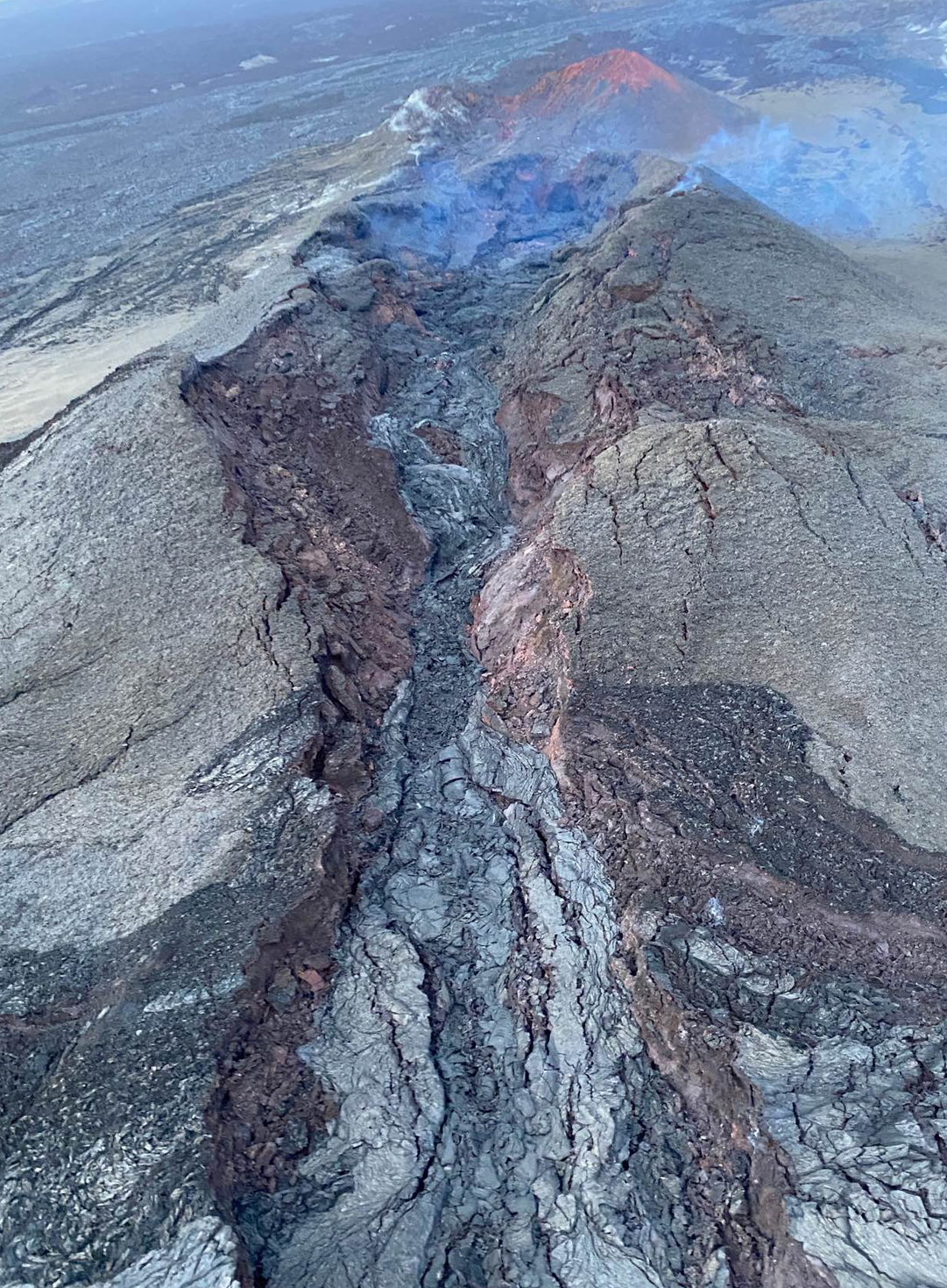
As of 7:00 a.m. on December 12, Hawaiian Volcano Observatory geologists observed only residual incandescence and no lava movement in the fissure 3 vent on the Northeast Rift Zone of Mauna Loa. The channels below the vent appear drained of lava and no longer feed the main flow front.
The inactive main flow front remains stalled about 1.7 mi (2.8 km) from the Daniel K. Inouye Highway (Saddle Road) when last measured the morning of December 10. The inactive main flow front still glows at a few spots at night and may inch northward very slowly as it continues to settle.
Sulfur dioxide (SO2) emission rates continue to be reduced; on December 10, the emission rate was approximately 2,000 tonnes per day (t/d).
Tremor ( signal associated with subsurface fluid movement) is no longer detectable; summit and Northeast Rift Zone inflation continues.
The significance of the continuing inflation while the flow field is inactive is not yet clear; it is common for eruptions to wax and wane or pause completely, but none of the eight recorded eruptions from Mauna Loa’s Northeast Rift Zone returned to high eruption rates after those rates decreased significantly. Nevertheless, the Hawaiian Volcano Observatory continues to closely monitor the current activity.
There is no active lava within Moku’āweoweo caldera nor in either rift zone. Satellite imagery shows the entire 2022 flow field cooling and no longer active.
Source : HVO.
Photo : USGS / F. Trusdell.
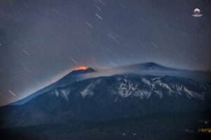
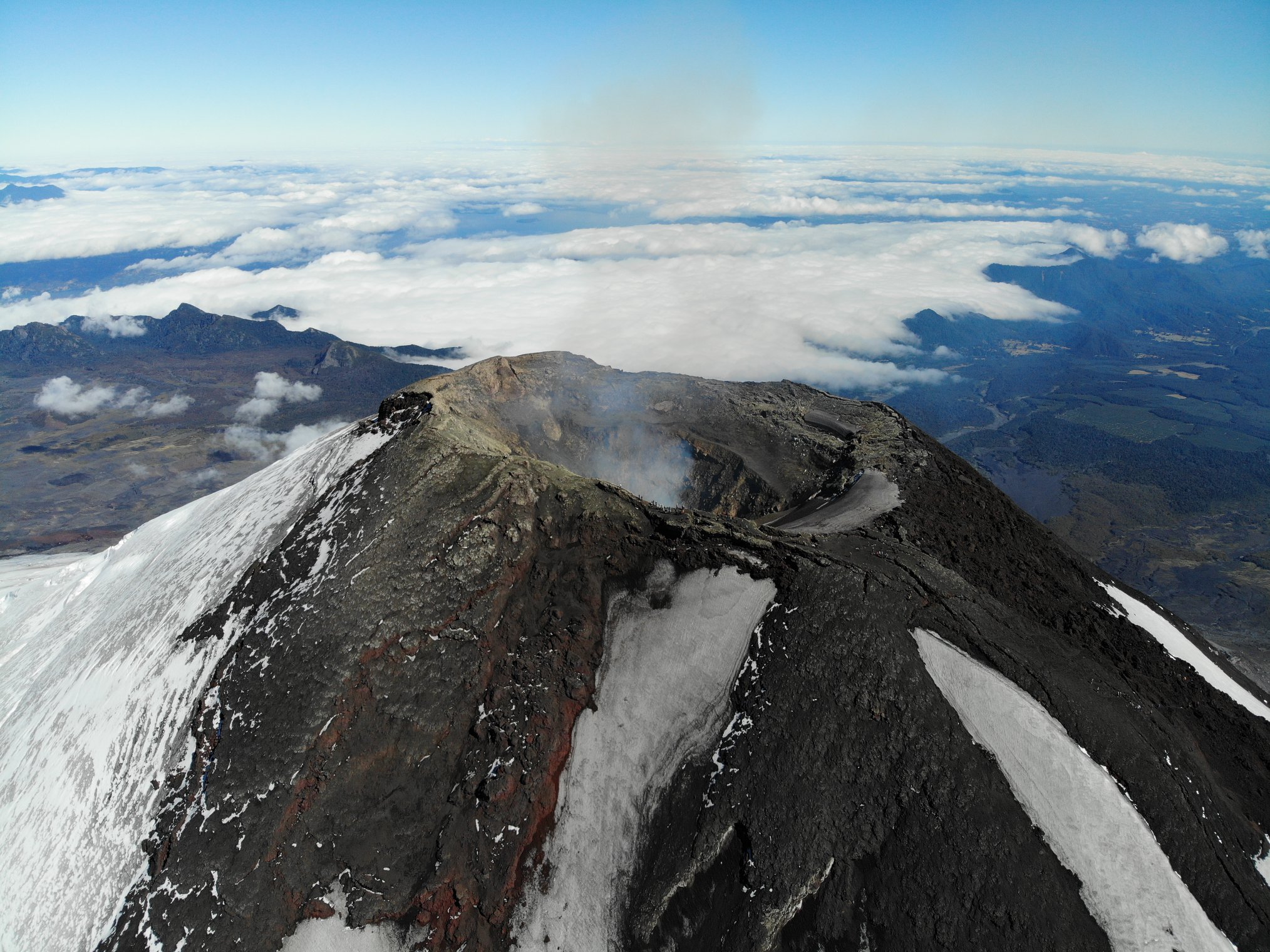
Chile , Villarica :
Seismology
The seismological activity of the period was characterized by the recording of:
A continuous tremor signal with energy values estimated from the RSAM between 0.8 and 1.0 µm/s, values considered low. This tremor signal had dominant frequencies between 1.0 and 1.2 Hz.
54 VT-type seismic events, associated with rock fracturing (Volcano-Tectonics). The most energetic earthquake presented a value of local magnitude (ML) equal to 1.9, located 5.0 km east-southeast of the volcanic edifice, with a depth of 5.1 km from the crater.
7911 LP-type seismic events, associated with fluid dynamics within the volcanic system (Long Period). The size of the largest earthquake assessed from the Reduced Displacement (DR) parameter was equal to 80 cm2.
576 discrete seismic events of the TR type, associated with the dynamics maintained over time of the fluids within the volcanic system (TRemor). The size of the largest earthquake assessed from the Reduced Displacement (DR) parameter was equal to 22 cm2.
Fluid Geochemistry
Data on sulfur dioxide (SO2) emissions obtained by optical differential absorption spectroscopy (DOAS) equipment, corresponding to the Los Nevados and Tralco stations, installed 10 km to the East-North-East (ENE) and 6 km east-southeast (ESE) of the active crater respectively, had an average value of 729 ± 104 t / d, with a maximum daily value of 1551 t / d on November 16. According to the activity of the volcano, these values are at levels considered normal.
Surveillance cameras
Intense continuous degassing of the active crater is identified, with a peak height of 820m occurring on 21 November. The degassing was accompanied by the emission of pyroclastic and ballistic projections dispersed by the wind at least on November 21, 23, 25, 26 and 27.
In the nocturnal recordings, a continuous glow of varying intensity is recorded, mainly from degassing and the emission of pyroclasts from the lava lake housed in the crater.
In addition, from November 20, a second focus of incandescence, of lower intensity, was identified on the southwestern edge of the crater, associated with degassing.
Satellite geomorphological analysis
From the observation of Planet Scope, Sentinel 2-L2A, Skysat Collect satellite images, photographs and thermal recordings made during an overflight, the lava lake housed in the crater is identified at a maximum temperature of 1,050°C, whose surface area decreased during the period evaluated. Lava lake activity generated an incipient cone of recent pyroclasts inside the crater and the accumulation of pyroclasts on the inner walls. In addition, pyroclastic deposits of basaltic composition (51.4% SiO2) are identified on the south, south-west, east and south-east flanks of the volcano, bomb-sized (> 40 cm) reaching up to 400 m from the center of the crater. In addition, concentric cracks were observed on the crater rim as well as oblique cracks in the southwestern sector of the volcano, which had already been identified in previous years.
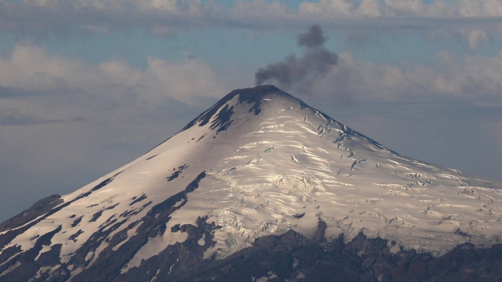
The Villarrica volcano remains with a dynamic where the seismic energy (evaluated from the RSAM parameter – average variations in seismic amplitude) presents a slow but constant increase, reaching average values of 1.1 μm / sec. Most of the seismic activity recorded is related to the surface dynamics of the lava lake, intermittently generating Strombolian-type explosions, which cause acoustic waves, the recording of thermal anomalies, incandescence and emission of high temperature pyroclasts in areas near the crater.
Due to the above, the possible assignment area is maintained at 500 meters and the technical alert is maintained in: YELLOW TECHNICAL ALERT: Changes in the behavior of volcanic activity.
Source : Sernageomin.
Photos : Take a Way , 24 horas .
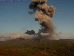
Guatemala , Fuego :
Activity :
The Fuego Volcano Observatory -OVFGO- reports a weak white fumarole at an altitude of 4,600 meters above sea level (15,091 feet), which is spreading in a West-South-West direction. There were 3 to 7 weak, moderate and a few strong explosions per hour, these generate columns of ash at an altitude of 4,700 to 4,800 meters above sea level (15,419 – 15,748 feet ) which disperse over about 20 km in a West and South-West direction due to the wind direction. During the night and early in the morning, incandescent pulses are observed at a height between 100 and 200 meters above the level of the crater.
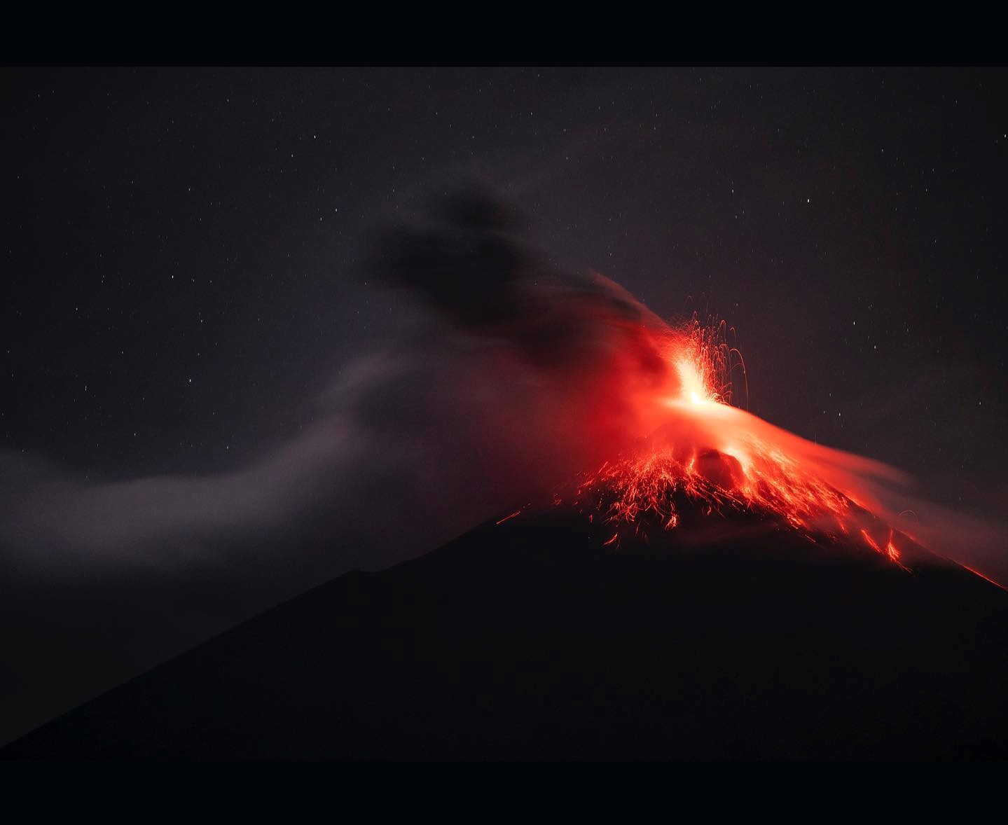
The explosions produce the descent of weak to moderate avalanches from the edge of the crater towards the ravines of Ceniza, Seca, Santa Teresa, Las Lajas, Taniluya and Trinidad. Low and moderate rumblings were generated, which cause shock waves that vibrate the houses near the volcano. Following the explosions, ashfall was recorded in the Panimaché I and II communities, Finca Palo Verde and others located west and southwest of the Fuego volcano. Low sounds similar to a train locomotive are reported with a duration of 1 to 4 minutes. Due to the wind speed, the lifting of ash curtains on the slopes of the volcano is noted. The lava flow towards the Barranca Ceniza is still active. The recommendations of the BEFGO bulletin n°123-2022 remain in force because the high temperature material deposited by the descent of the pyroclastic flows of the recent eruption persists.
Source : Insivumeh.
Photo : Diego Rizzo .
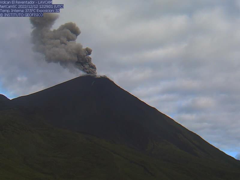
Ecuador , Reventador :
MONDAY DECEMBER 12, 2022
Since 7:50 p.m. TL, through satellite images (GOES-16), an ash cloud has been observed reaching 1500 meters above the crater and moving towards the southwest. Consequently, there is a probability of ash fall in the area located southwest of the volcano, in the province of Napo. It is recommended to take appropriate measures and receive information from official sources.
DAILY REPORT OF THE STATE OF THE REVENTADOR VOLCANO, Monday December 12, 2022.
Information Geophysical Institute – EPN.
Surface Activity Level: Moderate, Surface Trend: No change
Internal activity level: Moderate, Internal trend: No change.
Seismicity: From December 11, 2022, 11:00 a.m. to December 12, 2022, 11:00 a.m.:
There was no interruption in the transmission of data from the reference station for seismic statistics.
Explosion (EXP): 95
Long Periods (LP): 59
Emission Tremors (TREMI ): 7.
Harmonic Tremors (TRARM): 2
Rains / Lahars:
No rain was recorded in the area.
Emission / Ash Column:
During the last 24 hours several ash emissions have been observed to the west and the heights were around 1000 meters above the level of the crater. The Washington VAAC reported 4 alerts for emissions observed in the satellites, their direction remained West and the heights oscillated between 1,000 and 1,400 meters above the level of the crater.
Other Monitoring Parameters:
No thermal anomalies were recorded in the satellite systems.
Observation:
During the past 24 hours, the volcano has cleared occasionally, observing the emissions already described. At night, an incandescence was observed in the crater as well as the rolling of blocks along the western flank of the volcano up to 600 meters below the level of the crater. The lava flow descending on the northeast flank is still active.
Alert level: Orange.
Source and photo : IGEPN.
Peru , Sabancaya :
Analysis period: from December 05, 2022 to December 11, 2022, Arequipa, December 12, 2022.
Alert level: ORANGE
The Geophysical Institute of Peru (IGP) reports that the eruptive activity of the Sabancaya volcano remains at moderate levels, that is to say with the recording of an average of 40 daily explosions, with columns of ash and gas up to 2.0 km altitude above the summit of the volcano and their consequent dispersion. Therefore, for the following days, no significant change is expected in eruptive activity.
The IGP recorded and analyzed the occurrence of 289 earthquakes of volcanic origin, associated with the circulation of magmatic fluids inside the Sabancaya volcano. An average of 40 explosions was recorded daily, in addition to recording Volcano-Tectonic (VT) type events associated with rock fracturing inside the Sabancaya volcano.

Monitoring the deformation of the volcanic structure using GNSS techniques (processed with fast orbits) does not show any significant anomalies. However, in general, an inflation process was observed in the northern sector (surroundings of the Hualca Hualca volcano). Visual surveillance identified columns of gas and ash up to 2.0 km above the summit of the volcano, which were scattered towards the southern, northeast and southwest sectors of Sabancaya . Satellite recordings have identified the presence of 2 thermal anomalies, with a maximum value of 19 MW, associated with the presence of a lava body on the surface of the volcano’s crater.
RECOMMENDATIONS
• Keep the volcanic alert level orange.
• Do not approach within a radius of less than 12 km from the crater.
Source et photo : Cenvul