December 04 , 2022.
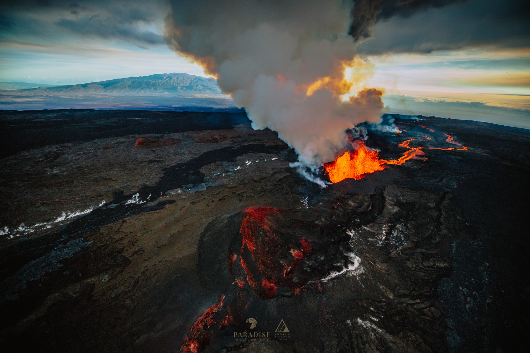
Hawaii , Mauna Loa :
Saturday, December 3, 2022, 16:32 HST (Sunday, December 4, 2022, 02:32 UTC)
19°28’30 » N 155°36’29 » W,
Summit Elevation 13681 ft (4170 m)
Current Volcano Alert Level: WARNING
Current Aviation Color Code: RED
Activity Summary:
The Northeast Rift Zone eruption of Mauna Loa continues, with little change over the past 24 hours. One active fissure, fissure 3, is feeding a lava flow downslope. Fissures 1, 2, and 4 are no longer active.
Fissure 3 is generating a lava flow traveling to the north toward the Daniel K. Inouye Highway (Saddle Road) that has reached relatively flatter ground and slowed down significantly over the past several days, as expected. As of 7:00 a.m. this morning, December 3, the flow front was about 2.5 mi (4 km) from the Daniel K. Inouye Highway (Saddle Road). During the past 24 hours, the lava flow advanced at an average rate of about 40 feet per hour (13 meters per hour). Though the advance rate has slowed over the past 24 hours, the lava flow remains active.
Fissure 4 is no longer active; HVO geologists observed only glowing cracks in the area of fissure 4 during the eruption monitoring overflight this morning.
Advance rates may be highly variable over the coming days and weeks. On the flat ground between Mauna Loa and Mauna Kea, lava flows advance more slowly, spread out, and inflate. Individual lobes may advance quickly, and then stall. Additional breakouts may occur if lava channels get blocked upslope. There are many variables at play and both the direction and timing of flow advances are expected to change over periods of hours to days, making it difficult to estimate when or if the flow will impact Daniel K. Inouye Highway.
Sulfur dioxide (SO2) emission rates of approximately 180,000 tonnes per day (t/d) were measured on December 1, 2022, and remain elevated. Volcanic gas plumes are lofting high and vertically into the atmosphere before being blown to the west at high altitude, generating vog in areas downwind.
Pele’s hair (strands of volcanic glass) fragments are being wafted great distances and have been reported as far Laupāhoehoe.
Tremor (a signal associated with subsurface fluid movement) continues beneath the currently active fissures. This indicates that magma is still being supplied to the fissure, and activity is likely to continue as long as we see this signal.
There is no active lava within Moku’āweoweo caldera nor the Southwest Rift Zone. We do not expect any eruptive activity outside the Northeast Rift Zone.
HVO has received space-based view of deformation associated with the MaunaLoa eruption. This radar interferogram spans the entire upper part of the volcano. The data show ground motion that occurred through December 2 at 6:13 AM HST. Colored fringes denote areas of ground deformation, with more fringes indicating more deformation. Each color cycle represents 1.5 cm (0.6 in) of ground motion toward or away from the satellite (the sense of motion depends on the sense of color change).
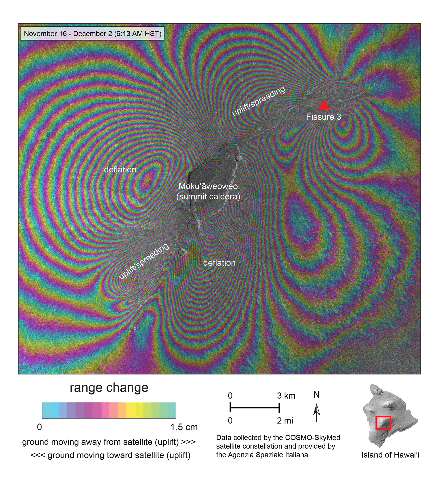
The complex patterns indicate overall deflation of the summit area by a maximum of more than 50 cm (20 in) as magma has flowed out of the main magma reservoir beneath the caldera to feed the eruption. There are also areas of uplift and spreading where magma reached the surface. Those areas are through the main part of the caldera and the SW side of the topographic caldera, and NE of the caldera into the NE Rift Zone. These data confirm that magma did not enter the SW Rift Zone and remained in the SW part of the summit region. The deformation in the NE Rift Zone indicates more than 50 cm (20 in) of uplift and spreading, although the image cannot resolve the deformation that is closest to the eruptive fissures themselves, where the ground motion was probably greater. The Saddle Road is off the image to the north.
Source : HVO , USGS.
Photos : Paradise Helicopters / Andrew Hara via Dane DuPont , USGS.
Italy , Vulcano :
WEEKLY BULLETIN, from November 21, 2022 to November 27, 2022. (issue date November 29, 2022)
ACTIVITY STATUS SUMMARY
In the light of the monitoring data, it is highlighted:
1) Temperature of the crater fumaroles: Along the summit rim, the weekly reference value for the maximum emission temperature was 371°C.
2) CO2 flux in the crater area: The CO2 flux in the crater area remains at medium-high values.
3) SO2 flux in the crater area: at a medium-high level and moderately increasing
4) Geochemistry of fumarolic gases: There are no updates.
5) CO2 fluxes at the base of the La Fossa cone and in the Vulcano Porto area: The CO2 fluxes recorded at the sites of Rimessa, C. Sicilia show stable values, always above background levels. The P4max site displays low values, while values close to the background noise are recorded on the Faraglione site.

6) Geochemistry of thermal aquifers: Stable but high temperature values are recorded in the well of Camping Sicilia. The conductivity sensor is faulty. There are no new updates for the level and conductivity values measured in the waters of the Bambara well
7) Local seismicity: Low occurrence rate of local micro-seismicity.
8) Regional seismicity: No earthquake with Ml>=1.0 was located, during the week in question, in the area of the island of Vulcano.
9) Deformations – GNSS: The network of permanent GNSS stations has not recorded any significant variations during the last week.
10) Deformations – Inclinometry: The inclinometric network did not record any significant variations.
11) Gravimetry: There are no significant medium-long term variations.
12) Other Comments: Mobile GNSS. The GNSS mobile network acquires and transmits movements in real time at a frequency of 1 Hz. The historical series acquired so far do not show significant variations around the Porto di Levante area.
Source et photo : INGV.
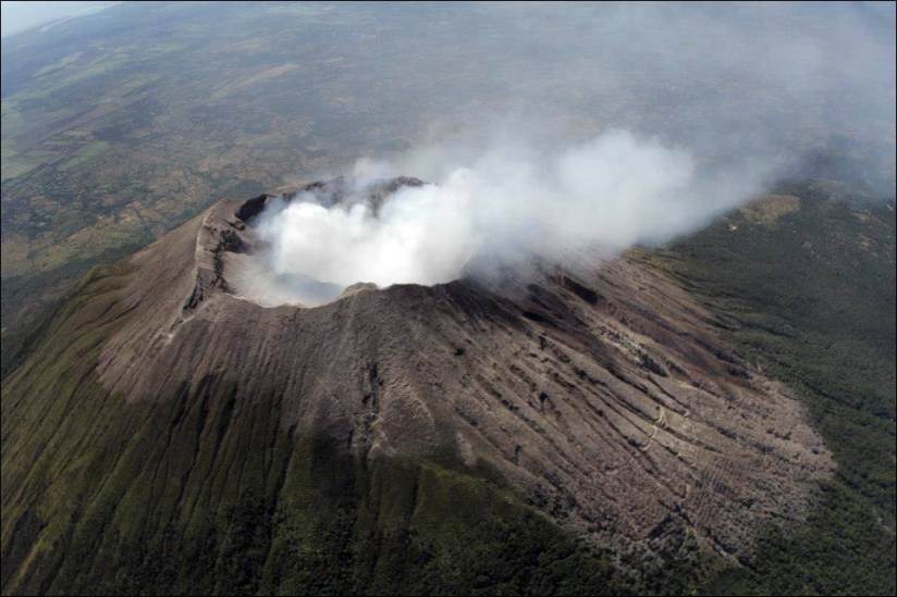
El Salvador , San Miguel ( Chaparrastique) :
Special Report No. 19, Release date and time: 2022-12-02 11:00:00
SUMMARY :
The San Miguel volcano has intensified its activity over the past weekend, generating explosions of greater intensity and height through its central crater, which corresponds to an eruptive phase of intensity 1 (on an explosive index scale from 0 to 8).
This week, the number of explosions has been reduced, so the time between each explosion has increased, the seismicity does not show increasing patterns and the gas (SO2) measurements are low. These periods of relative decrease in volcanic activity can be attributed to: (1) relaxation of eruptive activity, (2) temporary obstruction of the main conduit by internal collapse, (3) there is no longer of water for the heat to interact, (4) the previous 3 occurring at the same time.
This activity was attributed to contact with water and high temperature sectors inside the volcano. In ash samples taken after the most intense eruptions last weekend, the proportion of juvenile material increased; However, the content of pre-existing material predominates by 70%. This may indicate that if in the future the activity of the volcano intensifies, it could be mainly magmatic.
Since Tuesday November 15, the San Miguel volcano, the total number of explosions recorded to date is 194, with a daily average of 12. The average height reached by the explosions throughout the event was about 500 meters. Over the past 3 days, no explosions have been observed across the central crater.
Seismicity:
Regarding the seismicity recorded by the San Miguel Volcanic Station (VSM) located on the northern flank at 1700m altitude (meters above sea level), we are currently monitoring the evolution of the recordings to determine if there is an evolution of the activity of the volcano.
%2014.00.59.png)
Seismic recording of the VSM station.
Gas:
Gas measurements taken in the field, with DOAS Mobile equipment, indicate sulfur dioxide values well below the historical base threshold of the San Miguel volcano, which is 300 tons per day. Spot measurements were made during the explosions, which reached values of 1200 tons per day, during one of the largest explosions. However, during Sunday’s explosions, these concentrations have declined and the most recent measurements are well below the baseline threshold.
Source : MARN.
Photo : via Volcanohotspot
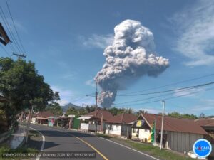
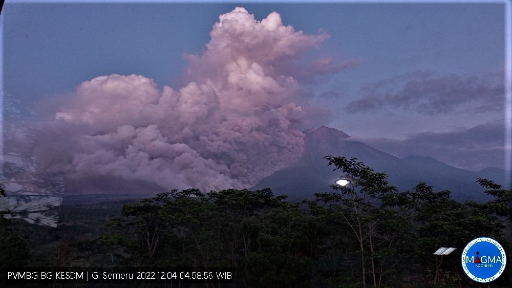
Indonesia , Semeru :
Mount Semeru erupted on Sunday, December 4, 2022 at 2:46 a.m. WIB with an ash column height observed at ± 1500 m above the summit (± 5176 m above sea level). The ash column was observed to be gray with medium to thick intensity, oriented to the Southeast and South. This eruption was recorded on a seismograph with a maximum amplitude of 35 mm.
VOLCANO OBSERVATORY NOTICE FOR AVIATION – VONA
Issued : November 04 , 2022
Volcano : Semeru (263300)
Current Aviation Colour Code : RED
Previous Aviation Colour Code : orange
Source : Semeru Volcano Observatory
Notice Number : 2022SMR710
Volcano Location : S 08 deg 06 min 29 sec E 112 deg 55 min 12 sec
Area : East java, Indonesia
Summit Elevation : 11763 FT (3676 M)
Volcanic Activity Summary :
Eruption with volcanic ash cloud at 02h18 UTC (09h18 local).
Volcanic Cloud Height :
Best estimate of ash-cloud top is around 27763 FT (8676 M) above sea level or 16000 FT (5000 M) above summit. May be higher than what can be observed clearly. Source of height data: ground observer.
Other Volcanic Cloud Information :
Ash cloud moving from southwest, west to northwest. Volcanic ash is observed to be gray to brown. The intensity of volcanic ash is observed to be thick.
Remarks :
Eruption and ash emission is continuing. Eruption recorded on seismogram with maximum amplitude 35 mm.
Source : Magma Indonésie .
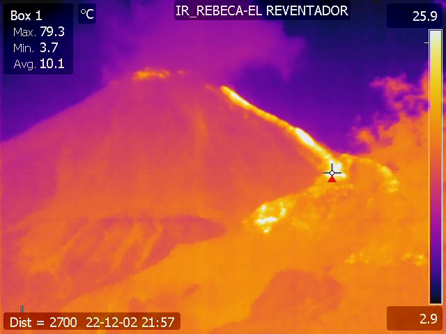
Ecuador , Reventador :
DAILY REPORT OF THE STATE OF THE REVENTADOR VOLCANO, Saturday December 03, 2022.
Information Geophysical Institute – EPN.
Surface Activity Level: Moderate, Surface Trend: No change
Internal activity level: Moderate, Internal trend: No change.
Seismicity: From December 02, 2022, 11:00 a.m. to December 03, 2022, 11:00 a.m.:
Due to technical problems in the REVS reference station, the counting of events was carried out for a duration of 11 hours of operation.
Explosion (EXP): 24
Long Periods (LP): 47
Emission Tremors (TREMI): 9.
Harmonic Tremors (TRARM): 2
Rains / Lahars:
Moderate rains were recorded yesterday night, according to information from the SOTE guardian of the Reventador area.
Emission / Ash Column:
With the IG-EPN cameras, gas and ash emissions were observed at heights of up to 1000 meters above crater level in a west and northwest direction. Heavy cloud cover prevented ash emissions from being seen by the GOES-16 satellite.
Gas:
The MOUNTS system reported 26.8 tons of SO2, measured on 2022-02-12 at 13:56 TL.
Other Monitoring Parameters:
No thermal anomaly has been detected in the last 24 hours.
Observation:
The volcano area was partially cleared yesterday afternoon. The lava flow continues to be recorded on the northeast flank. For the moment, it remains cloudy.
Alert level: Orange.
Source : IGEPN.
Photos : IGEPN