December 03 , 2022.
Hawaii , Mauna Loa :
Friday, December 2, 2022, 9:52 AM HST (Friday, December 2, 2022, 19:52 UTC)
19°28’30 » N 155°36’29 » W,
Summit Elevation 13681 ft (4170 m)
Current Volcano Alert Level: WARNING
Current Aviation Color Code: RED
Activity Summary:
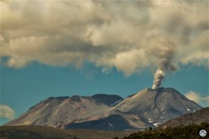
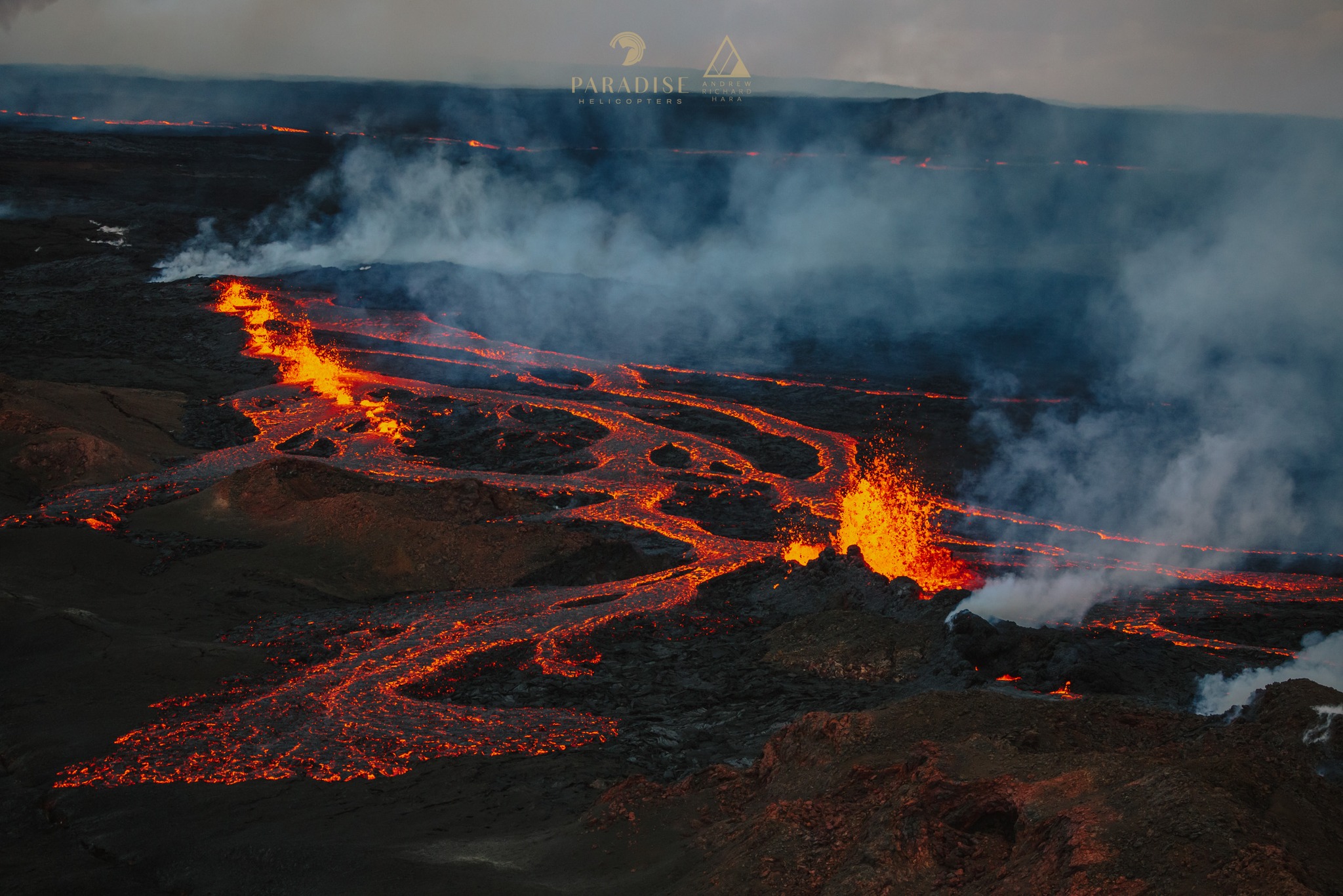
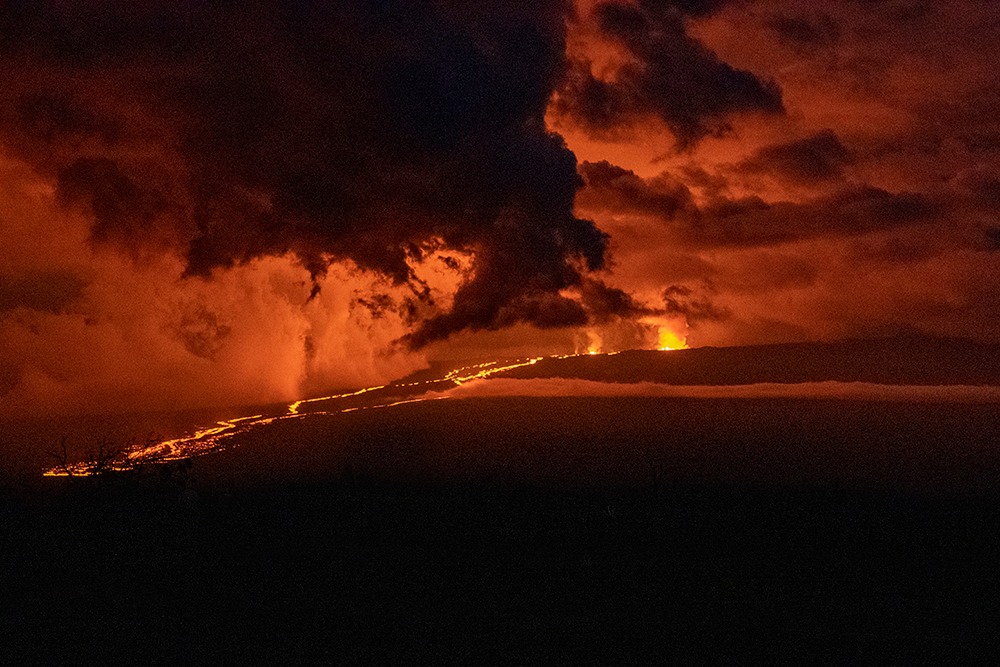
The Northeast Rift Zone eruption of Mauna Loa continues, with one active fissure, fissure 3, feeding a lava flow downslope. Fissure 4 is sluggish, and fissures 1 and 2 are no longer active.
Fissure 3 is generating a lava flow traveling to the north toward the Daniel K. Inouye Highway (Saddle Road) that has reached relatively flatter ground and slowed down significantly over the past couple of days, as expected. Over the past 24 hours, the lava flow has advanced at a rate of about 150 feet per hour (45 meters per hour). As of 7:00 a.m. HST this morning, the flow front is about 2.7 miles (4.3 km) from the Daniel K. Inouye Highway (Saddle Road).
Fissure 4 continues to be active, but with very little eruptive activity observed this morning.
Advance rates may be highly variable over the coming days and weeks due to the way lava is emplaced on flat ground. On flat ground, lava flows spread out and inflate. Individual lobes may advance quickly, and then stall. Additional breakouts may occur if lava channels get clogged upslope. There are many variables at play and both the direction and timing of flow advance are expected to change over periods of hours to days, making it difficult to estimate when or if the flow will impact Daniel K. Inouye Highway.
Volcanic gas plumes are lofting high and vertically into the atmosphere before being blown to the west at high altitude, generating vog in areas downwind. Pele’s hair (strands of volcanic glass) fragments are being wafted great distances and have been reported as far the Mauna Kea Visitor Information Station.
Sulfur dioxide (SO2) emission rates of approximately 180,000 tonnes per day (t/d) were measured on December 1, 2022.
Tremor ( signal associated with subsurface fluid movement) continues in the location of the currently active fissures. This indicates that magma is still being supplied to the fissure, and activity is likely to continue as long as we see this signal.
There is no active lava within Moku’āweoweo caldera, and the Southwest Rift Zone is not erupting. We do not expect any eruptive activity outside the Northeast Rift Zone. No property is at risk currently.
Friday, December 2, 2022, 4:39 PM HST (Saturday, December 3, 2022, 02:39 UTC)
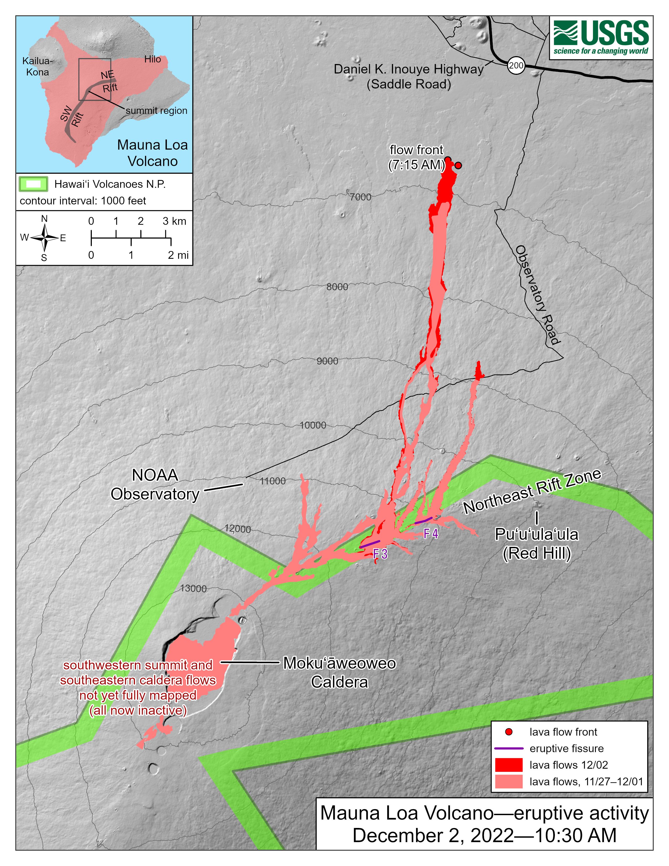
The Northeast Rift Zone eruption of Mauna Loa continues, with little change since this morning. One active fissure, fissure 3, is feeding a lava flow downslope. Fissure 4 is sluggish, and fissures 1 and 2 are no longer active. Webcam and satellite views overnight allowed USGS analysts to accurately map some of the most active flows, displayed in red here, along with older flows further uprift, in part of Mokuʻāweoweo Caldera, and in the upper summit region southwest of the caldera. Elsewhere the progression of the flows is marked by points for the flow fronts, mapped by HVO field crews (current as of 10:30 AM HT).
Around fissure 3, a cone is developing; it was measured as approximately 157 (48 m) high today.
Source : HVO
Photos : Andrew Hara / Paradise helicopters , Timothy Ewing , USGS.
La Réunion , Piton de la Fournaise :
Seismicity
In November 2022, the OVPF-IPGP recorded at the level of the Piton de la Fournaise massif in total:
• 31 superficial volcano-tectonic earthquakes (0 to 2.5 km above sea level) under the summit craters;
• no deep earthquakes (below sea level);
• 1109 landslides.
The month of November 2022 will have been marked by low seismicity at the level of Piton de la Fournaise with an average of 1 volcano-tectonic earthquake per day.
Most of these events were located under the eastern rim of the Dolomieu crater.
The month of November will also have been marked by numerous landslides (in the Cratère Dolomieu, in the ramparts of the Rivière de l’Est and at the level of the flow of the eruption of September-October 2022).

Deformation
With the end of the last eruption on October 5, 2022, a resumption of inflation of the whole building was recorded until October 23. Since then, no significant deformation of the building has been recorded.
Balance sheet
The replenishment of magma and the pressurization of the superficial magma reservoir which had resumed following the end of the September-October 2022 eruption ceased at the end of October (the 23rd).
At the same time, seismicity has remained low since the end of the last eruption on October 5, with less than one – to one – earthquake per day recorded under the summit craters.
It should be noted that since 2016, the replenishments of the superficial magmatic reservoir under the Piton de la Fournaise are done by pulses, thus such phases of calm in the deformations and seismicity have already been observed on several occasions between 2016 and 2019 over periods ranging from 15 to 80 days approximately.
Source : OVPF
Photo : Imaz Press
Alaska , Pavlof :
55°25’2″ N 161°53’37 » W,
Summit Elevation 8261 ft (2518 m)
Current Volcano Alert Level: WATCH
Current Aviation Color Code: ORANGE
Pavlof Volcano continues to erupt from a vent just below the summit on the volcano’s east flank. Nearly continuous volcanic tremor was recorded throughout the week and small explosions were observed on December 1st and 2nd on local seismic and infrasound stations. Elevated surface temperatures were observed in satellite data on most days. A flowage event likely resulting from the interaction of hot rocks with ice and snow on the flank of the volcano was observed in seismic data and series of webcam image on November 28. This event produced an ash and gas cloud that reached 15,000 – 20,000 feet above sea level, before dissipating within tens of minutes. Satellite and webcam images confirmed that the deposit extends about 3 miles (5 km) down the southeast flank, which is the largest flowage event during this current eruptive period.
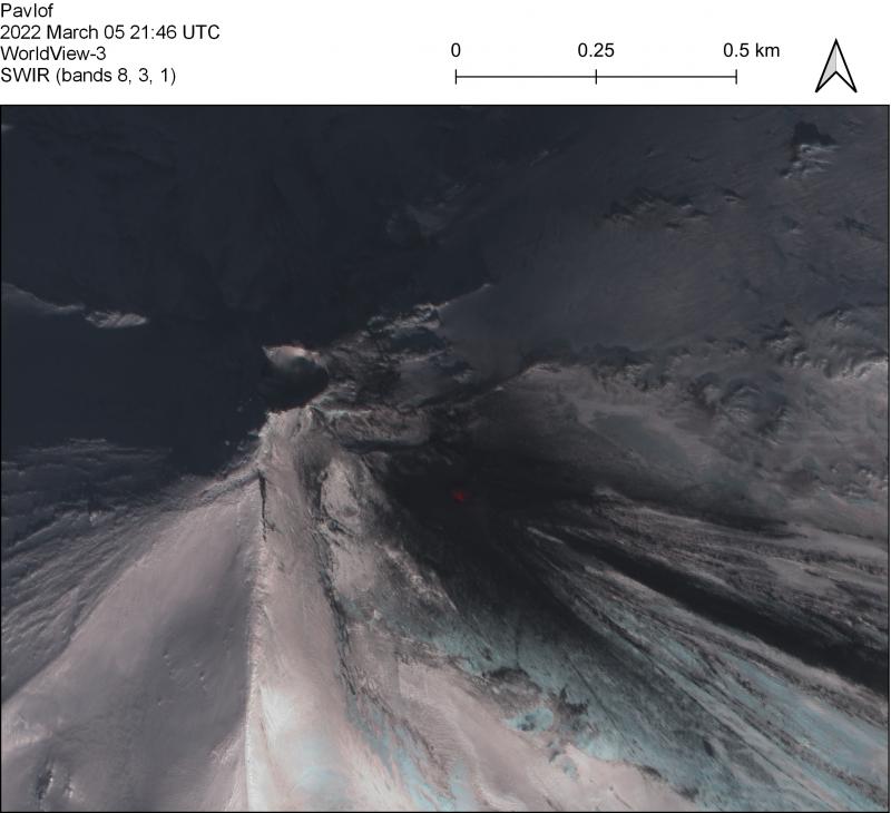
Periods of lava spatter and fountaining from the vent on the volcano’s upper east flank have been occurring since mid-November 2021. This activity has built a small cone and sent lava flows down the flank that melt the snow and ice and produce variable amounts of meltwater. The meltwater typically incorporates loose debris on the flank of the volcano and forms thin (less than 2 m thick) lahars. The lahar deposits extend down the east-southeast flank for several kilometers, not quite to the base of the volcano.
Previous eruptions of Pavlof indicate that the level of unrest can change quickly and the progression to more significant eruptive activity can occur with little or no warning.
Pavlof is monitored by local seismic and infrasound sensors, satellite data, web cameras, and regional infrasound and lightning networks.
Source : AVO
Photo : Loewen, M. W.( archive AVO).
Indonesia , Merapi :
Report on the activity of Mount Merapi from November 18, 2022 to November 24, 2022, Published on November 25, 2022
RESULTS OF OBSERVATIONS
Visual
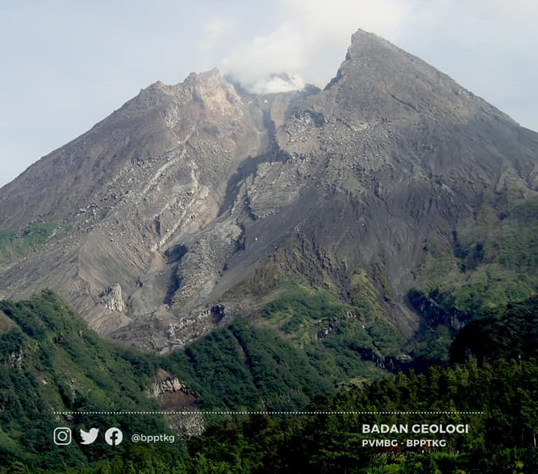
The weather around Mount Merapi is usually sunny in the morning and afternoon, while the evening is foggy. White, thin to medium thickness, low pressure, 150m high smoke was observed from the Kaliurang Mount Merapi observation post on November 29, 2022 at 05:10 WIB.
This week, there were 5 lava avalanches towards the South-West (Kali Bebeng) with a slip distance of 1,500 m. The noise of the descent was heard 1 time from Babadan Post with medium intensity.
– There is no significant morphological change in the South-West dome and the central dome. The volume of the South-West dome is calculated fixed, i.e. 1,616,500 m3, while for the middle dome it is 2,772,000 m3.
Seismicity
This week, the seismicity of Mount Merapi showed:
48 deep volcanic earthquakes (VTB)
365 Deep Volcanic Earthquakes (VTA),
289 avalanche earthquakes (RF),
26 emission earthquakes (DG),
8 tectonic earthquakes (TT).
The intensity of this week’s seismicity is still quite high.
Deformation
The Mount Merapi deformation that was monitored using EDM and GPS this week showed a shortening rate of 0.6 cm/day.
Rain and lahars:
This week, there was rain at Kaliurang observation post with a rain intensity of 28 mm/h for 85 minutes on November 29, 2022. It is reported that there was an increase in flow in the Gendok and Kuning rivers.
Conclusion
Based on the results of visual and instrumental observations, it is concluded that:
-The volcanic activity of Mount Merapi is still quite high in the form of effusive eruption activity. The state of the activity is defined at the « SIAGA » level.
-The current potential dangers are lava avalanches and hot clouds in the South-South-West sector including the Boyong River up to 5 km, the Bedog, Krasak, Bebeng Rivers up to 7 km. In the South-East sector, they cover the Woro River with a maximum of 3 km and the Gendol River for 5 km. While the ejection of volcanic materials during an explosive eruption can reach a radius of 3 km around the summit.
Source et photo : BPPTKG.
Kamchatka , Sheveluch :
VOLCANO OBSERVATORY NOTICE FOR AVIATION (VONA)
Issued: November 03 , 2022
Volcano: Sheveluch (CAVW #300270)
Current aviation colour code: ORANGE
Previous aviation colour code: orange
Source: KVERT
Notice Number: 2022-185
Volcano Location: N 56 deg 38 min E 161 deg 18 min
Area: Kamchatka, Russia
Summit Elevation: 3283 m (10768.24 ft), the dome elevation ~2500 m (8200 ft)
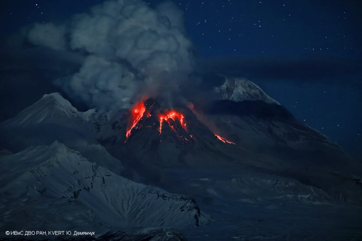
Volcanic Activity Summary:
A growth of the lava dome continues, a strong fumarole activity, an incandescence of the lava dome, explosions, and hot avalanches accompanies this process. Satellite data by KVERT showed a strong gas-steam plumes containing some amount of ash associated with hot avalanches collapses stretched for 40 km to the north of the volcano.
The extrusive eruption of the volcano continues. Ash explosions up to 10-15 km (32,800-49,200 ft) a.s.l. could occur at any time. Ongoing activity could affect international and low-flying aircraft.
Volcanic cloud height:
4500 m (14760 ft) AMSL Time and method of ash plume/cloud height determination: 20221203/0245Z – Video data
Other volcanic cloud information:
Distance of ash plume/cloud of the volcano: 40 km (25 mi)
Direction of drift of ash plume/cloud of the volcano: N / azimuth 10 deg
Time and method of ash plume/cloud determination: 20221203/0150Z – Himawari-8 14m15
Source : Kvert .
Photo : Yu. Demyanchuk, IVS FEB RAS, KVERT