November 07 , 2022.
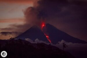
Chile , Villarica :
Special Report on Volcanic Activity (REAV), De la Auracania region, Villarica volcano, November 07, 2022, 01:30 a.m. local time (mainland Chile).
The National Service of Geology and Mines of Chile (Sernageomin) publishes the following PRELIMINARY information, obtained through the monitoring equipment of the National Volcanic Monitoring Network (RNVV), processed and analyzed at the Volcanological Observatory of the Southern Andes ( Ovdas):
Monday, November 07, 2022, at 00:32 local time (03:32 UTC), the monitoring stations installed near the Villarica volcano recorded an earthquake associated with fluid dynamics (long period type), inside the volcanic system.
The characteristics of earthquakes after their analysis are as follows:
ORIGINAL TIME: 00:32 local time (03:32 UTC)
REDUCED TRAVEL: 37.3 (cm*cm)
ACOUSTIC SIGNAL: 0.6 Pascals (Pa) reduced to 1 km
The characteristics of surface activity are as follows:
GLOW HEIGHT: 80 m above the emission point
COMMENTS:
Following the reported event, no events with similar characteristics were recorded.
The volcanic technical alert remains at the Green level.
Sources : Sernageomin.
Photo : horadelaluz_martinifotografia
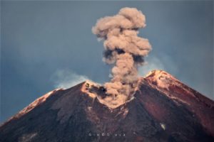
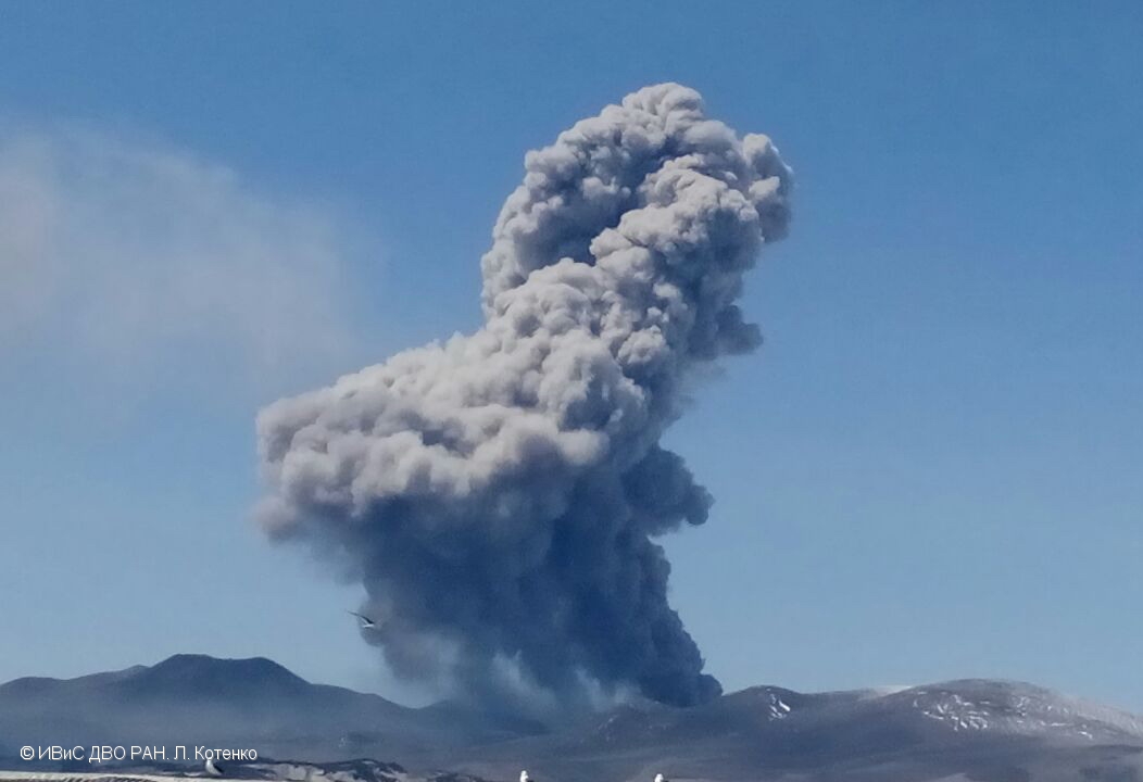
Kamchatka / Kuril Islands , Sheveluch / Ebeko :
VOLCANO OBSERVATORY NOTICE FOR AVIATION (VONA)
Issued: November 06 , 2022
Volcano: Sheveluch (CAVW #300270)
Current aviation colour code: ORANGE
Previous aviation colour code: orange
Source: KVERT
Notice Number: 2022-166
Volcano Location: N 56 deg 38 min E 161 deg 18 min
Area: Kamchatka, Russia
Summit Elevation: 3283 m (10768.24 ft), the dome elevation ~2500 m (8200 ft)

Volcanic Activity Summary:
A growth of the lava dome continues, a strong fumarole activity, an incandescence of the lava dome, explosions, and hot avalanches accompanies this process. Video and satellite data by KVERT show: the ash plume from hot avalanches which collapsing from the the different flanks of the lava dome is extending for 130 km to the eastnortheast of the volcano.
The extrusive eruption of the volcano continues. Ash explosions up to 10-15 km (32,800-49,200 ft) a.s.l. could occur at any time. Ongoing activity could affect international and low-flying aircraft.
Volcanic cloud height:
3500-4000 m (11480-13120 ft) AMSL Time and method of ash plume/cloud height determination: 20221106/0510Z – Himawari-8 14m15
Other volcanic cloud information:
Distance of ash plume/cloud of the volcano: 130 km (81 mi)
Direction of drift of ash plume/cloud of the volcano: E / azimuth 80 deg
Time and method of ash plume/cloud determination: 20221106/0510Z – Himawari-8 14m15
————————————————————————————————————-
VOLCANO OBSERVATORY NOTICE FOR AVIATION (VONA)
Issued: November 07 , 2022
Volcano: Ebeko (CAVW #290380)
Current aviation colour code: ORANGE
Previous aviation colour code: orange
Source: KVERT
Notice Number: 2022-167
Volcano Location: N 50 deg 41 min E 156 deg 0 min
Area: Northern Kuriles, Russia
Summit Elevation: 1156 m (3791.68 ft)
Volcanic Activity Summary:
A moderate eruptive activity of the volcano continues. According to visual data by volcanologists from Severo-Kurilsk, explosions sent ash up to 3 km a.s.l., an ash cloud is drifting to the east of the volcano.
This activity continues. Ash explosions up to 6 km (19,700 ft) a.s.l. could occur at any time. Ongoing activity could affect low-flying aircraft and airport of Severo-Kurilsk.
Volcanic cloud height:
3000 m (9840 ft) AMSL Time and method of ash plume/cloud height determination: 20221107/0032Z – Visual data
Other volcanic cloud information:
Distance of ash plume/cloud of the volcano: 5 km (3 mi)
Direction of drift of ash plume/cloud of the volcano: E / azimuth 90 deg
Time and method of ash plume/cloud determination: 20221107/0032Z – Visual data
Source : Kvert.
Photo : Yu. Demyanchuk, IVS FEB RAS, KVERT , L. Kotenko, IVS FEB RAS .
Colomba , Chiles / Cerro Negro :
Chiles and Cerro Negro volcanoes weekly activity bulletin
Volcano activity continues at YELLOW LEVEL ■ (III): CHANGES IN THE BEHAVIOR OF VOLCANIC ACTIVITY.
From monitoring the activity of VOLCANOES CHILES and CERRO NEGRO, the COLOMBIAN GEOLOGICAL SERVICE (SGC) reports that:
In the period between October 25 and October 31, 2022, activity showed a decrease in the number and energy of earthquakes, with a predominance of those associated with rock fracture.
The events were mainly located in the South and Southwest quadrant of the Chiles volcano, at distances less than 4 km, with depths less than 6 km from its summit (4700 m) and with a maximum magnitude of 1.8. A few other events were located in a scattered manner, at distances of up to 12 km and at depths less than 13 km.

The process of soil deformation, observed instrumentally, has been maintained since the end of March 2022.
Based on the current behavior of this seismicity and what has been historically recorded in this active volcanic region, the possibility of occurrence of high energy earthquakes that can be felt by the inhabitants of the volcanic influence zone is not excluded. .
The COLOMBIAN GEOLOGICAL SERVICE and the GEOPHYSICAL INSTITUTE OF THE NATIONAL POLYTECHNICAL SCHOOL of ECUADOR will continue to monitor the evolution of the volcanic phenomenon and will inform in a timely manner of any changes that may occur.
Source : SGC.
Photo : Igepn
Philippines , Mayon :
MAYON VOLCANO BULLETIN 07 November 2022 8:00 AM
In the past 24-hour period, the Mayon Volcano Network recorded one (1) volcanic earthquake. Moderate emission of white steam-laden plumes that rose 200 meters before drifting to the general west was observed. Sulfur dioxide (SO2) emission was last measured at an average of 276 tonnes/day on 03 November 2022. Based on ground deformation parameters from EDM, Precise Leveling, electronic tilt, and continuous GPS monitoring, Mayon Volcano has been slightly inflated since 2020.

Alert Level 2 (Increased Unrest) prevails over Mayon Volcano. The public is reminded that there is current unrest driven by shallow magmatic processes that could eventually lead to phreatic eruptions or even precede hazardous magmatic eruptions. Entry into the six (6) kilometer-radius Permanent Danger Zone (PDZ) is strictly prohibited to minimize risks from sudden explosions, rockfalls, and landslides. In case of ash fall events that may affect communities downwind of Mayon’s crater, people should cover their nose and mouth with a damp, clean cloth, or dust mask. Civil aviation authorities must also advise pilots to avoid flying close to the volcano’s summit as ash from any sudden eruption can be hazardous to aircraft. DOST-PHIVOLCS maintains close monitoring of Mayon Volcano and any new development will be communicated to all concerned stakeholders.
Source et photo : DOST-PHIVOLCS.
Hawaii , Kilauea :
19°25’16 » N 155°17’13 » W,
Summit Elevation 4091 ft (1247 m)
Current Volcano Alert Level: WATCH
Current Aviation Color Code: ORANGE
Activity Summary:
The summit eruption of Kīlauea Volcano, within Halemaʻumaʻu crater, continued over the past 24 hours. All recent eruptive activity has been confined to the crater. No significant changes have been observed at the summit or in either rift zone.
Halemaʻumaʻu Lava Lake Observations:
Eruption of lava from the western vent into the active lava lake and onto the crater floor continued over the past 24 hours. The active part of the lava lake has been steady over the past 24 hours. Overflight measurements from October 28, 2022, indicated that the crater floor had seen a total rise of about 143 meters (469 feet), since the beginning of this eruption on September 29, 2021.
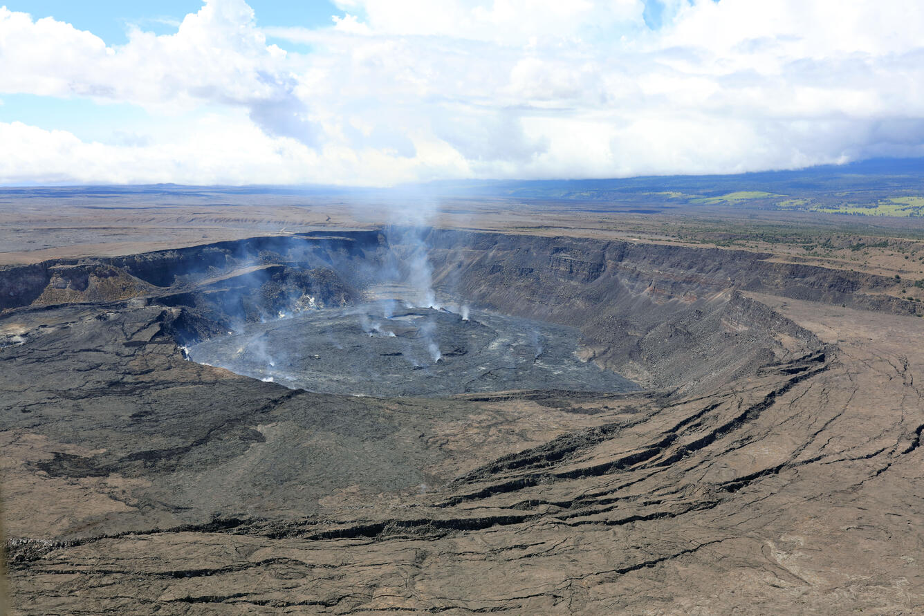
A southwest-facing view of the eruption within Halema‘uma‘u, at the summit of Kīlauea. Diffuse steam and volcanic gases are emitted from the crater floor and eruption site. The most recent Kīlauea summit sulfur dioxide (SO2) emission rate was measured on October 22, 2022, at approximately 700 tonnes per day (t/d).
Summit Observations:
Summit tiltmeters recorded deflationary tilt over most of the past 24 hours, switching to inflationary tilt this morning at 6:30 a.m. Volcanic tremor remains above background levels. A sulfur dioxide (SO2) emission rate of approximately 700 tonnes per day (t/d) was measured on October 22, 2022.
Rift Zone Observations:
No unusual activity has been noted along the East Rift Zone or Southwest Rift Zone; low rates of ground deformation and seismicity continue along both. Measurements from continuous gas monitoring stations downwind of Puʻuʻōʻō in the middle East Rift Zone remain below detection limits for SO2, indicating that SO2 emissions from Puʻuʻōʻō are negligible.
Source : HVO.
Photo : USGS/ K. Mulliken.